Cranberry Isles, Maine
Submit your own pictures of this town and show them to the world
- OSM Map
- General Map
- Google Map
- MSN Map
Population change since 2000: +10.2%
 |
| Males: 77 | |
| Females: 64 |
| Median resident age: | 47.7 years |
| Maine median age: | 43.0 years |
Zip code: 04646
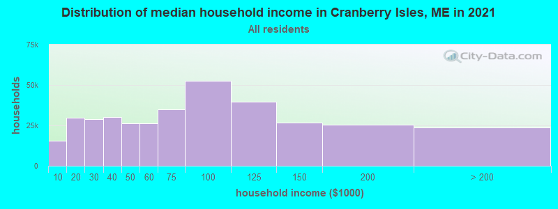
| Cranberry Isles: | $71,299 |
| ME: | $69,543 |
Estimated per capita income in 2022: $48,472 (it was $23,873 in 2000)
Estimated median house or condo value in 2022: $536,973 (it was $187,500 in 2000)
| Cranberry Isles: | $536,973 |
| ME: | $290,600 |
Mean prices in 2022: all housing units: $379,336; detached houses: $396,802; townhouses or other attached units: $600,716; in 2-unit structures: $274,479; in 3-to-4-unit structures: $212,346; in 5-or-more-unit structures: $146,369; mobile homes: $158,183; occupied boats, rvs, vans, etc.: $16,454
Cranberry Isles, ME residents, houses, and apartments details
Detailed information about poverty and poor residents in Cranberry Isles, ME


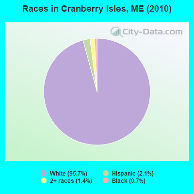
- 13595.7%White alone
- 32.1%Hispanic
- 21.4%Two or more races
- 10.7%Black alone
 Recent articles from our blog. Our writers, many of them Ph.D. graduates or candidates, create easy-to-read articles on a wide variety of topics.

 | Am I missing the Maine experience?....In Maine (106 replies) |
Latest news from Cranberry Isles, ME collected exclusively by city-data.com from local newspapers, TV, and radio stations
Ancestries: English (43.8%), Irish (18.8%), Italian (7.0%), German (6.2%), Scottish (6.2%), United States (6.2%).
Current Local Time: EST time zone
Incorporated on 03/16/1930
Elevation: 15 feet
Land area: 3.17 square miles.
Population density: 44 people per square mile (very low).
2 residents are foreign born
| This town: | 1.6% |
| Maine: | 2.9% |
| Cranberry Isles town: | 0.4% ($750) |
| Maine: | 1.5% ($1,417) |
Nearest city with pop. 50,000+: Portland, ME  (109.1 miles , pop. 64,249).
Nearest city with pop. 200,000+: Boston, MA (196.4 miles , pop. 589,141).
Nearest city with pop. 1,000,000+: Bronx, NY (371.6 miles , pop. 1,332,650).
Nearest cities:
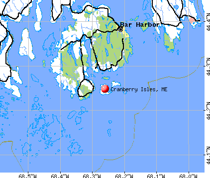
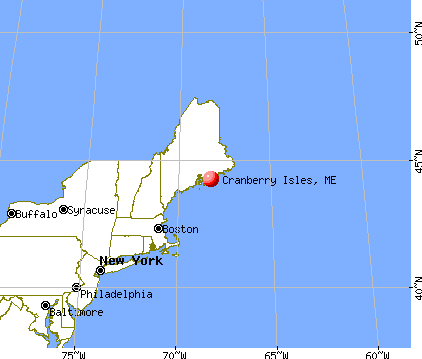
), )Latitude: 44.26 N, Longitude: 68.24 W
Area code commonly used in this area: 207

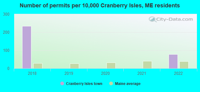
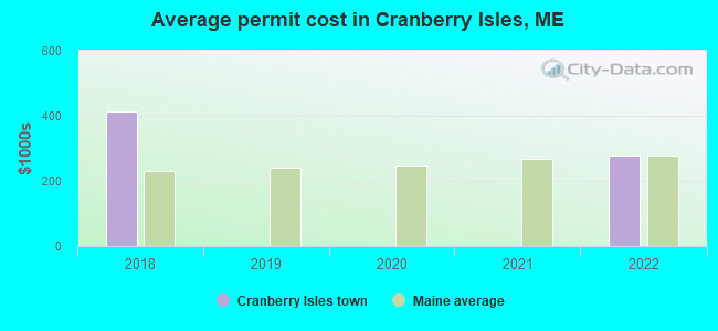
Single-family new house construction building permits:
- 2022: 1 building, cost: $279,200
- 2018: 3 buildings, average cost: $413,200
| Here: | 1.4% |
| Maine: | 3.4% |
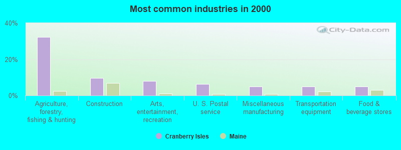
- Agriculture, forestry, fishing & hunting (32.3%)
- Construction (9.7%)
- Arts, entertainment, recreation (8.1%)
- U. S. Postal service (6.5%)
- Miscellaneous manufacturing (4.8%)
- Transportation equipment (4.8%)
- Food & beverage stores (4.8%)

- Agriculture, forestry, fishing & hunting (54.3%)
- Arts, entertainment, recreation (14.3%)
- Groceries & related products merchant wholesalers (5.7%)
- Construction (5.7%)
- Transportation equipment (5.7%)
- Food & beverage stores (5.7%)
- Administrative & support & waste management services (5.7%)

- Construction (14.8%)
- U. S. Postal service (14.8%)
- Miscellaneous manufacturing (11.1%)
- Public administration (11.1%)
- Real estate & rental & leasing (7.4%)
- Professional, scientific, technical services (7.4%)
- Educational services (7.4%)
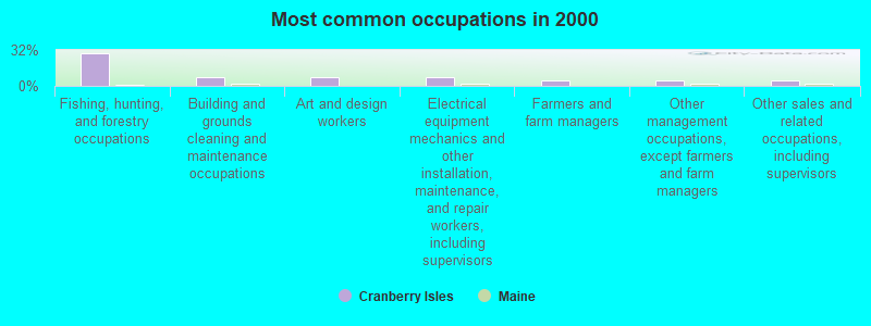
- Fishing, hunting, and forestry occupations (29.0%)
- Building and grounds cleaning and maintenance occupations (8.1%)
- Art and design workers (8.1%)
- Electrical equipment mechanics and other installation, maintenance, and repair workers, including supervisors (8.1%)
- Farmers and farm managers (4.8%)
- Other management occupations, except farmers and farm managers (4.8%)
- Other sales and related occupations, including supervisors (4.8%)

- Fishing, hunting, and forestry occupations (48.6%)
- Farmers and farm managers (8.6%)
- Building and grounds cleaning and maintenance occupations (8.6%)
- Electrical equipment mechanics and other installation, maintenance, and repair workers, including supervisors (8.6%)
- Cooks and food preparation workers (5.7%)
- Art and design workers (5.7%)
- Supervisors, construction and extraction workers (5.7%)

- Art and design workers (11.1%)
- Other management occupations, except farmers and farm managers (11.1%)
- Other sales and related occupations, including supervisors (11.1%)
- Preschool, kindergarten, elementary, and middle school teachers (7.4%)
- Information and record clerks, except customer service representatives (7.4%)
- Architects, surveyors, and cartographers (7.4%)
- Building and grounds cleaning and maintenance occupations (7.4%)
Average climate in Cranberry Isles, Maine
Based on data reported by over 4,000 weather stations


(lower is better)
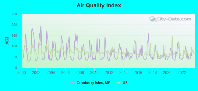
Air Quality Index (AQI) level in 2023 was 61.9. This is about average.
| City: | 61.9 |
| U.S.: | 72.6 |
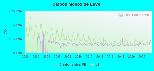
Carbon Monoxide (CO) [ppm] level in 2023 was 0.172. This is significantly better than average. Closest monitor was 6.3 miles away from the city center.
| City: | 0.172 |
| U.S.: | 0.251 |
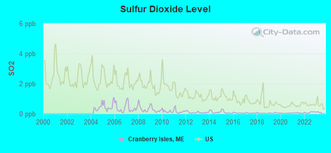
Sulfur Dioxide (SO2) [ppb] level in 2023 was 0.0636. This is significantly better than average. Closest monitor was 3.6 miles away from the city center.
| City: | 0.0636 |
| U.S.: | 1.5147 |
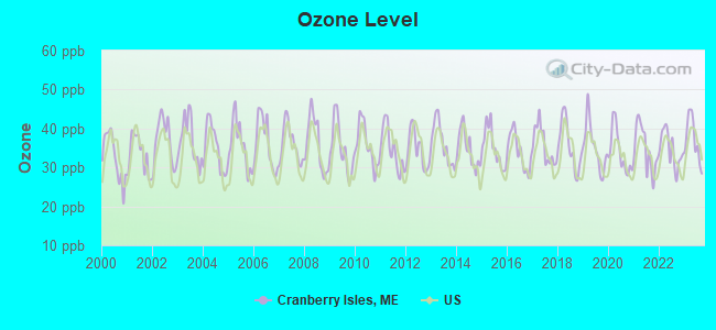
Ozone [ppb] level in 2023 was 37.1. This is about average. Closest monitor was 3.6 miles away from the city center.
| City: | 37.1 |
| U.S.: | 33.3 |
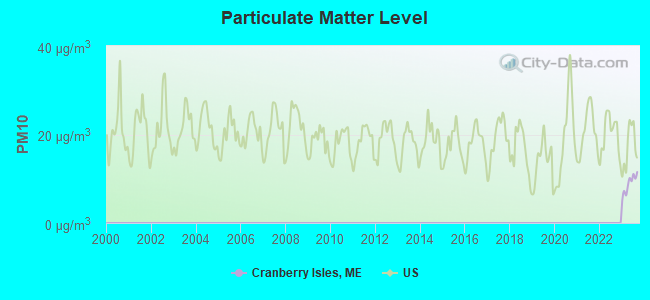
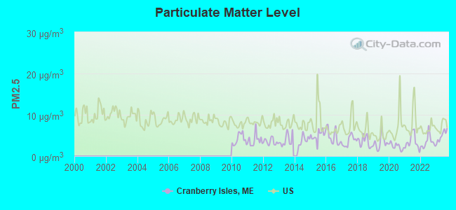
Particulate Matter (PM2.5) [µg/m3] level in 2023 was 4.90. This is significantly better than average. Closest monitor was 8.0 miles away from the city center.
| City: | 4.90 |
| U.S.: | 8.11 |
Earthquake activity:
Cranberry Isles-area historical earthquake activity is significantly above Maine state average. It is 81% smaller than the overall U.S. average.On 10/16/2012 at 23:12:25, a magnitude 4.7 (4.7 ML, Depth: 10.0 mi, Class: Light, Intensity: IV - V) earthquake occurred 128.8 miles away from the city center
On 4/20/2002 at 10:50:47, a magnitude 5.3 (5.3 ML, Depth: 3.0 mi, Class: Moderate, Intensity: VI - VII) earthquake occurred 270.3 miles away from the city center
On 4/20/2002 at 10:50:47, a magnitude 5.2 (5.2 MB, 4.2 MS, 5.2 MW, 5.0 MW) earthquake occurred 271.2 miles away from Cranberry Isles center
On 1/19/1982 at 00:14:42, a magnitude 4.7 (4.5 MB, 4.7 MD, 4.5 LG) earthquake occurred 175.6 miles away from Cranberry Isles center
On 10/7/1983 at 10:18:46, a magnitude 5.3 (5.1 MB, 5.3 LG, 5.1 ML) earthquake occurred 303.7 miles away from Cranberry Isles center
On 10/3/2006 at 00:07:38, a magnitude 3.7 (3.7 MD, Depth: 6.2 mi, Class: Light, Intensity: II - III) earthquake occurred 8.6 miles away from Cranberry Isles center
Magnitude types: regional Lg-wave magnitude (LG), body-wave magnitude (MB), duration magnitude (MD), local magnitude (ML), surface-wave magnitude (MS), moment magnitude (MW)
Natural disasters:
The number of natural disasters in Hancock County (18) is near the US average (15).Major Disasters (Presidential) Declared: 11
Emergencies Declared: 6
Causes of natural disasters: Floods: 9, Storms: 8, Snows: 5, Blizzard: 1, Heavy Rain: 1, Hurricane: 1, Ice Storm: 1, Landslide: 1, Snowfall: 1, Wind: 1, Winter Storm: 1, Other: 2 (Note: some incidents may be assigned to more than one category).

Hospitals and medical centers near Cranberry Isles:
Colleges/universities with over 2000 students nearest to Cranberry Isles:
- Husson University (about 48 miles; Bangor, ME; Full-time enrollment: 2,421)
- University of Maine (about 49 miles; Orono, ME; FT enrollment: 8,931)
- University of Maine at Augusta (about 78 miles; Augusta, ME; FT enrollment: 3,204)
- University of Maine at Farmington (about 99 miles; Farmington, ME; FT enrollment: 2,036)
- Southern Maine Community College (about 108 miles; South Portland, ME; FT enrollment: 4,666)
- University of Southern Maine (about 110 miles; Portland, ME; FT enrollment: 6,647)
- Saint Joseph's College of Maine (about 116 miles; Standish, ME; FT enrollment: 2,010)
Points of interest:
Notable locations in Cranberry Isles: Islesford Dock (A), Cranberry Isles Town Dock (B), Islesford Historical Museum (C), Islesford Emergency Medical Services (D), Cranberry Island Fishermens Co-operative (E). Display/hide their locations on the map
Swamps: The Heath (A). Display/hide its location on the map
Beach: Gilley Beach (A). Display/hide its location on the map
| This town: | 2.0 people |
| Maine: | 2.3 people |
| This town: | 47.1% |
| Whole state: | 62.9% |
| This town: | 12.9% |
| Whole state: | 9.4% |
No gay or lesbian households reported
| This town: | 13.3% |
| Whole state: | 10.9% |
| This town: | 7.0% |
| Whole state: | 4.1% |
For population 15 years and over in Cranberry Isles:
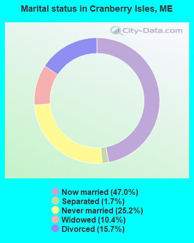
- Never married: 25.2%
- Now married: 47.0%
- Separated: 1.7%
- Widowed: 10.4%
- Divorced: 15.7%
For population 25 years and over in Cranberry Isles:
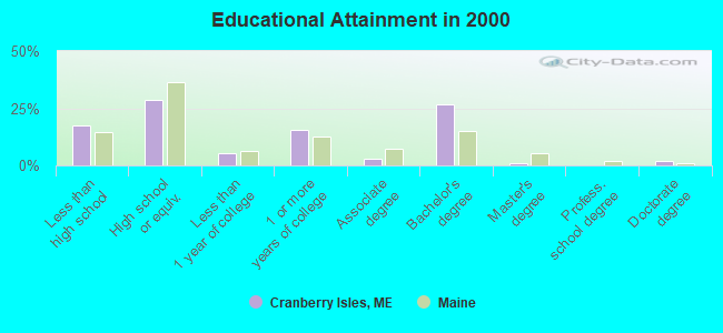
- High school or higher: 82.4%
- Bachelor's degree or higher: 29.6%
- Graduate or professional degree: 2.8%
- Unemployed: 3.1%
- Mean travel time to work (commute): 13.4 minutes
| Here: | 12.2 |
| Maine average: | 11.2 |


Graphs represent county-level data. Detailed 2008 Election Results
Political contributions by individuals in Cranberry Isles, ME
Religion statistics for Cranberry Isles, ME (based on Hancock County data)


| Religion | Adherents | Congregations |
|---|---|---|
| Mainline Protestant | 4,691 | 58 |
| Catholic | 2,523 | 9 |
| Evangelical Protestant | 1,288 | 23 |
| Other | 820 | 11 |
| None | 45,096 | - |
Food Environment Statistics:
| Hancock County: | 6.01 / 10,000 pop. |
| State: | 2.80 / 10,000 pop. |
| Hancock County: | 1.69 / 10,000 pop. |
| State: | 2.20 / 10,000 pop. |
| Hancock County: | 4.89 / 10,000 pop. |
| Maine: | 5.75 / 10,000 pop. |
| Hancock County: | 21.61 / 10,000 pop. |
| State: | 11.02 / 10,000 pop. |
| This county: | 7.4% |
| Maine: | 8.2% |
| This county: | 25.4% |
| Maine: | 25.0% |
Strongest AM radio stations in Cranberry Isles:
- WDEA (1370 AM; 5 kW; ELLSWORTH, ME; Owner: CUMULUS LICENSING CORP.)
- WZON (620 AM; 5 kW; BANGOR, ME; Owner: THE ZONE CORPORATION)
- WABI (910 AM; 5 kW; BANGOR, ME; Owner: CLEAR CHANNEL BROADCASTING LICENSES, INC.)
- WRKO (680 AM; 50 kW; BOSTON, MA; Owner: ENTERCOM BOSTON LICENSE, LLC)
- WSKW (1160 AM; 10 kW; SKOWHEGAN, ME; Owner: MOUNTAIN WIRELESS, INCORPORATED)
- WEEI (850 AM; 50 kW; BOSTON, MA; Owner: ENTERCOM BOSTON LICENSE, LLC)
- WBZ (1030 AM; 50 kW; BOSTON, MA; Owner: INFINITY BROADCASTING OPERATIONS, INC.)
- WCRN (830 AM; 50 kW; WORCESTER, MA; Owner: CARTER BROADCASTING CORPORATION)
- WNNZ (640 AM; 50 kW; WESTFIELD, MA; Owner: CLEAR CHANNEL BROADCASTING LICENSES, INC.)
- WTME (780 AM; 10 kW; RUMFORD, ME; Owner: MOUNTAIN VALLEY BROADCASTING, INC.)
- WKOX (1200 AM; 50 kW; FRAMINGHAM, MA; Owner: CAPSTAR TX LIMITED PARTNERSHIP)
- WALE (990 AM; 50 kW; GREENVILLE, RI; Owner: NORTH AMERICAN BROADCASTING CO., INC.)
- WWZN (1510 AM; 50 kW; BOSTON, MA; Owner: ROSE CITY RADIO CORPORATION)
Strongest FM radio stations in Cranberry Isles:
- WNSX (97.7 FM; WINTER HARBOR, ME; Owner: CLEAR CHANNEL BROADCASTING LICENSES, INC.)
- WERU-FM (89.9 FM; BLUE HILL, ME; Owner: SALT POND COMMUNITY B/C COMPANY)
- WWMJ (95.7 FM; ELLSWORTH, ME; Owner: CUMULUS LICENSING CORP.)
- WFZX (101.7 FM; SEARSPORT, ME; Owner: CLEAR CHANNEL BROADCASTING LICENSES, INC.)
- WLKE (99.1 FM; BAR HARBOR, ME; Owner: CLEAR CHANNEL BROADCASTING LICENSES, INC.)
- WBQI (107.7 FM; BAR HARBOR, ME; Owner: MARINER BROADCASTING, L.P.)
- WBFB (104.7 FM; BELFAST, ME; Owner: CLEAR CHANNEL BROADCASTING LICENSES, INC.)
- WMEP (90.5 FM; CAMDEN, ME; Owner: MAINE PUBLIC BROADCASTING CORP.)
- WQSS (102.5 FM; CAMDEN, ME; Owner: CLEAR CHANNEL BROADCASTING LICENSES, INC.)
- WKIT-FM (100.3 FM; BREWER, ME; Owner: THE ZONE CORPORATION)
- WMEH (90.9 FM; BANGOR, ME; Owner: MAINE PUBLIC BROADCASTING CORPORATION)
- WEZQ (92.9 FM; BANGOR, ME; Owner: CUMULUS LICENSING CORP.)
- W217BK (91.3 FM; SOUTHWEST HARBOR, ME; Owner: CALVARY CHAPEL OF TWIN FALLS, INC.)
Medal of Honor Recipients
Medal of Honor Recipient born in Cranberry Isles: Andrew B. Spurling.
FCC Registered Microwave Towers:
2- GCI-NWMN, May Tom Rd (Lat: 44.256417 Lon: -68.266889), Type: Pole, Structure height: 15 m, Overall height: 16 m, Call Sign: WRCL451,
Assigned Frequencies: 19460.0 MHz, 19620.0 MHz, 19460.0 MHz, 19620.0 MHz, 19460.0 MHz, 19620.0 MHz, 19620.0 MHz, 19460.0 MHz, 19620.0 MHz, 19460.0 MHz, Grant Date: 10/31/2018, Expiration Date: 10/31/2028, Certifier: Dean A Getz, Registrant: Intelpath, Hinsdale, IL 60522, Phone: (312) 841-9188, Email:
- STTN-DOCK, Dock Path (Lat: 44.271167 Lon: -68.264472), Type: Building, Structure height: 12 m, Overall height: 13 m, Call Sign: WRCL452,
Assigned Frequencies: 17900.0 MHz, 18060.0 MHz, 17900.0 MHz, 18060.0 MHz, 17900.0 MHz, 18060.0 MHz, 17900.0 MHz, 18060.0 MHz, 17900.0 MHz, 18060.0 MHz, Grant Date: 10/31/2018, Expiration Date: 10/31/2028, Certifier: Dean A Getz, Registrant: Intelpath, Hinsdale, IL 60522, Phone: (312) 841-9188, Email:
FCC Registered Amateur Radio Licenses:
1- Call Sign: W1WDO, Licensee ID: L00950790, Grant Date: 03/09/2017, Expiration Date: 04/25/2027, Certifier: Carl N Brooks, Registrant: Carl N Brooks, Cranberry Isles, ME 04625
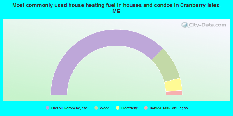
- 75.0%Fuel oil, kerosene, etc.
- 16.7%Wood
- 6.2%Electricity
- 2.1%Bottled, tank, or LP gas
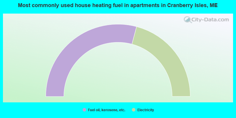
- 58.3%Fuel oil, kerosene, etc.
- 41.7%Electricity
Cranberry Isles compared to Maine state average:
- Median house value above state average.
- Unemployed percentage significantly below state average.
- Black race population percentage below state average.
- Median age above state average.
- Foreign-born population percentage significantly below state average.
- Renting percentage below state average.
- Length of stay since moving in significantly above state average.
- Number of rooms per house significantly below state average.
- House age significantly below state average.
- Number of college students below state average.

|
Total of 1 patent application in 2008-2024.