Cutshin, Kentucky
Submit your own pictures of this place and show them to the world
- OSM Map
- General Map
- Google Map
- MSN Map

| Males: 1,608 | |
| Females: 1,639 |
| Median resident age: | 36.0 years |
| Kentucky median age: | 35.9 years |
Zip code: 41764
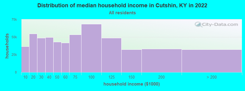
| Cutshin: | $39,526 |
| KY: | $59,341 |
Estimated per capita income in 2022: $19,965 (it was $10,959 in 2000)
Cutshin CCD income, earnings, and wages data
Estimated median house or condo value in 2022: $77,726 (it was $26,900 in 2000)
| Cutshin: | $77,726 |
| KY: | $196,300 |
Mean prices in 2022: all housing units: $90,456; detached houses: $104,915; mobile homes: $58,533
Detailed information about poverty and poor residents in Cutshin, KY
Compare current foreclosures near Cutshin, KY:
| Photo | Address | Area | Beds / Baths | Price | Details |
|---|---|---|---|---|---|

|
#1
W Highway 550
Hazard, KY 41701
|
- sq. feet
|
- baths - beds |
$8,000
|
show details |

|
#2
Pecan St
Hazard, KY 41701
|
2,411 sq. feet
|
2 baths 3 beds |
show details | |

|
#3
Big Fork Rd
Yeaddiss, KY 41777
|
768 sq. feet
|
1 baths 3 beds |
show details | |

|
#4
Yellow Creek Rd
Sassafras, KY 41759
|
1,228 sq. feet
|
1 baths 2 beds |
show details | |

|
#5
John Blood Holw
Busy, KY 41723
|
1,500 sq. feet
|
1 baths 3 beds |
show details | |

|
#6
Echo Ln
Thousandsticks, KY 41766
|
1,232 sq. feet
|
1 baths 3 beds |
show details | |

|
#7
Impala Dr
Busy, KY 41723
|
1,344 sq. feet
|
1 baths 3 beds |
show details | |

|
#8
Begley Ct # 3
Hazard, KY 41701
|
1,792 sq. feet
|
2 baths 3 beds |
show details | |

|
#9
River Rd
Hyden, KY 41749
|
1,596 sq. feet
|
1 baths 3 beds |
show details | |

|
#10
Highway 406
Stinnett, KY 40868
|
960 sq. feet
|
1 baths 3 beds |
show details |
| Photo | Address | Area | Beds / Baths | Price | Details |
|---|---|---|---|---|---|

|
#11
Daley Rd
Smilax, KY 41764
|
1,252 sq. feet
|
1 baths 3 beds |
show details | |

|
#12
Whitaker Fork Rd
Hazard, KY 41701
|
1,080 sq. feet
|
2 baths 3 beds |
show details | |

|
#13
Hazelnut Dr
Yeaddiss, KY 41777
|
1,680 sq. feet
|
1 baths 4 beds |
show details | |

|
#14
Peppermint Dr
Hyden, KY 41749
|
608 sq. feet
|
1 baths 1 beds |
show details | |

|
#15
Peters Branch Rd
Yeaddiss, KY 41777
|
1,056 sq. feet
|
1 baths 3 beds |
show details | |

|
#16
Heavenly Dr
Wendover, KY 41775
|
2,520 sq. feet
|
3 baths 3 beds |
show details | |

|
#17
Railroad Ct
Hazard, KY 41701
|
- sq. feet
|
1 baths 2 beds |
show details | |

|
#18
N Main St
Hazard, KY 41701
|
1,664 sq. feet
|
- baths - beds |
show details | |

|
#19
Moore St
Hazard, KY 41701
|
- sq. feet
|
1 baths 4 beds |
show details | |

|
#20
Upper River Rd
Viper, KY 41774
|
- sq. feet
|
1 baths 4 beds |
show details |
| Photo | Address | Area | Beds / Baths | Price | Details |
|---|---|---|---|---|---|

|
#21
Orchard Heights Rd
Hazard, KY 41701
|
- sq. feet
|
1 baths 3 beds |
show details | |

|
#22
Gorman Hollow Rd Apt 211
Hazard, KY 41701
|
- sq. feet
|
- baths - beds |
show details | |

|
#23
Beech Bottom Rd
Wooton, KY 41776
|
- sq. feet
|
- baths - beds |
show details | |

|
#24
Goldenrod Ln
Vicco, KY 41773
|
- sq. feet
|
- baths - beds |
show details | |

|
#25
Elk Fork Rd
Hazard, KY 41701
|
500 sq. feet
|
- baths - beds |
show details | |

|
#26
Ky Highway 463
Delphia, KY 41735
|
- sq. feet
|
- baths - beds |
show details | |

|
#27
Jakes Fork Rd
Bulan, KY 41722
|
- sq. feet
|
- baths - beds |
show details | |

|
#28
Hull School Rd
Hazard, KY 41701
|
1,120 sq. feet
|
- baths - beds |
show details | |

|
#29
Krypton Napfor Rd
Krypton, KY 41754
|
- sq. feet
|
- baths - beds |
show details | |

|
#30
Couch Dr
Cornettsville, KY 41731
|
- sq. feet
|
- baths - beds |
show details |
| Photo | Address | Area | Beds / Baths | Price | Details |
|---|---|---|---|---|---|

|
#31
Lotts Creek Rd
Hazard, KY 41701
|
- sq. feet
|
- baths - beds |
show details | |

|
#32
Campbell Town Rd
Cornettsville, KY 41731
|
- sq. feet
|
- baths - beds |
show details | |

|
#33
Montgomery Creek Rd
Vicco, KY 41773
|
- sq. feet
|
- baths - beds |
show details | |

|
#34
N Ky Highway 15
Hazard, KY 41701
|
1,200 sq. feet
|
- baths - beds |
show details | |

|
#35
Big Jakes Br
Gordon, KY 41819
|
- sq. feet
|
- baths - beds |
show details | |

|
#36
Bull Skin Road
Hyden, KY 41749
|
- sq. feet
|
- baths - beds |
show details | |

|
#37
Highway 1103
Hallie, KY 41821
|
- sq. feet
|
- baths - beds |
show details | |

|
#38
Elma Ln
Hazard, KY 41701
|
- sq. feet
|
- baths - beds |
show details | |

|
#39
Shady Pine Ln
Hazard, KY 41701
|
- sq. feet
|
- baths - beds |
show details | |

|
#40
Merida Hollow Rd
Sizerock, KY 41762
|
- sq. feet
|
- baths - beds |
show details |
| Photo | Address | Area | Beds / Baths | Price | Details |
|---|---|---|---|---|---|

|
#41
Old Dixon Rd
Blackey, KY 41804
|
- sq. feet
|
- baths - beds |
show details | |

|
#42
N Ky Highway 15
Hazard, KY 41701
|
- sq. feet
|
- baths - beds |
show details | |

|
#43
Picnic Area Ln
Buckhorn, KY 41721
|
- sq. feet
|
- baths - beds |
show details | |

|
#44
Highway 721
Hazard, KY 41701
|
- sq. feet
|
- baths - beds |
show details | |

|
#45
Highway 522
Totz, KY 40870
|
- sq. feet
|
- baths - beds |
show details | |

|
#46
Pigeonroost Rd
Ary, KY 41712
|
- sq. feet
|
- baths - beds |
show details | |

|
#47
Ky Highway 28
Chavies, KY 41727
|
- sq. feet
|
- baths - beds |
show details | |

|
#48
Lost Creek Rd
Hazard, KY 41701
|
- sq. feet
|
- baths - beds |
show details | |

|
#49
Desiree Ln
Hazard, KY 41701
|
- sq. feet
|
- baths - beds |
show details | |

|
Check over 1 million property listings on Foreclosure.com!
|
browse all offers | |||

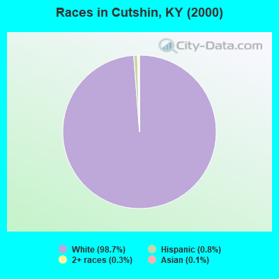
- 3,38798.7%White alone
- 260.8%Hispanic
- 120.3%Two or more races
- 50.1%Asian alone
- 30.09%American Indian alone
Races in Cutshin detailed stats: ancestries, foreign born residents, place of birth
 Recent articles from our blog. Our writers, many of them Ph.D. graduates or candidates, create easy-to-read articles on a wide variety of topics.
Current Local Time: EST time zone
Land area: 83.7 square miles.
Population density: 39 people per square mile (very low).

| Cutshin CCD: | 0.9% ($236) |
| Kentucky: | 0.8% ($610) |
Nearest city with pop. 50,000+: Johnson City, TN  (74.2 miles , pop. 55,469).
Nearest city with pop. 200,000+: Fayette, KY (91.4 miles , pop. 260,512).
Nearest city with pop. 1,000,000+: Chicago, IL (401.7 miles , pop. 2,896,016).
Nearest cities:
), ), ), ), ), )Latitude: 37.13 N, Longitude: 83.27 W
Area code commonly used in this area: 606

| Here: | 6.4% |
| Kentucky: | 3.8% |
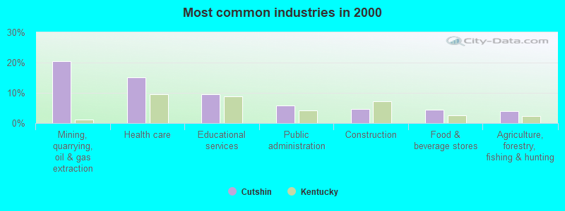
- Mining, quarrying, oil & gas extraction (20.5%)
- Health care (15.0%)
- Educational services (9.5%)
- Public administration (5.9%)
- Construction (4.7%)
- Food & beverage stores (4.4%)
- Agriculture, forestry, fishing & hunting (3.9%)
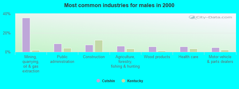
- Mining, quarrying, oil & gas extraction (35.8%)
- Public administration (8.6%)
- Construction (7.5%)
- Agriculture, forestry, fishing & hunting (6.1%)
- Wood products (5.7%)
- Health care (5.5%)
- Motor vehicle & parts dealers (4.8%)
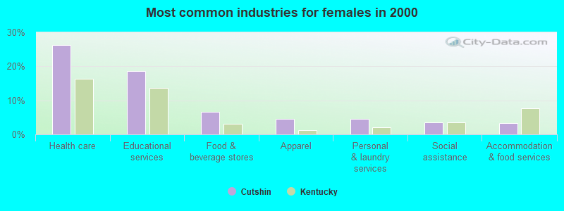
- Health care (26.2%)
- Educational services (18.7%)
- Food & beverage stores (6.7%)
- Apparel (4.6%)
- Personal & laundry services (4.6%)
- Social assistance (3.5%)
- Accommodation & food services (3.3%)
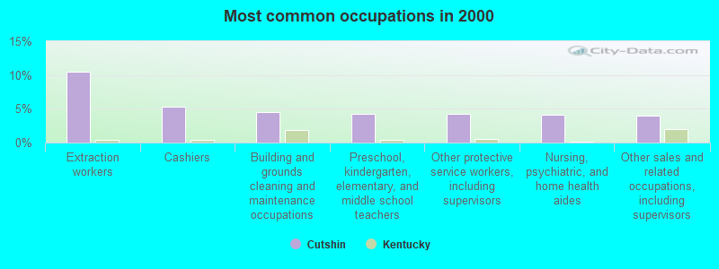
- Extraction workers (10.5%)
- Cashiers (5.4%)
- Building and grounds cleaning and maintenance occupations (4.5%)
- Preschool, kindergarten, elementary, and middle school teachers (4.3%)
- Other protective service workers, including supervisors (4.3%)
- Nursing, psychiatric, and home health aides (4.2%)
- Other sales and related occupations, including supervisors (4.0%)
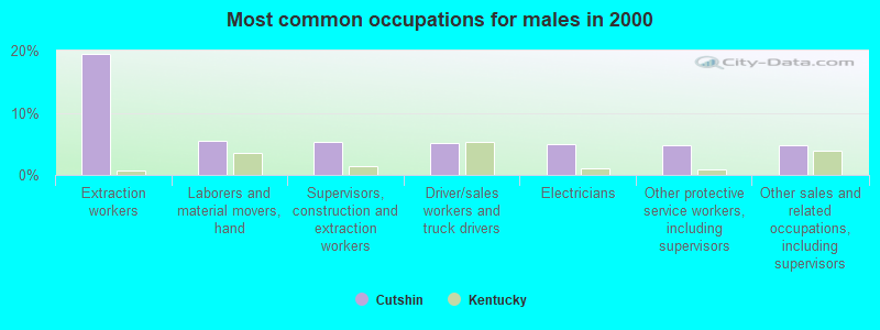
- Extraction workers (19.4%)
- Laborers and material movers, hand (5.5%)
- Supervisors, construction and extraction workers (5.3%)
- Driver/sales workers and truck drivers (5.1%)
- Electricians (5.0%)
- Other protective service workers, including supervisors (4.8%)
- Other sales and related occupations, including supervisors (4.8%)
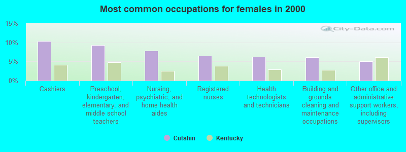
- Cashiers (10.4%)
- Preschool, kindergarten, elementary, and middle school teachers (9.3%)
- Nursing, psychiatric, and home health aides (7.8%)
- Registered nurses (6.5%)
- Health technologists and technicians (6.3%)
- Building and grounds cleaning and maintenance occupations (6.1%)
- Other office and administrative support workers, including supervisors (5.0%)
Average climate in Cutshin, Kentucky
Based on data reported by over 4,000 weather stations


(lower is better)
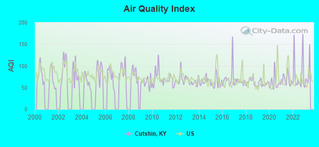
Air Quality Index (AQI) level in 2022 was 81.6. This is about average.
| City: | 81.6 |
| U.S.: | 72.6 |
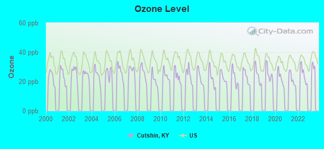
Ozone [ppb] level in 2022 was 24.9. This is better than average. Closest monitor was 8.9 miles away from the city center.
| City: | 24.9 |
| U.S.: | 33.3 |
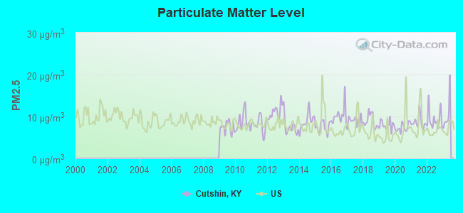
Particulate Matter (PM2.5) [µg/m3] level in 2022 was 9.26. This is about average. Closest monitor was 10.8 miles away from the city center.
| City: | 9.26 |
| U.S.: | 8.11 |
Tornado activity:
Cutshin-area historical tornado activity is significantly below Kentucky state average. It is 59% smaller than the overall U.S. average.
On 5/9/1988, a category F3 (max. wind speeds 158-206 mph) tornado 42.6 miles away from the Cutshin place center killed one person and injured 15 people and caused between $5,000,000 and $50,000,000 in damages.
On 5/18/1995, a category F2 (max. wind speeds 113-157 mph) tornado 18.1 miles away from the place center caused between $50,000 and $500,000 in damages.
Earthquake activity:
Cutshin-area historical earthquake activity is significantly above Kentucky state average. It is 46% greater than the overall U.S. average.On 7/27/1980 at 18:52:21, a magnitude 5.2 (5.1 MB, 4.7 MS, 5.0 UK, 5.2 UK, Class: Moderate, Intensity: VI - VII) earthquake occurred 82.8 miles away from Cutshin center
On 8/9/2020 at 12:07:37, a magnitude 5.1 (5.1 MW, Depth: 4.7 mi) earthquake occurred 128.7 miles away from the city center
On 8/23/2011 at 17:51:04, a magnitude 5.8 (5.8 MW, Depth: 3.7 mi) earthquake occurred 297.3 miles away from the city center
On 9/7/1988 at 02:28:09, a magnitude 4.6 (4.5 MB, 4.6 LG, Class: Light, Intensity: IV - V) earthquake occurred 77.4 miles away from the city center
On 11/30/1973 at 07:48:41, a magnitude 4.7 (4.7 MB, 4.6 ML) earthquake occurred 100.1 miles away from the city center
On 11/10/2012 at 17:08:14, a magnitude 4.2 (4.2 MW, Depth: 10.6 mi) earthquake occurred 11.8 miles away from Cutshin center
Magnitude types: regional Lg-wave magnitude (LG), body-wave magnitude (MB), local magnitude (ML), surface-wave magnitude (MS), moment magnitude (MW)
Natural disasters:
The number of natural disasters in Leslie County (28) is a lot greater than the US average (15).Major Disasters (Presidential) Declared: 21
Emergencies Declared: 2
Causes of natural disasters: Floods: 21, Storms: 18, Mudslides: 10, Tornadoes: 7, Landslides: 5, Winds: 3, Winter Storms: 3, Fires: 2, Blizzard: 1, Hurricane: 1, Snow: 1, Snowfall: 1, Snowstorm: 1, Other: 1 (Note: some incidents may be assigned to more than one category).
Hospitals and medical centers near Cutshin:
- MARY BRECKINRIDGE HOME HEALTH AGENCY (Home Health Center, about 7 miles away; HYDEN, KY)
- MARY BRECKINRIDGE ARH HOSPITAL Critical Access Hospitals (about 7 miles away; HYDEN, KY)
- MOUNTAIN COMMUNITY HOSPICE (Hospital, about 11 miles away; HAZARD, KY)
- HAZARD HEALTH AND REHABILITATION CENTER (Nursing Home, about 11 miles away; HAZARD, KY)
Colleges/universities with over 2000 students nearest to Cutshin:
- Hazard Community and Technical College (about 9 miles; Hazard, KY; Full-time enrollment: 2,087)
- Southeast Kentucky Community and Technical College (about 19 miles; Cumberland, KY; FT enrollment: 2,196)
- Lincoln Memorial University (about 44 miles; Harrogate, TN; FT enrollment: 3,706)
- Big Sandy Community and Technical College (about 47 miles; Prestonsburg, KY; FT enrollment: 2,660)
- University of the Cumberlands (about 57 miles; Williamsburg, KY; FT enrollment: 3,585)
- Walters State Community College (about 64 miles; Morristown, TN; FT enrollment: 4,359)
- Northeast State Community College (about 66 miles; Blountville, TN; FT enrollment: 4,480)
Points of interest:
Notable locations in Cutshin: Cutshin Volunteer Fire and Rescue Station 3 (A), Coon Creek Volunteer Fire Department (B), Cutshin Volunteer Fire and Rescue Station 1 (C), Wooten Fire and Rescue (D), Cutshin Volunteer Fire Department Station 2 (E). Display/hide their locations on the map
Churches in Cutshin include: Brown Chapel (A), Big Fork Church (B), Saw Branch Church (C), Solid Rock Bible Church (D), Cutship Church (E). Display/hide their locations on the map
Cemeteries: Hendrix Cemetery (1), Dixon Cemetery (2), Days Cemetery (3), Creech Cemetery (4), Raccoon Cemetery (5). Display/hide their locations on the map
Streams, rivers, and creeks: Camp Branch (A), Cane Branch (B), Caudill Fork (C), Collins Branch (D), Cowhead Branch (E), Deep Ford Branch (F), Dicks Branch (G), Dixon Branch (H), Double Rock Branch (I). Display/hide their locations on the map
| This place: | 2.4 people |
| Kentucky: | 2.5 people |
| This place: | 70.4% |
| Whole state: | 66.9% |
| This place: | 4.8% |
| Whole state: | 6.4% |
Likely homosexual households (counted as self-reported same-sex unmarried-partner households)
- Lesbian couples: 0.2% of all households
- Gay men: 0.4% of all households
| This place: | 28.8% |
| Whole state: | 15.8% |
| This place: | 14.1% |
| Whole state: | 6.6% |
For population 15 years and over in Cutshin:
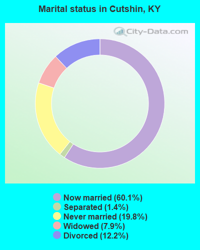
- Never married: 19.8%
- Now married: 60.1%
- Separated: 1.4%
- Widowed: 7.9%
- Divorced: 12.2%
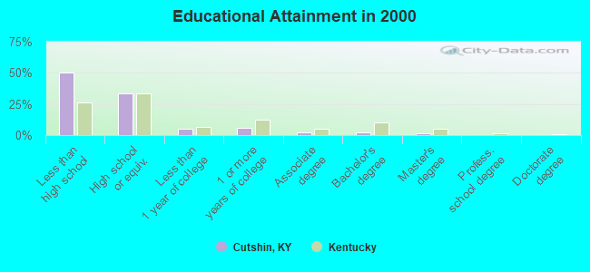
For population 25 years and over in Cutshin:
- High school or higher: 50.0%
- Bachelor's degree or higher: 3.8%
- Graduate or professional degree: 1.7%
- Unemployed: 8.9%
- Mean travel time to work (commute): 41.0 minutes

| Here: | 17.2 |
| Kentucky average: | 13.8 |
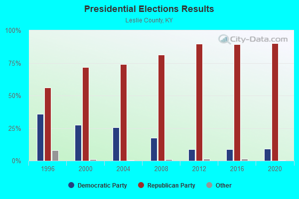
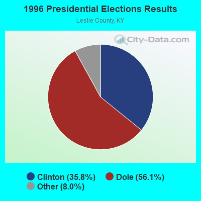
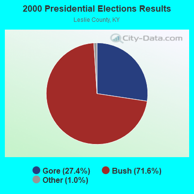
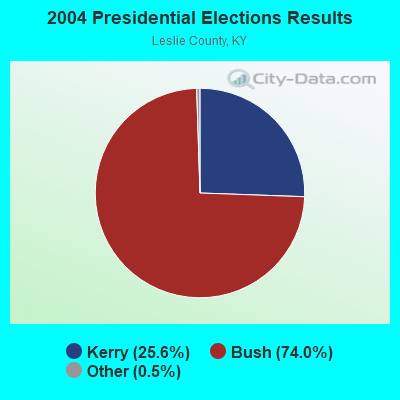
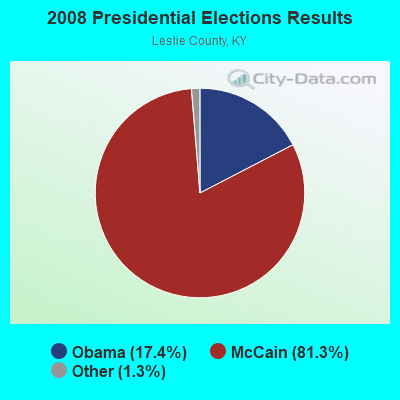
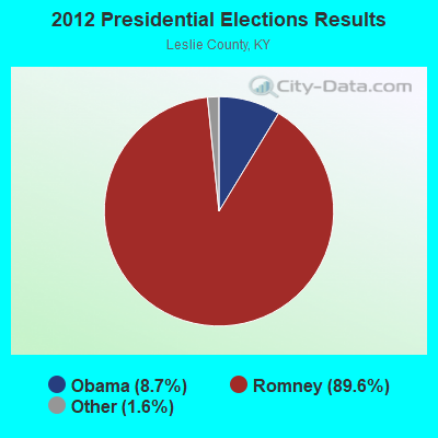
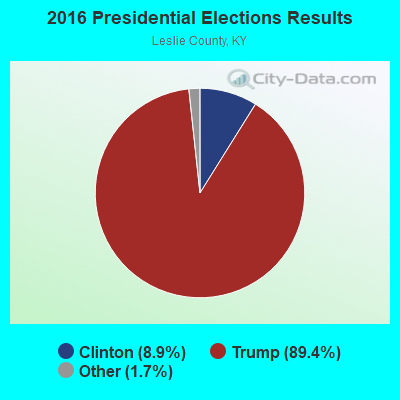
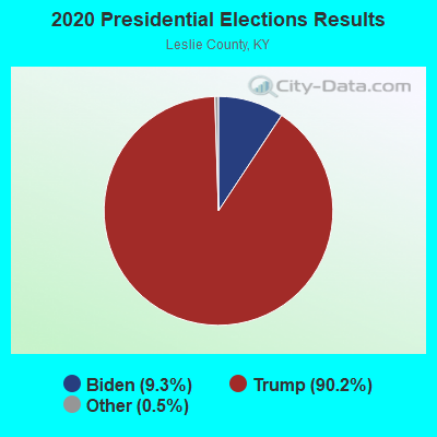
Graphs represent county-level data. Detailed 2008 Election Results
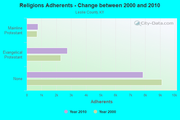
Religion statistics for Cutshin, KY (based on Leslie County data)
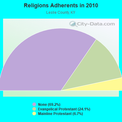
| Religion | Adherents | Congregations |
|---|---|---|
| Evangelical Protestant | 2,724 | 18 |
| Mainline Protestant | 757 | 9 |
| None | 7,829 | - |
Food Environment Statistics:
| Leslie County: | 5.11 / 10,000 pop. |
| Kentucky: | 2.19 / 10,000 pop. |
| Leslie County: | 1.70 / 10,000 pop. |
| Kentucky: | 0.74 / 10,000 pop. |
| This county: | 3.41 / 10,000 pop. |
| Kentucky: | 4.36 / 10,000 pop. |
| Leslie County: | 13.6% |
| Kentucky: | 11.0% |
| Leslie County: | 34.3% |
| Kentucky: | 30.0% |
| This county: | 12.9% |
| State: | 15.9% |
Strongest AM radio stations in Cutshin:
- WKIC (1390 AM; 5 kW; HAZARD, KY)
- WFSR (970 AM; 5 kW; HARLAN, KY; Owner: EASTERN BROADCASTING COMPAY)
- WHLN (1410 AM; 5 kW; HARLAN, KY)
- WKVL (850 AM; daytime; 50 kW; KNOXVILLE, TN; Owner: HORNE RADIO, LLC)
- WEKG (810 AM; daytime; 5 kW; JACKSON, KY; Owner: INTERMOUNTAIN B/CING CO., INC.)
- WTCW (920 AM; 4 kW; WHITESBURG, KY; Owner: T.C.W. BROADCASTING , INC.)
- WQXY (1560 AM; daytime; 1 kW; HAZARD, KY; Owner: BLACK GOLD BROADCASTING)
- WMTC (730 AM; 5 kW; VANCLEVE, KY; Owner: THE KENTUCKY MOUNTAIN HOLINESS ASSN.)
- WKLB (1290 AM; 5 kW; MANCHESTER, KY; Owner: BARKER BROADCASTING COMPANY, INC.)
- WGOC (640 AM; 10 kW; BLOUNTVILLE, TN; Owner: CITADEL BROADCASTING COMPANY)
- WEZC (1480 AM; daytime; 5 kW; NEON, KY; Owner: JESUS COMMUNICATION ILNC.)
- WFGW (1010 AM; 50 kW; BLACK MOUNTAIN, NC; Owner: BLUE RIDGE BROADCASTING CORP.)
- WLSI (900 AM; 5 kW; PIKEVILLE, KY; Owner: EAST KENTUCKY BROADCASTING CORPORATION)
Strongest FM radio stations in Cutshin:
- WSGS (101.1 FM; HAZARD, KY; Owner: MOUNTAIN BROADCASTING SERVICE, INC.)
- WEKH (90.9 FM; HAZARD, KY; Owner: EASTERN KENTUCKY UNIVERSITY)
- WJMD (104.7 FM; HAZARD, KY; Owner: HAZARD BROADCASTING SERVICES)
- WZQQ (97.9 FM; HYDEN, KY; Owner: LESLIE COUNTY BROADCASTING, INC.)
- WSEH (102.7 FM; CUMBERLAND, KY; Owner: CUMBERLAND CITY BROADCASTING, INC.)
- WTUK (105.1 FM; HARLAN, KY; Owner: EASTERN BROADCASTING COMPANY)
- WAXM (93.5 FM; BIG STONE GAP, VA; Owner: VALLEY BROADCASTING, INC.)
- WIFX-FM (94.3 FM; JENKINS, KY; Owner: LETCHER COUNTY BROADCASTING, INC)
- WXKQ-FM (103.9 FM; WHITESBURG, KY; Owner: T.C.W. BROADCASTING , INC.)
- WMMT (88.7 FM; WHITESBURG, KY; Owner: APPALSHOP, INCORPORATED)
- W223AA (92.5 FM; BIG STONE GAP, VA; Owner: VALLEY BROADCASTING, INC.)
- WDXC (102.3 FM; POUND, VA; Owner: WDXC RADIO, INC.)
- WTFM (98.5 FM; KINGSPORT, TN; Owner: HOLSTON VALLEY BROADCASTING CORP.)
- WKCB-FM (107.1 FM; HINDMAN, KY; Owner: HINDMAN BROADCASTING CORPORATION)
- WJSN-FM (106.5 FM; JACKSON, KY; Owner: INTERMOUNTAIN BROADCASTING CO.)
- WMIK-FM (92.7 FM; MIDDLESBORO, KY; Owner: GATEWAY BROADCASTING, INC.)
- WJDT (106.5 FM; ROGERSVILLE, TN; Owner: C & S BROADCASTING)
- WPKE-FM (103.1 FM; COAL RUN, KY; Owner: EAST KENTUCKY BROADCASTING CORP.)
- WTBK (105.7 FM; MANCHESTER, KY; Owner: MANCHESTER COMMUNICATIONS, INC.)
- WWJD (91.7 FM; PIPPA PASSES, KY; Owner: ALICE LLOYD COLLEGE)
TV broadcast stations around Cutshin:
- WYMT-TV (Channel 57; HAZARD, KY; Owner: WYMT LICENSEE CORP.)
- W24BT (Channel 24; TALBERT, KY; Owner: MS COMMUNICATIONS, LLC)
- WKHA (Channel 35; HAZARD, KY; Owner: KENTUCKY AUTHORITY FOR EDUCATIONAL TV)
- W31BU (Channel 31; TALBERT, KY; Owner: MS COMMUNICATIONS, LLC)
- W53BQ (Channel 53; TALBERT, KY; Owner: MS COMMUNICATIONS, LLC)
- W69ED (Channel 69; TALBERT, KY; Owner: MS COMMUNICATIONS, LLC)
- W26BK (Channel 26; TALBERT, KY; Owner: MS COMMUNICATIONS, LLC)
- W16BI (Channel 16; TALBERT, KY; Owner: MS COMMUNICATIONS, LLC)
- W20BO (Channel 20; TALBERT, KY; Owner: MS COMMUNICATIONS, LLC)
- WLJC-TV (Channel 65; BEATTYVILLE, KY; Owner: HOUR OF HARVEST, INC.)
- WAGV (Channel 44; HARLAN, KY; Owner: LIVING FAITH MINISTRIES, INC.)
- W64CM (Channel 64; TALBERT, KY; Owner: MS COMMUNICATIONS, LLC)
- W66DA (Channel 66; TALBERT, KY; Owner: MS COMMUNICATIONS, LLC)
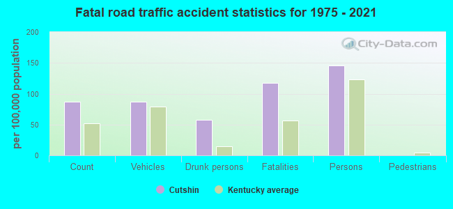
Cutshin fatal accident list:
Oct 24, 2010 09:00 AM, Beech Bottom Rd, Lat: 37.092772, Lon: -83.257483, Vehicles: 1, Persons: 1, Fatalities: 1, Drunk persons involved: 1
Jun 26, 2004 04:44 AM, Sr-699, Vehicles: 1, Persons: 3, Fatalities: 2, Drunk persons involved: 1
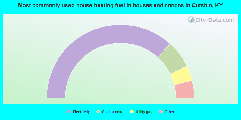
- 73.5%Electricity
- 12.2%Coal or coke
- 6.6%Utility gas
- 3.7%Wood
- 2.9%Fuel oil, kerosene, etc.
- 1.1%Bottled, tank, or LP gas
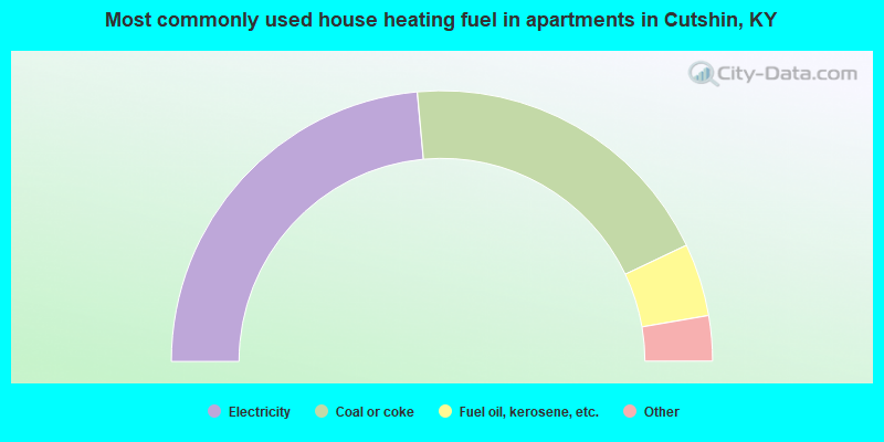
- 47.1%Electricity
- 38.8%Coal or coke
- 8.7%Fuel oil, kerosene, etc.
- 3.3%Bottled, tank, or LP gas
- 2.1%Utility gas
Cutshin compared to Kentucky state average:
- Median household income below state average.
- Median house value significantly below state average.
- Black race population percentage significantly below state average.
- Hispanic race population percentage significantly below state average.
- Median age below state average.
- Foreign-born population percentage significantly below state average.
- Renting percentage below state average.
- Length of stay since moving in significantly above state average.
- Number of rooms per house significantly below state average.
- House age significantly below state average.
- Number of college students below state average.
- Percentage of population with a bachelor's degree or higher significantly below state average.