Deerfield, New Hampshire
Submit your own pictures of this town and show them to the world
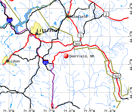
- OSM Map
- General Map
- Google Map
- MSN Map
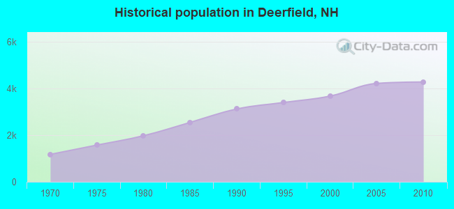
Population change since 2000: +16.4%
 |
| Males: 2,110 | |
| Females: 2,170 |
| Median resident age: | 42.0 years |
| New Hampshire median age: | 43.9 years |
Zip codes: 03037.
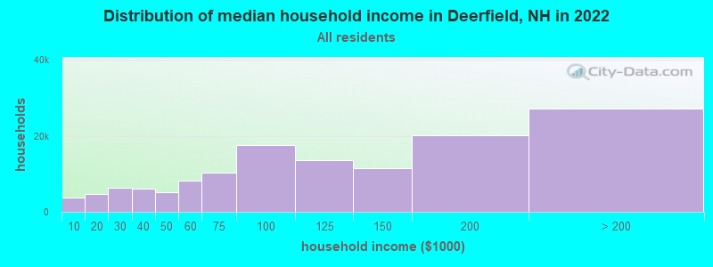
| Deerfield: | $113,386 |
| NH: | $89,992 |
Estimated per capita income in 2022: $53,034 (it was $24,160 in 2000)
Deerfield town income, earnings, and wages data
Estimated median house or condo value in 2022: $458,033 (it was $149,900 in 2000)
| Deerfield: | $458,033 |
| NH: | $384,700 |
Mean prices in 2022: all housing units: $614,227; detached houses: $665,470; townhouses or other attached units: $408,866; in 2-unit structures: $730,084; in 3-to-4-unit structures: over $1,000,000; in 5-or-more-unit structures: $329,099; mobile homes: $126,160
Detailed information about poverty and poor residents in Deerfield, NH


- 4,18197.7%White alone
- 431.0%Two or more races
- 250.6%Hispanic
- 140.3%Asian alone
- 100.2%Black alone
- 40.09%American Indian alone
- 30.07%Other race alone
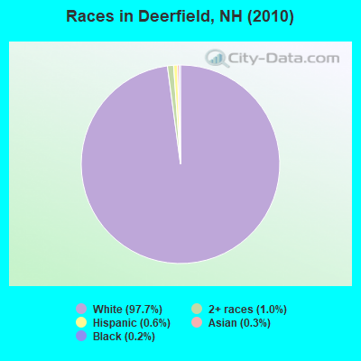
Races in Deerfield detailed stats: ancestries, foreign born residents, place of birth
According to our research of New Hampshire and other state lists, there were 10 registered sex offenders living in Deerfield, New Hampshire as of April 24, 2024.
The ratio of all residents to sex offenders in Deerfield is 428 to 1.
The ratio of registered sex offenders to all residents in this city is near the state average.
Type |
2009 |
2010 |
2011 |
2012 |
2013 |
2014 |
2015 |
2016 |
2017 |
2018 |
2019 |
2020 |
2021 |
2022 |
|---|---|---|---|---|---|---|---|---|---|---|---|---|---|---|
| Murders (per 100,000) | 0 (0.0) | 0 (0.0) | 1 (23.3) | 0 (0.0) | 0 (0.0) | 0 (0.0) | 0 (0.0) | 0 (0.0) | 0 (0.0) | 0 (0.0) | 0 (0.0) | 0 (0.0) | 0 (0.0) | 0 (0.0) |
| Rapes (per 100,000) | 1 (23.5) | 1 (23.4) | 0 (0.0) | 1 (23.2) | 1 (22.9) | 3 (68.4) | 3 (67.9) | 0 (0.0) | 1 (22.4) | 0 (0.0) | 1 (21.9) | 0 (0.0) | 0 (0.0) | 2 (40.5) |
| Robberies (per 100,000) | 0 (0.0) | 0 (0.0) | 1 (23.3) | 0 (0.0) | 0 (0.0) | 1 (22.8) | 0 (0.0) | 0 (0.0) | 0 (0.0) | 0 (0.0) | 0 (0.0) | 0 (0.0) | 0 (0.0) | 0 (0.0) |
| Assaults (per 100,000) | 0 (0.0) | 6 (140.2) | 0 (0.0) | 0 (0.0) | 2 (45.9) | 2 (45.6) | 5 (113.1) | 0 (0.0) | 3 (67.2) | 3 (66.1) | 0 (0.0) | 1 (21.9) | 0 (0.0) | 1 (20.3) |
| Burglaries (per 100,000) | 7 (164.3) | 26 (607.5) | 28 (653.3) | 13 (302.1) | 7 (160.5) | 11 (250.9) | 10 (226.2) | 15 (338.1) | 6 (134.4) | 4 (88.2) | 6 (131.5) | 1 (21.9) | 1 (21.5) | 0 (0.0) |
| Thefts (per 100,000) | 37 (868.3) | 47 (1,098) | 50 (1,167) | 41 (952.8) | 39 (894.1) | 30 (684.3) | 26 (588.2) | 14 (315.6) | 9 (201.6) | 27 (595.2) | 11 (241.1) | 11 (240.4) | 18 (386.9) | 20 (405.4) |
| Auto thefts (per 100,000) | 2 (46.9) | 4 (93.5) | 4 (93.3) | 0 (0.0) | 5 (114.6) | 2 (45.6) | 1 (22.6) | 0 (0.0) | 6 (134.4) | 2 (44.1) | 0 (0.0) | 0 (0.0) | 2 (43.0) | 0 (0.0) |
| Arson (per 100,000) | 0 (0.0) | 0 (0.0) | 2 (46.7) | 0 (0.0) | 0 (0.0) | 0 (0.0) | 0 (0.0) | 1 (22.5) | 0 (0.0) | 0 (0.0) | 0 (0.0) | 0 (0.0) | 0 (0.0) | 0 (0.0) |
| City-Data.com crime index | 68.8 | 140.7 | 153.5 | 77.9 | 83.7 | 119.3 | 118.1 | 36.3 | 59.6 | 46.7 | 36.4 | 15.5 | 20.4 | 52.7 |
The City-Data.com crime index weighs serious crimes and violent crimes more heavily. Higher means more crime, U.S. average is 246.1. It adjusts for the number of visitors and daily workers commuting into cities.
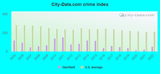
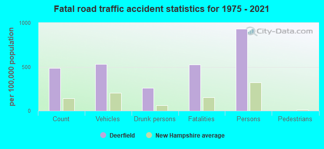
Crime rate in Deerfield detailed stats: murders, rapes, robberies, assaults, burglaries, thefts, arson
Full-time law enforcement employees in 2021, including police officers: 9 (8 officers - 8 male; 0 female).
| Officers per 1,000 residents here: | 1.72 |
| New Hampshire average: | 2.14 |
 Recent articles from our blog. Our writers, many of them Ph.D. graduates or candidates, create easy-to-read articles on a wide variety of topics.

 | New Hampshire is on my short list of locations to move to from Montana (42 replies) |
| Most overrated food establishments in NH (45 replies) |
| So how long did you sit in traffic to get into the Deerfield Fair (8 replies) |
| How are Things Looking for Scott Brown? (170 replies) |
| Annual City/County Fair? (15 replies) |
| Leather Tailor in NH (8 replies) |
Latest news from Deerfield, NH collected exclusively by city-data.com from local newspapers, TV, and radio stations
Ancestries: English (19.9%), Irish (18.9%), French (12.4%), German (10.2%), French Canadian (9.8%), Italian (7.3%).
Current Local Time: EST time zone
Incorporated in 1766
Land area: 50.9 square miles.
Population density: 84 people per square mile (very low).
59 residents are foreign born
| This town: | 1.6% |
| New Hampshire: | 4.4% |
| Deerfield town: | 2.1% ($3,139) |
| New Hampshire: | 2.3% ($2,946) |
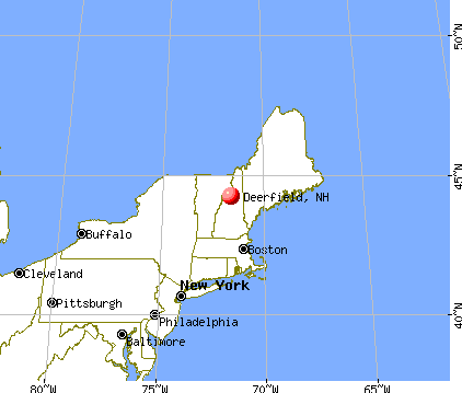
Nearest city with pop. 50,000+: Manchester, NH  (14.9 miles , pop. 107,006).
Nearest city with pop. 200,000+: Boston, MA (57.3 miles , pop. 589,141).
Nearest city with pop. 1,000,000+: Bronx, NY (208.3 miles , pop. 1,332,650).
Nearest cities:
), ), ), ), ), )Latitude: 43.14 N, Longitude: 71.25 W
Area code: 603

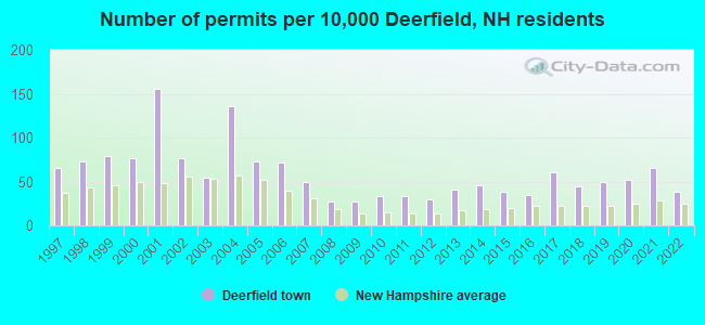
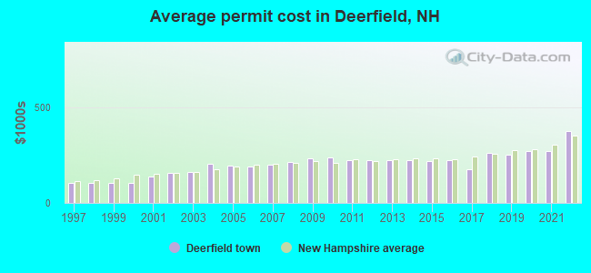
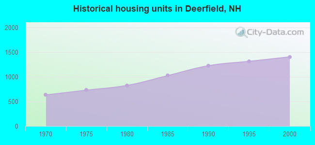
Single-family new house construction building permits:
- 2022: 14 buildings, average cost: $375,000
- 2021: 24 buildings, average cost: $270,000
- 2020: 19 buildings, average cost: $273,700
- 2019: 18 buildings, average cost: $250,600
- 2018: 16 buildings, average cost: $264,100
- 2017: 22 buildings, average cost: $178,000
- 2016: 13 buildings, average cost: $222,800
- 2015: 14 buildings, average cost: $221,400
- 2014: 17 buildings, average cost: $225,900
- 2013: 15 buildings, average cost: $225,900
- 2012: 11 buildings, average cost: $226,200
- 2011: 12 buildings, average cost: $224,800
- 2010: 12 buildings, average cost: $239,800
- 2009: 10 buildings, average cost: $233,000
- 2008: 10 buildings, average cost: $213,000
- 2007: 18 buildings, average cost: $201,600
- 2006: 26 buildings, average cost: $188,800
- 2005: 27 buildings, average cost: $194,100
- 2004: 50 buildings, average cost: $202,500
- 2003: 20 buildings, average cost: $161,600
- 2002: 28 buildings, average cost: $158,800
- 2001: 57 buildings, average cost: $138,900
- 2000: 28 buildings, average cost: $103,800
- 1999: 29 buildings, average cost: $103,800
- 1998: 27 buildings, average cost: $103,500
- 1997: 24 buildings, average cost: $105,200
| Here: | 2.1% |
| New Hampshire: | 2.5% |
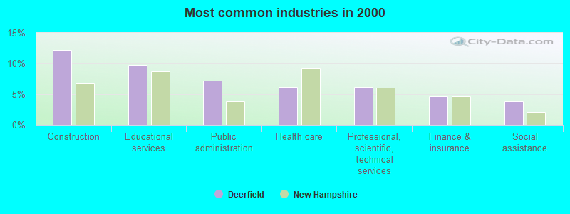
- Construction (12.2%)
- Educational services (9.7%)
- Public administration (7.3%)
- Health care (6.2%)
- Professional, scientific, technical services (6.1%)
- Finance & insurance (4.7%)
- Social assistance (3.8%)
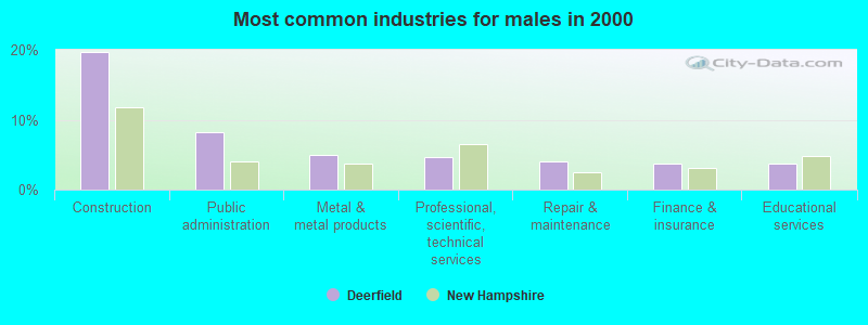
- Construction (19.7%)
- Public administration (8.2%)
- Metal & metal products (4.9%)
- Professional, scientific, technical services (4.7%)
- Repair & maintenance (4.1%)
- Finance & insurance (3.8%)
- Educational services (3.8%)
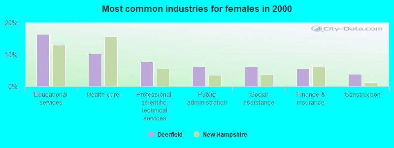
- Educational services (16.4%)
- Health care (10.2%)
- Professional, scientific, technical services (7.8%)
- Public administration (6.2%)
- Social assistance (6.2%)
- Finance & insurance (5.6%)
- Construction (3.9%)
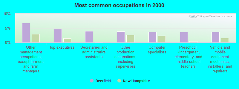
- Other management occupations, except farmers and farm managers (6.8%)
- Top executives (4.7%)
- Secretaries and administrative assistants (3.9%)
- Other production occupations, including supervisors (3.8%)
- Computer specialists (3.7%)
- Preschool, kindergarten, elementary, and middle school teachers (3.6%)
- Vehicle and mobile equipment mechanics, installers, and repairers (3.6%)
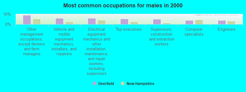
- Other management occupations, except farmers and farm managers (9.2%)
- Vehicle and mobile equipment mechanics, installers, and repairers (6.2%)
- Electrical equipment mechanics and other installation, maintenance, and repair workers, including supervisors (5.9%)
- Top executives (5.3%)
- Supervisors, construction and extraction workers (5.1%)
- Computer specialists (4.1%)
- Engineers (3.9%)
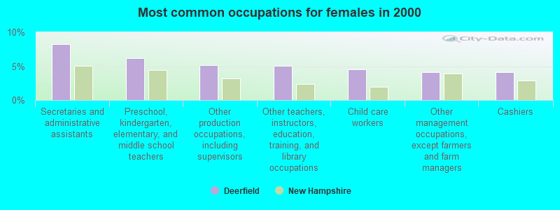
- Secretaries and administrative assistants (8.2%)
- Preschool, kindergarten, elementary, and middle school teachers (6.2%)
- Other production occupations, including supervisors (5.2%)
- Other teachers, instructors, education, training, and library occupations (5.1%)
- Child care workers (4.6%)
- Other management occupations, except farmers and farm managers (4.1%)
- Cashiers (4.1%)
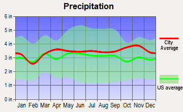
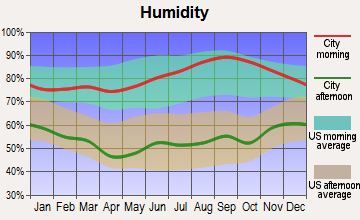
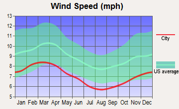
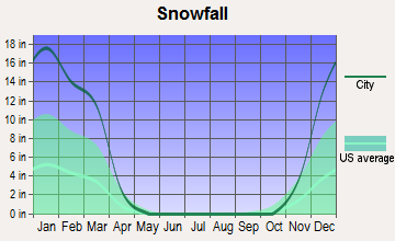
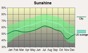
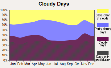
Average climate in Deerfield, New Hampshire
Based on data reported by over 4,000 weather stations

(lower is better)
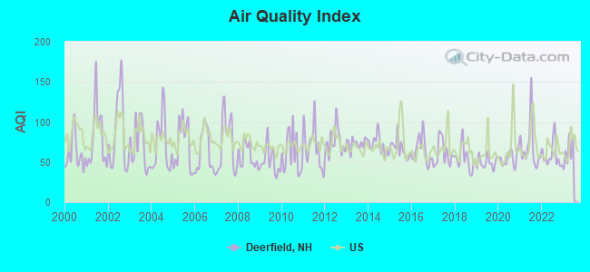
Air Quality Index (AQI) level in 2022 was 58.4. This is better than average.
| City: | 58.4 |
| U.S.: | 72.6 |
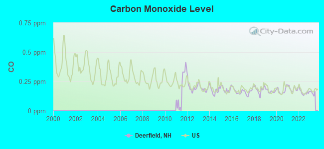
Carbon Monoxide (CO) [ppm] level in 2022 was 0.157. This is significantly better than average. Closest monitor was 14.8 miles away from the city center.
| City: | 0.157 |
| U.S.: | 0.251 |
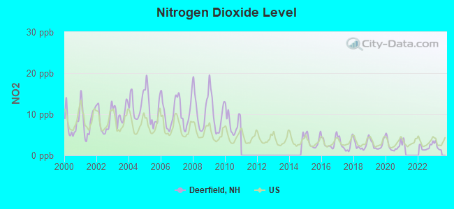
Nitrogen Dioxide (NO2) [ppb] level in 2022 was 2.05. This is significantly better than average. Closest monitor was 10.1 miles away from the city center.
| City: | 2.05 |
| U.S.: | 5.11 |
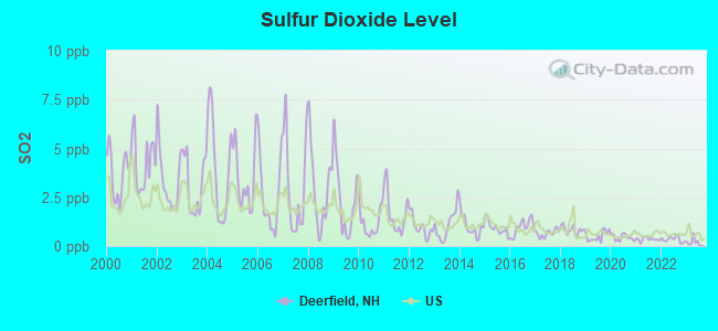
Sulfur Dioxide (SO2) [ppb] level in 2022 was 0.338. This is significantly better than average. Closest monitor was 10.2 miles away from the city center.
| City: | 0.338 |
| U.S.: | 1.515 |
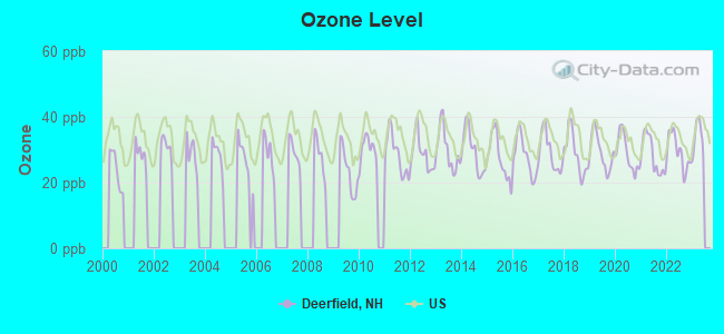
Ozone [ppb] level in 2022 was 29.3. This is about average. Closest monitor was 1.0 miles away from the city center.
| City: | 29.3 |
| U.S.: | 33.3 |
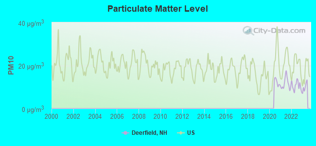
Particulate Matter (PM10) [µg/m3] level in 2022 was 10.6. This is significantly better than average. Closest monitor was 11.0 miles away from the city center.
| City: | 10.6 |
| U.S.: | 19.2 |
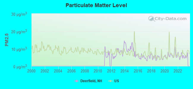
Particulate Matter (PM2.5) [µg/m3] level in 2022 was 5.71. This is significantly better than average. Closest monitor was 14.7 miles away from the city center.
| City: | 5.71 |
| U.S.: | 8.11 |
Tornado activity:
Deerfield-area historical tornado activity is slightly above New Hampshire state average. It is 47% smaller than the overall U.S. average.
On 6/9/1953, a category F3 (max. wind speeds 158-206 mph) tornado 18.4 miles away from the Deerfield town center injured 5 people and caused between $5000 and $50,000 in damages.
On 7/24/2008, a category F2 (max. wind speeds 113-157 mph) tornado 3.1 miles away from the town center killed one person and injured 2 people and caused $2 million in damages.
Earthquake activity:
Deerfield-area historical earthquake activity is significantly above New Hampshire state average. It is 72% smaller than the overall U.S. average.On 4/20/2002 at 10:50:47, a magnitude 5.3 (5.3 ML, Depth: 3.0 mi, Class: Moderate, Intensity: VI - VII) earthquake occurred 154.6 miles away from Deerfield center
On 1/19/1982 at 00:14:42, a magnitude 4.7 (4.5 MB, 4.7 MD, 4.5 LG, Class: Light, Intensity: IV - V) earthquake occurred 30.4 miles away from Deerfield center
On 10/7/1983 at 10:18:46, a magnitude 5.3 (5.1 MB, 5.3 LG, 5.1 ML) earthquake occurred 164.9 miles away from the city center
On 10/16/2012 at 23:12:25, a magnitude 4.7 (4.7 ML, Depth: 10.0 mi) earthquake occurred 43.4 miles away from the city center
On 4/20/2002 at 10:50:47, a magnitude 5.2 (5.2 MB, 4.2 MS, 5.2 MW, 5.0 MW) earthquake occurred 154.4 miles away from the city center
On 8/21/1996 at 07:54:14, a magnitude 3.8 (3.8 LG, 3.6 LG, Depth: 6.2 mi, Class: Light, Intensity: II - III) earthquake occurred 72.3 miles away from the city center
Magnitude types: regional Lg-wave magnitude (LG), body-wave magnitude (MB), duration magnitude (MD), local magnitude (ML), surface-wave magnitude (MS), moment magnitude (MW)
Natural disasters:
The number of natural disasters in Rockingham County (26) is a lot greater than the US average (15).Major Disasters (Presidential) Declared: 17
Emergencies Declared: 9
Causes of natural disasters: Storms: 12, Floods: 9, Winter Storms: 5, Hurricanes: 4, Snowstorms: 4, Snows: 2, Winds: 2, Blizzard: 1, Snowfall: 1, Tornado: 1 (Note: some incidents may be assigned to more than one category).
Hospitals and medical centers near Deerfield:
- EPSOM HEALTHCARE CENTER (Nursing Home, about 10 miles away; EPSOM, NH)
- COLONIAL POPLIN NURSING HOME (Nursing Home, about 13 miles away; FREMONT, NH)
- VILLA CREST (Nursing Home, about 14 miles away; MANCHESTER, NH)
- ROCKINGHAM COUNTY NURSING HOME (Nursing Home, about 14 miles away; BRENTWOOD, NH)
- LAKE SHORE HOSPITAL, INC (Hospital, about 14 miles away; MANCHESTER, NH)
- HACKETT HILL HEALTHCARE CENTER (Nursing Home, about 14 miles away; MANCHESTER, NH)
- ST JOSEPH RESIDENCE (Nursing Home, about 14 miles away; MANCHESTER, NH)
Heliports located in Deerfield:
Colleges/universities with over 2000 students nearest to Deerfield:
- Southern New Hampshire University (about 13 miles; Manchester, NH; Full-time enrollment: 16,552)
- NHTI-Concord's Community College (about 16 miles; Concord, NH; FT enrollment: 2,865)
- University of New Hampshire-Main Campus (about 16 miles; Durham, NH; FT enrollment: 15,243)
- Mount Washington College (about 17 miles; Manchester, NH; FT enrollment: 2,187)
- Saint Anselm College (about 18 miles; Manchester, NH; FT enrollment: 2,059)
- Northern Essex Community College (about 26 miles; Haverhill, MA; FT enrollment: 4,737)
- Merrimack College (about 34 miles; North Andover, MA; FT enrollment: 2,734)
Private high school in Deerfield:
Public elementary/middle school in Deerfield:
- DEERFIELD COMMUNITY SCHOOL (Students: 541, Location: 66 NORTH RD., Grades: PK-8)
Points of interest:
Notable locations in Deerfield: Deerfield Fairgrounds (A), Childrens Camp (B), Philbrick-James Library (C), Deerfield Fire Department / Deerfield Rescue Squad (D). Display/hide their locations on the map
Cemeteries: Tilton Cemetery (1), Whittier Cemetery (2), Deerfield Parade Cemetery (3). Display/hide their locations on the map
Lakes, reservoirs, and swamps: Beaver Pond (A), Dow Pond (B), Mud Pond (C), Spruce Pond (D), Freeses Pond (E), Pleasant Lake (F), Thurston Pond (G), Woodman Marsh (H). Display/hide their locations on the map
Streams, rivers, and creeks: Nicholls Brook (A), Hartford Brook (B). Display/hide their locations on the map
Park in Deerfield: Lamontagne Wildlife Management Area (1). Display/hide its location on the map
Birthplace of: Benjamin Franklin Butler (politician) - Union Army general, Timothy Upham - General, Benning W. Jenness - Politician, Erica Campbell - Nude model.
Drinking water stations with addresses in Deerfield and their reported violations in the past:
INN AT DEERFIELD (Population served: 60, Groundwater):Past monitoring violations:
- Monitoring and Reporting (DBP) - Between JUL-01-2013 and OCT-01-2013, Contaminant: Chlorine. Follow-up actions: St Violation/Reminder Notice (OCT-18-2013), St Compliance achieved (OCT-23-2013)
- Monitoring and Reporting (DBP) - Between JAN-01-2009 and APR-01-2009, Contaminant: Chlorine. Follow-up actions: St Public Notif requested (MAY-05-2009), St Violation/Reminder Notice (MAY-05-2009), St Compliance achieved (JUN-12-2009), St Public Notif received (JUN-15-2009)
| This town: | 2.8 people |
| New Hampshire: | 2.5 people |
| This town: | 78.0% |
| Whole state: | 66.3% |
| This town: | 9.1% |
| Whole state: | 8.3% |
Likely homosexual households (counted as self-reported same-sex unmarried-partner households)
- Lesbian couples: 1.2% of all households
- Gay men: 0.4% of all households
| This town: | 3.2% |
| Whole state: | 6.5% |
| This town: | 1.2% |
| Whole state: | 2.8% |
For population 15 years and over in Deerfield:
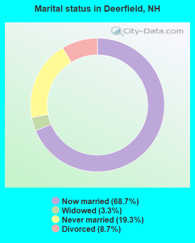
- Never married: 19.3%
- Now married: 68.7%
- Separated: 0.0%
- Widowed: 3.3%
- Divorced: 8.7%
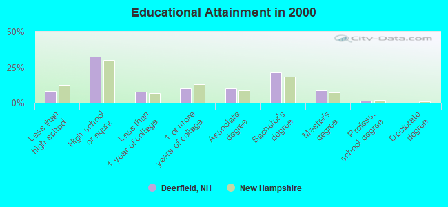
For population 25 years and over in Deerfield:
- High school or higher: 91.7%
- Bachelor's degree or higher: 31.7%
- Graduate or professional degree: 10.4%
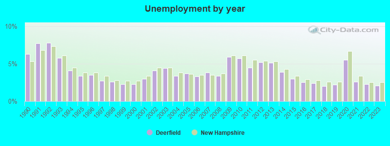
- Unemployed: 2.0%
- Mean travel time to work (commute): 33.9 minutes
| Here: | 10.5 |
| New Hampshire average: | 10.9 |


Graphs represent county-level data. Detailed 2008 Election Results
Religion statistics for Deerfield, NH (based on Rockingham County data)


| Religion | Adherents | Congregations |
|---|---|---|
| Catholic | 84,697 | 24 |
| Mainline Protestant | 19,072 | 78 |
| Evangelical Protestant | 7,456 | 61 |
| Other | 3,490 | 20 |
| Orthodox | 200 | 1 |
| None | 180,308 | - |
Food Environment Statistics:
| This county: | 1.59 / 10,000 pop. |
| New Hampshire: | 2.14 / 10,000 pop. |
| This county: | 0.17 / 10,000 pop. |
| State: | 0.15 / 10,000 pop. |
| Here: | 1.86 / 10,000 pop. |
| State: | 1.78 / 10,000 pop. |
| Rockingham County: | 3.31 / 10,000 pop. |
| State: | 4.02 / 10,000 pop. |
| This county: | 9.56 / 10,000 pop. |
| New Hampshire: | 9.70 / 10,000 pop. |
| Rockingham County: | 7.6% |
| New Hampshire: | 7.6% |
| Rockingham County: | 23.3% |
| State: | 24.4% |
| This county: | 16.8% |
| New Hampshire: | 15.9% |
7.69% of this county's 2021 resident taxpayers lived in other counties in 2020 ($114,534 average adjusted gross income)
| Here: | 7.69% |
| New Hampshire average: | 7.66% |
0.01% of residents moved from foreign countries ($203 average AGI)
Rockingham County: 0.01% New Hampshire average: 0.01%
Top counties from which taxpayers relocated into this county between 2020 and 2021:
| from Essex County, MA | |
| from Hillsborough County, NH | |
| from Middlesex County, MA |
6.82% of this county's 2020 resident taxpayers moved to other counties in 2021 ($88,778 average adjusted gross income)
| Here: | 6.82% |
| New Hampshire average: | 6.80% |
0.01% of residents moved to foreign countries ($126 average AGI)
Rockingham County: 0.01% New Hampshire average: 0.01%
Top counties to which taxpayers relocated from this county between 2020 and 2021:
| to Hillsborough County, NH | |
| to Strafford County, NH | |
| to Essex County, MA |
Strongest AM radio stations in Deerfield:
- WGIR (610 AM; 5 kW; MANCHESTER, NH; Owner: CAPSTAR TX LIMITED PARTNERSHIP)
- WRKO (680 AM; 50 kW; BOSTON, MA; Owner: ENTERCOM BOSTON LICENSE, LLC)
- WGIN (930 AM; 10 kW; ROCHESTER, NH; Owner: CAPSTAR TX LIMITED PARTNERSHIP)
- WDER (1320 AM; 10 kW; DERRY, NH; Owner: BLOUNT COMMUNICATIONS, INC. OF NH)
- WKBR (1250 AM; 5 kW; MANCHESTER, NH; Owner: DEVON BROADCASTING COMPANY, INC.)
- WEEI (850 AM; 50 kW; BOSTON, MA; Owner: ENTERCOM BOSTON LICENSE, LLC)
- WWZN (1510 AM; 50 kW; BOSTON, MA; Owner: ROSE CITY RADIO CORPORATION)
- WBZ (1030 AM; 50 kW; BOSTON, MA; Owner: INFINITY BROADCASTING OPERATIONS, INC.)
- WKOX (1200 AM; 50 kW; FRAMINGHAM, MA; Owner: CAPSTAR TX LIMITED PARTNERSHIP)
- WCRN (830 AM; 50 kW; WORCESTER, MA; Owner: CARTER BROADCASTING CORPORATION)
- WBIX (1060 AM; 40 kW; NATICK, MA; Owner: LANGER BROADCASTING CORPORATION)
- WTSN (1270 AM; 5 kW; DOVER, NH; Owner: GARRISON CITY BROADCASTING, INC.)
- WFEA (1370 AM; 5 kW; MANCHESTER, NH; Owner: SAGA COMMUNICATIONS OF NEW ENGLAND, LLC)
Strongest FM radio stations in Deerfield:
- W282AF (104.3 FM; CONCORD, NH; Owner: CONCORD BIBLE FELLOWSHIP)
- WGIR-FM (101.1 FM; MANCHESTER, NH; Owner: CAPSTAR TX LIMITED PARTNERSHIP)
- WQLL (96.5 FM; BEDFORD, NH; Owner: SAGA COMMUNICATIONS OF NEW ENGLAND, LLC)
- WLMW (90.7 FM; MANCHESTER, NH; Owner: KNOWLEDGE FOR LIFE)
- WZID (95.7 FM; MANCHESTER, NH; Owner: SAGA COMMUNICATIONS OF NEW ENGLAND, LLC)
- WMEX (106.5 FM; FARMINGTON, NH; Owner: WIMMEX, LLC)
- WNHI (93.3 FM; BELMONT, NH; Owner: CONCORD BROADCASTING, L.L.C.)
- WSCY (106.9 FM; MOULTONBOROUGH, NH; Owner: NORTHEAST COMMUNICATIONS CORPORATION)
- WOKQ (97.5 FM; DOVER, NH; Owner: CITADEL BROADCASTING COMPANY)
- WJYY (105.5 FM; CONCORD, NH; Owner: CONCORD BROADCASTING, L.L.C.)
- WLKZ (104.9 FM; WOLFEBORO, NH; Owner: TELE-MEDIA COMPANY OF NEW HAMPSHIRE, L.L.C.)
- WPKQ (103.7 FM; NORTH CONWAY, NH; Owner: CITADEL BROADCASTING COMPANY)
- WHOM (94.9 FM; MT. WASHINGTON, NH; Owner: CITADEL BROADCASTING COMPANY)
- WFEX (92.1 FM; PETERBOROUGH, NH; Owner: FNX BROADCASTING OF NEW HAMPSHIRE LLC)
- WHDQ (106.1 FM; CLAREMONT, NH; Owner: GREAT NORTHERN RADIO, L.L.C.)
- WXRV (92.5 FM; HAVERHILL, MA; Owner: BEANPOT BROADCASTING CORP.)
- WVFM (105.7 FM; CAMPTON, NH; Owner: DEVON BROADCASTING COMPANY, INC.)
- WMEA (90.1 FM; PORTLAND, ME; Owner: MAINE PUBLIC BROADCASTING CORPORATION)
- WVNH (91.1 FM; CONCORD, NH; Owner: NEW HAMPSHIRE GOSPEL RADIO, INC.)
- WEVO (89.1 FM; CONCORD, NH; Owner: NEW HAMPSHIRE PUBLIC RADIO)
TV broadcast stations around Deerfield:
- WENH-TV (Channel 11; DURHAM, NH; Owner: UNIVERSITY OF NEW HAMPSHIRE)
- WPXG (Channel 21; CONCORD, NH; Owner: PAXSON BOSTON-68 LICENSE, INC.)
- WMEA-TV (Channel 26; BIDDEFORD, ME; Owner: MAINE PUBLIC BROADCASTING CORP.)
- WHDN-LP (Channel 26; BOSTON, MA; Owner: GUENTER MARKSTEINER)
- WFXZ-CA (Channel 24; BOSTON, MA; Owner: BOSTON BROADCASTING CORP.)
- WMTW-TV (Channel 8; POLAND SPRING, ME; Owner: WMTW BROADCAST GROUP, LLC)
- WNDS (Channel 50; DERRY, NH; Owner: CTV OF DERRY, INC)
- National Bridge Inventory (NBI) Statistics
- 5Number of bridges
- 20ft / 5.9mTotal length
- $15,710,000Total costs
- 16,108Total average daily traffic
- 642Total average daily truck traffic
- 23,838Total future (year 2042) average daily traffic
FCC Registered Antenna Towers:
5- Paul Hunter, Atop Saddleback Mountain (Lat: 43.175833 Lon: -71.207500), Type: 140.8, Overall height: 118.9 m, Registrant: Schwartz, Woods & Miller, Miller@swmlaw.Com, , Washi-ngton, Phone: (202) 833-1700
- Paul Hunter, Atop Saddleback Mountain (Lat: 43.175833 Lon: -71.207500), Type: 140.8, Overall height: 118.9 m, Registrant: Schwartz, Woods & Miller, Miller@swmlaw.Com, , Washi-ngton, Phone: (202) 833-1700
- Peter A Frid, Atop Saddleback Mountain (Lat: 43.175833 Lon: -71.207500), Type: 140.8, Structure height: 33015 m, Overall height: 118.9 m, Registrant: Schwartz, Woods & Miller, Miller@swmlaw.Com, Suite 900a, Washi-ngton, Phone: (202) 833-1700
- Brad Deutsch, Atop Saddleback Mountain (Lat: 43.175833 Lon: -71.207500), Type: 140.8, Structure height: 33015 m, Overall height: 118.9 m, Registrant: Foster Garvey P.C., Brad.Deutsch@foster.Com, Suite 200, Washi-ngton, Phone: (202) 298-1793
- Atop Saddleback Mountain (Lat: 43.175833 Lon: -71.207500), Type: 140.8, Overall height: 118.9 m, Registrant: University Of New Hampshire, Bill@nhptvll.Unh.Edu, , 1100 Durha-m, Phone: (603) 868-4367
FCC Registered Private Land Mobile Towers:
4 (See the full list of FCC Registered Private Land Mobile Towers in Deerfield, NH)FCC Registered Broadcast Land Mobile Towers:
12 (See the full list of FCC Registered Broadcast Land Mobile Towers)FCC Registered Microwave Towers:
23 (See the full list of FCC Registered Microwave Towers in this town)FCC Registered Paging Towers:
2 (See the full list of FCC Registered Paging Towers)FCC Registered Amateur Radio Licenses:
70 (See the full list of FCC Registered Amateur Radio Licenses in Deerfield)FAA Registered Aircraft:
7- Aircraft: NAVION NAVION A (Category: Land, Seats: 4, Weight: Up to 12,499 Pounds, Speed: 120 mph), Engine: CONT MOTOR E185 SERIES (205 HP) (Reciprocating)
N-Number: 1069P, N1069P, N-1069P, Serial Number: NAV-4-1775, Year manufactured: 1948, Airworthiness Date: 04/03/1961, Certificate Issue Date: 01/02/2013
Registrant (Individual): Sofia V Byrne, 1 Scott Ln, Deerfield, NH 03037
Deregistered: Cancel Date: 05/02/2001 - Aircraft: BEECH B95A (Category: Land, Engines: 2, Seats: 6, Weight: Up to 12,499 Pounds, Speed: 150 mph), Engine: LYCOMING I0360 SER (180 HP) (Reciprocating)
N-Number: 1373Z, N1373Z, N-1373Z, Serial Number: TD-479, Year manufactured: 1961, Airworthiness Date: 08/02/1961, Certificate Issue Date: 04/03/2017
Registrant (Individual): Edward D Jr Hoitt, 13 Meeting House Hill Rd, Deerfield, NH 03037 - Aircraft: HANCOCK JAMES W TANDEM AIR BIKE (Category: Land, Seats: 2, Weight: Up to 12,499 Pounds), Engine: AMA/EXPR UNKNOWN ENG (Reciprocating)
N-Number: 2426A, N2426A, N-2426A, Serial Number: AB 270, Airworthiness Date: 08/22/2001, Certificate Issue Date: 08/20/2018
Registrant (Individual): Richard A Kruse, 70 Griffin Rd, Deerfield, NH 03037
Deregistered: Cancel Date: 10/25/2017 - Aircraft: ICON AIRCRAFT INC A5 (Category: Amphibian, Seats: 2, Weight: Up to 12,499 Pounds), Engine: ROTAX 912 IS (100 HP) (4 Cycle)
N-Number: 293TH, N293TH, N-293TH, Serial Number: 00104, Year manufactured: 2019, Airworthiness Date: 07/05/2019, Certificate Issue Date: 08/30/2019
Registrant (Individual): Timothy Hahn, 2 Ski Doo Ln, Deerfield, NH 03037 - Aircraft: NORTH AMERICAN NAVION A (Category: Land, Seats: 5, Weight: Up to 12,499 Pounds, Speed: 126 mph), Engine: CONT MOTOR E185 SERIES (205 HP) (Reciprocating)
N-Number: 4037K, N4037K, N-4037K, Serial Number: NAV-4-1037, Year manufactured: 1947, Airworthiness Date: 01/20/1956, Certificate Issue Date: 08/19/1987
Registrant (Individual): Sofia V Byrne, 1 Scott Ln, Deerfield, NH 03037 - Aircraft: PIPER PA-32-301T (Category: Land, Seats: 7, Weight: Up to 12,499 Pounds), Engine: LYCOMING TI0-540 SER (310 HP) (Reciprocating)
N-Number: 8427C, N8427C, N-8427C, Serial Number: 32-8124030, Year manufactured: 1981, Airworthiness Date: 03/19/1982, Certificate Issue Date: 03/31/2020
Registrant (Individual): David E Drapeau, 202 Middle Rd, Deerfield, NH 03037 - Aircraft: ICON AIRCRAFT INC A5 (Category: Amphibian, Seats: 2, Weight: Up to 12,499 Pounds), Engine: ROTAX 912 IS (100 HP) (4 Cycle)
N-Number: 713BA, N713BA, N-713BA, Serial Number: 00104, Year manufactured: 2019, Airworthiness Date: 07/05/2019, Certificate Issue Date: 08/30/2019
Registrant (Individual): Timothy Hahn, 2 Ski Doo Ln, Deerfield, NH 03037
2004 - 2018 National Fire Incident Reporting System (NFIRS) incidents
- Fire incident types reported to NFIRS in Deerfield, NH
- 15970.7%Structure Fires
- 4620.4%Outside Fires
- 188.0%Mobile Property/Vehicle Fires
- 20.9%Other
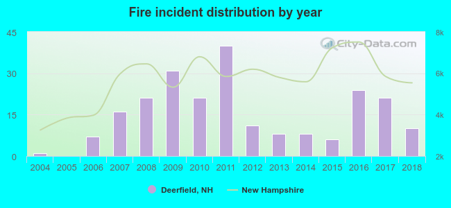 According to the data from the years 2004 - 2018 the average number of fires per year is 15. The highest number of fire incidents - 40 took place in 2011, and the least - 0 in 2005. The data has a rising trend.
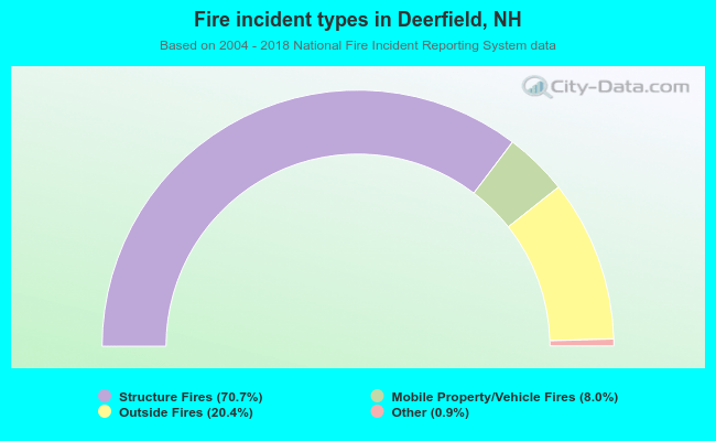 When looking into fire subcategories, the most reports belonged to: Structure Fires (70.7%), and Outside Fires (20.4%).
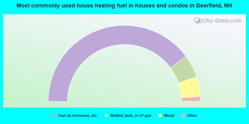
- 79.7%Fuel oil, kerosene, etc.
- 9.8%Bottled, tank, or LP gas
- 8.5%Wood
- 0.5%Utility gas
- 0.5%Coal or coke
- 0.5%Electricity
- 0.5%Other fuel
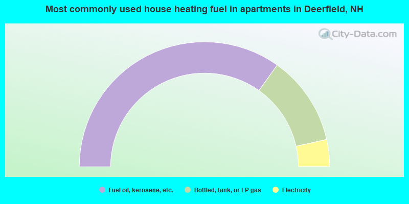
- 69.8%Fuel oil, kerosene, etc.
- 23.3%Bottled, tank, or LP gas
- 7.0%Electricity
Deerfield compared to New Hampshire state average:
- Unemployed percentage significantly below state average.
- Black race population percentage significantly below state average.
- Hispanic race population percentage significantly below state average.
- Foreign-born population percentage significantly below state average.
- Renting percentage significantly below state average.
- Length of stay since moving in significantly above state average.
- Number of rooms per house significantly below state average.
- House age significantly below state average.

|
|
Total of 112 patent applications in 2008-2024.