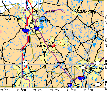
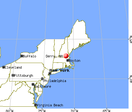
Derry, New Hampshire
Submit your own pictures of this place and show them to the world
- OSM Map
- General Map
- Google Map
- MSN Map
Population change since 2000: -2.9%
| Males: 10,053 | |
| Females: 11,962 |
| Median resident age: | 39.2 years |
| New Hampshire median age: | 43.3 years |
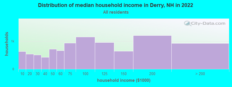
| Derry: | $81,635 |
| NH: | $89,992 |
Estimated per capita income in 2022: $43,753 (it was $21,938 in 2000)
Derry CDP income, earnings, and wages data
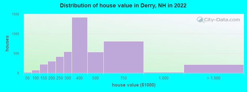
Estimated median house or condo value in 2022: $374,323 (it was $121,500 in 2000)
| Derry: | $374,323 |
| NH: | $384,700 |
Mean prices in 2022: all housing units: $345,581; detached houses: $383,612; townhouses or other attached units: $314,112; in 2-unit structures: $287,125; in 3-to-4-unit structures: $310,617; in 5-or-more-unit structures: $157,498; mobile homes: $127,824
Median gross rent in 2022: $1,430.
(9.5% for White Non-Hispanic residents, 16.7% for Black residents, 19.0% for Hispanic or Latino residents, 31.2% for other race residents, 6.2% for two or more races residents)
Detailed information about poverty and poor residents in Derry, NH


Compare current foreclosures near Derry, NH:
| Photo | Address | Area | Beds / Baths | Price | Details |
|---|---|---|---|---|---|

|
#1
Redfield Cir
Derry, NH 03038
|
2,124 sq. feet
|
3 baths 4 beds |
show details | |

|
#2
Gayle Dr
Derry, NH 03038
|
1,246 sq. feet
|
1 baths 3 beds |
show details | |

|
#3
Brook St
Derry, NH 03038
|
1,666 sq. feet
|
1 baths 4 beds |
show details | |

|
#4
Tsienneto Rd Unit 39
Derry, NH 03038
|
1,936 sq. feet
|
1 baths 2 beds |
show details | |

|
#5
Brook St
Derry, NH 03038
|
1,666 sq. feet
|
1 baths 4 beds |
show details | |

|
#6
1/2 Floyd Rd
Derry, NH 03038
|
2,312 sq. feet
|
2 baths 4 beds |
show details | |

|
#7
Sanborn Rd
Derry, NH 03038
|
1,082 sq. feet
|
2 baths 2 beds |
show details | |

|
#8
Lawrence St
Derry, NH 03038
|
2,124 sq. feet
|
2 baths 3 beds |
show details | |

|
#9
Hoodkroft Dr # B
Derry, NH 03038
|
3,367 sq. feet
|
3 baths 4 beds |
show details | |

|
#10
Beaver Lake Ave
Derry, NH 03038
|
2,190 sq. feet
|
2 baths 3 beds |
show details |
| Photo | Address | Area | Beds / Baths | Price | Details |
|---|---|---|---|---|---|

|
#11
Brook St
Derry, NH 03038
|
1,476 sq. feet
|
1 baths 4 beds |
show details | |

|
#12
Fairview Ave
Derry, NH 03038
|
1,510 sq. feet
|
1 baths 3 beds |
show details | |

|
#13
Scenic Dr
Derry, NH 03038
|
1,692 sq. feet
|
1 baths 2 beds |
show details | |

|
#14
Walnut Hill Rd
Derry, NH 03038
|
2,042 sq. feet
|
2 baths 3 beds |
show details | |

|
#15
Bypass 28
Derry, NH 03038
|
- sq. feet
|
- baths - beds |
show details | |

|
#16
Manchester Rd, Ste 11a Pmb 199
Derry, NH 03038
|
- sq. feet
|
- baths - beds |
show details | |

|
#17
Linlew Dr Apt 9
Derry, NH 03038
|
- sq. feet
|
- baths - beds |
show details | |

|
#18
Circle Dr
Derry, NH 03038
|
- sq. feet
|
- baths - beds |
show details | |

|
#19
Brady Ave
Derry, NH 03038
|
- sq. feet
|
- baths - beds |
show details | |

|
#20
Louise Way
Derry, NH 03038
|
- sq. feet
|
- baths - beds |
show details |
| Photo | Address | Area | Beds / Baths | Price | Details |
|---|---|---|---|---|---|

|
#21
Fairway Dr Apt 2116
Derry, NH 03038
|
- sq. feet
|
- baths - beds |
show details | |

|
#22
Kendall Pond Rd
Derry, NH 03038
|
- sq. feet
|
- baths - beds |
show details | |

|
#23
Fairway Dr Apt 248
Derry, NH 03038
|
- sq. feet
|
- baths - beds |
show details | |

|
#24
Fairway Dr Apt 2625
Derry, NH 03038
|
- sq. feet
|
- baths - beds |
show details | |

|
#25
Alyssa Dr
Derry, NH 03038
|
- sq. feet
|
- baths - beds |
show details | |

|
#26
Franklin St Apt 1
Derry, NH 03038
|
- sq. feet
|
- baths - beds |
show details | |

|
#27
Cedar St # A
Haverhill, MA 01830
|
1,134 sq. feet
|
2 baths 2 beds |
$209,300
|
show details |

|
#28
Shore Dr
Hampstead, NH 03841
|
787 sq. feet
|
1 baths 2 beds |
$529,900
|
show details |

|
#29
Nashua St
Milford, NH 03055
|
2,172 sq. feet
|
2 baths 4 beds |
show details | |

|
#30
Page St
Manchester, NH 03104
|
4,105 sq. feet
|
3 baths 5 beds |
show details |
| Photo | Address | Area | Beds / Baths | Price | Details |
|---|---|---|---|---|---|

|
#31
Roberts Rd
Litchfield, NH 03052
|
1,426 sq. feet
|
1 baths 3 beds |
show details | |

|
#32
Hemlock Cir
Sandown, NH 03873
|
1,912 sq. feet
|
2 baths 4 beds |
show details | |

|
#33
Beede Hill Rd
Fremont, NH 03044
|
1,135 sq. feet
|
1 baths 3 beds |
show details | |

|
#34
Oak Ridge Rd
Plaistow, NH 03865
|
3,089 sq. feet
|
3 baths 5 beds |
show details | |

|
#35
Amherst St
Amherst, NH 03031
|
- sq. feet
|
4 baths 3 beds |
show details | |

|
#36
Blucher St
Manchester, NH 03102
|
2,448 sq. feet
|
2 baths 3 beds |
show details | |

|
#37
Granite St
Manchester, NH 03102
|
1,905 sq. feet
|
2 baths 4 beds |
show details | |

|
#38
Fieldstone Dr
Amherst, NH 03031
|
2,280 sq. feet
|
3 baths 3 beds |
show details | |

|
#39
S Broadway
Lawrence, MA 01843
|
5,706 sq. feet
|
2 baths 6 beds |
show details | |

|
#40
Grace Dr
Nashua, NH 03062
|
1,484 sq. feet
|
1 baths 3 beds |
show details |
| Photo | Address | Area | Beds / Baths | Price | Details |
|---|---|---|---|---|---|

|
#41
Schaefer Cir
Hudson, NH 03051
|
4,358 sq. feet
|
3 baths 5 beds |
show details | |

|
#42
Florence St
Dracut, MA 01826
|
1,523 sq. feet
|
2 baths 3 beds |
show details | |

|
#43
Aiken Ave Apt 15
Lowell, MA 01850
|
1,100 sq. feet
|
1 baths 2 beds |
show details | |

|
#44
Landsdown Dr
Nashua, NH 03062
|
1,860 sq. feet
|
2 baths 3 beds |
show details | |

|
#45
Thornton St
Lawrence, MA 01841
|
912 sq. feet
|
1 baths 2 beds |
show details | |

|
#46
Maclarnon Rd
Salem, NH 03079
|
1,578 sq. feet
|
2 baths 3 beds |
show details | |

|
#47
Frances Street Aka 57 Francis Street
Haverhill, MA 01830
|
1,280 sq. feet
|
2 baths 3 beds |
show details | |

|
#48
S Mammoth Rd
Manchester, NH 03109
|
1,555 sq. feet
|
2 baths 4 beds |
show details | |

|
#49
Grove St
Nashua, NH 03064
|
1,344 sq. feet
|
1 baths 3 beds |
show details | |

|
Check over 1 million property listings on Foreclosure.com!
|
browse all offers | |||


- 20,55488.1%White alone
- 1,6787.2%Hispanic
- 5672.4%Asian alone
- 5252.2%Two or more races
- 460.2%Other race alone
- 50.02%Black alone
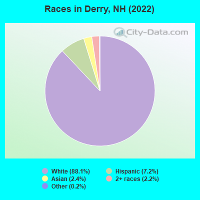
Races in Derry detailed stats: ancestries, foreign born residents, place of birth
According to our research of New Hampshire and other state lists, there were 33 registered sex offenders living in Derry, New Hampshire as of April 19, 2024.
The ratio of all residents to sex offenders in Derry is 682 to 1.
The ratio of registered sex offenders to all residents in this city is lower than the state average.
Type |
2009 |
2010 |
2011 |
2012 |
2013 |
2014 |
2015 |
2016 |
2017 |
2018 |
2019 |
2020 |
2021 |
2022 |
|---|---|---|---|---|---|---|---|---|---|---|---|---|---|---|
| Murders (per 100,000) | 1 (2.9) | 0 (0.0) | 0 (0.0) | 0 (0.0) | 0 (0.0) | 0 (0.0) | 0 (0.0) | 1 (3.0) | 0 (0.0) | 1 (3.0) | 1 (3.0) | 0 (0.0) | 1 (3.0) | 0 (0.0) |
| Rapes (per 100,000) | 6 (17.5) | 5 (15.1) | 10 (30.2) | 8 (24.0) | 22 (66.1) | 14 (42.0) | 14 (41.9) | 12 (36.1) | 8 (24.0) | 9 (26.7) | 18 (53.5) | 16 (47.7) | 28 (82.6) | 13 (37.9) |
| Robberies (per 100,000) | 11 (32.2) | 18 (54.4) | 11 (33.2) | 5 (15.0) | 5 (15.0) | 8 (24.0) | 8 (24.0) | 4 (12.0) | 5 (15.0) | 12 (35.6) | 3 (8.9) | 9 (26.8) | 1 (3.0) | 3 (8.7) |
| Assaults (per 100,000) | 42 (122.8) | 67 (202.4) | 62 (187.0) | 47 (141.2) | 29 (87.1) | 32 (96.0) | 27 (80.9) | 22 (66.2) | 30 (89.9) | 24 (71.2) | 13 (38.6) | 19 (56.6) | 11 (32.5) | 25 (72.9) |
| Burglaries (per 100,000) | 140 (409.5) | 194 (585.9) | 203 (612.3) | 184 (552.8) | 135 (405.5) | 102 (306.0) | 104 (311.5) | 54 (162.4) | 40 (119.8) | 37 (109.7) | 22 (65.3) | 23 (68.5) | 19 (56.1) | 20 (58.3) |
| Thefts (per 100,000) | 554 (1,620) | 594 (1,794) | 627 (1,891) | 570 (1,713) | 525 (1,577) | 498 (1,494) | 453 (1,357) | 412 (1,239) | 307 (919.7) | 253 (750.2) | 246 (730.6) | 242 (721.2) | 219 (646.2) | 243 (708.7) |
| Auto thefts (per 100,000) | 49 (143.3) | 39 (117.8) | 38 (114.6) | 37 (111.2) | 27 (81.1) | 17 (51.0) | 34 (101.8) | 33 (99.3) | 21 (62.9) | 27 (80.1) | 10 (29.7) | 27 (80.5) | 19 (56.1) | 20 (58.3) |
| Arson (per 100,000) | 21 (61.4) | 24 (72.5) | 26 (78.4) | 18 (54.1) | 13 (39.0) | 15 (45.0) | 7 (21.0) | 5 (15.0) | 6 (18.0) | 4 (11.9) | 5 (14.8) | 9 (26.8) | 5 (14.8) | 5 (14.6) |
| City-Data.com crime index | 159.1 | 191.1 | 199.2 | 168.1 | 172.7 | 145.3 | 141.1 | 120.6 | 91.8 | 96.3 | 95.3 | 97.6 | 113.6 | 84.6 |
The City-Data.com crime index weighs serious crimes and violent crimes more heavily. Higher means more crime, U.S. average is 246.1. It adjusts for the number of visitors and daily workers commuting into cities.
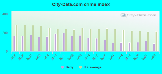
Crime rate in Derry detailed stats: murders, rapes, robberies, assaults, burglaries, thefts, arson
Full-time law enforcement employees in 2021, including police officers: 67 (54 officers - 46 male; 8 female).
| Officers per 1,000 residents here: | 1.59 |
| New Hampshire average: | 2.14 |
 Recent articles from our blog. Our writers, many of them Ph.D. graduates or candidates, create easy-to-read articles on a wide variety of topics.


Latest news from Derry, NH collected exclusively by city-data.com from local newspapers, TV, and radio stations
Ancestries: Irish (19.0%), Italian (9.7%), French Canadian (9.4%), French (9.2%), American (8.3%), English (5.6%).
Current Local Time: EST time zone
Incorporated in 1827
Elevation: 290 feet
Land area: 15.4 square miles.
Population density: 1,427 people per square mile (low).
1,182 residents are foreign born (2.2% Asia, 1.6% Europe, 0.9% Latin America).
| This place: | 5.1% |
| New Hampshire: | 6.0% |
Median real estate property taxes paid for housing units with mortgages in 2022: $6,450 (1.7%)
Median real estate property taxes paid for housing units with no mortgage in 2022: $7,033 (1.9%)
Nearest city with pop. 50,000+: Manchester, NH  (10.1 miles , pop. 107,006).
Nearest city with pop. 200,000+: Boston, MA (40.5 miles , pop. 589,141).
Nearest city with pop. 1,000,000+: Bronx, NY (193.1 miles , pop. 1,332,650).
Nearest cities:
), ), Latitude: 42.88 N, Longitude: 71.31 W
Daytime population change due to commuting: -2,751 (-11.8%)
Workers who live and work in this place: 3,701 (30.3%)
Area code: 603
Derry, New Hampshire accommodation & food services, waste management - Economy and Business Data
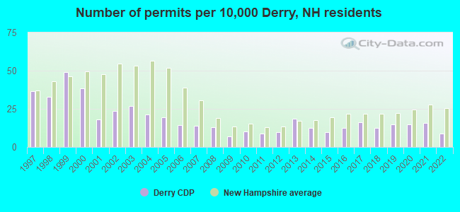
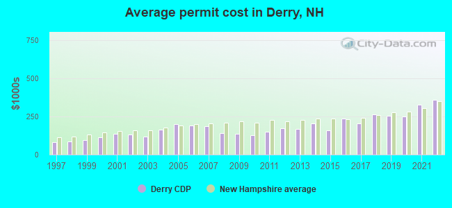
Single-family new house construction building permits:
- 2022: 20 buildings, average cost: $357,100
- 2021: 36 buildings, average cost: $327,800
- 2020: 34 buildings, average cost: $249,900
- 2019: 34 buildings, average cost: $254,200
- 2018: 28 buildings, average cost: $262,300
- 2017: 37 buildings, average cost: $204,300
- 2016: 28 buildings, average cost: $236,500
- 2015: 22 buildings, average cost: $157,100
- 2014: 28 buildings, average cost: $203,200
- 2013: 42 buildings, average cost: $168,600
- 2012: 22 buildings, average cost: $171,100
- 2011: 20 buildings, average cost: $150,800
- 2010: 23 buildings, average cost: $124,800
- 2009: 16 buildings, average cost: $134,900
- 2008: 29 buildings, average cost: $138,600
- 2007: 32 buildings, average cost: $187,800
- 2006: 33 buildings, average cost: $192,400
- 2005: 44 buildings, average cost: $198,700
- 2004: 48 buildings, average cost: $163,100
- 2003: 61 buildings, average cost: $117,700
- 2002: 54 buildings, average cost: $131,100
- 2001: 41 buildings, average cost: $136,300
- 2000: 87 buildings, average cost: $113,000
- 1999: 111 buildings, average cost: $94,300
- 1998: 74 buildings, average cost: $86,800
- 1997: 83 buildings, average cost: $79,900
| Here: | 2.6% |
| New Hampshire: | 2.5% |
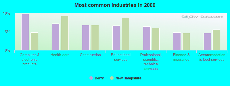
- Computer & electronic products (9.8%)
- Health care (7.2%)
- Construction (6.8%)
- Educational services (6.6%)
- Professional, scientific, technical services (6.5%)
- Finance & insurance (4.8%)
- Accommodation & food services (4.6%)
- Computer & electronic products (11.1%)
- Construction (11.1%)
- Professional, scientific, technical services (6.7%)
- Administrative & support & waste management services (4.2%)
- Accommodation & food services (3.5%)
- Finance & insurance (3.4%)
- Public administration (3.3%)
- Health care (12.9%)
- Educational services (10.7%)
- Computer & electronic products (8.2%)
- Finance & insurance (6.3%)
- Professional, scientific, technical services (6.2%)
- Accommodation & food services (6.0%)
- Department & other general merchandise stores (4.3%)
- Computer specialists (4.4%)
- Other sales and related occupations, including supervisors (4.3%)
- Material recording, scheduling, dispatching, and distributing workers (4.1%)
- Other management occupations, except farmers and farm managers (4.0%)
- Other production occupations, including supervisors (3.8%)
- Other office and administrative support workers, including supervisors (3.3%)
- Electrical equipment mechanics and other installation, maintenance, and repair workers, including supervisors (2.7%)
- Computer specialists (6.7%)
- Material recording, scheduling, dispatching, and distributing workers (5.6%)
- Electrical equipment mechanics and other installation, maintenance, and repair workers, including supervisors (4.8%)
- Other management occupations, except farmers and farm managers (4.4%)
- Engineers (4.3%)
- Other sales and related occupations, including supervisors (4.3%)
- Other production occupations, including supervisors (4.2%)
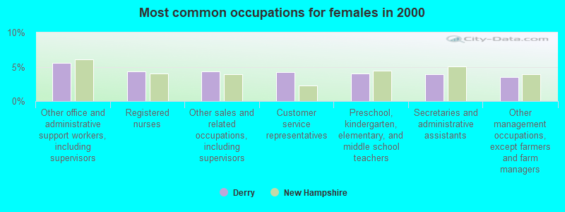
- Other office and administrative support workers, including supervisors (5.6%)
- Registered nurses (4.3%)
- Other sales and related occupations, including supervisors (4.3%)
- Customer service representatives (4.2%)
- Preschool, kindergarten, elementary, and middle school teachers (4.0%)
- Secretaries and administrative assistants (3.9%)
- Other management occupations, except farmers and farm managers (3.5%)
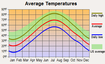
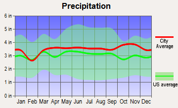
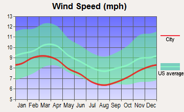
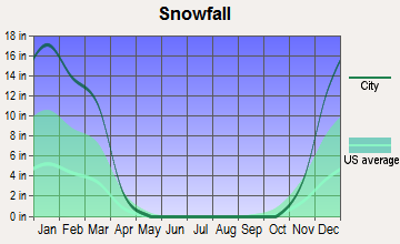
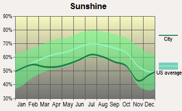
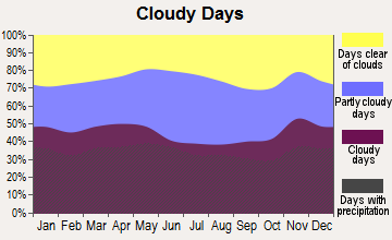
Average climate in Derry, New Hampshire
Based on data reported by over 4,000 weather stations

|
|


(lower is better)
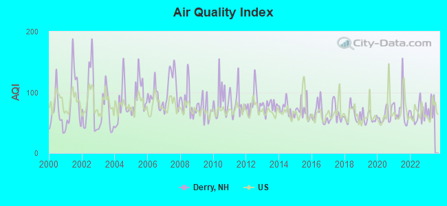
Air Quality Index (AQI) level in 2022 was 64.9. This is about average.
| City: | 64.9 |
| U.S.: | 72.6 |
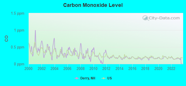
Carbon Monoxide (CO) [ppm] level in 2022 was 0.157. This is significantly better than average. Closest monitor was 3.9 miles away from the city center.
| City: | 0.157 |
| U.S.: | 0.251 |
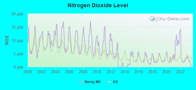
Nitrogen Dioxide (NO2) [ppb] level in 2022 was 3.51. This is significantly better than average. Closest monitor was 3.9 miles away from the city center.
| City: | 3.51 |
| U.S.: | 5.11 |
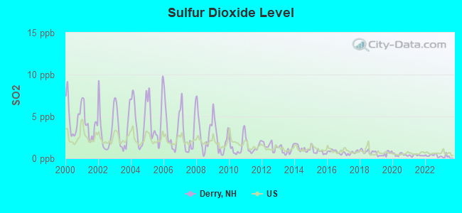
Sulfur Dioxide (SO2) [ppb] level in 2022 was 0.338. This is significantly better than average. Closest monitor was 3.9 miles away from the city center.
| City: | 0.338 |
| U.S.: | 1.515 |
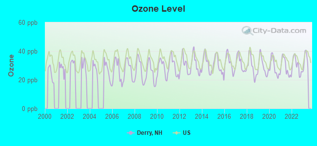
Ozone [ppb] level in 2022 was 29.8. This is about average. Closest monitor was 3.9 miles away from the city center.
| City: | 29.8 |
| U.S.: | 33.3 |
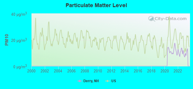
Particulate Matter (PM10) [µg/m3] level in 2022 was 10.6. This is significantly better than average. Closest monitor was 3.9 miles away from the city center.
| City: | 10.6 |
| U.S.: | 19.2 |
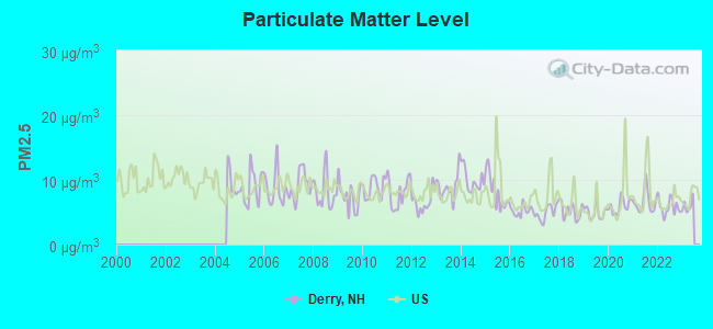
Particulate Matter (PM2.5) [µg/m3] level in 2022 was 5.82. This is better than average. Closest monitor was 3.9 miles away from the city center.
| City: | 5.82 |
| U.S.: | 8.11 |
Tornado activity:
Derry-area historical tornado activity is slightly above New Hampshire state average. It is 38% smaller than the overall U.S. average.
On 6/9/1953, a category F3 (max. wind speeds 158-206 mph) tornado 18.1 miles away from the Derry place center injured 5 people and caused between $5000 and $50,000 in damages.
On 9/29/1974, a category F3 tornado 19.1 miles away from the place center injured one person and caused between $50,000 and $500,000 in damages.
Earthquake activity:
Derry-area historical earthquake activity is significantly above New Hampshire state average. It is 72% smaller than the overall U.S. average.On 4/20/2002 at 10:50:47, a magnitude 5.3 (5.3 ML, Depth: 3.0 mi, Class: Moderate, Intensity: VI - VII) earthquake occurred 164.2 miles away from Derry center
On 10/7/1983 at 10:18:46, a magnitude 5.3 (5.1 MB, 5.3 LG, 5.1 ML) earthquake occurred 169.4 miles away from the city center
On 1/19/1982 at 00:14:42, a magnitude 4.7 (4.5 MB, 4.7 MD, 4.5 LG, Class: Light, Intensity: IV - V) earthquake occurred 45.1 miles away from the city center
On 4/20/2002 at 10:50:47, a magnitude 5.2 (5.2 MB, 4.2 MS, 5.2 MW, 5.0 MW) earthquake occurred 163.7 miles away from the city center
On 10/16/2012 at 23:12:25, a magnitude 4.7 (4.7 ML, Depth: 10.0 mi) earthquake occurred 59.3 miles away from the city center
On 8/22/1992 at 12:20:32, a magnitude 4.8 (4.8 MB, 3.8 MS, 4.7 LG, Depth: 6.2 mi) earthquake occurred 266.4 miles away from Derry center
Magnitude types: regional Lg-wave magnitude (LG), body-wave magnitude (MB), duration magnitude (MD), local magnitude (ML), surface-wave magnitude (MS), moment magnitude (MW)
Natural disasters:
The number of natural disasters in Rockingham County (26) is a lot greater than the US average (15).Major Disasters (Presidential) Declared: 17
Emergencies Declared: 9
Causes of natural disasters: Storms: 12, Floods: 9, Winter Storms: 5, Hurricanes: 4, Snowstorms: 4, Snows: 2, Winds: 2, Blizzard: 1, Snowfall: 1, Tornado: 1 (Note: some incidents may be assigned to more than one category).
Hospitals and medical centers in Derry:
- NUTFIELD SURGICENTER (44 BIRCH STREET, SUITE 304)
- PARKLAND MEDICAL CENTER (Proprietary, 1 PARKLAND DRIVE)
- COLUMBIA HOMECARE PARKLAND MEDICAL CTR (44 BIRCH STREET SUITE 104)
- TENDER CARE HOME NURSING SERV (4 BIRCH STREET)
- AURORA SENIOR LIVING OF DERRY, LLC (20 CHESTER ROAD)
- PLEASANT VALLEY NURSING CENTER (8 PEABODY ROAD)
Heliports located in Derry:
See details about Heliports located in Derry, NHColleges/universities with over 2000 students nearest to Derry:
- Mount Washington College (about 11 miles; Manchester, NH; Full-time enrollment: 2,187)
- Saint Anselm College (about 13 miles; Manchester, NH; FT enrollment: 2,059)
- Southern New Hampshire University (about 14 miles; Manchester, NH; FT enrollment: 16,552)
- Northern Essex Community College (about 15 miles; Haverhill, MA; FT enrollment: 4,737)
- University of Massachusetts-Lowell (about 16 miles; Lowell, MA; FT enrollment: 12,341)
- Merrimack College (about 18 miles; North Andover, MA; FT enrollment: 2,734)
- Middlesex Community College (about 25 miles; Bedford, MA; FT enrollment: 6,040)
Public high schools in Derry:
- PINKERTON ACADEMY (Students: 3,358, Location: 5 PINKERTON ST., Grades: 9-12)
- NEXT CHARTER SCHOOL (Location: 1 WEST RUNNING BROOK LANE, Grades: 9-11, Charter school)
- GRANITE STATE ARTS ACADEMY CHARTER SCHOOL (Location: 16 ROUTE 111, Grades: 9-12, Charter school)
Public elementary/middle schools in Derry:
- GILBERT H. HOOD MIDDLE SCHOOL (Students: 886, Location: 5 HOOD RD., Grades: 6-8)
- WEST RUNNING BROOK MIDDLE SCHOOL (Students: 715, Location: 1 W. RUNNING BROOK LN., Grades: 6-8)
- ERNEST P. BARKA ELEMENTARY SCHOOL (Students: 561, Location: 21 EASTGATE RD., Grades: KG-5)
- EAST DERRY MEMORIAL ELEMENTARY SCHOOL (Students: 465, Location: 18 DUBEAU DR., Grades: KG-5)
- DERRY VILLAGE SCHOOL (Students: 415, Location: 28 S. MAIN ST., Grades: KG-5)
- GRINNELL SCHOOL (Students: 384, Location: 6 GRINNELL RD., Grades: KG-5)
- SOUTH RANGE ELEMENTARY SCHOOL (Students: 344, Location: 1 DRURY LN., Grades: KG-5)
Private elementary/middle school in Derry:
- ST THOMAS AQUINAS SCHOOL (Students: 210, Location: 3 MOODY ST, Grades: PK-8)
User-submitted facts and corrections:
- WNDS-TV is now WZMY-TV and is owned by ShootingStar Broadcasting on New England, LLC.
- 97.5 wokq out of durham, nh can be heard from me to ma WOKQ a citidal broadcasting station is very strong
- Floyd School has been closed added by Tom
Points of interest:
Notable locations in Derry: Hoodkroft Country Club (A), Hidden Valley Campground (B), Robert Frost Farm (C), Derry Fire Department Station 4 Hampstead Road Station (D), Derry Fire Department Central Station Headquarters (E), Derry Public Library (F), Derry Town Hall (G), Derry Fire Department Station 2 Island Pond Road Station (H), Parkland Medical Center Library (I), Taylor Library (J), Boys and Girls Club (K), West Side Community Center (L), Greater Derry Chamber of Commerce (M). Display/hide their locations on the map
Shopping Centers: Hood Shopping Plaza Shopping Center (1), Hood Commons Shopping Center (2). Display/hide their locations on the map
Churches in Derry include: Church of the Transfiguration (A), Calvary Bible Church (B), Trinity Assembly of God Church (C), Saint Lukes United Methodist Church (D), Calvary Chapel Merrimack (E), Greater Derry Church of Christ (F), First Church of Christ Scientist (G), First Baptist Church (H), Saint Thomas Aquinas Parish Church (I). Display/hide their locations on the map
Lakes and reservoirs: Horns Pond (A), Lower Shields Pond (B), The Meadow Reservoir (C), Benjamin Adams Pond (D), Beaver Lake (E), Hoods Pond (F). Display/hide their locations on the map
Streams, rivers, and creeks: West Running Brook (A), Leavitt Brook (B), Cunningham Brook (C). Display/hide their locations on the map
Parks in Derry include: East Derry Historic District (1), MacGregor Park (2), Carr Playground (3), Moonscape Playground (4), Alexander-Carr Playground (5), Hood Park (6). Display/hide their locations on the map
Tourist attractions: Children's Metamorphosis (Museums; 6 West Broadway) (1), Mr B'S LAN Party (Amusement & Theme Parks; 35 Manchester Road) (2), A&A Balloon Rides (Recreational Trips & Guides; 78 Warner Hill Rd) (3). Display/hide their approximate locations on the map
Court: Derry District Court - Clerk of Court (10 Manning Street) (1). Display/hide its approximate location on the map
Birthplace of: Alan Shepard - Astronaut, Paul Thompson (ice hockey b. 1988) - Ice hockey player, Aaron Fletcher Stevens - Union Army general, Charles M. Floyd - Politician, Fred Tyler (baseball) - Major League Baseball player, Lefty Tyler - Baseball player, Tricia Dunn-Luoma - Ice hockey player, Pat Ingraham - Montana politician.
Drinking water stations with addresses in Derry and their reported violations in the past:
PROMISES TO KEEP (Population served: 400, Groundwater):Past health violations:CENTENNIAL ESTATES (Population served: 132, Groundwater):Past monitoring violations:
- MCL, Monthly (TCR) - Between JUL-2011 and SEP-2011, Contaminant: Coliform. Follow-up actions: St Public Notif requested (AUG-08-2011), St Violation/Reminder Notice (AUG-08-2011), St Public Notif received (NOV-17-2011), St Compliance achieved (APR-16-2012)
- Failure To Address Deficiency - In FEB-09-2014, Contaminant: GROUNDWATER RULE. Follow-up actions: St Public Notif requested (FEB-28-2014), St Formal NOV issued (FEB-28-2014), St Public Notif received (APR-21-2014), St Compliance achieved (JUN-23-2014)
- 2 routine major monitoring violations
Past health violations:STONE HOUSE CLUB (Serves RI, Population served: 108, Groundwater):Past monitoring violations:
- MCL, Monthly (TCR) - In AUG-2012, Contaminant: Coliform. Follow-up actions: St Public Notif requested (SEP-04-2012), St Violation/Reminder Notice (SEP-04-2012), St Public Notif received (SEP-17-2012), St Compliance achieved (MAR-05-2013)
- Monitoring, Source Water (GWR) - Between AUG-03-2012 and SEP-03-2012, Contaminant: E. COLI. Follow-up actions: St Public Notif requested (SEP-18-2012), St Violation/Reminder Notice (SEP-18-2012), St Compliance achieved (SEP-18-2012), St Public Notif received (JAN-17-2013)
- Monitoring, Repeat Major (TCR) - In JUL-2012, Contaminant: Coliform (TCR). Follow-up actions: St Public Notif requested (SEP-18-2012), St Violation/Reminder Notice (SEP-18-2012), St Compliance achieved (SEP-18-2012), St Public Notif received (JAN-17-2013)
- 4 routine major monitoring violations
- 36 regular monitoring violations
Past monitoring violations:BARKLAND ACRES (Population served: 80, Groundwater):
- Monitoring, Source Water (GWR) - In OCT-01-2013, Contaminant: E. COLI. Follow-up actions: St Violation/Reminder Notice (SEP-12-2013), St Formal NOV issued (SEP-12-2013), St Public Notif requested (SEP-12-2013), St Public Notif received (NOV-05-2013)
- 2 routine major monitoring violations
- 3 minor monitoring violations
Past health violations:ROWES CORNER MARKET (Population served: 50, Groundwater):
- MCL, Average - Between APR-2014 and JUN-2014, Contaminant: Arsenic. Follow-up actions: St Violation/Reminder Notice (JUL-01-2014), St Public Notif requested (JUL-01-2014)
- MCL, Average - Between JAN-2014 and MAR-2014, Contaminant: Arsenic. Follow-up actions: St Public Notif requested (APR-02-2014), St Violation/Reminder Notice (APR-02-2014), St Public Notif received (APR-09-2014)
Past health violations:FROST RESIDENTS (Population served: 49, Groundwater):Past monitoring violations:
- MCL, Monthly (TCR) - Between JUL-2012 and SEP-2012, Contaminant: Coliform. Follow-up actions: St Public Notif requested (AUG-02-2012), St Violation/Reminder Notice (AUG-02-2012), St Public Notif received (AUG-20-2012), St Compliance achieved (JAN-17-2013)
- MCL, Monthly (TCR) - Between APR-2005 and JUN-2005, Contaminant: Coliform. Follow-up actions: St Public Notif requested (JUL-21-2005), St Violation/Reminder Notice (JUL-21-2005), St Public Notif received (NOV-14-2005), St Compliance achieved (APR-06-2006)
- Monitoring, Source Water (GWR) - Between JUN-28-2012 and JUL-28-2012, Contaminant: E. COLI. Follow-up actions: St Public Notif requested (AUG-07-2012), St Violation/Reminder Notice (AUG-07-2012), St Compliance achieved (AUG-07-2012), St Public Notif received (AUG-20-2012)
- Monitoring, Repeat Major (TCR) - Between APR-2012 and JUN-2012, Contaminant: Coliform (TCR). Follow-up actions: St Public Notif requested (AUG-07-2012), St Violation/Reminder Notice (AUG-07-2012), St Compliance achieved (AUG-07-2012), St Public Notif received (AUG-20-2012)
- Monitoring, Repeat Major (TCR) - Between JUL-2009 and SEP-2009, Contaminant: Coliform (TCR). Follow-up actions: St Violation/Reminder Notice (OCT-26-2009), St Public Notif requested (OCT-26-2009), St Compliance achieved (NOV-24-2009), St Public Notif received (MAR-11-2010)
- Monitoring, Repeat Major (TCR) - Between APR-2009 and JUN-2009, Contaminant: Coliform (TCR). Follow-up actions: St Violation/Reminder Notice (JUL-22-2009), St Public Notif requested (JUL-22-2009), St Formal NOV issued (SEP-24-2009), St Compliance achieved (OCT-13-2009), St Public Notif received (MAR-11-2010)
- 8 routine major monitoring violations
Past monitoring violations:ROBERT FROST MOTOR INN (Population served: 40, Groundwater):
- Failure To Address Deficiency - In JAN-10-2014, Contaminant: GROUNDWATER RULE. Follow-up actions: St Public Notif requested (JAN-31-2014), St Formal NOV issued (JAN-31-2014), St Compliance achieved (FEB-07-2014), St Public Notif received (FEB-10-2014)
- One routine major monitoring violation
Past health violations:Past monitoring violations:
- MCL, Monthly (TCR) - Between JUL-2010 and SEP-2010, Contaminant: Coliform. Follow-up actions: St Public Notif requested (JUL-20-2010), St Violation/Reminder Notice (JUL-20-2010), St Public Notif received (JUL-28-2010), St Formal NOV issued (JUL-30-2010), St Compliance achieved (JAN-03-2011)
- MCL, Monthly (TCR) - Between APR-2010 and JUN-2010, Contaminant: Coliform. Follow-up actions: St Public Notif requested (JUN-28-2010), St Violation/Reminder Notice (JUN-28-2010), St Public Notif received (JUL-02-2010), St Formal NOV issued (JUL-30-2010), St Compliance achieved (JAN-03-2011)
- 3 routine major monitoring violations
Drinking water stations with addresses in Derry that have no violations reported:
- DERRY WATER DEPT (Address: 14 MANNING ST , Population served: 15,145, Primary Water Source Type: Purch surface water)
- EPSOM HEALTHCARE CTR (Population served: 226, Primary Water Source Type: Groundwater)
- ST MATTHEWS UNITED METHODIST (Population served: 200, Primary Water Source Type: Groundwater)
- BRANCH RIVER APARTMENTS (Population served: 120, Primary Water Source Type: Groundwater)
- MORNINGSIDE DRIVE (Population served: 80, Primary Water Source Type: Groundwater)
- AUTUMN WOODS (Address: 14 MANNING ST , Population served: 73, Primary Water Source Type: Groundwater)
- SHAKER HEIGHTS PROF PLAZA (Population served: 50, Primary Water Source Type: Groundwater)
| This place: | 2.5 people |
| New Hampshire: | 2.5 people |
| This place: | 64.8% |
| Whole state: | 66.3% |
| This place: | 9.6% |
| Whole state: | 8.3% |
Likely homosexual households (counted as self-reported same-sex unmarried-partner households)
- Lesbian couples: 0.6% of all households
- Gay men: 0.3% of all households
People in group quarters in Derry in 2010:
- 143 people in nursing facilities/skilled-nursing facilities
- 31 people in other noninstitutional facilities
- 7 people in group homes for juveniles (non-correctional)
People in group quarters in Derry in 2000:
- 160 people in nursing homes
- 23 people in other noninstitutional group quarters
- 6 people in other group homes
Banks with branches in Derry (2011 data):
- People's United Bank: Derry Branch at 51 Crystal Avenue, branch established on 2009/01/20; Derry Branch at 38 Birch Street, branch established on 2001/09/12. Info updated 2012/02/16: Bank assets: $27,319.3 mil, Deposits: $20,835.4 mil, headquarters in Bridgeport, CT, positive income, Commercial Lending Specialization, 374 total offices
- Sovereign Bank, National Association: Derry Branch at 20 East Broadway, branch established on 1906/01/01. Info updated 2012/01/31: Bank assets: $78,146.9 mil, Deposits: $48,042.9 mil, headquarters in Wilmington, DE, positive income, Commercial Lending Specialization, 718 total offices, Holding Company: Banco Santander, S.A.
- Enterprise Bank and Trust Company: Derry Nh Branch at 47 Crystal Avenue, branch established on 2010/06/01. Info updated 2006/11/03: Bank assets: $1,488.4 mil, Deposits: $1,333.6 mil, headquarters in Lowell, MA, positive income, Commercial Lending Specialization, 20 total offices, Holding Company: Enterprise Bancorp, Inc.
- RBS Citizens, National Association: Derry Branch at 42 Pinkerton Street, branch established on 2000/04/15. Info updated 2007/09/19: Bank assets: $106,940.6 mil, Deposits: $75,690.2 mil, headquarters in Providence, RI, positive income, 1135 total offices, Holding Company: Uk Financial Investments Limited
- TD Bank, National Association: Manchester Road Branch at 35 Manchester Road, branch established on 2000/06/12. Info updated 2010/10/04: Bank assets: $188,912.6 mil, Deposits: $153,149.8 mil, headquarters in Wilmington, DE, positive income, 1314 total offices, Holding Company: Toronto-Dominion Bank, The
- Bank of America, National Association: Derry-Crystal Ave Branch at 57 Crystal Avenue, branch established on 1997/05/23. Info updated 2009/11/18: Bank assets: $1,451,969.3 mil, Deposits: $1,077,176.8 mil, headquarters in Charlotte, NC, positive income, 5782 total offices, Holding Company: Bank Of America Corporation
For population 15 years and over in Derry:
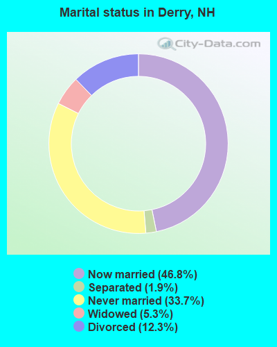
- Never married: 33.7%
- Now married: 46.8%
- Separated: 1.9%
- Widowed: 5.3%
- Divorced: 12.3%
For population 25 years and over in Derry:
- High school or higher: 91.3%
- Bachelor's degree or higher: 31.8%
- Graduate or professional degree: 9.7%
- Unemployed: 4.0%
- Mean travel time to work (commute): 24.4 minutes
| Here: | 9.5 |
| New Hampshire average: | 10.3 |


Graphs represent county-level data. Detailed 2008 Election Results
Neighborhoods in Derry:
(Derry, New Hampshire Neighborhood Map)- Applewood Village (Apple Wood Village) neighborhood
- Bangs Mobile Park (Bangs Housing Corp) neighborhood
- Barkland Acres neighborhood
- Bellebrook (Bellbrook) neighborhood
- Big Island Pond neighborhood
- Bliss Farms (Bliss Farm) neighborhood
- Derryfield Estates neighborhood
- Downtown neighborhood
- Drew Wood (Drew Woods) neighborhood
- Fieldstone Terrace neighborhood
- Garden Meadows neighborhood
- Harvest Estates neighborhood
- Hemlock Springs neighborhood
- Hillside Estates (Hillside) neighborhood
- Lakewood Esates neighborhood
- Lampton Woods neighborhood
- Newells Meadow neighborhood
- Old English Estates neighborhood
- Quail Hill (Quail Hill Estates) neighborhood
- Redfield neighborhood
- Running Brook Farm neighborhood
- Stonegate neighborhood
- Whittemore Estates (Whittemore Estate) neighborhood
Religion statistics for Derry, NH (based on Rockingham County data)


| Religion | Adherents | Congregations |
|---|---|---|
| Catholic | 84,697 | 24 |
| Mainline Protestant | 19,072 | 78 |
| Evangelical Protestant | 7,456 | 61 |
| Other | 3,490 | 20 |
| Orthodox | 200 | 1 |
| None | 180,308 | - |
Food Environment Statistics:
| Rockingham County: | 1.59 / 10,000 pop. |
| State: | 2.14 / 10,000 pop. |
| Here: | 0.17 / 10,000 pop. |
| State: | 0.15 / 10,000 pop. |
| Here: | 1.86 / 10,000 pop. |
| State: | 1.78 / 10,000 pop. |
| This county: | 3.31 / 10,000 pop. |
| New Hampshire: | 4.02 / 10,000 pop. |
| This county: | 9.56 / 10,000 pop. |
| New Hampshire: | 9.70 / 10,000 pop. |
| Rockingham County: | 7.6% |
| State: | 7.6% |
| Rockingham County: | 23.3% |
| State: | 24.4% |
| This county: | 16.8% |
| New Hampshire: | 15.9% |
Health and Nutrition:
| This city: | 49.8% |
| State: | 51.2% |
| Derry: | 48.6% |
| State: | 49.1% |
| Here: | 28.6 |
| State: | 28.5 |
| Derry: | 21.9% |
| State: | 20.9% |
| Here: | 8.8% |
| New Hampshire: | 9.3% |
| Derry: | 6.8 |
| State: | 6.9 |
| Here: | 33.6% |
| State: | 34.3% |
| Here: | 58.7% |
| State: | 58.1% |
| This city: | 80.8% |
| New Hampshire: | 79.1% |
More about Health and Nutrition of Derry, NH Residents
7.69% of this county's 2021 resident taxpayers lived in other counties in 2020 ($114,534 average adjusted gross income)
| Here: | 7.69% |
| New Hampshire average: | 7.66% |
0.01% of residents moved from foreign countries ($203 average AGI)
Rockingham County: 0.01% New Hampshire average: 0.01%
Top counties from which taxpayers relocated into this county between 2020 and 2021:
| from Essex County, MA | |
| from Hillsborough County, NH | |
| from Middlesex County, MA |
6.82% of this county's 2020 resident taxpayers moved to other counties in 2021 ($88,778 average adjusted gross income)
| Here: | 6.82% |
| New Hampshire average: | 6.80% |
0.01% of residents moved to foreign countries ($126 average AGI)
Rockingham County: 0.01% New Hampshire average: 0.01%
Top counties to which taxpayers relocated from this county between 2020 and 2021:
| to Hillsborough County, NH | |
| to Strafford County, NH | |
| to Essex County, MA |
| Businesses in Derry, NH | ||||
| Name | Count | Name | Count | |
|---|---|---|---|---|
| 7-Eleven | 2 | MasterBrand Cabinets | 5 | |
| Applebee's | 1 | McDonald's | 1 | |
| AutoZone | 1 | Payless | 1 | |
| Burger King | 1 | Pizza Hut | 1 | |
| CVS | 1 | RadioShack | 1 | |
| Chevrolet | 1 | Rite Aid | 2 | |
| Circle K | 1 | Shaw's | 1 | |
| Domino's Pizza | 1 | Sprint Nextel | 1 | |
| Dunkin Donuts | 5 | Subway | 1 | |
| Fashion Bug | 1 | T-Mobile | 2 | |
| FedEx | 5 | U-Haul | 2 | |
| GNC | 1 | UPS | 4 | |
| GameStop | 1 | Walgreens | 1 | |
| H&R Block | 1 | Walmart | 1 | |
| KFC | 1 | Wendy's | 1 | |
Strongest AM radio stations in Derry:
- WDER (1320 AM; 10 kW; DERRY, NH; Owner: BLOUNT COMMUNICATIONS, INC. OF NH)
- WRKO (680 AM; 50 kW; BOSTON, MA; Owner: ENTERCOM BOSTON LICENSE, LLC)
- WCEC (1110 AM; daytime; 5 kW; SALEM, NH; Owner: COSTA-EAGLE RADIO VENTURES LTD PARTNERSHIP)
- WFEA (1370 AM; 5 kW; MANCHESTER, NH; Owner: SAGA COMMUNICATIONS OF NEW ENGLAND, LLC)
- WGIR (610 AM; 5 kW; MANCHESTER, NH; Owner: CAPSTAR TX LIMITED PARTNERSHIP)
- WEEI (850 AM; 50 kW; BOSTON, MA; Owner: ENTERCOM BOSTON LICENSE, LLC)
- WWZN (1510 AM; 50 kW; BOSTON, MA; Owner: ROSE CITY RADIO CORPORATION)
- WKOX (1200 AM; 50 kW; FRAMINGHAM, MA; Owner: CAPSTAR TX LIMITED PARTNERSHIP)
- WKBR (1250 AM; 5 kW; MANCHESTER, NH; Owner: DEVON BROADCASTING COMPANY, INC.)
- WBIX (1060 AM; 40 kW; NATICK, MA; Owner: LANGER BROADCASTING CORPORATION)
- WBZ (1030 AM; 50 kW; BOSTON, MA; Owner: INFINITY BROADCASTING OPERATIONS, INC.)
- WCRN (830 AM; 50 kW; WORCESTER, MA; Owner: CARTER BROADCASTING CORPORATION)
- WCAP (980 AM; 5 kW; LOWELL, MA; Owner: NORTHEAST RADIO, INC.)
Strongest FM radio stations in Derry:
- WGIR-FM (101.1 FM; MANCHESTER, NH; Owner: CAPSTAR TX LIMITED PARTNERSHIP)
- WQLL (96.5 FM; BEDFORD, NH; Owner: SAGA COMMUNICATIONS OF NEW ENGLAND, LLC)
- WLMW (90.7 FM; MANCHESTER, NH; Owner: KNOWLEDGE FOR LIFE)
- WZID (95.7 FM; MANCHESTER, NH; Owner: SAGA COMMUNICATIONS OF NEW ENGLAND, LLC)
- WXRV (92.5 FM; HAVERHILL, MA; Owner: BEANPOT BROADCASTING CORP.)
- WHOB (106.3 FM; NASHUA, NH; Owner: TELE-MEDIA COMPANY OF NEW HAMPSHIRE, L.L.C.)
- WKLB-FM (99.5 FM; LOWELL, MA; Owner: GREATER BOSTON RADIO, INC.)
- WFEX (92.1 FM; PETERBOROUGH, NH; Owner: FNX BROADCASTING OF NEW HAMPSHIRE LLC)
- W227AM (93.3 FM; ANDOVER, MA; Owner: GREATER BOSTON RADIO, INC.)
- WHDQ (106.1 FM; CLAREMONT, NH; Owner: GREAT NORTHERN RADIO, L.L.C.)
- WXKS-FM (107.9 FM; MEDFORD, MA; Owner: AMFM RADIO LICENSES, L.L.C.)
- WMJX (106.7 FM; BOSTON, MA; Owner: GREATER BOSTON RADIO, INC.)
- WSCY (106.9 FM; MOULTONBOROUGH, NH; Owner: NORTHEAST COMMUNICATIONS CORPORATION)
- WBMX (98.5 FM; BOSTON, MA; Owner: INFINITY RADIO OPERATIONS INC.)
- WJMN (94.5 FM; BOSTON, MA; Owner: AMFM RADIO LICENSES, L.L.C.)
- WCRB (102.5 FM; WALTHAM, MA; Owner: CHARLES RIVER BROADCASTING WCRB LICE)
- WTKK (96.9 FM; BOSTON, MA; Owner: GREATER BOSTON RADIO, INC.)
- WROR-FM (105.7 FM; FRAMINGHAM, MA; Owner: GREATER BOSTON RADIO, INC.)
- WBOS (92.9 FM; BROOKLINE, MA; Owner: GREATER BOSTON RADIO, INC.)
- WNHI (93.3 FM; BELMONT, NH; Owner: CONCORD BROADCASTING, L.L.C.)
TV broadcast stations around Derry:
- WFXZ-CA (Channel 24; BOSTON, MA; Owner: BOSTON BROADCASTING CORP.)
- WNDS (Channel 50; DERRY, NH; Owner: CTV OF DERRY, INC)
- WHDN-LP (Channel 26; BOSTON, MA; Owner: GUENTER MARKSTEINER)
- WCVB-TV (Channel 5; BOSTON, MA; Owner: WCVB HEARST-ARGYLE TV, INC.)
- WGBH-TV (Channel 2; BOSTON, MA; Owner: WGBH EDUCATIONAL FOUNDATION)
- WUTF (Channel 66; MARLBOROUGH, MA; Owner: TELEFUTURA BOSTON LLC)
- WMEA-TV (Channel 26; BIDDEFORD, ME; Owner: MAINE PUBLIC BROADCASTING CORP.)
- WHDH-TV (Channel 7; BOSTON, MA; Owner: WHDH-TV)
- WENH-TV (Channel 11; DURHAM, NH; Owner: UNIVERSITY OF NEW HAMPSHIRE)
- WMFP (Channel 62; LAWRENCE, MA; Owner: WSAH LICENSE, INC.)
- WBZ-TV (Channel 4; BOSTON, MA; Owner: VIACOM INC.)
- WGBX-TV (Channel 44; BOSTON, MA; Owner: WGBH EDUCATIONAL FOUNDATION)
- WSBK-TV (Channel 38; BOSTON, MA; Owner: VIACOM INC.)
- WLVI-TV (Channel 56; CAMBRIDGE, MA; Owner: WLVI, INC.)
- WUNI (Channel 27; WORCESTER, MA; Owner: ENTRAVISION HOLDINGS, LLC)
- WFXT (Channel 25; BOSTON, MA; Owner: FOX TELEVISION STATIONS INC.)
- WBPX (Channel 68; BOSTON, MA; Owner: PAXSON BOSTON-68 LICENSE, INC.)
- W29AT (Channel 29; MANCHESTER, NH; Owner: CENTER BROADCASTING CORP. OF NEW HAMPSHIRE)
- W40BO (Channel 40; BOSTON, MA; Owner: PAXSON COMMUNICATIONS LPTV, INC.)
- WTMU-LP (Channel 32; BOSTON, MA; Owner: ZGS BOSTON, INC.)
- WMUR-TV (Channel 9; MANCHESTER, NH; Owner: HEARST-ARGYLE PROPERTIES, INC.)
- WCEA-LP (Channel 58; BOSTON, MA; Owner: CHANNEL 19 TV CORPORATION)
- WYCN-LP (Channel 13; NASHUA, NH; Owner: CENTER BROADCASTING CORP. OF NEW HAMPSHIRE)
- W33AK (Channel 33; NASHUA, NH; Owner: CENTER B/CING CORPORATION OF NEW HAMPSHIRE)
- WPXG (Channel 21; CONCORD, NH; Owner: PAXSON BOSTON-68 LICENSE, INC.)
- National Bridge Inventory (NBI) Statistics
- 21Number of bridges
- 92ft / 28.3mTotal length
- $53,414,000Total costs
- 260,163Total average daily traffic
- 16,142Total average daily truck traffic
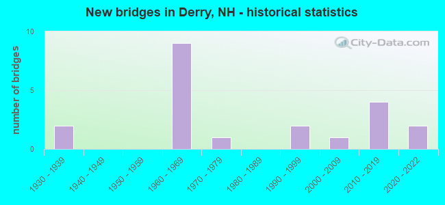
- New bridges - historical statistics
- 21930-1939
- 91960-1969
- 11970-1979
- 21990-1999
- 12000-2009
- 42010-2019
- 22020-2022
FCC Registered Antenna Towers: 76 (See the full list of FCC Registered Antenna Towers)
FCC Registered Private Land Mobile Towers: 4 (See the full list of FCC Registered Private Land Mobile Towers in Derry, NH)
FCC Registered Broadcast Land Mobile Towers: 28 (See the full list of FCC Registered Broadcast Land Mobile Towers)
FCC Registered Microwave Towers: 21 (See the full list of FCC Registered Microwave Towers in this town)
FCC Registered Paging Towers: 4 (See the full list of FCC Registered Paging Towers)
FCC Registered Amateur Radio Licenses: 318 (See the full list of FCC Registered Amateur Radio Licenses in Derry)
FAA Registered Aircraft: 17 (See the full list of FAA Registered Aircraft in Derry)
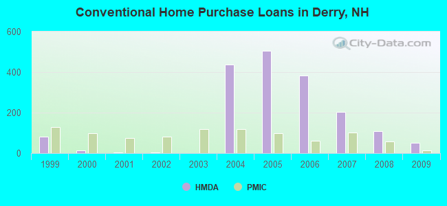
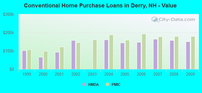
| Home Mortgage Disclosure Act Aggregated Statistics For Year 2009 (Based on 2 full and 4 partial tracts) | ||||||||||||||
| A) FHA, FSA/RHS & VA Home Purchase Loans | B) Conventional Home Purchase Loans | C) Refinancings | D) Home Improvement Loans | E) Loans on Dwellings For 5+ Families | F) Non-occupant Loans on < 5 Family Dwellings (A B C & D) | G) Loans On Manufactured Home Dwelling (A B C & D) | ||||||||
|---|---|---|---|---|---|---|---|---|---|---|---|---|---|---|
| Number | Average Value | Number | Average Value | Number | Average Value | Number | Average Value | Number | Average Value | Number | Average Value | Number | Average Value | |
| LOANS ORIGINATED | 87 | $176,721 | 52 | $150,099 | 300 | $183,305 | 18 | $63,227 | 1 | $248,000 | 14 | $126,012 | 3 | $56,597 |
| APPLICATIONS APPROVED, NOT ACCEPTED | 6 | $188,445 | 5 | $121,268 | 32 | $178,160 | 4 | $29,130 | 1 | $2,000,000 | 2 | $83,010 | 0 | $0 |
| APPLICATIONS DENIED | 26 | $151,878 | 23 | $132,783 | 163 | $194,210 | 17 | $45,188 | 0 | $0 | 12 | $171,738 | 6 | $87,597 |
| APPLICATIONS WITHDRAWN | 11 | $182,696 | 8 | $146,789 | 77 | $196,645 | 1 | $99,530 | 0 | $0 | 4 | $135,428 | 0 | $0 |
| FILES CLOSED FOR INCOMPLETENESS | 2 | $233,960 | 2 | $188,865 | 19 | $215,718 | 2 | $76,505 | 0 | $0 | 0 | $0 | 0 | $0 |
Detailed HMDA statistics for the following Tracts: 0033.01 , 0033.02, 0034.00, 0035.00, 0036.01, 0036.02
| Private Mortgage Insurance Companies Aggregated Statistics For Year 2009 (Based on 2 full and 4 partial tracts) | ||||
| A) Conventional Home Purchase Loans | B) Refinancings | |||
|---|---|---|---|---|
| Number | Average Value | Number | Average Value | |
| LOANS ORIGINATED | 13 | $179,361 | 4 | $186,542 |
| APPLICATIONS APPROVED, NOT ACCEPTED | 6 | $188,280 | 2 | $308,615 |
| APPLICATIONS DENIED | 4 | $157,980 | 1 | $284,360 |
| APPLICATIONS WITHDRAWN | 0 | $0 | 1 | $271,670 |
| FILES CLOSED FOR INCOMPLETENESS | 1 | $120,020 | 0 | $0 |
Detailed PMIC statistics for the following Tracts: 0033.01 , 0033.02, 0034.00, 0035.00, 0036.01, 0036.02
2002 - 2018 National Fire Incident Reporting System (NFIRS) incidents
- Fire incident types reported to NFIRS in Derry, NH
- 88946.7%Structure Fires
- 74539.2%Outside Fires
- 20710.9%Mobile Property/Vehicle Fires
- 613.2%Other
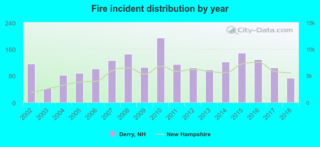 Based on the data from the years 2002 - 2018 the average number of fire incidents per year is 112. The highest number of fires - 194 took place in 2010, and the least - 42 in 2003. The data has a decreasing trend.
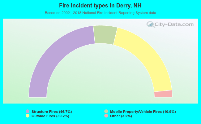 When looking into fire subcategories, the most reports belonged to: Structure Fires (46.7%), and Outside Fires (39.2%).
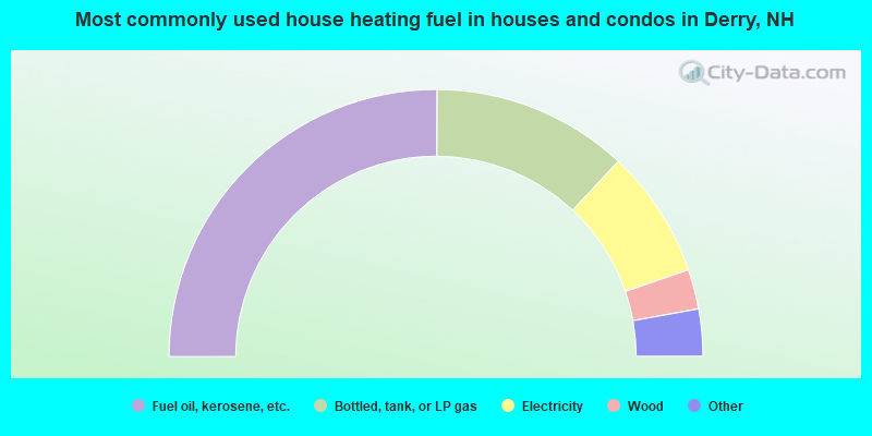
- 50.2%Fuel oil, kerosene, etc.
- 23.8%Bottled, tank, or LP gas
- 15.6%Electricity
- 4.8%Wood
- 3.0%Other fuel
- 2.4%Utility gas
- 0.3%No fuel used
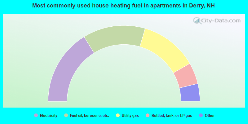
- 32.4%Electricity
- 26.6%Fuel oil, kerosene, etc.
- 24.4%Utility gas
- 9.1%Bottled, tank, or LP gas
- 3.6%No fuel used
- 2.0%Other fuel
- 1.3%Wood
- 0.5%Coal or coke
Derry compared to New Hampshire state average:
- Unemployed percentage significantly below state average.
- Black race population percentage significantly below state average.
- Median age below state average.
- Length of stay since moving in significantly above state average.
Derry on our top lists:
- #101 on the list of "Top 101 cities with largest percentage of males in industries: broadcasting, internet publishing, and telecommunications services (population 5,000+)"
- #101 on the list of "Top 101 cities with largest percentage of females in industries: broadcasting, internet publishing, and telecommunications services (population 5,000+)"
- #101 on the list of "Top 101 cities with largest percentage of males in industries: wholesale electronic markets and agents and brokers (population 5,000+)"
- #101 on the list of "Top 101 cities with largest percentage of females in industries: wholesale electronic markets and agents and brokers (population 5,000+)"
- #9 on the list of "Top 101 counties with the largest decrease in the number of births per 1000 residents 2000-2006 to 2007-2013 (pop 50,000+)"
- #14 on the list of "Top 101 counties with the best general health status score of residents (1-5), 3 years of data"
- #16 on the list of "Top 101 counties with the lowest number of births per 1000 residents 2007-2013"
- #22 on the list of "Top 101 counties with the lowest Particulate Matter (PM10) Annual air pollution readings in 2012 (µg/m3)"
- #36 on the list of "Top 101 counties with the highest percentage of residents that visited a dentist within the past year"

|
|
Total of 353 patent applications in 2008-2024.