Empire, Alabama
Submit your own pictures of this place and show them to the world
- OSM Map
- General Map
- Google Map
- MSN Map

| Males: 1,237 | |
| Females: 1,282 |
| Median resident age: | 35.1 years |
| Alabama median age: | 35.8 years |
Zip code: 35063
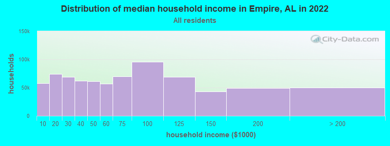
| Empire: | $46,919 |
| AL: | $59,674 |
Estimated per capita income in 2022: $27,429 (it was $14,925 in 2000)
Empire CCD income, earnings, and wages data
Estimated median house or condo value in 2022: $110,728 (it was $44,300 in 2000)
| Empire: | $110,728 |
| AL: | $200,900 |
Detailed information about poverty and poor residents in Empire, AL
Compare current foreclosures near Empire, AL:
| Photo | Address | Area | Beds / Baths | Price | Details |
|---|---|---|---|---|---|

|
#1
Higginbotham Rd
Empire, AL 35063
|
- sq. feet
|
2 baths 3 beds |
$101,100
|
show details |

|
#2
York Mountain Rd
Empire, AL 35063
|
- sq. feet
|
- baths - beds |
show details | |

|
#3
Blue Bird Ln
Empire, AL 35063
|
- sq. feet
|
- baths - beds |
show details | |

|
#4
Clark St
Empire, AL 35063
|
- sq. feet
|
- baths - beds |
show details | |

|
#5
Coon Creek Rd
Empire, AL 35063
|
- sq. feet
|
- baths - beds |
show details | |

|
#6
County Line Rd
Empire, AL 35063
|
- sq. feet
|
- baths - beds |
show details | |

|
#7
Hill Rd
Empire, AL 35063
|
- sq. feet
|
- baths - beds |
show details | |

|
#8
Old Town Rd
Empire, AL 35063
|
- sq. feet
|
- baths - beds |
show details | |

|
#9
Boyd Rd
Empire, AL 35063
|
- sq. feet
|
- baths - beds |
show details | |

|
#10
Shipptown Rd
Empire, AL 35063
|
- sq. feet
|
- baths - beds |
show details |
| Photo | Address | Area | Beds / Baths | Price | Details |
|---|---|---|---|---|---|

|
#11
Rutledge Dr
Jasper, AL 35504
|
2,156 sq. feet
|
2 baths 3 beds |
$352,000
|
show details |

|
#12
Warrior Trafford Rd
Trafford, AL 35172
|
1,040 sq. feet
|
1 baths 3 beds |
$147,500
|
show details |

|
#13
Jacobs St
Graysville, AL 35073
|
1,232 sq. feet
|
2 baths 2 beds |
$26,000
|
show details |

|
#14
8th Ave
Jasper, AL 35501
|
1,340 sq. feet
|
1 baths 3 beds |
show details | |

|
#15
Golf Course Rd
Jasper, AL 35504
|
2,088 sq. feet
|
2 baths 4 beds |
show details | |

|
#16
Charter Cir
Jasper, AL 35504
|
1,664 sq. feet
|
2 baths 3 beds |
show details | |

|
#17
Northfield Dr
Jasper, AL 35504
|
1,721 sq. feet
|
3 baths 3 beds |
show details | |

|
#18
Mulberry St
Jasper, AL 35503
|
1,090 sq. feet
|
2 baths 3 beds |
show details | |

|
#19
Sutherland Rd
Mount Olive, AL 35117
|
1,509 sq. feet
|
1 baths 3 beds |
show details | |

|
#20
Woodruff Mill Rd
Adamsville, AL 35005
|
- sq. feet
|
2 baths 3 beds |
show details |
| Photo | Address | Area | Beds / Baths | Price | Details |
|---|---|---|---|---|---|

|
#21
Knollcrest Ln
Adamsville, AL 35005
|
1,490 sq. feet
|
2 baths 3 beds |
show details | |

|
#22
Crawford Rd
Mount Olive, AL 35117
|
1,421 sq. feet
|
1 baths 3 beds |
show details | |

|
#23
Mount Olive Rd
Mount Olive, AL 35117
|
3,528 sq. feet
|
2 baths 4 beds |
show details | |

|
#24
Meadowview Ln
Mount Olive, AL 35117
|
2,602 sq. feet
|
2 baths 3 beds |
show details | |

|
#25
Summer Cir
Morris, AL 35116
|
1,831 sq. feet
|
2 baths 3 beds |
show details | |

|
#26
Meadowview Ln
Mount Olive, AL 35117
|
1,492 sq. feet
|
2 baths 3 beds |
show details | |

|
#27
Posey Rd
Morris, AL 35116
|
1,421 sq. feet
|
1 baths 3 beds |
show details | |

|
#28
Mountainview Cir
Gardendale, AL 35071
|
2,430 sq. feet
|
2 baths 2 beds |
show details | |

|
#29
Ridge Way
Kimberly, AL 35091
|
2,199 sq. feet
|
3 baths 3 beds |
show details | |

|
#30
Murray Ln
Mount Olive, AL 35117
|
1,624 sq. feet
|
1 baths 4 beds |
show details |
| Photo | Address | Area | Beds / Baths | Price | Details |
|---|---|---|---|---|---|

|
#31
Holly Dr
Adamsville, AL 35005
|
1,462 sq. feet
|
2 baths 3 beds |
show details | |

|
#32
Foxfire Dr
Gardendale, AL 35071
|
1,008 sq. feet
|
1 baths 3 beds |
show details | |

|
#33
5th Pl NE
Graysville, AL 35073
|
896 sq. feet
|
1 baths 2 beds |
show details | |

|
#34
North Rd
Gardendale, AL 35071
|
1,176 sq. feet
|
1 baths 2 beds |
show details | |

|
#35
Scenic Dr
Gardendale, AL 35071
|
1,920 sq. feet
|
2 baths 3 beds |
show details | |

|
#36
Scenic Dr
Gardendale, AL 35071
|
2,016 sq. feet
|
3 baths 3 beds |
show details | |

|
#37
Center St
Quinton, AL 35130
|
1,176 sq. feet
|
1 baths 3 beds |
show details | |

|
#38
Kennedy Rd
Gardendale, AL 35071
|
1,248 sq. feet
|
2 baths 3 beds |
show details | |

|
#39
5th St SW
Graysville, AL 35073
|
1,847 sq. feet
|
2 baths 3 beds |
show details | |

|
#40
Kimberly Ave
Gardendale, AL 35071
|
1,120 sq. feet
|
1 baths 3 beds |
show details |
| Photo | Address | Area | Beds / Baths | Price | Details |
|---|---|---|---|---|---|

|
#41
Hodges Cemetary Dr
Mount Olive, AL 35117
|
1,824 sq. feet
|
1 baths 3 beds |
show details | |

|
#42
Powers Cir
Mount Olive, AL 35117
|
1,596 sq. feet
|
2 baths 3 beds |
show details | |

|
#43
Church St
Warrior, AL 35180
|
1,454 sq. feet
|
1 baths 3 beds |
show details | |

|
#44
Radford Pl
Warrior, AL 35180
|
1,802 sq. feet
|
2 baths 3 beds |
show details | |

|
#45
Kilgore Church Rd
Dora, AL 35062
|
1,125 sq. feet
|
1 baths 3 beds |
show details | |

|
#46
Panola Trl
Warrior, AL 35180
|
1,217 sq. feet
|
2 baths 3 beds |
show details | |

|
#47
Kilgore Church Rd
Dora, AL 35062
|
1,308 sq. feet
|
1 baths 3 beds |
show details | |

|
#48
Plateau Dr
Gardendale, AL 35071
|
1,318 sq. feet
|
2 baths 3 beds |
show details | |

|
#49
Dana Rd
Warrior, AL 35180
|
1,508 sq. feet
|
1 baths 3 beds |
show details | |

|
Check over 1 million property listings on Foreclosure.com!
|
browse all offers | |||

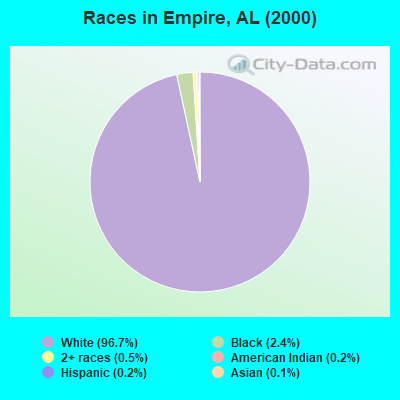
- 2,50896.7%White alone
- 612.4%Black alone
- 140.5%Two or more races
- 40.2%American Indian alone
- 40.2%Hispanic
- 30.1%Asian alone
According to our research of Alabama and other state lists, there were 17 registered sex offenders living in Empire, Alabama as of April 24, 2024.
The ratio of all residents to sex offenders in Empire is 148 to 1.
 Recent articles from our blog. Our writers, many of them Ph.D. graduates or candidates, create easy-to-read articles on a wide variety of topics.
Current Local Time: CST time zone
Elevation: 505 feet
Land area: 36.9 square miles.
Population density: 68 people per square mile (very low).

| Empire CCD: | 0.4% ($199) |
| Alabama: | 0.4% ($289) |
Nearest city with pop. 50,000+: Birmingham, AL  (24.2 miles , pop. 242,820).
Nearest city with pop. 1,000,000+: Chicago, IL (555.0 miles , pop. 2,896,016).
Nearest cities:
), ), ), ), Latitude: 33.83 N, Longitude: 87.01 W
Area code commonly used in this area: 205

| Here: | 2.7% |
| Alabama: | 2.6% |
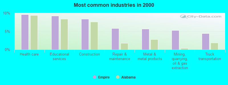
- Health care (9.6%)
- Educational services (9.2%)
- Construction (8.4%)
- Repair & maintenance (5.8%)
- Metal & metal products (5.7%)
- Mining, quarrying, oil & gas extraction (5.2%)
- Truck transportation (4.5%)
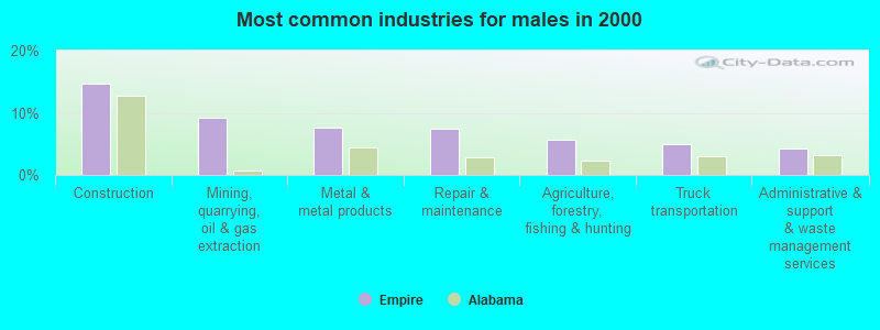
- Construction (14.7%)
- Mining, quarrying, oil & gas extraction (9.2%)
- Metal & metal products (7.6%)
- Repair & maintenance (7.4%)
- Agriculture, forestry, fishing & hunting (5.7%)
- Truck transportation (4.9%)
- Administrative & support & waste management services (4.3%)
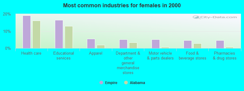
- Health care (19.1%)
- Educational services (16.5%)
- Apparel (5.4%)
- Department & other general merchandise stores (5.2%)
- Motor vehicle & parts dealers (5.2%)
- Food & beverage stores (4.7%)
- Pharmacies & drug stores (4.7%)

- Driver/sales workers and truck drivers (7.3%)
- Vehicle and mobile equipment mechanics, installers, and repairers (5.7%)
- Secretaries and administrative assistants (5.1%)
- Other sales and related occupations, including supervisors (4.8%)
- Material recording, scheduling, dispatching, and distributing workers (4.8%)
- Metal workers and plastic workers (4.7%)
- Preschool, kindergarten, elementary, and middle school teachers (4.1%)
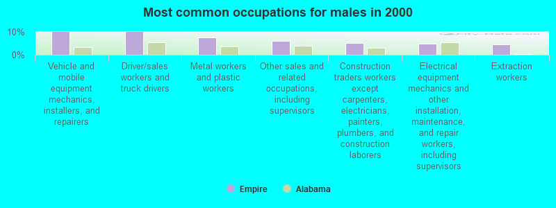
- Vehicle and mobile equipment mechanics, installers, and repairers (10.0%)
- Driver/sales workers and truck drivers (10.0%)
- Metal workers and plastic workers (7.4%)
- Other sales and related occupations, including supervisors (6.1%)
- Construction traders workers except carpenters, electricians, painters, plumbers, and construction laborers (5.1%)
- Electrical equipment mechanics and other installation, maintenance, and repair workers, including supervisors (4.9%)
- Extraction workers (4.5%)

- Secretaries and administrative assistants (11.9%)
- Preschool, kindergarten, elementary, and middle school teachers (8.0%)
- Material recording, scheduling, dispatching, and distributing workers (7.0%)
- Registered nurses (6.5%)
- Teachers, secondary school (6.5%)
- Information and record clerks, except customer service representatives (5.7%)
- Cashiers (4.4%)
Average climate in Empire, Alabama
Based on data reported by over 4,000 weather stations


(lower is better)
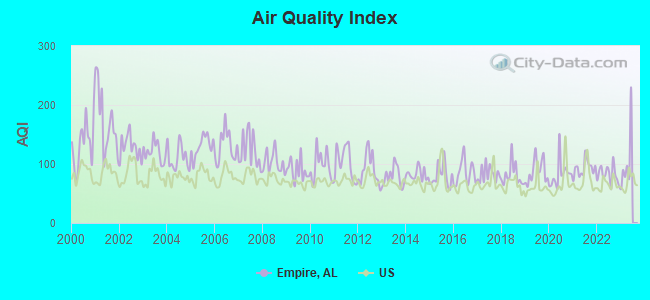
Air Quality Index (AQI) level in 2022 was 82.0. This is about average.
| City: | 82.0 |
| U.S.: | 72.6 |
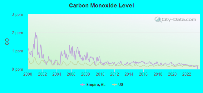
Carbon Monoxide (CO) [ppm] level in 2022 was 0.192. This is better than average. Closest monitor was 22.2 miles away from the city center.
| City: | 0.192 |
| U.S.: | 0.251 |
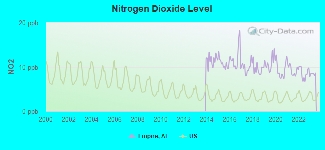
Nitrogen Dioxide (NO2) [ppb] level in 2022 was 8.54. This is significantly worse than average. Closest monitor was 22.1 miles away from the city center.
| City: | 8.54 |
| U.S.: | 5.11 |
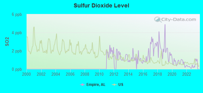
Sulfur Dioxide (SO2) [ppb] level in 2022 was 0.254. This is significantly better than average. Closest monitor was 22.1 miles away from the city center.
| City: | 0.254 |
| U.S.: | 1.515 |
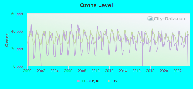
Ozone [ppb] level in 2022 was 29.3. This is about average. Closest monitor was 4.4 miles away from the city center.
| City: | 29.3 |
| U.S.: | 33.3 |
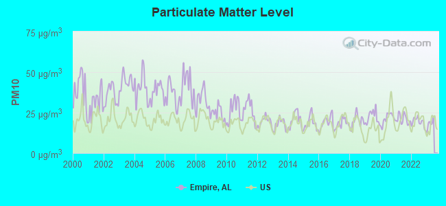
Particulate Matter (PM10) [µg/m3] level in 2022 was 19.1. This is about average. Closest monitor was 4.4 miles away from the city center.
| City: | 19.1 |
| U.S.: | 19.2 |
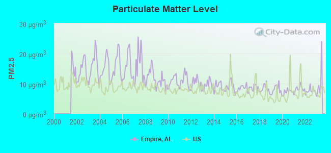
Particulate Matter (PM2.5) [µg/m3] level in 2022 was 7.56. This is about average. Closest monitor was 4.4 miles away from the city center.
| City: | 7.56 |
| U.S.: | 8.11 |
Tornado activity:
Empire-area historical tornado activity is slightly above Alabama state average. It is 170% greater than the overall U.S. average.
On 4/8/1998, a category F5 (max. wind speeds 261-318 mph) tornado 19.3 miles away from the Empire place center killed 32 people and injured 259 people and caused $200 million in damages.
On 4/4/1977, a category F5 tornado 22.2 miles away from the place center killed 22 people and injured 130 people and caused between $5,000,000 and $50,000,000 in damages.
Earthquake activity:
Empire-area historical earthquake activity is significantly above Alabama state average. It is 150% greater than the overall U.S. average.On 1/18/1999 at 07:00:53, a magnitude 4.8 (4.8 MB, 4.0 LG, Depth: 0.6 mi, Class: Light, Intensity: IV - V) earthquake occurred 32.9 miles away from Empire center
On 4/29/2003 at 08:59:39, a magnitude 4.9 (4.4 MB, 4.6 MW, 4.9 LG) earthquake occurred 91.2 miles away from the city center
On 6/24/1975 at 11:11:36, a magnitude 4.5 (4.5 MB) earthquake occurred 48.4 miles away from the city center
On 4/29/2003 at 08:59:39, a magnitude 4.6 (4.6 MW, Depth: 12.3 mi) earthquake occurred 91.2 miles away from Empire center
On 10/24/1997 at 08:35:17, a magnitude 4.9 (4.8 MB, 4.2 MS, 4.9 LG, Depth: 6.2 mi) earthquake occurred 188.1 miles away from Empire center
On 3/25/1976 at 00:41:20, a magnitude 5.0 (4.9 MB, 5.0 LG, Class: Moderate, Intensity: VI - VII) earthquake occurred 226.1 miles away from Empire center
Magnitude types: regional Lg-wave magnitude (LG), body-wave magnitude (MB), surface-wave magnitude (MS), moment magnitude (MW)
Natural disasters:
The number of natural disasters in Walker County (21) is greater than the US average (15).Major Disasters (Presidential) Declared: 13
Emergencies Declared: 5
Causes of natural disasters: Storms: 12, Tornadoes: 10, Floods: 9, Winds: 5, Hurricanes: 3, Drought: 1, Fire: 1, Snowfall: 1, Winter Storm: 1, Other: 1 (Note: some incidents may be assigned to more than one category).
Hospitals and medical centers near Empire:
- SOUTHEAST HOSPICE NETWORK, LLC (Hospital, about 9 miles away; JASPER, AL)
- CORDOVA HEALTH AND REHABILITATION, LLC (Nursing Home, about 12 miles away; CORDOVA, AL)
- RCG WALKER (Dialysis Facility, about 14 miles away; JASPER, AL)
- WALKER BAPTIST MEDICAL CENTER Acute Care Hospitals (about 14 miles away; JASPER, AL)
- MID-SOUTH HOME HEALTH AGENCY INC (Home Health Center, about 14 miles away; JASPER, AL)
- LONGVIEW GENERAL HOSPITAL (Hospital, about 14 miles away; GRAYSVILLE, AL)
- AMEDISYS HOME HEALTH OF WALKER (Home Health Center, about 16 miles away; JASPER, AL)
Colleges/universities with over 2000 students nearest to Empire:
- Bevill State Community College (about 15 miles; Jasper, AL; Full-time enrollment: 2,970)
- George C Wallace State Community College-Hanceville (about 22 miles; Hanceville, AL; FT enrollment: 4,486)
- Jefferson State Community College (about 22 miles; Birmingham, AL; FT enrollment: 6,041)
- University of Alabama at Birmingham (about 26 miles; Birmingham, AL; FT enrollment: 14,853)
- Lawson State Community College-Birmingham Campus (about 28 miles; Birmingham, AL; FT enrollment: 2,695)
- Virginia College-Birmingham (about 28 miles; Birmingham, AL; FT enrollment: 8,167)
- Samford University (about 29 miles; Birmingham, AL; FT enrollment: 3,829)
Points of interest:
Notable locations in Empire: Gravlee Junction (A), Empire Volunteer Fire Department (B). Display/hide their locations on the map
Churches in Empire include: Mount Hope Church (A), Rices Chapel (B), New Canaan Church (C), Phillips Church (D), Union Grove Baptist Church (E), Empire Church (F), Owens Chapel Church (G), Little Vine Church (H). Display/hide their locations on the map
Cemeteries: New Canaan Cemetery (1), Phillips Cemetery (2), Mauldin Cemetery (3). Display/hide their locations on the map
Reservoirs: Little Creek Mine Lake (A), Lake Grey (B). Display/hide their locations on the map
Streams, rivers, and creeks: Pinhook Creek (A), No Business Creek (B), Mullen Branch (C), Sloan Creek (D), Little Creek (E), Leeth Creek (F), Jim Light Branch (G), Dorsey Creek (H), Clark Branch (I). Display/hide their locations on the map
Park in Empire: Hollow Hills Park (1). Display/hide its location on the map
Birthplace of: Dan Bankhead - Baseball player.
| This place: | 2.6 people |
| Alabama: | 2.5 people |
| This place: | 73.1% |
| Whole state: | 67.8% |
| This place: | 5.0% |
| Whole state: | 4.7% |
Likely homosexual households (counted as self-reported same-sex unmarried-partner households)
- Lesbian couples: 0.5% of all households
- Gay men: 0.3% of all households
| This place: | 16.4% |
| Whole state: | 16.1% |
| This place: | 10.1% |
| Whole state: | 7.3% |
For population 15 years and over in Empire:
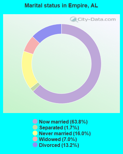
- Never married: 16.0%
- Now married: 63.8%
- Separated: 1.7%
- Widowed: 7.0%
- Divorced: 13.2%
For population 25 years and over in Empire:
- High school or higher: 57.0%
- Bachelor's degree or higher: 5.3%
- Graduate or professional degree: 2.5%
- Unemployed: 6.0%
- Mean travel time to work (commute): 41.0 minutes
| Here: | 15.7 |
| Alabama average: | 13.2 |
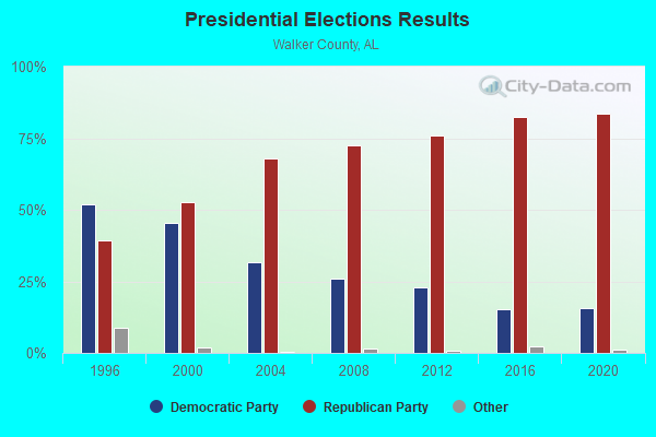
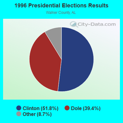
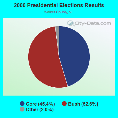
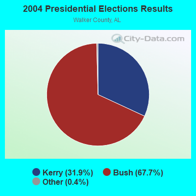

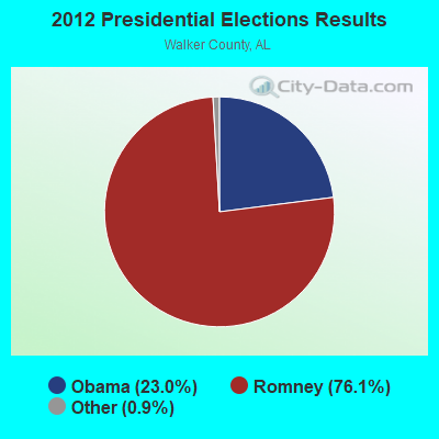
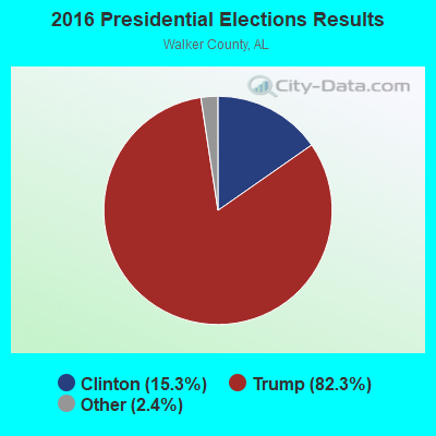
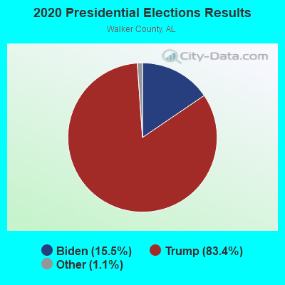
Graphs represent county-level data. Detailed 2008 Election Results
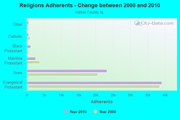
Religion statistics for Empire, AL (based on Walker County data)
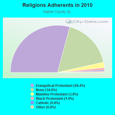
| Religion | Adherents | Congregations |
|---|---|---|
| Evangelical Protestant | 39,118 | 180 |
| Mainline Protestant | 2,552 | 25 |
| Black Protestant | 1,087 | 8 |
| Catholic | 523 | 1 |
| Other | 520 | 3 |
| None | 23,223 | - |
Food Environment Statistics:
| Here: | 2.48 / 10,000 pop. |
| Alabama: | 1.89 / 10,000 pop. |
| Walker County: | 0.29 / 10,000 pop. |
| State: | 0.20 / 10,000 pop. |
| Here: | 0.44 / 10,000 pop. |
| State: | 0.65 / 10,000 pop. |
| Walker County: | 6.41 / 10,000 pop. |
| State: | 6.32 / 10,000 pop. |
| Here: | 5.39 / 10,000 pop. |
| Alabama: | 5.75 / 10,000 pop. |
| This county: | 11.9% |
| Alabama: | 11.8% |
| Walker County: | 32.4% |
| State: | 31.7% |
| Walker County: | 16.5% |
| Alabama: | 13.5% |
Strongest AM radio stations in Empire:
- WDJC (850 AM; 50 kW; BIRMINGHAM, AL; Owner: KIMTRON, INC.)
- WCOC (1010 AM; 5 kW; DORA, AL; Owner: AZTECA COMMUNICATIONS OF ALABAMA, INC.)
- WAPI (1070 AM; 50 kW; BIRMINGHAM, AL; Owner: CITADEL BROADCASTING COMPANY)
- WJOX (690 AM; 50 kW; BIRMINGHAM, AL; Owner: CITADEL BROADCASTING COMPANY)
- WNSI (810 AM; 50 kW; JACKSONVILLE, AL; Owner: UNITED BROADCASTING NETWORK, INC.)
- WERC (960 AM; 5 kW; BIRMINGHAM, AL; Owner: CAPSTAR TX LIMITED PARTNERSHIP)
- WRJS (1320 AM; 5 kW; BIRMINGHAM, AL; Owner: CXR HOLDINGS, INC.)
- WLOR (1550 AM; 50 kW; HUNTSVILLE, AL; Owner: BCA RADIO, LLC)
- WYDE (1260 AM; 5 kW; BIRMINGHAM, AL; Owner: KIMTRON, INC.)
- WMCJ (1460 AM; 5 kW; CULLMAN, AL)
- WKNG (1060 AM; daytime; 50 kW; TALLAPOOSA, GA; Owner: WKNG, INC.)
- WLPH (1480 AM; daytime; 5 kW; IRONDALE, AL; Owner: BIRMINGHAM CHRISTIAN RADIO, INC.)
- WWAM (820 AM; daytime; 50 kW; JASPER, TN; Owner: SHELTON BROADCASTING SYSTEM)
Strongest FM radio stations in Empire:
- WYDE-FM (101.1 FM; CULLMAN, AL; Owner: KIMTRON, INC.)
- WRAX (107.7 FM; BIRMINGHAM, AL; Owner: CITADEL BROADCASTING COMPANY)
- WDXB (102.5 FM; JASPER, AL; Owner: CAPSTAR TX LIMITED PARTNERSHIP)
- WBHK (98.7 FM; WARRIOR, AL; Owner: CXR HOLDINGS, INC.)
- WBPT (106.9 FM; BIRMINGHAM, AL; Owner: CXR HOLDINGS, INC.)
- WZZK-FM (104.7 FM; BIRMINGHAM, AL; Owner: CXR HOLDINGS, INC.)
- WODL (97.3 FM; HOMEWOOD, AL; Owner: CXR HOLDINGS, INC.)
- WBHM (90.3 FM; BIRMINGHAM, AL; Owner: BD OF TRUSTEES/U OF AL AT BIRMINGHAM)
- WYSF (94.5 FM; BIRMINGHAM, AL; Owner: CITADEL BROADCASTING COMPANY)
- WQOP-FM (92.5 FM; DORA, AL; Owner: QUEEN OF PEACE RADIO, INC.)
- WMJJ (96.5 FM; BIRMINGHAM, AL; Owner: CAPSTAR TX LIMITED PARTNERSHIP)
- WQEN (103.7 FM; GADSDEN, AL; Owner: CAPSTAR TX LIMITED PARTNERSHIP)
- WFFN (95.3 FM; CORDOVA, AL; Owner: NEW CENTURY RADIO, INC.)
- WZRR (99.5 FM; BIRMINGHAM, AL; Owner: CITADEL BROADCASTING COMPANY)
- WDJC-FM (93.7 FM; BIRMINGHAM, AL; Owner: KIMTRON, INC.)
- WENN (105.9 FM; TRUSSVILLE, AL; Owner: CAPSTAR TX LIMITED PARTNERSHIP)
- WBFR (89.5 FM; BIRMINGHAM, AL; Owner: FAMILY STATIONS, INC.)
- WGIB (91.9 FM; BIRMINGHAM, AL; Owner: GLEN IRIS BAPTIST SCHOOL)
- W281AB (104.1 FM; MOUNTAIN BROOK, AL; Owner: FAMILY STATIONS, INC.)
TV broadcast stations around Empire:
- W23AK (Channel 23; JASPER, AL; Owner: WMTY, INC.)
- WDBB (Channel 17; BESSEMER, AL; Owner: WDBB-TV, INC.)
- WCFT-TV (Channel 33; TUSCALOOSA, AL; Owner: TV ALABAMA, INCORPORATED)
- WIAT (Channel 42; BIRMINGHAM, AL; Owner: MEDIA GENERAL COMMUNICATIONS, INC.)
- WBIQ (Channel 10; BIRMINGHAM, AL; Owner: ALABAMA EDUCATIONAL TELEVISION COMMISSION)
- WTTO (Channel 21; HOMEWOOD, AL; Owner: WTTO LICENSEE, LLC)
- WBRC (Channel 6; BIRMINGHAM, AL; Owner: WBRC LICENSE, INC.)
- WABM (Channel 68; BIRMINGHAM, AL; Owner: BIRMINGHAM (WABM-TV) LICENSEE, INC.)
- WVTM-TV (Channel 13; BIRMINGHAM, AL; Owner: BIRMINGHAM BROADCASTING (WVTM-TV), LLC)
- W55BJ (Channel 55; JASPER, AL; Owner: COMBS BROADCASTING, INC.)
- W66CN (Channel 66; JASPER, AL; Owner: TRINITY BROADCASTING NETWORK)
- WBXA-CA (Channel 2; BIRMINGHAM, AL; Owner: THE BOX WORLDWIDE LLC)
- W27CM (Channel 27; BIRMINGHAM, AL; Owner: EQUITY BROADCASTING CORPORATION)
- W46DK (Channel 46; BIRMINGHAM, AL; Owner: TRINITY BROADCASTING NETWORK)
- WTJP (Channel 60; GADSDEN, AL; Owner: TRINITY BROADCASTING NETWORK)
- WBMA-LP (Channel 58; BIRMINGHAM, AL; Owner: TV ALABAMA, INC.)
- National Bridge Inventory (NBI) Statistics
- 3Number of bridges
- 30ft / 9.5mTotal length
- $2,498,000Total costs
- 1,506Total average daily traffic
- 89Total average daily truck traffic
- 2,200Total future (year 2033) average daily traffic
FCC Registered Antenna Towers:
11 (See the full list of FCC Registered Antenna Towers in Empire)FCC Registered Microwave Towers:
1- 9BH8167A, Hill Rd (Lat: 33.805250 Lon: -87.001889), Type: Gtower, Structure height: 91.4 m, Call Sign: WRYJ269,
Assigned Frequencies: 11075.0 MHz, 11075.0 MHz, 11075.0 MHz, 11075.0 MHz, 11075.0 MHz, 11075.0 MHz, 11075.0 MHz, 11075.0 MHz, 11075.0 MHz, 11075.0 MHz, 11075.0 MHz, Grant Date: 08/16/2023, Expiration Date: 08/16/2033, Certifier: Jenny Knopf, Registrant: T-Mobile Usa, Inc., 12920 Se 38th Street, Bellevue, WA 98006, Phone: (425) 383-8401, Fax: (425) 383-4040, Email:
FCC Registered Amateur Radio Licenses:
14 (See the full list of FCC Registered Amateur Radio Licenses in Empire)2003 - 2018 National Fire Incident Reporting System (NFIRS) incidents
- Fire incident types reported to NFIRS in Empire, AL
- 15145.2%Outside Fires
- 10732.0%Structure Fires
- 5616.8%Other
- 206.0%Mobile Property/Vehicle Fires
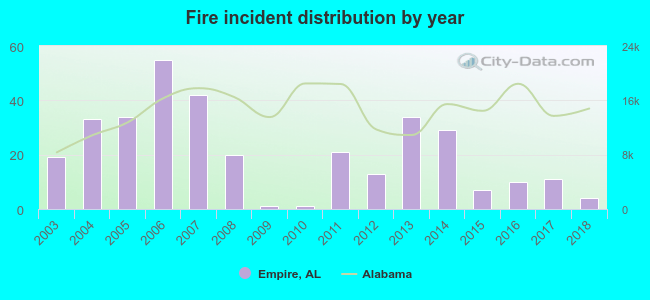 According to the data from the years 2003 - 2018 the average number of fires per year is 21. The highest number of fire incidents - 55 took place in 2006, and the least - 1 in 2009. The data has a declining trend.
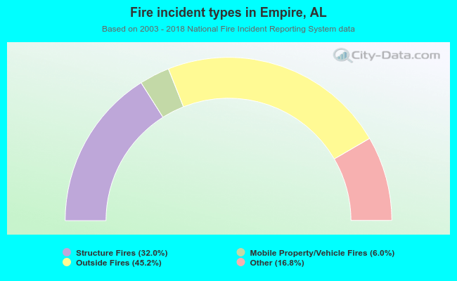 When looking into fire subcategories, the most incidents belonged to: Outside Fires (45.2%), and Structure Fires (32.0%).
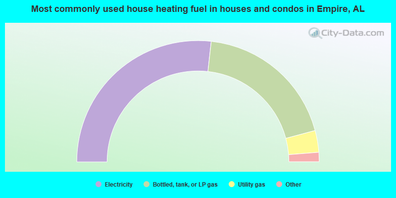
- 53.5%Electricity
- 38.2%Bottled, tank, or LP gas
- 5.8%Utility gas
- 1.9%Wood
- 0.6%Fuel oil, kerosene, etc.
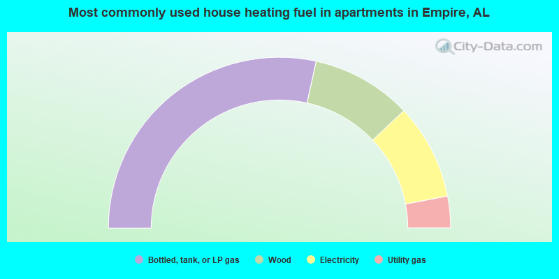
- 56.9%Bottled, tank, or LP gas
- 19.0%Wood
- 18.1%Electricity
- 6.0%Utility gas
Empire compared to Alabama state average:
- Median house value below state average.
- Unemployed percentage below state average.
- Black race population percentage significantly below state average.
- Hispanic race population percentage significantly below state average.
- Median age below state average.
- Foreign-born population percentage significantly below state average.
- Renting percentage below state average.
- Length of stay since moving in significantly above state average.
- Number of rooms per house significantly below state average.
- House age significantly below state average.
- Number of college students significantly below state average.
- Percentage of population with a bachelor's degree or higher significantly below state average.

|
Total of 2 patent applications in 2008-2024.