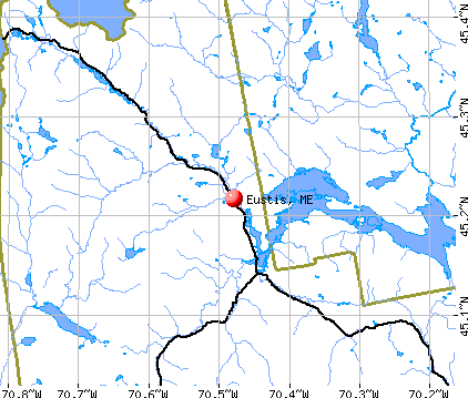
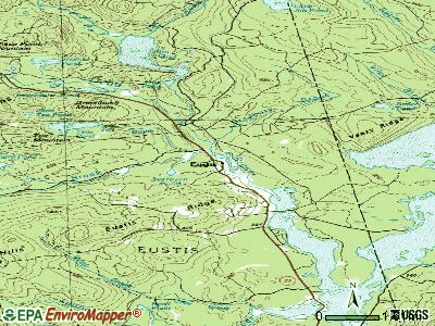
Eustis, Maine

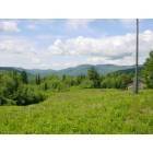
Eustis: From Eustis Ridge
Eustis: Off the grid pastoral paradise !

Eustis

Eustis: Gold in the north country-23madileen lane,eustis

Eustis: Breathtaking views in Eustis~

Eustis: Breathtaking views in Eustis~

Eustis: Dawn from my house on Eustis Ridge over Bigelow Range

Eustis: Flagstaff Lake~

Eustis: Eustis Ridge~Eustis, Maine
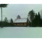
Eustis: fresh snow on our cabin. we madileen lane, eustis
- add
your
Submit your own pictures of this town and show them to the world
- OSM Map
- General Map
- Google Map
- MSN Map
Population change since 2000: -9.8%
 |
| Males: 326 | |
| Females: 292 |
| Median resident age: | 49.4 years |
| Maine median age: | 43.0 years |
Zip codes: 04936.
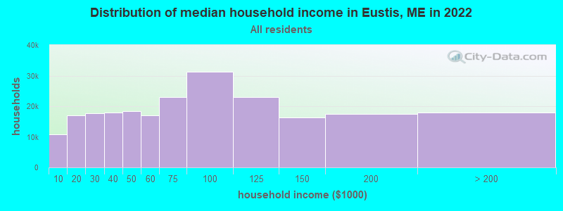
| Eustis: | $51,593 |
| ME: | $69,543 |
Estimated per capita income in 2022: $28,898 (it was $13,274 in 2000)
Eustis town income, earnings, and wages data
Estimated median house or condo value in 2022: $204,110 (it was $76,900 in 2000)
| Eustis: | $204,110 |
| ME: | $290,600 |
Mean prices in 2022: all housing units: $249,382; detached houses: $272,823; townhouses or other attached units: $269,365; in 2-unit structures: $215,792; in 3-to-4-unit structures: $159,774; in 5-or-more-unit structures: $237,338; mobile homes: $71,957
Detailed information about poverty and poor residents in Eustis, ME


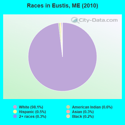
- 60698.1%White alone
- 40.6%American Indian alone
- 30.5%Hispanic
- 20.3%Asian alone
- 20.3%Two or more races
- 10.2%Black alone
Races in Eustis detailed stats: ancestries, foreign born residents, place of birth
 Recent articles from our blog. Our writers, many of them Ph.D. graduates or candidates, create easy-to-read articles on a wide variety of topics.

 | I'm 1/2 way set to move to The Pinetree State... (10 replies) |
| Unorganized Territories in Maine... (33 replies) |
| att wireless (15 replies) |
| Buying a summer home in Maine (9 replies) |
| Viewing the Northern Lights? (11 replies) |
| Mountain Men show on History Channel & Charlie... (14 replies) |
Latest news from Eustis, ME collected exclusively by city-data.com from local newspapers, TV, and radio stations
Ancestries: English (25.1%), Irish (14.6%), French (11.8%), United States (8.9%), German (5.3%), Scottish (5.1%).
Current Local Time: EST time zone
Incorporated on 02/18/1871
Elevation: 1172 feet
Land area: 39.1 square miles.
Population density: 16 people per square mile (very low).
33 residents are foreign born (2.3% Europe, 2.2% North America).
| This town: | 4.8% |
| Maine: | 2.9% |
| Eustis town: | 1.2% ($920) |
| Maine: | 1.5% ($1,417) |
Nearest city with pop. 50,000+: Portland, ME  (105.2 miles , pop. 64,249).
Nearest city with pop. 200,000+: Boston, MA (200.3 miles , pop. 589,141).
Nearest city with pop. 1,000,000+: Bronx, NY (345.9 miles , pop. 1,332,650).
Nearest cities:
), Latitude: 45.18 N, Longitude: 70.46 W
Area code commonly used in this area: 207

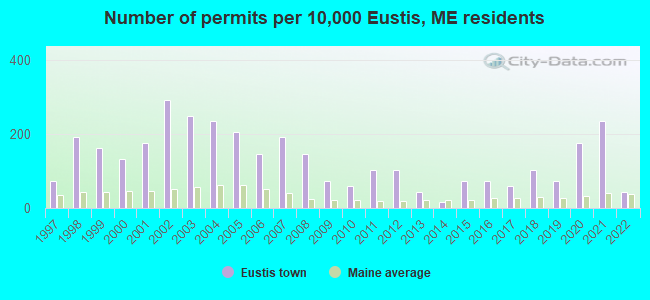
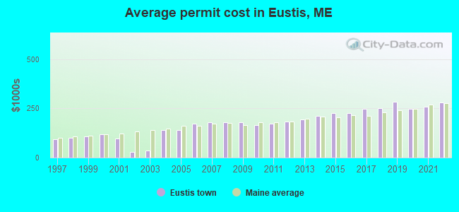
Single-family new house construction building permits:
- 2022: 3 buildings, average cost: $279,200
- 2021: 16 buildings, average cost: $259,200
- 2020: 12 buildings, average cost: $248,200
- 2019: 5 buildings, average cost: $282,200
- 2018: 7 buildings, average cost: $249,800
- 2017: 4 buildings, average cost: $248,100
- 2016: 5 buildings, average cost: $226,800
- 2015: 5 buildings, average cost: $226,800
- 2014: 1 building, cost: $211,200
- 2013: 3 buildings, average cost: $193,300
- 2012: 7 buildings, average cost: $184,000
- 2011: 7 buildings, average cost: $172,800
- 2010: 4 buildings, average cost: $165,900
- 2009: 5 buildings, average cost: $178,900
- 2008: 10 buildings, average cost: $181,200
- 2007: 13 buildings, average cost: $181,200
- 2006: 10 buildings, average cost: $171,000
- 2005: 14 buildings, average cost: $138,800
- 2004: 16 buildings, average cost: $138,800
- 2003: 17 buildings, average cost: $35,600
- 2002: 20 buildings, average cost: $30,000
- 2001: 12 buildings, average cost: $95,300
- 2000: 9 buildings, average cost: $118,000
- 1999: 11 buildings, average cost: $109,200
- 1998: 13 buildings, average cost: $101,700
- 1997: 5 buildings, average cost: $91,700
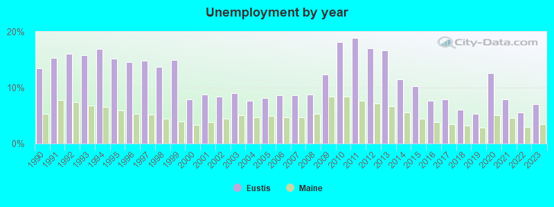
| Here: | 7.0% |
| Maine: | 3.4% |
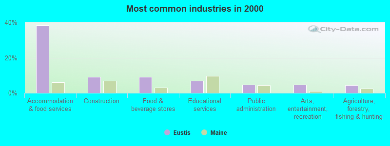
- Accommodation & food services (38.3%)
- Construction (9.1%)
- Food & beverage stores (9.1%)
- Educational services (6.8%)
- Public administration (4.7%)
- Arts, entertainment, recreation (4.7%)
- Agriculture, forestry, fishing & hunting (4.4%)
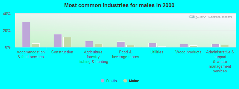
- Accommodation & food services (30.3%)
- Construction (15.7%)
- Agriculture, forestry, fishing & hunting (7.6%)
- Food & beverage stores (6.6%)
- Utilities (5.1%)
- Wood products (4.0%)
- Administrative & support & waste management services (4.0%)
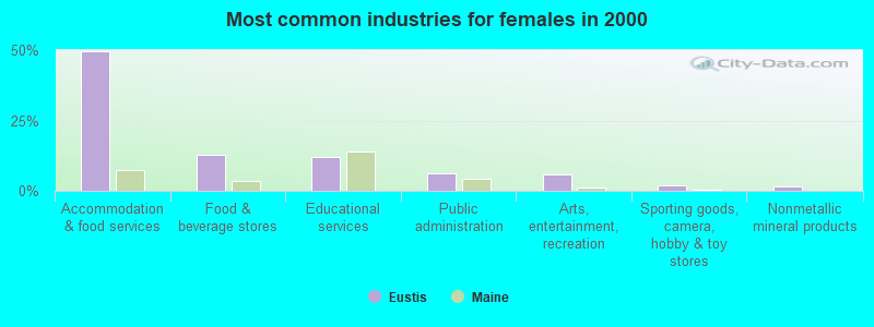
- Accommodation & food services (49.6%)
- Food & beverage stores (12.8%)
- Educational services (12.1%)
- Public administration (6.4%)
- Arts, entertainment, recreation (5.7%)
- Sporting goods, camera, hobby & toy stores (2.1%)
- Nonmetallic mineral products (1.4%)
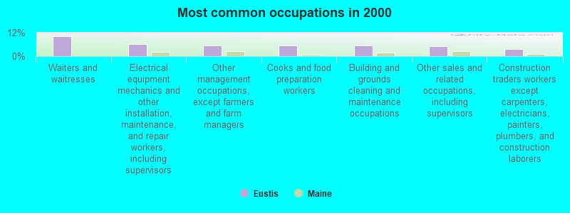
- Waiters and waitresses (10.3%)
- Electrical equipment mechanics and other installation, maintenance, and repair workers, including supervisors (6.2%)
- Other management occupations, except farmers and farm managers (5.6%)
- Cooks and food preparation workers (5.6%)
- Building and grounds cleaning and maintenance occupations (5.3%)
- Other sales and related occupations, including supervisors (5.0%)
- Construction traders workers except carpenters, electricians, painters, plumbers, and construction laborers (3.5%)
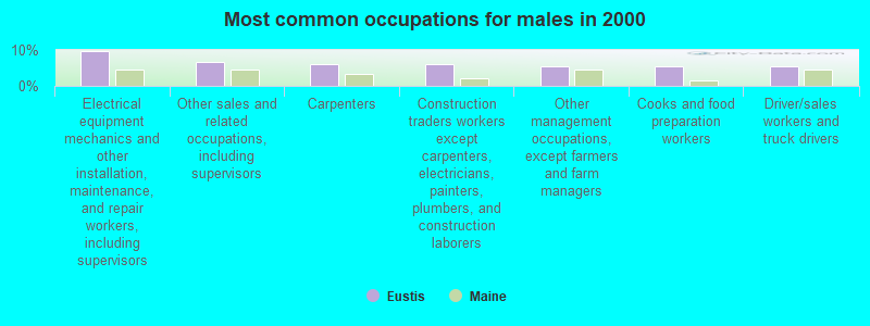
- Electrical equipment mechanics and other installation, maintenance, and repair workers, including supervisors (9.6%)
- Other sales and related occupations, including supervisors (6.6%)
- Carpenters (6.1%)
- Construction traders workers except carpenters, electricians, painters, plumbers, and construction laborers (6.1%)
- Other management occupations, except farmers and farm managers (5.6%)
- Cooks and food preparation workers (5.6%)
- Driver/sales workers and truck drivers (5.6%)
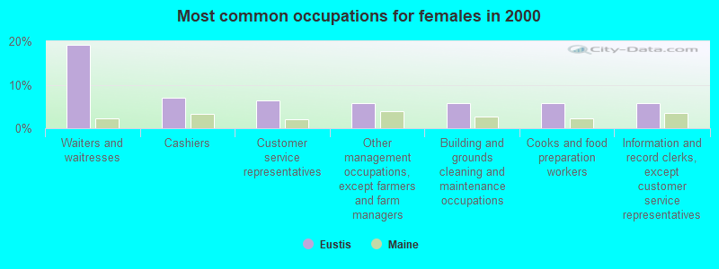
- Waiters and waitresses (19.1%)
- Cashiers (7.1%)
- Customer service representatives (6.4%)
- Other management occupations, except farmers and farm managers (5.7%)
- Building and grounds cleaning and maintenance occupations (5.7%)
- Cooks and food preparation workers (5.7%)
- Information and record clerks, except customer service representatives (5.7%)
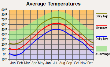
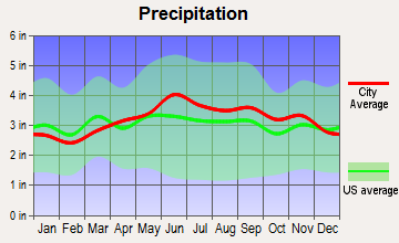
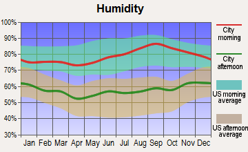
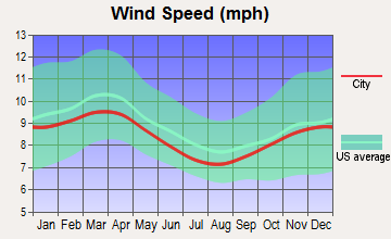
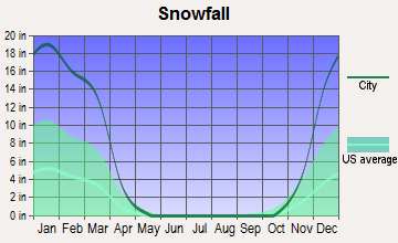
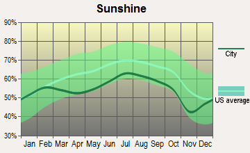
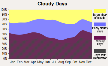
Average climate in Eustis, Maine
Based on data reported by over 4,000 weather stations
(lower is better)
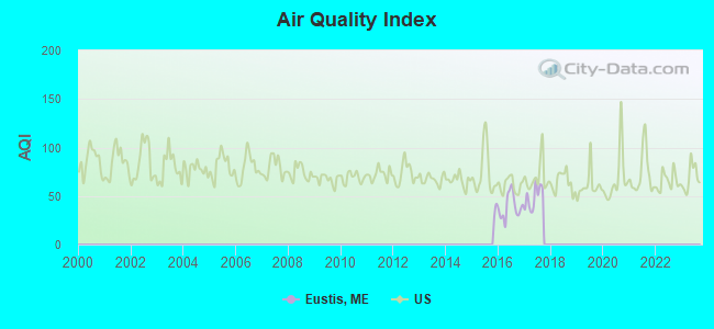
Air Quality Index (AQI) level in 2017 was 48.9. This is significantly better than average.
| City: | 48.9 |
| U.S.: | 72.6 |
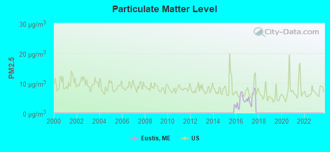
Particulate Matter (PM2.5) [µg/m3] level in 2017 was 5.24. This is significantly better than average. Closest monitor was 13.9 miles away from the city center.
| City: | 5.24 |
| U.S.: | 8.11 |
Earthquake activity:
Eustis-area historical earthquake activity is significantly above Maine state average. It is 79% smaller than the overall U.S. average.On 4/20/2002 at 10:50:47, a magnitude 5.3 (5.3 ML, Depth: 3.0 mi, Class: Moderate, Intensity: VI - VII) earthquake occurred 165.5 miles away from the city center
On 4/20/2002 at 10:50:47, a magnitude 5.2 (5.2 MB, 4.2 MS, 5.2 MW, 5.0 MW) earthquake occurred 167.0 miles away from the city center
On 10/7/1983 at 10:18:46, a magnitude 5.3 (5.1 MB, 5.3 LG, 5.1 ML) earthquake occurred 209.4 miles away from the city center
On 10/16/2012 at 23:12:25, a magnitude 4.7 (4.7 ML, Depth: 10.0 mi, Class: Light, Intensity: IV - V) earthquake occurred 110.0 miles away from Eustis center
On 1/19/1982 at 00:14:42, a magnitude 4.7 (4.5 MB, 4.7 MD, 4.5 LG) earthquake occurred 129.3 miles away from Eustis center
On 2/26/1999 at 03:38:43, a magnitude 3.8 (3.8 LG, Depth: 2.0 mi, Class: Light, Intensity: II - III) earthquake occurred 66.8 miles away from Eustis center
Magnitude types: regional Lg-wave magnitude (LG), body-wave magnitude (MB), duration magnitude (MD), local magnitude (ML), surface-wave magnitude (MS), moment magnitude (MW)
Natural disasters:
The number of natural disasters in Franklin County (27) is a lot greater than the US average (15).Major Disasters (Presidential) Declared: 19
Emergencies Declared: 7
Causes of natural disasters: Floods: 16, Storms: 14, Snows: 7, Heavy Rains: 2, Hurricanes: 2, Blizzard: 1, Ice Storm: 1, Landslide: 1, Snowfall: 1, Tropical Storm: 1, Wind: 1, Winter Storm: 1, Other: 2 (Note: some incidents may be assigned to more than one category).
Colleges/universities with over 2000 students nearest to Eustis:
- University of Maine at Farmington (about 39 miles; Farmington, ME; Full-time enrollment: 2,036)
- University of Maine at Augusta (about 67 miles; Augusta, ME; FT enrollment: 3,204)
- Husson University (about 86 miles; Bangor, ME; FT enrollment: 2,421)
- University of Maine (about 90 miles; Orono, ME; FT enrollment: 8,931)
- Saint Joseph's College of Maine (about 94 miles; Standish, ME; FT enrollment: 2,010)
- University of Southern Maine (about 106 miles; Portland, ME; FT enrollment: 6,647)
- Southern Maine Community College (about 107 miles; South Portland, ME; FT enrollment: 4,666)
Points of interest:
Notable locations in Eustis: Cathedral Pines Campground (A), Stratton Public Library (B), Dead River Historical Society (C), Eustis Fire Department (D). Display/hide their locations on the map
Church in Eustis: Flagstaff Memorial Church (A). Display/hide its location on the map
Cemeteries: Flagstaff Cemetery (1), Eustis Cemetery (2). Display/hide their locations on the map
Lakes and reservoirs: Wethern Pond (A), Barnard Pond (B), Little Barnard Pond (C), Reed Pond (D), North Branch Dead River Reservoir (E). Display/hide their locations on the map
Streams, rivers, and creeks: Barnard Brook (A), South Branch Dead River (B), Tim Brook (C), Trout Brook (D), Stratton Brook (E), Sawyer Brook (F), Tea Brook (G), Lutton Brook (H), Reed Brook (I). Display/hide their locations on the map
Drinking water stations with addresses in Eustis and their reported violations in the past:
TRAILS END STEAK HOUSE (Population served: 390, Groundwater):Past health violations:TIM POND WILDERNESS CAMPS (Population served: 44, Groundwater):Past monitoring violations:
- MCL, Monthly (TCR) - Between JAN-2009 and MAR-2009, Contaminant: Coliform. Follow-up actions: St Public Notif requested (APR-09-2009), St Formal NOV issued (APR-09-2009), St Public Notif received (MAY-08-2009), St Compliance achieved (MAY-12-2009)
- 4 routine major monitoring violations
Past monitoring violations:
- Monitoring, Repeat Major (TCR) - In MAY-2006, Contaminant: Coliform (TCR). Follow-up actions: St Public Notif requested (JUN-15-2006), St Violation/Reminder Notice (JUN-15-2006), St Public Notif received (2 times from SEP-12-2007 to SEP-12-2007), St Compliance achieved (SEP-27-2007)
- 2 routine major monitoring violations
Drinking water stations with addresses in Eustis that have no violations reported:
- CATHEDRAL PINES CAMPGROUND (Population served: 310, Primary Water Source Type: Groundwater under infl of surface water)
| This town: | 2.0 people |
| Maine: | 2.3 people |
| This town: | 57.2% |
| Whole state: | 62.9% |
| This town: | 8.3% |
| Whole state: | 9.4% |
Likely homosexual households (counted as self-reported same-sex unmarried-partner households)
- Lesbian couples: 0.6% of all households
- Gay men: 0.0% of all households
| This town: | 14.3% |
| Whole state: | 10.9% |
| This town: | 4.5% |
| Whole state: | 4.1% |
For population 15 years and over in Eustis:
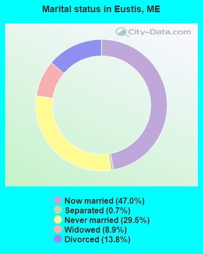
- Never married: 29.5%
- Now married: 47.0%
- Separated: 0.7%
- Widowed: 8.9%
- Divorced: 13.8%
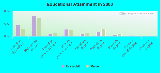
For population 25 years and over in Eustis:
- High school or higher: 77.8%
- Bachelor's degree or higher: 14.0%
- Graduate or professional degree: 5.7%
- Unemployed: 2.6%
- Mean travel time to work (commute): 17.5 minutes
| Here: | 10.5 |
| Maine average: | 11.2 |
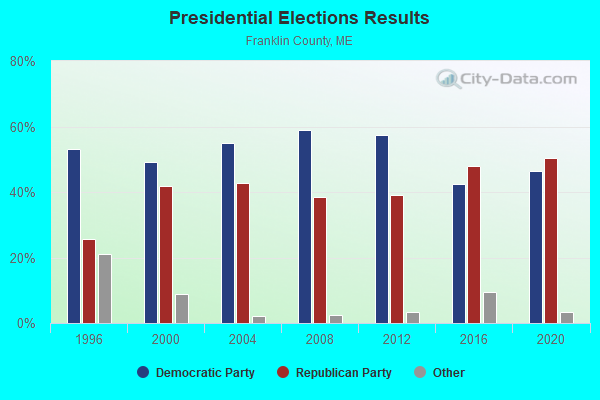
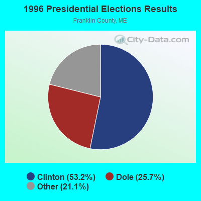
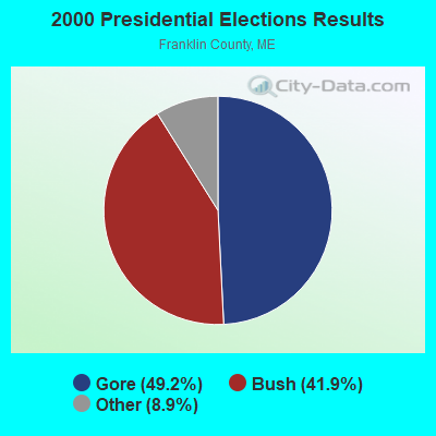

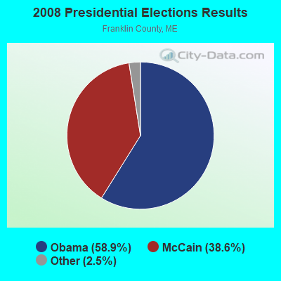
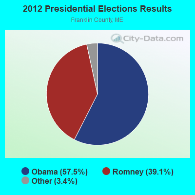


Graphs represent county-level data. Detailed 2008 Election Results
Religion statistics for Eustis, ME (based on Franklin County data)
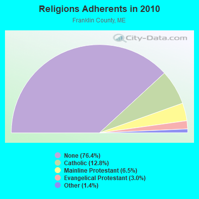
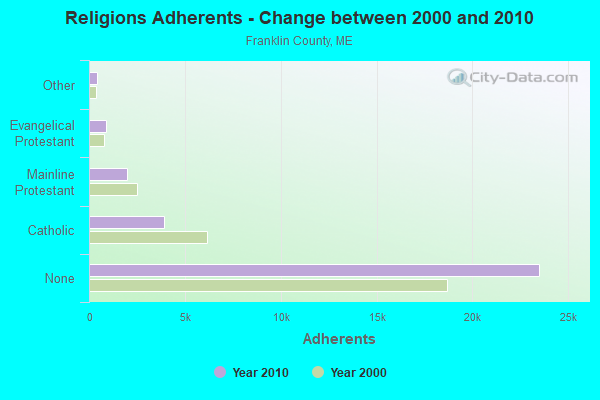
| Religion | Adherents | Congregations |
|---|---|---|
| Catholic | 3,936 | 5 |
| Mainline Protestant | 2,003 | 21 |
| Evangelical Protestant | 908 | 16 |
| Other | 427 | 2 |
| None | 23,494 | - |
Food Environment Statistics:
| Here: | 4.68 / 10,000 pop. |
| State: | 2.80 / 10,000 pop. |
| Franklin County: | 0.33 / 10,000 pop. |
| Maine: | 0.14 / 10,000 pop. |
| Here: | 3.01 / 10,000 pop. |
| State: | 2.20 / 10,000 pop. |
| Here: | 6.69 / 10,000 pop. |
| State: | 5.75 / 10,000 pop. |
| Franklin County: | 14.38 / 10,000 pop. |
| Maine: | 11.02 / 10,000 pop. |
| This county: | 7.3% |
| Maine: | 8.2% |
| Here: | 24.4% |
| Maine: | 25.0% |
Strongest AM radio stations in Eustis:
- WTME (780 AM; 10 kW; RUMFORD, ME; Owner: MOUNTAIN VALLEY BROADCASTING, INC.)
- WSKW (1160 AM; 10 kW; SKOWHEGAN, ME; Owner: MOUNTAIN WIRELESS, INCORPORATED)
- WCHP (760 AM; 35 kW; CHAMPLAIN, NY; Owner: CHAMPLAIN RADIO, INC.)
- WRKO (680 AM; 50 kW; BOSTON, MA; Owner: ENTERCOM BOSTON LICENSE, LLC)
- WEEI (850 AM; 50 kW; BOSTON, MA; Owner: ENTERCOM BOSTON LICENSE, LLC)
- WNNZ (640 AM; 50 kW; WESTFIELD, MA; Owner: CLEAR CHANNEL BROADCASTING LICENSES, INC.)
- WCRN (830 AM; 50 kW; WORCESTER, MA; Owner: CARTER BROADCASTING CORPORATION)
- WBZ (1030 AM; 50 kW; BOSTON, MA; Owner: INFINITY BROADCASTING OPERATIONS, INC.)
- WZON (620 AM; 5 kW; BANGOR, ME; Owner: THE ZONE CORPORATION)
- WGY (810 AM; 50 kW; SCHENECTADY, NY; Owner: CLEAR CHANNEL BROADCASTING LICENSES, INC.)
- WMTW (870 AM; 10 kW; GORHAM, ME; Owner: RADIO PARTNERS OF MAINE, L.P.)
- WICY (1490 AM; 50 kW; MALONE, NY; Owner: CARTIER COMMUNICATIONS INC.)
- WKOX (1200 AM; 50 kW; FRAMINGHAM, MA; Owner: CAPSTAR TX LIMITED PARTNERSHIP)
Strongest FM radio stations in Eustis:
- WTOS-FM (105.1 FM; SKOWHEGAN, ME; Owner: CAPSTAR TX LIMITED PARTNERSHIP)
- WPKQ (103.7 FM; NORTH CONWAY, NH; Owner: CITADEL BROADCASTING COMPANY)
- WHOM (94.9 FM; MT. WASHINGTON, NH; Owner: CITADEL BROADCASTING COMPANY)
- WLOB-FM (96.3 FM; RUMFORD, ME; Owner: ATLANTIC COAST RADIO, LLC)
- WTBM (100.7 FM; MEXICO, ME; Owner: MOUNTAIN VALLEY BROADCASTING, INC.)
- Eustis, Maine
- Fatal accident count8
- Vehicles involved in fatal accidents9
- Fatal accidents involving drunk persons:4
- Fatalities10
- Persons involved in fatal accidents13
- Pedestrians involved in fatal accidents1
- Maine average
- Fatal accident count1437
- Vehicles involved in fatal accidents2077
- Fatal accidents involving drunk persons493
- Fatalities1589
- Persons involved in fatal accidents3508
- Pedestrians involved in fatal accidents115
- National Bridge Inventory (NBI) Statistics
- 6Number of bridges
- 39ft / 11.8mTotal length
- 7,403Total average daily traffic
- 368Total average daily truck traffic
- 10,997Total future (year 2036) average daily traffic
FCC Registered Cell Phone Towers:
1- On Eustis Ridge, 2.9 Km Sw Of (Lat: 45.193111 Lon: -70.500056), Structure height: 27.4 m, Call Sign: KNKN699
Assigned Frequencies: 880.020 MHz, 891.510 MHz, 835.020 MHz, 846.510 MHzGrant Date: 09/01/2020, Expiration Date: 10/01/2030, Certifier: John T Scott IiiRegistrant: Verizon Wireless, 5055 North Point Pkwy, Np2ne Network Engineering, Alpharetta, GA 30022, Phone: (770) 797-1070, Fax: (770) 797-1036, Email:
FCC Registered Broadcast Land Mobile Towers:
4- Eustis Ridge (Lat: 45.192556 Lon: -70.497000), Call Sign: WSL744, Licensee ID: L00015362,
Assigned Frequencies: 159.330 MHz, 159.420 MHz, Grant Date: 07/27/2000, Expiration Date: 08/27/2005, Cancellation Date: 09/29/2003, Registrant: State Of Maine, Rr 1 Box 650, Augusta, ME 04330, Phone: (207) 246-3411
- Eustis Village (Lat: 45.214778 Lon: -70.493944), Call Sign: KGH302, Licensee ID: L00095272,
Assigned Frequencies: 158.460 MHz, Grant Date: 02/11/1997, Expiration Date: 03/25/2002, Cancellation Date: 05/26/2002, Registrant: Duluth Wing, Eustis Village Box 27, Eustis, ME 04936
- EUSTIS, Rt 27 Rest Area (Lat: 45.228500 Lon: -70.490500), Type: Pole, Structure height: 5 m, Overall height: 7 m, Call Sign: WPTP991,
Assigned Frequencies: 453.400 MHz, Grant Date: 09/04/2021, Expiration Date: 11/20/2031, Certifier: William Plante, Registrant: State Of Maine, O.I.T., Radio Operations, 66 Industrial Drive, Augusta, ME 04333-0147, Phone: (207) 624-9990, Email:
- Lat: 45.194611 Lon: -70.467750, Call Sign: WQOL917,
Assigned Frequencies: 49.1000 MHz, 44.1000 MHz, Grant Date: 11/05/2021, Expiration Date: 11/10/2031, Certifier: Shad Hall, Registrant: Shad\'s Custom Countertops, Inc., 11 Collins Pond Rd, Windham, ME 04062, Phone: (207) 893-3445, Email:
FCC Registered Paging Towers:
2- Eustis Ridge Road (Lat: 45.197806 Lon: -70.491722), Call Sign: KCK74, Licensee ID: L00002267,
Assigned Frequencies: 152.810 MHz, Expiration Date: 11/01/1998, Cancellation Date: 10/26/1999, Registrant: Somerset Telephone Company, 301 South Westfield Road, Madison, WI 53705
- Eustis Ridge Road (Lat: 45.197806 Lon: -70.491722), Call Sign: KCC486,
Assigned Frequencies: 152.630 MHz, Grant Date: 06/04/2019, Expiration Date: 04/01/2029, Registrant: Holland & Knight LLP, 2099 Pennsylvania Avenue, Nw, Suite 100, Washington, DC 20006-6801, Phone: (202) 955-3000, Fax: (202) 955-5564, Email:
FCC Registered Amateur Radio Licenses:
1- Call Sign: WA1SAZ, Licensee ID: L00147242, Grant Date: 02/02/2017, Expiration Date: 04/30/2027, Certifier: Nathan D Marvin, Registrant: Nathan D Marvin, 15 Woodcock Ln, Eustis, ME 04936
FAA Registered Aircraft:
1- Aircraft: CESSNA 180D (Category: Land, Seats: 4, Weight: Up to 12,499 Pounds, Speed: 121 mph), Engine: CONT MOTOR O-470 SERIES (230 HP) (Reciprocating)
N-Number: 8607X, N8607X, N-8607X, Serial Number: 18051007, Year manufactured: 1960, Airworthiness Date: 02/03/1961, Certificate Issue Date: 01/14/2005
Registrant (Individual): Richard R Wilkinson, 89 Perry Rd / Po Box 88, Eustis, ME 04936
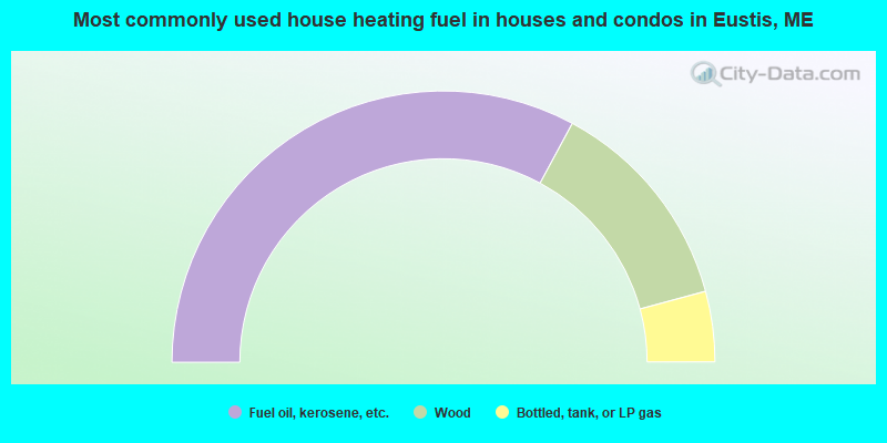
- 65.7%Fuel oil, kerosene, etc.
- 25.8%Wood
- 8.4%Bottled, tank, or LP gas
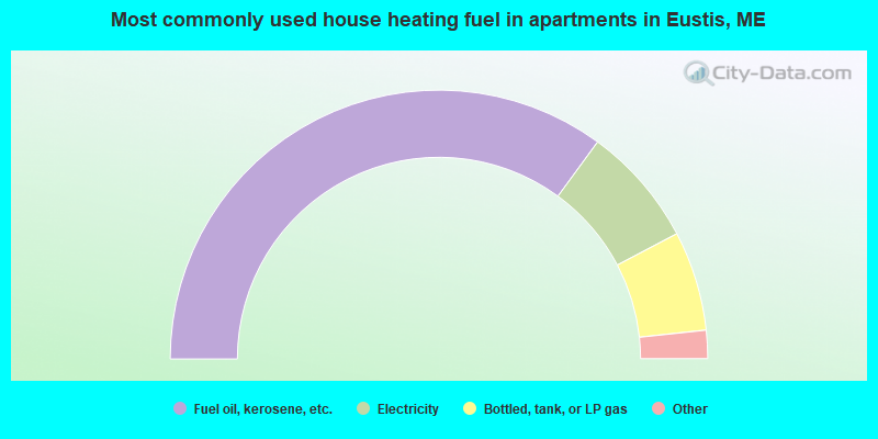
- 70.1%Fuel oil, kerosene, etc.
- 14.5%Electricity
- 12.0%Bottled, tank, or LP gas
- 1.7%Utility gas
- 1.7%Wood
Eustis compared to Maine state average:
- Unemployed percentage significantly below state average.
- Black race population percentage significantly below state average.
- Hispanic race population percentage significantly below state average.
- Median age above state average.
- Length of stay since moving in significantly above state average.
- Number of rooms per house significantly below state average.
- House age significantly below state average.
- Number of college students below state average.
- Percentage of population with a bachelor's degree or higher below state average.
Eustis on our top lists:
- #46 on the list of "Top 100 cities with strongest arts, entertainment, recreation, accommodation and food services industries"

|
Total of 2 patent applications in 2008-2024.