Fosters, Alabama
Submit your own pictures of this place and show them to the world
- OSM Map
- General Map
- Google Map
- MSN Map

| Males: 1,319 | |
| Females: 1,387 |
| Median resident age: | 37.9 years |
| Alabama median age: | 35.8 years |
Zip code: 35463
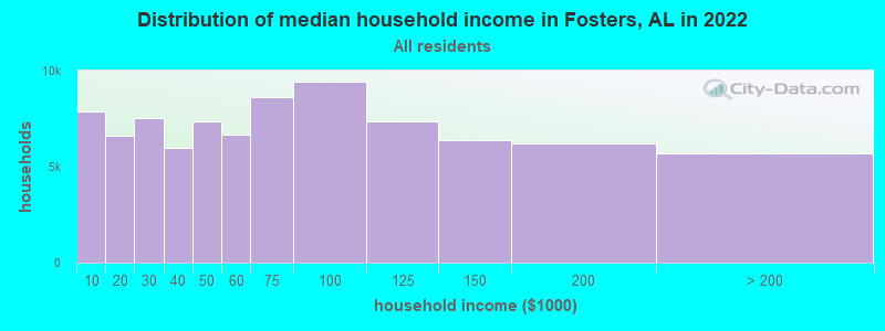
| Fosters: | $58,670 |
| AL: | $59,674 |
Estimated per capita income in 2022: $26,895 (it was $15,348 in 2000)
Fosters CCD income, earnings, and wages data
Estimated median house or condo value in 2022: $177,514 (it was $66,100 in 2000)
| Fosters: | $177,514 |
| AL: | $200,900 |
Mean prices in 2022: all housing units: $274,542; detached houses: $302,362; townhouses or other attached units: $210,995; in 2-unit structures: $86,470; in 3-to-4-unit structures: $67,951; in 5-or-more-unit structures: $151,988; mobile homes: $75,047; occupied boats, rvs, vans, etc.: $32,477
Detailed information about poverty and poor residents in Fosters, AL


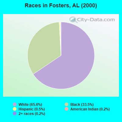
- 1,63965.6%White alone
- 83633.5%Black alone
- 130.5%Hispanic
- 60.2%American Indian alone
- 40.2%Two or more races
According to our research of Alabama and other state lists, there were 12 registered sex offenders living in Fosters, Alabama as of April 17, 2024.
The ratio of all residents to sex offenders in Fosters is 226 to 1.
 Recent articles from our blog. Our writers, many of them Ph.D. graduates or candidates, create easy-to-read articles on a wide variety of topics.
Current Local Time: CST time zone
Elevation: 150 feet
Land area: 105.2 square miles.
Population density: 26 people per square mile (very low).

| Fosters CCD: | 0.4% ($266) |
| Alabama: | 0.4% ($289) |
Nearest city with pop. 50,000+: Tuscaloosa, AL  (14.0 miles , pop. 77,906).
Nearest city with pop. 200,000+: Birmingham, AL (60.9 miles , pop. 242,820).
Nearest city with pop. 1,000,000+: Houston, TX (506.8 miles , pop. 1,953,631).
Nearest cities:
), ), ), ), ), ), Latitude: 33.08 N, Longitude: 87.72 W
Area code commonly used in this area: 205

| Here: | 2.3% |
| Alabama: | 2.6% |
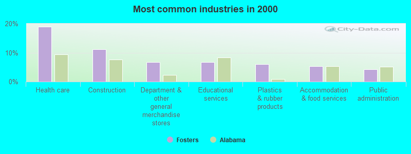
- Health care (19.0%)
- Construction (11.1%)
- Department & other general merchandise stores (6.8%)
- Educational services (6.8%)
- Plastics & rubber products (5.9%)
- Accommodation & food services (5.3%)
- Public administration (4.3%)
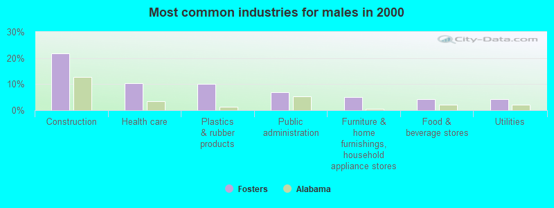
- Construction (21.8%)
- Health care (10.3%)
- Plastics & rubber products (10.2%)
- Public administration (7.0%)
- Furniture & home furnishings, household appliance stores (5.0%)
- Food & beverage stores (4.2%)
- Utilities (4.2%)
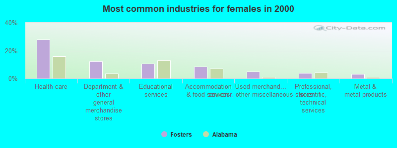
- Health care (28.0%)
- Department & other general merchandise stores (12.5%)
- Educational services (10.6%)
- Accommodation & food services (8.7%)
- Used merchandise, gift, novelty, souvenir, other miscellaneous stores (4.8%)
- Professional, scientific, technical services (3.8%)
- Metal & metal products (3.3%)
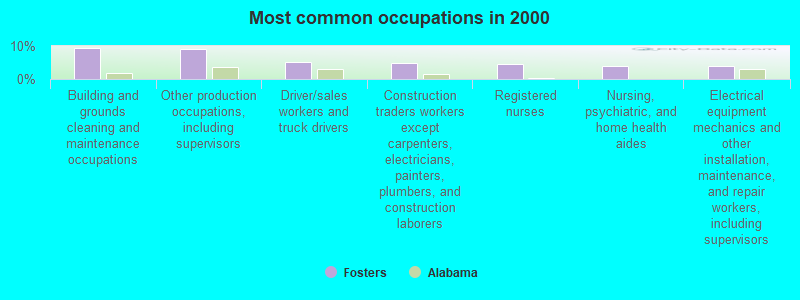
- Building and grounds cleaning and maintenance occupations (9.5%)
- Other production occupations, including supervisors (9.0%)
- Driver/sales workers and truck drivers (5.1%)
- Construction traders workers except carpenters, electricians, painters, plumbers, and construction laborers (4.8%)
- Registered nurses (4.4%)
- Nursing, psychiatric, and home health aides (3.9%)
- Electrical equipment mechanics and other installation, maintenance, and repair workers, including supervisors (3.9%)
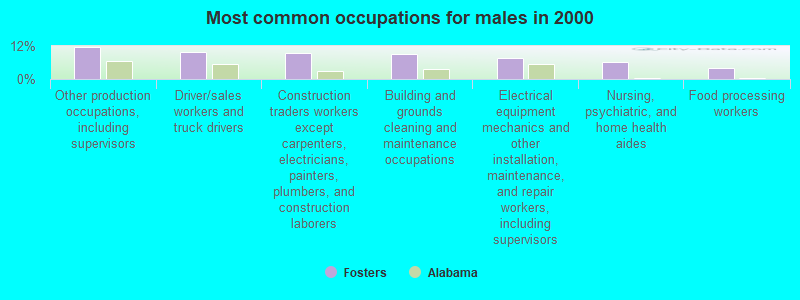
- Other production occupations, including supervisors (11.5%)
- Driver/sales workers and truck drivers (10.0%)
- Construction traders workers except carpenters, electricians, painters, plumbers, and construction laborers (9.5%)
- Building and grounds cleaning and maintenance occupations (9.0%)
- Electrical equipment mechanics and other installation, maintenance, and repair workers, including supervisors (7.7%)
- Nursing, psychiatric, and home health aides (6.2%)
- Food processing workers (4.2%)
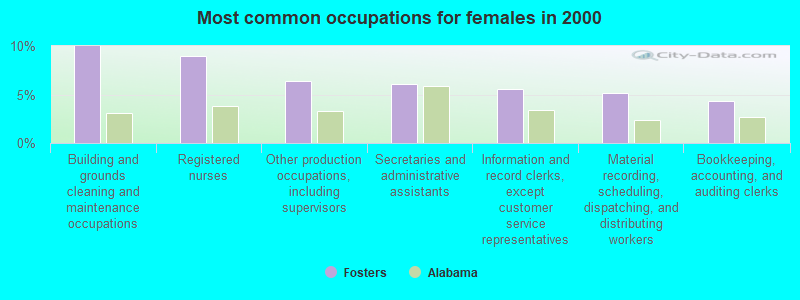
- Building and grounds cleaning and maintenance occupations (10.0%)
- Registered nurses (9.0%)
- Other production occupations, including supervisors (6.4%)
- Secretaries and administrative assistants (6.1%)
- Information and record clerks, except customer service representatives (5.5%)
- Material recording, scheduling, dispatching, and distributing workers (5.2%)
- Bookkeeping, accounting, and auditing clerks (4.3%)
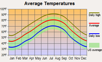
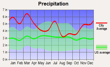
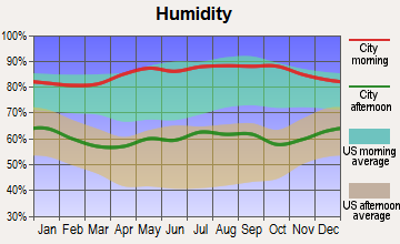
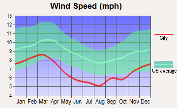
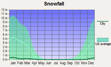
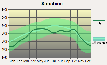
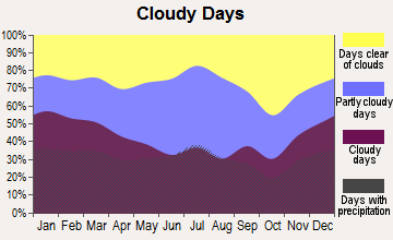
Average climate in Fosters, Alabama
Based on data reported by over 4,000 weather stations
(lower is better)
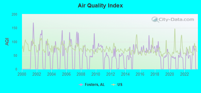
Air Quality Index (AQI) level in 2022 was 53.7. This is better than average.
| City: | 53.7 |
| U.S.: | 72.6 |
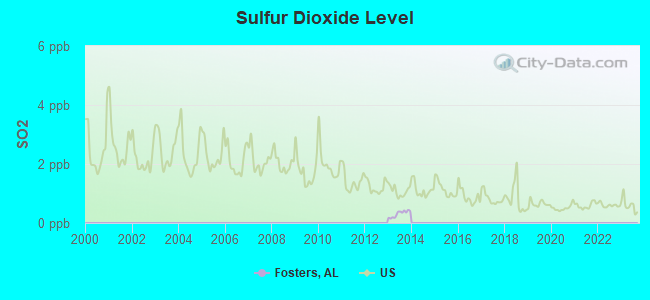
Sulfur Dioxide (SO2) [ppb] level in 2013 was 0.310. This is significantly better than average. Closest monitor was 14.2 miles away from the city center.
| City: | 0.310 |
| U.S.: | 1.515 |
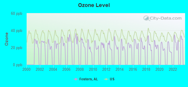
Ozone [ppb] level in 2022 was 26.2. This is better than average. Closest monitor was 14.0 miles away from the city center.
| City: | 26.2 |
| U.S.: | 33.3 |
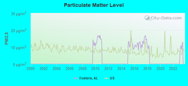
Particulate Matter (PM2.5) [µg/m3] level in 2017 was 13.2. This is significantly worse than average. Closest monitor was 14.0 miles away from the city center.
| City: | 13.2 |
| U.S.: | 8.1 |
Tornado activity:
Fosters-area historical tornado activity is near Alabama state average. It is 93% greater than the overall U.S. average.
On 12/16/2000, a category F4 (max. wind speeds 207-260 mph) tornado 2.5 miles away from the Fosters place center killed 11 people and injured 144 people and caused $12 million in damages.
On 3/3/1966, a category F5 (max. wind speeds 261-318 mph) tornado 26.6 miles away from the place center killed 58 people and injured 518 people and caused between $5,000,000 and $50,000,000 in damages.
Earthquake activity:
Fosters-area historical earthquake activity is significantly above Alabama state average. It is 147% greater than the overall U.S. average.On 1/18/1999 at 07:00:53, a magnitude 4.8 (4.8 MB, 4.0 LG, Depth: 0.6 mi, Class: Light, Intensity: IV - V) earthquake occurred 35.2 miles away from Fosters center
On 6/24/1975 at 11:11:36, a magnitude 4.5 (4.5 MB) earthquake occurred 44.7 miles away from the city center
On 10/24/1997 at 08:35:17, a magnitude 4.9 (4.8 MB, 4.2 MS, 4.9 LG, Depth: 6.2 mi) earthquake occurred 138.0 miles away from Fosters center
On 4/29/2003 at 08:59:39, a magnitude 4.9 (4.4 MB, 4.6 MW, 4.9 LG) earthquake occurred 155.1 miles away from the city center
On 11/7/2004 at 11:20:21, a magnitude 4.3 (4.3 MW, Depth: 3.1 mi) earthquake occurred 32.2 miles away from Fosters center
On 3/25/1976 at 00:41:20, a magnitude 5.0 (4.9 MB, 5.0 LG, Class: Moderate, Intensity: VI - VII) earthquake occurred 231.0 miles away from the city center
Magnitude types: regional Lg-wave magnitude (LG), body-wave magnitude (MB), surface-wave magnitude (MS), moment magnitude (MW)
Natural disasters:
The number of natural disasters in Tuscaloosa County (23) is greater than the US average (15).Major Disasters (Presidential) Declared: 16
Emergencies Declared: 5
Causes of natural disasters: Storms: 12, Floods: 10, Tornadoes: 10, Hurricanes: 5, Winds: 4, Drought: 1, Snowfall: 1, Winter Storm: 1, Other: 1 (Note: some incidents may be assigned to more than one category).
Hospitals and medical centers near Fosters:
- TUSCALOOSA DIALYSIS (Dialysis Facility, about 13 miles away; TUSCALOOSA, AL)
- HUNTER CREEK HEALTH AND REHABILITATION, LLC (Nursing Home, about 13 miles away; NORTHPORT, AL)
- DCH HOME HEALTH CARE AGENCY (Home Health Center, about 13 miles away; TUSCALOOSA, AL)
- NORTHPORT DIALYSIS (Dialysis Facility, about 14 miles away; NORTHPORT, AL)
- TUSCALOOSA UNIVERSITY DIALYSIS (Dialysis Facility, about 14 miles away; TUSCALOOSA, AL)
- FOREST MANOR INC (Nursing Home, about 14 miles away; NORTHPORT, AL)
- GLEN HAVEN HEALTH AND REHABILITATION, LLC (Nursing Home, about 14 miles away; NORTHPORT, AL)
Colleges/universities with over 2000 students nearest to Fosters:
- Shelton State Community College (about 10 miles; Tuscaloosa, AL; Full-time enrollment: 4,106)
- The University of Alabama (about 14 miles; Tuscaloosa, AL; FT enrollment: 30,931)
- University of West Alabama (about 44 miles; Livingston, AL; FT enrollment: 3,394)
- East Mississippi Community College (about 48 miles; Scooba, MS; FT enrollment: 5,180)
- Mississippi University for Women (about 50 miles; Columbus, MS; FT enrollment: 2,565)
- University of Montevallo (about 50 miles; Montevallo, AL; FT enrollment: 2,826)
- Lawson State Community College-Birmingham Campus (about 55 miles; Birmingham, AL; FT enrollment: 2,695)
Public elementary/middle school in Fosters:
- MYRTLEWOOD ELEM SCH (Students: 269, Location: 14701 GAINSVILLE RD, Grades: KG-5)
Points of interest:
Notable locations in Fosters: Willifords Landing (A), R H Fosters Landing (B), Manleys Landing (C), Hiphill Landing (D), Burroughs Landing (E), Foster Landing (F), Romulus Volunteer Fire Department (G), Fosters - Ralph Volunteer Fire Department Fosters Station (H), Fosters - Ralph Volunteer Fire Department Ralph Station (I). Display/hide their locations on the map
Churches in Fosters include: Mount Herman Church (A), New Hope Baptist Church (B), Mount Zion African Methodist Episcopal Zion Church (C), Bethel Baptist Church (D), Dry Creek Church (E), Victorious Life Church (F), Wesley Chapel United Methodist Church (G), Mount Zion Baptist Church (H), Mount Carmel Methodist Church (I). Display/hide their locations on the map
Cemeteries: Old Bethel Cemetery (1), Parham Ridge Cemetery (2), Robertson Cemetery (3), Mount Zion Cemetery (4), Mount Herman Cemetery (5), Jones-Townsend Cemetery (6), Grants Creek Cemetery (7). Display/hide their locations on the map
Lakes, reservoirs, and swamps: Snag Lake (A), Cypress Pond (B), Big Lake (C), Moon Lake (D), Lake Gloria (E), Reed Swamp (F). Display/hide their locations on the map
Streams, rivers, and creeks: Thornton Creek (A), Slaughter Creek (B), McCracken Creek (C), Little Branch (D), Grant Creek (E), Dry Creek (F), Arthur Creek (G), Woods Creek (H). Display/hide their locations on the map
| This place: | 2.5 people |
| Alabama: | 2.5 people |
| This place: | 74.9% |
| Whole state: | 67.8% |
| This place: | 4.2% |
| Whole state: | 4.7% |
Likely homosexual households (counted as self-reported same-sex unmarried-partner households)
- Lesbian couples: 0.9% of all households
- Gay men: 0.3% of all households
| This place: | 14.3% |
| Whole state: | 16.1% |
| This place: | 6.7% |
| Whole state: | 7.3% |
For population 15 years and over in Fosters:
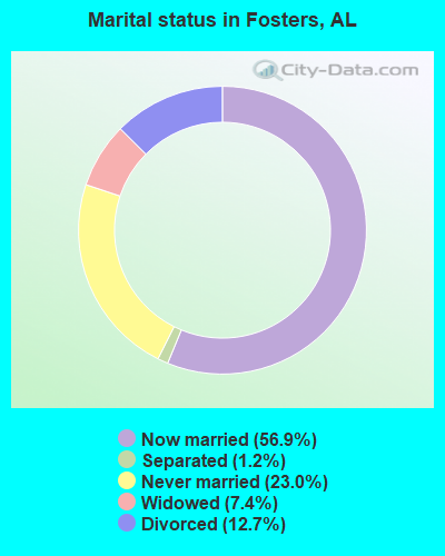
- Never married: 23.0%
- Now married: 56.9%
- Separated: 1.2%
- Widowed: 7.4%
- Divorced: 12.7%
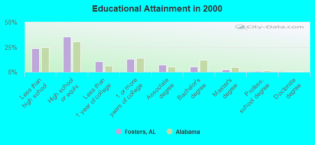
For population 25 years and over in Fosters:
- High school or higher: 76.1%
- Bachelor's degree or higher: 9.1%
- Graduate or professional degree: 3.9%
- Unemployed: 7.5%
- Mean travel time to work (commute): 28.4 minutes
| Here: | 11.6 |
| Alabama average: | 13.2 |
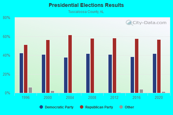
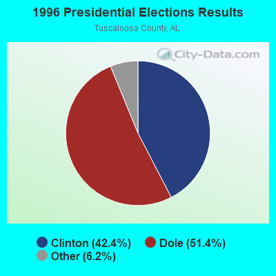
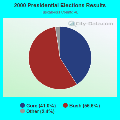
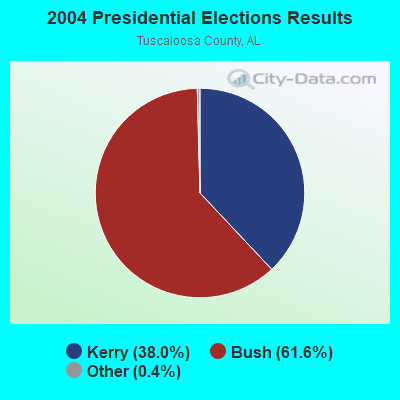
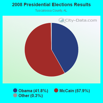
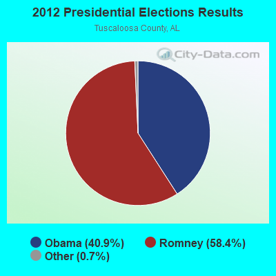
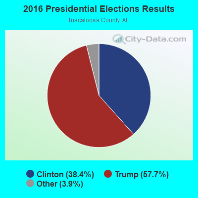
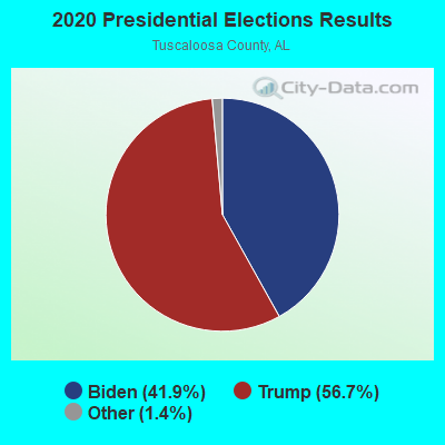
Graphs represent county-level data. Detailed 2008 Election Results
Religion statistics for Fosters, AL (based on Tuscaloosa County data)
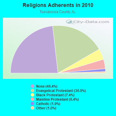
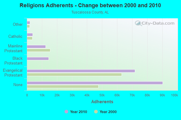
| Religion | Adherents | Congregations |
|---|---|---|
| Evangelical Protestant | 71,803 | 208 |
| Black Protestant | 14,428 | 45 |
| Mainline Protestant | 12,415 | 47 |
| Catholic | 3,729 | 2 |
| Other | 1,940 | 9 |
| None | 90,341 | - |
Food Environment Statistics:
| Tuscaloosa County: | 2.03 / 10,000 pop. |
| Alabama: | 1.89 / 10,000 pop. |
| This county: | 0.23 / 10,000 pop. |
| State: | 0.20 / 10,000 pop. |
| Tuscaloosa County: | 0.56 / 10,000 pop. |
| Alabama: | 0.65 / 10,000 pop. |
| This county: | 5.70 / 10,000 pop. |
| Alabama: | 6.32 / 10,000 pop. |
| Tuscaloosa County: | 5.47 / 10,000 pop. |
| Alabama: | 5.75 / 10,000 pop. |
| Tuscaloosa County: | 10.7% |
| Alabama: | 11.8% |
| Here: | 32.2% |
| State: | 31.7% |
| This county: | 10.8% |
| Alabama: | 13.5% |
Businesses in Fosters, AL
- Subway: 1
Strongest AM radio stations in Fosters:
- WTSK (790 AM; 5 kW; TUSCALOOSA, AL; Owner: APEX BROADCASTING INC.)
- WACT (1420 AM; 5 kW; TUSCALOOSA, AL; Owner: CAPSTAR TX LIMITED PARTNERSHIP)
- WJOX (690 AM; 50 kW; BIRMINGHAM, AL; Owner: CITADEL BROADCASTING COMPANY)
- WSPZ (1150 AM; 5 kW; TUSCALOOSA, AL; Owner: RADIO SOUTH, INC)
- WWPG (1280 AM; 5 kW; TUSCALOOSA, AL; Owner: LAWSON OF TUSCALOOSA, INC.)
- WAPI (1070 AM; 50 kW; BIRMINGHAM, AL; Owner: CITADEL BROADCASTING COMPANY)
- WDJC (850 AM; 50 kW; BIRMINGHAM, AL; Owner: KIMTRON, INC.)
- WCPC (940 AM; 50 kW; HOUSTON, MS; Owner: WCPC BROADCASTING CO., INC.)
- WNSI (810 AM; 50 kW; JACKSONVILLE, AL; Owner: UNITED BROADCASTING NETWORK, INC.)
- WTBC (1230 AM; 1 kW; TUSCALOOSA, AL; Owner: JOHN SISTY ENTERPRISES, INC.)
- WSJC (810 AM; 50 kW; MAGEE, MS; Owner: FAMILY TALK RADIO)
- WRAG (590 AM; 1 kW; CARROLLTON, AL; Owner: BIRMINGHAM CHRISTIAN RADIO)
- WYLS (670 AM; daytime; 5 kW; YORK, AL; Owner: GRANTELL BROADCASTING COMPANY)
Strongest FM radio stations in Fosters:
- WTUG-FM (92.9 FM; TUSCALOOSA, AL; Owner: APEX BROADCASTING INC.)
- WQZZ (104.3 FM; EUTAW, AL; Owner: JIM LAWSON COMMUNICATIONS, INC.)
- WBHJ (95.7 FM; TUSCALOOSA, AL; Owner: CXR HOLDINGS, INC.)
- WTXT (98.1 FM; FAYETTE, AL; Owner: CAPSTAR TX LIMITED PARTNERSHIP)
- WDXB (102.5 FM; JASPER, AL; Owner: CAPSTAR TX LIMITED PARTNERSHIP)
- WDGM (99.1 FM; GREENSBORO, AL; Owner: WARRIOR BROADCASTING INC.)
- WZBQ (94.1 FM; CARROLLTON, AL; Owner: CAPSTAR TX LIMITED PARTNERSHIP)
- WBEI (101.7 FM; REFORM, AL; Owner: APEX BROADCASTING INC.)
- WANZ (100.7 FM; NORTHPORT, AL; Owner: APEX BRAODCASTING INC.)
- WUAL-FM (91.5 FM; TUSCALOOSA, AL; Owner: UNIVERSITY OF ALABAMA)
- WALN (89.3 FM; CARROLLTON, AL; Owner: AMERICAN FAMILY ASSOCIATION)
- W247AN (97.3 FM; TUSCALOOSA, AL; Owner: WILLIAM PAXTON ROGERS)
- WRTR (105.5 FM; TUSCALOOSA, AL; Owner: CAPSTAR TX LIMITED PARTNERSHIP)
- WVUA-FM (90.7 FM; TUSCALOOSA, AL; Owner: BD OF TRUSTEES, THE UNIVERSITY OF AL)
- W213AS (90.5 FM; CARROLLTON, AL; Owner: WEST ALABAMA CHRISTIAN COMMS., INC.)
TV broadcast stations around Fosters:
- WLDM (Channel 23; TUSCALOOSA, AL; Owner: CHANNEL 23, LLC)
- W46BU (Channel 46; TUSCALOOSA, AL; Owner: TRINITY BROADCASTING NETWORK)
- WCFT-TV (Channel 33; TUSCALOOSA, AL; Owner: TV ALABAMA, INCORPORATED)
- WVUA-CA (Channel 7; TUSCALOOSA/NORTHPORT, AL; Owner: THE BOARD OF TRUSTEES OF THE UNIVERSITY OF ALABAMA)
- WDBB (Channel 17; BESSEMER, AL; Owner: WDBB-TV, INC.)
- WDVZ-CA (Channel 3; GREENSBORO, AL; Owner: TTI, INC.)
- WJMY-CA (Channel 28; DEMOPOLIS, AL; Owner: TTI, INC.)
FCC Registered Cell Phone Towers:
2 (See the full list of FCC Registered Cell Phone Towers in Fosters)FCC Registered Antenna Towers:
33 (See the full list of FCC Registered Antenna Towers)FCC Registered Broadcast Land Mobile Towers:
2- HWY 11 TANKS, 14397 Water Tower Road (Lat: 33.066000 Lon: -87.728667), Type: Pipe, Structure height: 6 m, Call Sign: WQAC695,
Assigned Frequencies: 465.187 MHz, Grant Date: 03/07/2014, Expiration Date: 05/05/2024, Certifier: Bobby Beck, Registrant: Duke Instrument Service, Saraland, AL 36571-0189, Phone: (251) 675-6067, Fax: (251) 675-5938, Email:
- HWY 11 TANKS, 14397 Water Tower Road (Lat: 33.066000 Lon: -87.728667), Type: Pipe, Structure height: 6 m, Call Sign: WQFN482,
Assigned Frequencies: 460.187 MHz, Grant Date: 06/03/2016, Expiration Date: 08/23/2026, Certifier: Bobby Beck, Registrant: Allcomm Wireless, 4116 First Avenue North, Birmingham, AL 35222, Phone: (205) 271-4006, Fax: (205) 595-7642
FCC Registered Microwave Towers:
4- SYLVAN CHURC, 15398 Sylvan Loop Road (Lat: 33.065833 Lon: -87.699389), Type: Gtower, Structure height: 76.2 m, Overall height: 80.8 m, Call Sign: WQOY762,
Assigned Frequencies: 6197.24 MHz, 6226.89 MHz, 6256.54 MHz, 6286.19 MHz, Grant Date: 02/01/2022, Expiration Date: 03/07/2032, Certifier: John E Monday, Registrant: At&t Services, Inc., 208 S Akard St, 20f, Dallas, TX 75202, Phone: (855) 699-7073, Email:
- FOSTERS, Off Sand Road (Lat: 33.108000 Lon: -87.700528), Type: Gtower, Structure height: 121.9 m, Overall height: 129.5 m, Call Sign: WQWM760,
Assigned Frequencies: 11095.0 MHz, 11135.0 MHz, 11095.0 MHz, 11135.0 MHz, 11095.0 MHz, 11135.0 MHz, 11095.0 MHz, 11135.0 MHz, 11095.0 MHz, 11135.0 MHz... (+6 more), Grant Date: 10/06/2015, Expiration Date: 10/06/2025, Certifier: Larry F Butts, Registrant: Southern Company Services, 600 N. 18th St / Bin 5n-5409, Birmingham, AL 35203, Phone: (205) 257-7600, Fax: (205) 257-2134, Email:
- FOSTERS MASTER, Off Sand Road (Lat: 33.108000 Lon: -87.700528), Type: Gtower, Structure height: 121.9 m, Overall height: 129.5 m, Call Sign: WQWZ709,
Assigned Frequencies: 928.143 MHz, 952.143 MHz, Grant Date: 01/08/2016, Expiration Date: 01/08/2026, Cancellation Date: 02/27/2019, Certifier: Larry Butts, Registrant: Southern Company, 600 N. 18th Street/5n-8409, Birmingham, AL 35203, Phone: (205) 257-3223, Fax: (205) 257-2134, Email:
- TUSCALOOSA S, .25 Mi W Of Us 11/45, 1 Mi N Of Fosters (Lat: 33.108444 Lon: -87.682778), Overall height: 90.8 m, Call Sign: WLS497,
Assigned Frequencies: 2168.40 MHz, Grant Date: 12/19/2000, Expiration Date: 02/01/2011, Cancellation Date: 01/17/2007, Registrant: Verizon Wireless, 1120 Sanctuary Pkwy, #150, Gasa5reg, Alpharetta, GA 30004, Phone: (770) 797-1070, Fax: (770) 797-1036, Email:
FCC Registered Amateur Radio Licenses:
3- Call Sign: KC4IZS, Grant Date: 10/16/1998, Expiration Date: 10/16/2008, Cancellation Date: 10/19/2010, Registrant: Ken W Lewis, 15282 Sylvan Loop Rd, Fosters, AL 35463-9619
- Call Sign: KG4BQL, Grant Date: 01/21/1999, Expiration Date: 01/21/2009, Cancellation Date: 01/22/2011, Registrant: Christine T Gladney, 13207 Fosters Loop Rd, Fosters, AL 35463
- Call Sign: KK4FMF, Licensee ID: L01675141, Grant Date: 11/29/2011, Expiration Date: 11/29/2021, Cancellation Date: 11/30/2023, Certifier: Matt Harless, Registrant: Matt Harless, 14783 Harless Hill Dr, Fosters, AL 35463-9693
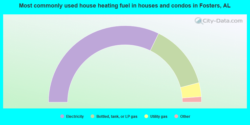
- 64.5%Electricity
- 27.3%Bottled, tank, or LP gas
- 5.9%Utility gas
- 1.5%Fuel oil, kerosene, etc.
- 0.8%Wood
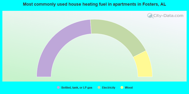
- 47.7%Bottled, tank, or LP gas
- 37.2%Electricity
- 15.1%Wood
Fosters compared to Alabama state average:
- Unemployed percentage below state average.
- Hispanic race population percentage significantly below state average.
- Median age below state average.
- Foreign-born population percentage significantly below state average.
- Renting percentage significantly below state average.
- Length of stay since moving in significantly above state average.
- Number of rooms per house significantly below state average.
- House age significantly below state average.
- Number of college students below state average.
- Percentage of population with a bachelor's degree or higher below state average.