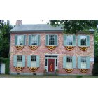
Funkstown, Maryland
Submit your own pictures of this town and show them to the world
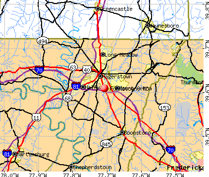
- OSM Map
- General Map
- Google Map
- MSN Map
Population change since 2000: -13.6%
 |
| Males: 422 | |
| Females: 427 |
| Median resident age: | 60.0 years |
| Maryland median age: | 39.7 years |
Zip codes: 21734.
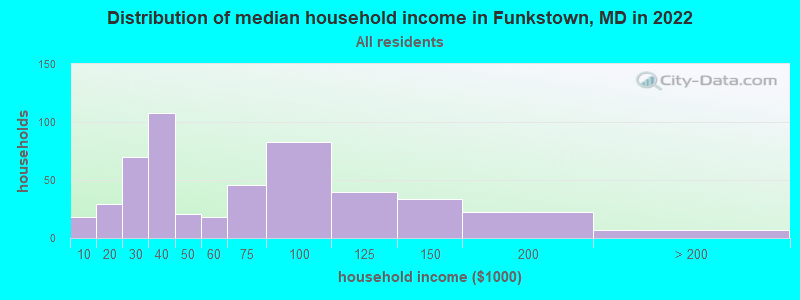
| Funkstown: | $50,066 |
| MD: | $94,991 |
Estimated per capita income in 2022: $35,805 (it was $17,544 in 2000)
Funkstown town income, earnings, and wages data
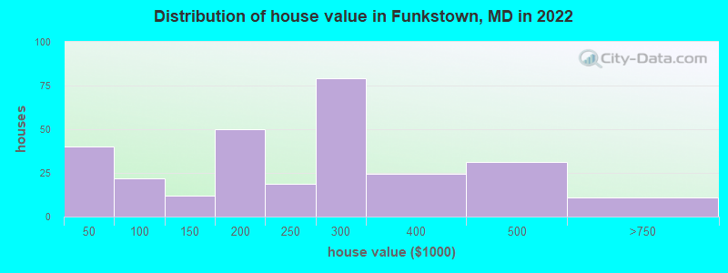
Estimated median house or condo value in 2022: $251,068 (it was $90,300 in 2000)
| Funkstown: | $251,068 |
| MD: | $398,100 |
Mean prices in 2022: all housing units: $240,626; detached houses: $279,373; townhouses or other attached units: $155,087; mobile homes: $34,296
Median gross rent in 2022: $667.
Detailed information about poverty and poor residents in Funkstown, MD
Compare current foreclosures near Funkstown, MD:
| Photo | Address | Area | Beds / Baths | Price | Details |
|---|---|---|---|---|---|

|
#1
Oriole Cir
Hagerstown, MD 21742
|
1,724 sq. feet
|
2 baths 3 beds |
$329,900
|
show details |

|
#2
Spielman Rd
Williamsport, MD 21795
|
1,758 sq. feet
|
1 baths 3 beds |
$165,000
|
show details |

|
#3
Military Rd
Cascade, MD 21719
|
2,496 sq. feet
|
3 baths 4 beds |
$369,500
|
show details |

|
#4
Shale Dr
Hagerstown, MD 21740
|
3,302 sq. feet
|
2 baths 4 beds |
$495,000
|
show details |

|
#5
Stottlemyer Rd
Smithsburg, MD 21783
|
1,293 sq. feet
|
1 baths 2 beds |
$408,500
|
show details |

|
#6
Luther Ln
Martinsburg, WV 25403
|
1,944 sq. feet
|
2 baths 3 beds |
show details | |

|
#7
Tritle Ave
Waynesboro, PA 17268
|
1,040 sq. feet
|
2 baths 3 beds |
show details | |

|
#8
Escalade Ln
Martinsburg, WV 25403
|
- sq. feet
|
2 baths 3 beds |
show details | |

|
#9
Pleasant Ct
Martinsburg, WV 25404
|
1,196 sq. feet
|
1 baths 3 beds |
show details | |

|
#10
Williamson Rd
Greencastle, PA 17225
|
1,360 sq. feet
|
2 baths 3 beds |
show details |
| Photo | Address | Area | Beds / Baths | Price | Details |
|---|---|---|---|---|---|

|
#11
Gulf Dr
Waynesboro, PA 17268
|
1,455 sq. feet
|
2 baths 2 beds |
show details | |

|
#12
Cross Fields Dr
Waynesboro, PA 17268
|
- sq. feet
|
3 baths 4 beds |
show details | |

|
#13
Ray St
Hagerstown, MD 21740
|
924 sq. feet
|
1 baths 3 beds |
show details | |

|
#14
Back Rd
Sharpsburg, MD 21782
|
1,247 sq. feet
|
2 baths 2 beds |
show details | |

|
#15
Cottage St
Waynesboro, PA 17268
|
1,704 sq. feet
|
1 baths 3 beds |
show details | |

|
#16
Timmons Dr
Greencastle, PA 17225
|
888 sq. feet
|
2 baths 3 beds |
show details | |

|
#17
Ringgold St
Waynesboro, PA 17268
|
1,300 sq. feet
|
1 baths 3 beds |
show details | |

|
#18
Barrel Race Rd
Martinsburg, WV 25404
|
1,322 sq. feet
|
2 baths 3 beds |
show details | |

|
#19
Harpers Ferry Rd
Sharpsburg, MD 21782
|
1,365 sq. feet
|
1 baths 3 beds |
show details | |

|
#20
Crushed Apple Dr
Martinsburg, WV 25403
|
- sq. feet
|
2 baths 3 beds |
show details |
| Photo | Address | Area | Beds / Baths | Price | Details |
|---|---|---|---|---|---|

|
#21
Ellis St
Martinsburg, WV 25404
|
- sq. feet
|
3 baths 3 beds |
show details | |

|
#22
Joy Dr
Greencastle, PA 17225
|
3,636 sq. feet
|
3 baths - beds |
show details | |

|
#23
Towerview Dr
Martinsburg, WV 25404
|
1,008 sq. feet
|
1 baths 3 beds |
show details | |

|
#24
Kreglow Ct
Hedgesville, WV 25427
|
2,146 sq. feet
|
2 baths 4 beds |
show details | |

|
#25
Snead Dr
Martinsburg, WV 25405
|
2,250 sq. feet
|
2 baths 3 beds |
show details | |

|
#26
Jewels Ct
Martinsburg, WV 25404
|
1,991 sq. feet
|
3 baths 3 beds |
show details | |

|
#27
Tanbridge Dr
Martinsburg, WV 25401
|
1,534 sq. feet
|
2 baths 3 beds |
show details | |

|
#28
S Broad St
Waynesboro, PA 17268
|
2,730 sq. feet
|
1 baths - beds |
show details | |

|
#29
N Franklin St
Waynesboro, PA 17268
|
- sq. feet
|
1 baths 4 beds |
show details | |

|
#30
Stained Cedar Ct
Martinsburg, WV 25404
|
2,221 sq. feet
|
2 baths 3 beds |
show details |
| Photo | Address | Area | Beds / Baths | Price | Details |
|---|---|---|---|---|---|

|
#31
Whippoorwill Ln
Falling Waters, WV 25419
|
1,409 sq. feet
|
2 baths 2 beds |
show details | |

|
#32
Anthony Hwy
Waynesboro, PA 17268
|
- sq. feet
|
2 baths 4 beds |
show details | |

|
#33
Hykes Rd E
Greencastle, PA 17225
|
1,570 sq. feet
|
2 baths - beds |
show details | |

|
#34
Reservoir Pl
Falling Waters, WV 25419
|
5,339 sq. feet
|
4 baths 4 beds |
show details | |

|
#35
Comstock Dr
Shepherdstown, WV 25443
|
1,096 sq. feet
|
2 baths 3 beds |
show details | |

|
#36
Whirlwind Dr
Martinsburg, WV 25404
|
1,186 sq. feet
|
2 baths 3 beds |
show details | |

|
#37
Old Waynesboro Rd
Fairfield, PA 17320
|
1,108 sq. feet
|
1 baths 2 beds |
show details | |

|
#38
Artisan Way
Martinsburg, WV 25401
|
1,645 sq. feet
|
2 baths 3 beds |
show details | |

|
#39
Fish Hatchery Rd
Thurmont, MD 21788
|
2,000 sq. feet
|
1 baths - beds |
show details | |

|
#40
Hawbottom Rd
Middletown, MD 21769
|
3,236 sq. feet
|
3 baths - beds |
show details |
| Photo | Address | Area | Beds / Baths | Price | Details |
|---|---|---|---|---|---|

|
#41
Chestnut Grove Rd
Keedysville, MD 21756
|
1,248 sq. feet
|
2 baths - beds |
show details | |

|
#42
Saint Paul Rd
Clear Spring, MD 21722
|
708 sq. feet
|
1 baths - beds |
show details | |

|
#43
Beaver Creek Rd
Hagerstown, MD 21740
|
1,510 sq. feet
|
1 baths - beds |
show details | |

|
#44
Royal Rd
Hagerstown, MD 21742
|
2,174 sq. feet
|
2 baths - beds |
show details | |

|
#45
Brethren Church Rd
Myersville, MD 21773
|
2,214 sq. feet
|
3 baths - beds |
show details | |

|
#46
Fairview Rd
Clear Spring, MD 21722
|
924 sq. feet
|
1 baths - beds |
show details | |

|
#47
Fox Rock Dr
Myersville, MD 21773
|
1,836 sq. feet
|
2 baths - beds |
show details | |

|
#48
Lappans Rd
Williamsport, MD 21795
|
2,126 sq. feet
|
3 baths - beds |
show details | |

|
#49
Ritchie Rd
Smithsburg, MD 21783
|
1,696 sq. feet
|
2 baths - beds |
show details | |

|
Check over 1 million property listings on Foreclosure.com!
|
browse all offers | |||


- 82595.3%White alone
- 91.0%Hispanic
- 30.3%Two or more races
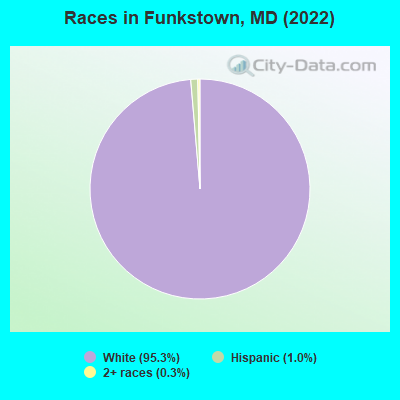
Races in Funkstown detailed stats: ancestries, foreign born residents, place of birth
 Recent articles from our blog. Our writers, many of them Ph.D. graduates or candidates, create easy-to-read articles on a wide variety of topics.

 | Are these areas of Hagerstown safe? (2 replies) |
| Hagerstown - Funkstown, considering moving there? (16 replies) |
| Homebrew Store? (5 replies) |
| What's it like in Hagerstown, MD? (45 replies) |
| moving to hagerstown (23 replies) |
| Antiquing in Maryland... (5 replies) |
Latest news from Funkstown, MD collected exclusively by city-data.com from local newspapers, TV, and radio stations
Ancestries: German (41.2%), English (19.5%), Irish (14.0%), Scottish (5.7%), Italian (5.0%), Dutch (2.6%).
Current Local Time: EST time zone
Incorporated in 1840
Elevation: 500 feet
Land area: 0.34 square miles.
Population density: 2,488 people per square mile (low).
10 residents are foreign born
| This town: | 1.0% |
| Maryland: | 9.8% |
Median real estate property taxes paid for housing units with mortgages in 2022: $1,801 (0.7%)
Median real estate property taxes paid for housing units with no mortgage in 2022: $2,020 (1.0%)
Nearest city with pop. 50,000+: Frederick, MD  (19.9 miles , pop. 52,767).
Nearest city with pop. 200,000+: Washington, DC (60.8 miles , pop. 572,059).
Nearest city with pop. 1,000,000+: Philadelphia, PA (138.8 miles , pop. 1,517,550).
Nearest cities:
), ), ), ), ), ), )Latitude: 39.61 N, Longitude: 77.71 W
Property values in Funkstown, MD

Single-family new house construction building permits:
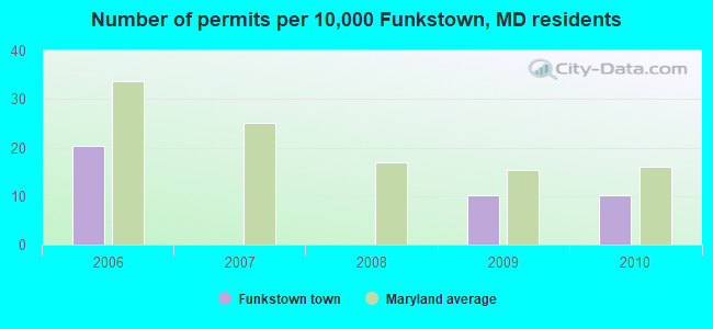
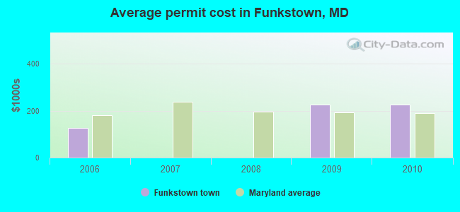
- 2010: 1 building, cost: $227,000
- 2009: 1 building, cost: $227,000
- 2006: 2 buildings, average cost: $127,500
| Here: | 2.2% |
| Maryland: | 2.0% |
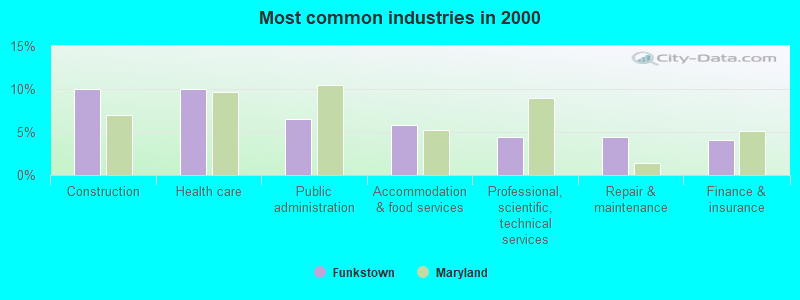
- Construction (10.0%)
- Health care (10.0%)
- Public administration (6.5%)
- Accommodation & food services (5.8%)
- Professional, scientific, technical services (4.4%)
- Repair & maintenance (4.4%)
- Finance & insurance (4.0%)
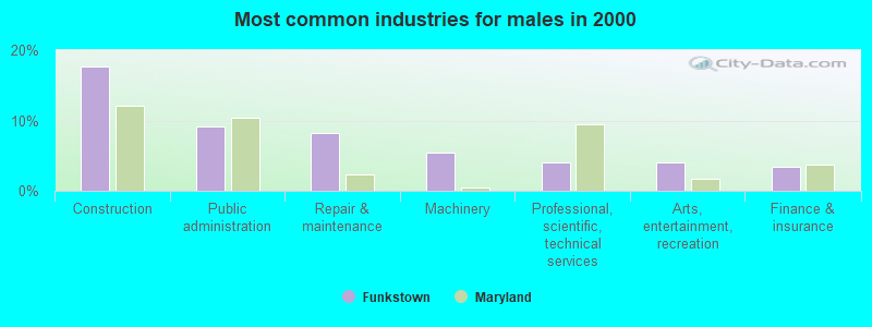
- Construction (17.7%)
- Public administration (9.2%)
- Repair & maintenance (8.2%)
- Machinery (5.4%)
- Professional, scientific, technical services (4.1%)
- Arts, entertainment, recreation (4.1%)
- Finance & insurance (3.4%)
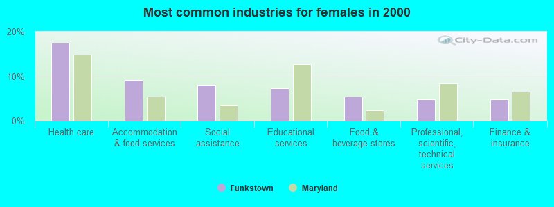
- Health care (17.5%)
- Accommodation & food services (9.1%)
- Social assistance (8.0%)
- Educational services (7.3%)
- Food & beverage stores (5.5%)
- Professional, scientific, technical services (4.7%)
- Finance & insurance (4.7%)
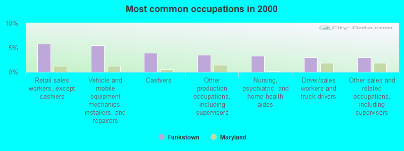
- Retail sales workers, except cashiers (5.8%)
- Vehicle and mobile equipment mechanics, installers, and repairers (5.5%)
- Cashiers (3.9%)
- Other production occupations, including supervisors (3.5%)
- Nursing, psychiatric, and home health aides (3.3%)
- Driver/sales workers and truck drivers (3.0%)
- Other sales and related occupations, including supervisors (3.0%)
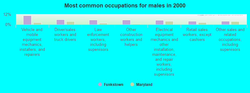
- Vehicle and mobile equipment mechanics, installers, and repairers (10.5%)
- Driver/sales workers and truck drivers (5.8%)
- Law enforcement workers, including supervisors (5.4%)
- Other construction workers and helpers (5.4%)
- Electrical equipment mechanics and other installation, maintenance, and repair workers, including supervisors (5.1%)
- Retail sales workers, except cashiers (4.1%)
- Other sales and related occupations, including supervisors (4.1%)
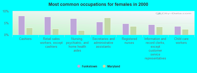
- Cashiers (8.0%)
- Retail sales workers, except cashiers (7.7%)
- Nursing, psychiatric, and home health aides (6.9%)
- Secretaries and administrative assistants (5.5%)
- Registered nurses (4.7%)
- Information and record clerks, except customer service representatives (4.4%)
- Child care workers (3.6%)
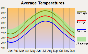
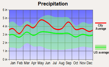
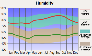
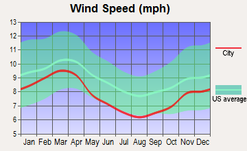
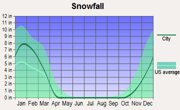
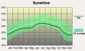
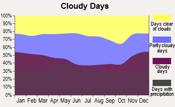
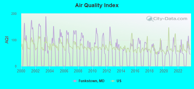
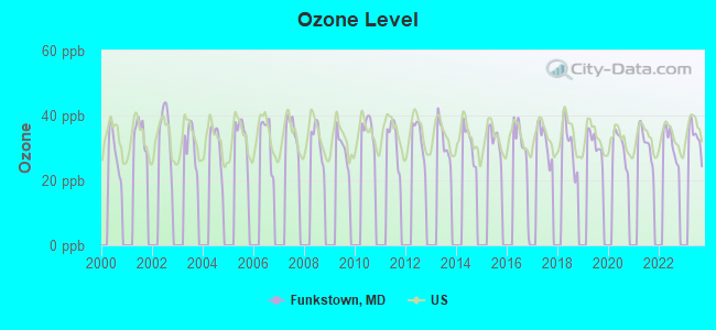
Average climate in Funkstown, Maryland
Based on data reported by over 4,000 weather stations
Tornado activity:
Funkstown-area historical tornado activity is near Maryland state average. It is 7% smaller than the overall U.S. average.
On 5/22/1983, a category F3 (max. wind speeds 158-206 mph) tornado 25.2 miles away from the Funkstown town center caused between $5000 and $50,000 in damages.
On 4/16/1961, a category F3 tornado 32.1 miles away from the town center caused between $50,000 and $500,000 in damages.
Earthquake activity:
Funkstown-area historical earthquake activity is significantly above Maryland state average. It is 55% smaller than the overall U.S. average.On 8/23/2011 at 17:51:04, a magnitude 5.8 (5.8 MW, Depth: 3.7 mi, Class: Moderate, Intensity: VI - VII) earthquake occurred 118.2 miles away from Funkstown center
On 9/25/1998 at 19:52:52, a magnitude 5.2 (4.8 MB, 4.3 MS, 5.2 LG, 4.5 MW, Depth: 3.1 mi) earthquake occurred 192.1 miles away from Funkstown center
On 1/16/1994 at 01:49:16, a magnitude 4.6 (4.6 MB, 4.6 LG, Depth: 3.1 mi, Class: Light, Intensity: IV - V) earthquake occurred 101.6 miles away from Funkstown center
On 8/25/2011 at 05:07:52, a magnitude 4.5 (4.5 ML, Depth: 4.2 mi) earthquake occurred 115.8 miles away from Funkstown center
On 12/9/2003 at 20:59:18, a magnitude 4.5 (4.5 ML, Depth: 6.2 mi) earthquake occurred 128.7 miles away from the city center
On 1/31/1986 at 16:46:43, a magnitude 5.0 (5.0 MB) earthquake occurred 227.7 miles away from the city center
Magnitude types: regional Lg-wave magnitude (LG), body-wave magnitude (MB), local magnitude (ML), surface-wave magnitude (MS), moment magnitude (MW)
Natural disasters:
The number of natural disasters in Washington County (15) is near the US average (15).Major Disasters (Presidential) Declared: 9
Emergencies Declared: 5
Causes of natural disasters: Hurricanes: 5, Floods: 3, Snowstorms: 3, Winter Storms: 3, Blizzard: 1, Heavy Rain: 1, Snowfall: 1, Storm: 1, Tropical Storm: 1, Other: 1 (Note: some incidents may be assigned to more than one category).

Hospitals and medical centers near Funkstown:
- RAVENWOOD NURSING CARE CENTER (Nursing Home, about 1 miles away; HAGERSTOWN, MD)
- MERITUS HOME HEALTH (Home Health Center, about 1 miles away; HAGERSTOWN, MD)
- MERITUS MEDICAL CENTER Acute Care Hospitals (about 2 miles away; HAGERSTOWN, MD)
- FMC - ROBINWOOD (Dialysis Facility, about 2 miles away; HAGERSTOWN, MD)
- JULIA MANOR HEALTH CARE CENTER (Nursing Home, about 2 miles away; HAGERSTOWN, MD)
- GOLDEN LIVINGCENTER-HAGERSTOWN (Nursing Home, about 2 miles away; HAGERSTOWN, MD)
- WASHINGTON COUNTY DIALYSIS (Dialysis Facility, about 2 miles away; HAGERSTOWN, MD)
Amtrak stations near Funkstown:
- 4 miles: HAGERSTOWN (GREYHOUND STA., 10527 SHARPSTOWN PK.) - Bus Station . Services: enclosed waiting area, public restrooms, public payphones, snack bar.
- 18 miles: MARTINSBURG (229 E. MARTIN ST.) . Services: fully wheelchair accessible, enclosed waiting area, public restrooms, public payphones, paid short-term parking, taxi stand, public transit connection.
- 20 miles: HARPERS FERRY (POTOMAC ST.) . Services: enclosed waiting area, public restrooms, public payphones, free short-term parking, free long-term parking, public transit connection.
Colleges/universities with over 2000 students nearest to Funkstown:
- Hagerstown Community College (about 3 miles; Hagerstown, MD; Full-time enrollment: 3,220)
- Shepherd University (about 14 miles; Shepherdstown, WV; FT enrollment: 3,745)
- Frederick Community College (about 19 miles; Frederick, MD; FT enrollment: 3,798)
- Mount St Mary's University (about 20 miles; Emmitsburg, MD; FT enrollment: 2,313)
- American Public University System (about 24 miles; Charles Town, WV; FT enrollment: 43,829)
- Gettysburg College (about 30 miles; Gettysburg, PA; FT enrollment: 2,772)
- Shippensburg University of Pennsylvania (about 33 miles; Shippensburg, PA; FT enrollment: 7,051)
Points of interest:
Notable locations in Funkstown: Funkstown Volunteer Fire Company Station 10 (A), Funkstown Town Hall (B). Display/hide their locations on the map
Churches in Funkstown include: Christ Reformed Church (A), Saint Pauls Lutheran Church (B). Display/hide their locations on the map
Cemetery: Funkstown Public Cemetery (1). Display/hide its location on the map
Drinking water stations with addresses in Funkstown that have no violations reported:
- TOWN OF FUNKSTOWN DISTRIBUTION SYSTEM (Population served: 1,300, Primary Water Source Type: Purch surface water)
| This town: | 2.1 people |
| Maryland: | 2.6 people |
| This town: | 54.2% |
| Whole state: | 67.1% |
| This town: | 10.8% |
| Whole state: | 6.4% |
Likely homosexual households (counted as self-reported same-sex unmarried-partner households)
- Lesbian couples: 0.2% of all households
- Gay men: 0.5% of all households
6 people in workers' group living quarters and job corps centers in 2010
8 people in homes for the mentally retarded in 2000
3 people in other workers' dormitories in 2000
For population 15 years and over in Funkstown:
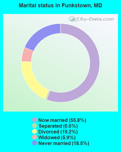
- Never married: 18.5%
- Now married: 55.8%
- Separated: 0.6%
- Widowed: 5.9%
- Divorced: 19.2%
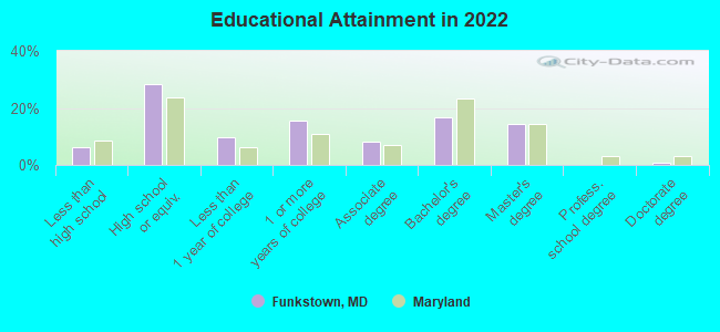
For population 25 years and over in Funkstown:
- High school or higher: 91.7%
- Bachelor's degree or higher: 29.2%
- Graduate or professional degree: 13.6%
- Unemployed: 4.1%
- Mean travel time to work (commute): 26.3 minutes
| Here: | 10.7 |
| Maryland average: | 12.7 |
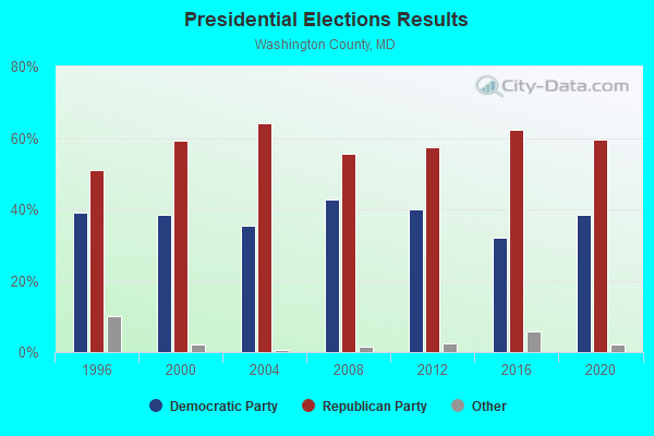
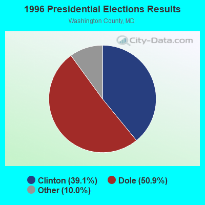
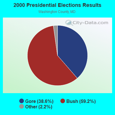
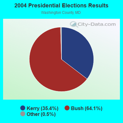
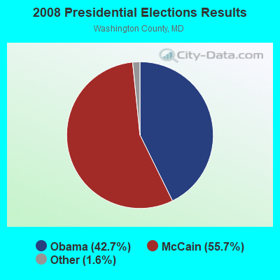
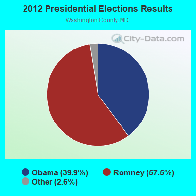
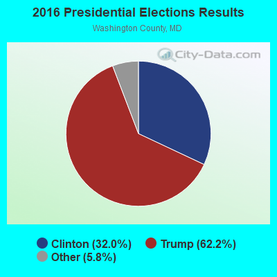

Graphs represent county-level data. Detailed 2008 Election Results
Religion statistics for Funkstown, MD (based on Washington County data)
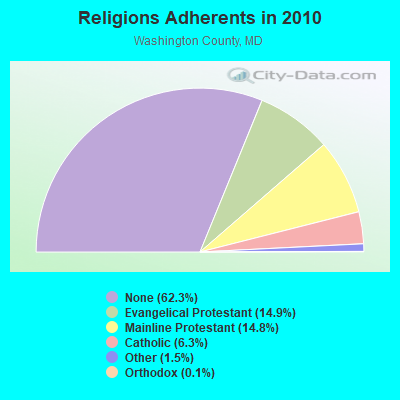
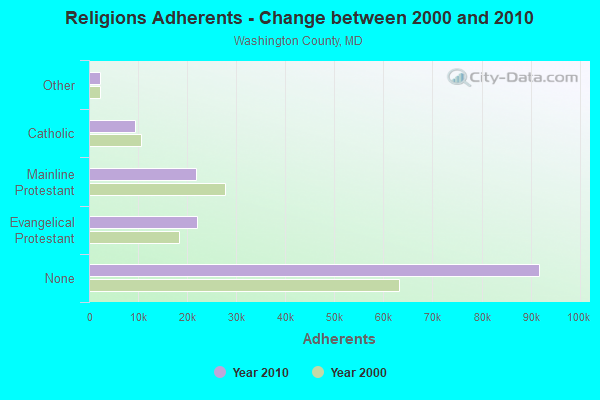
| Religion | Adherents | Congregations |
|---|---|---|
| Evangelical Protestant | 21,941 | 117 |
| Mainline Protestant | 21,837 | 79 |
| Catholic | 9,350 | 8 |
| Other | 2,244 | 11 |
| Orthodox | 163 | 2 |
| Black Protestant | 97 | 2 |
| None | 91,798 | - |
Food Environment Statistics:
| This county: | 1.73 / 10,000 pop. |
| State: | 1.96 / 10,000 pop. |
| Washington County: | 0.14 / 10,000 pop. |
| State: | 0.07 / 10,000 pop. |
| Here: | 1.04 / 10,000 pop. |
| Maryland: | 1.22 / 10,000 pop. |
| This county: | 2.83 / 10,000 pop. |
| Maryland: | 2.05 / 10,000 pop. |
| Washington County: | 6.43 / 10,000 pop. |
| Maryland: | 5.40 / 10,000 pop. |
| Washington County: | 10.2% |
| State: | 9.1% |
| This county: | 28.8% |
| Maryland: | 26.7% |
| Here: | 12.9% |
| Maryland: | 15.5% |
Health and Nutrition:
| This city: | 49.6% |
| State: | 50.1% |
| Funkstown: | 46.9% |
| State: | 47.6% |
| Here: | 29.2 |
| State: | 28.8 |
| Here: | 21.6% |
| State: | 20.0% |
| Funkstown: | 10.4% |
| Maryland: | 11.3% |
| Funkstown: | 6.8 |
| Maryland: | 6.8 |
| This city: | 36.4% |
| Maryland: | 34.1% |
| Here: | 56.8% |
| Maryland: | 56.5% |
| This city: | 77.7% |
| Maryland: | 80.5% |
More about Health and Nutrition of Funkstown, MD Residents
| Local government employment and payroll (March 2022) | |||||
| Function | Full-time employees | Monthly full-time payroll | Average yearly full-time wage | Part-time employees | Monthly part-time payroll |
|---|---|---|---|---|---|
| Other Government Administration | 2 | $6,661 | $39,966 | 0 | $0 |
| Water Supply | 1 | $3,494 | $41,928 | 0 | $0 |
| Totals for Government | 3 | $10,155 | $40,620 | 0 | $0 |
Funkstown government finances - Expenditure in 2017 (per resident):
- Current Operations - General - Other: $541,000 ($637.22)
Central Staff Services: $62,000 ($73.03)
Solid Waste Management: $55,000 ($64.78)
Regular Highways: $52,000 ($61.25)
General Public Buildings: $20,000 ($23.56)
Financial Administration: $14,000 ($16.49)
Parks and Recreation: $12,000 ($14.13)
Local Fire Protection: $5,000 ($5.89)
Judicial and Legal Services: $3,000 ($3.53)
- General - Interest on Debt: $39,000 ($45.94)
- Other Capital Outlay - Parks and Recreation: $949,000 ($1117.79)
Regular Highways: $24,000 ($28.27)
General Public Building: $3,000 ($3.53)
- Total Salaries and Wages: $115,000 ($135.45)
Funkstown government finances - Revenue in 2017 (per resident):
- Charges - Sewerage: $497,000 ($585.39)
Solid Waste Management: $61,000 ($71.85)
Other: $1,000 ($1.18)
- Federal Intergovernmental - Other: $366,000 ($431.10)
- Miscellaneous - General Revenue - Other: $6,000 ($7.07)
Rents: $2,000 ($2.36)
Interest Earnings: $1,000 ($1.18)
- State Intergovernmental - Other: $99,000 ($116.61)
Highways: $32,000 ($37.69)
- Tax - Property: $201,000 ($236.75)
Individual Income: $68,000 ($80.09)
Other Selective Sales: $23,000 ($27.09)
Amusements Sales: $7,000 ($8.24)
Public Utility License: $5,000 ($5.89)
Occupation and Business License - Other: $3,000 ($3.53)
Funkstown government finances - Debt in 2017 (per resident):
- Long Term Debt - Outstanding Unspecified Public Purpose: $1,872,000 ($2204.95)
Issue, Unspecified Public Purpose: $1,000,000 ($1177.86)
Beginning Outstanding - Unspecified Public Purpose: $985,000 ($1160.19)
Retired Unspecified Public Purpose: $113,000 ($133.10)
Funkstown government finances - Cash and Securities in 2017 (per resident):
- Other Funds - Cash and Securities: $822,000 ($968.20)
Strongest AM radio stations in Funkstown:
- WARK (1490 AM; 1 kW; HAGERSTOWN, MD; Owner: MANNING BROADCASTING, INC.)
- WHAG (1410 AM; 1 kW; HALFWAY, MD; Owner: DAME BROADCASTING, LLC)
- WJEJ (1240 AM; 1 kW; HAGERSTOWN, MD; Owner: HAGERSTOWN BROADCASTING COMPANY)
- WCBM (680 AM; 50 kW; BALTIMORE, MD; Owner: WCBM MARYLAND, INC.)
- WMET (1150 AM; 50 kW; GAITHERSBURG, MD; Owner: BELTWAY ACQUISITION CORPORATION)
- WTRI (1520 AM; daytime; 17 kW; BRUNSWICK, MD; Owner: JMK COMMUNICATIONS, INC.)
- WBAL (1090 AM; 50 kW; BALTIMORE, MD; Owner: HEARST RADIO, INC.)
- WFMD (930 AM; 5 kW; FREDERICK, MD; Owner: CAPSTAR TX LIMITED PARTNERSHIP)
- WXTR (820 AM; 4 kW; FREDERICK, MD; Owner: BONNEVILLE HOLDING COMPANY)
- WGOP (700 AM; daytime; 25 kW; WALKERSVILLE, MD; Owner: BIRACH BROADCASTING CORPORATION)
- WTEM (980 AM; 50 kW; WASHINGTON, DC; Owner: AMFM RADIO LICENSES, L.L.C.)
- WTOP (1500 AM; 50 kW; WASHINGTON, DC; Owner: BONNEVILLE HOLDING COMPANY)
- WKCW (1420 AM; 50 kW; WARRENTON, VA; Owner: WAY BROADCASTING, INC.)
Strongest FM radio stations in Funkstown:
- WDLD (96.7 FM; HALFWAY, MD; Owner: DAME BROADCASTING, LLC)
- WAYZ-FM (104.7 FM; HAGERSTOWN, MD; Owner: HJV LIMITED PARTNERSHIP)
- WETH (89.1 FM; HAGERSTOWN, MD; Owner: GREATER WASHINGTON EDUCATIONAL TELECOMMUNICATIONS ASSN.)
- WKMZ (95.9 FM; WILLIAMSPORT, MD; Owner: PRETTYMAN BROADCASTING COMPANY)
- WARX (106.9 FM; HAGERSTOWN, MD; Owner: MANNING BROADCASTING INC.)
- WFRE (99.9 FM; FREDERICK, MD; Owner: CAPSTAR TX LIMITED PARTNERSHIP)
- W219BX (91.7 FM; FREDERICK, MD; Owner: CEDAR RIDGE CHILDREN'S HOME & SCHOOL, INC)
- WCRH (90.5 FM; WILLIAMSPORT, MD; Owner: CEDAR RIDGE CHILDREN'S HOME & SCHOOL, INC)
- WWVZ (103.9 FM; BRADDOCK HEIGHTS, MD; Owner: BONNEVILLE HOLDING COMPANY)
- W219BE (91.7 FM; WAYNESBORO, PA; Owner: MARANATHA BIBLE INSTITUTE, NDBA)
- WEEO-FM (103.7 FM; MCCONNELLSBURG, PA; Owner: ALLEGHENY MOUNTAIN NETWORK)
- WLTF (97.5 FM; MARTINSBURG, WV; Owner: PRETTYMAN BROADCASTING COMPANY)
- WQCM (94.3 FM; GREENCASTLE, PA; Owner: DAME BROADCASTING, LLC)
- WAFY (103.1 FM; MIDDLETOWN, MD; Owner: FREDERICK BROADCASTING LLC)
- WSRT (92.1 FM; MERCERSBURG, PA; Owner: M. BELMONT VERSTANDIG, INC.)
- W228BA (93.5 FM; LEESBURG, VA; Owner: CSN INTERNATIONAL)
- W228AB (93.5 FM; PARAMOUNT, ETC., MD; Owner: FAMILY STATIONS, INC.)
- WINC-FM (92.5 FM; WINCHESTER, VA; Owner: MID ATLANTIC NETWORK, INC.)
- WTRM (91.3 FM; WINCHESTER, VA; Owner: TIMBER RIDGE MINISTRIES, INC.)
- WIKZ (95.1 FM; CHAMBERSBURG, PA; Owner: DAME BROADCASTING, LLC)
TV broadcast stations around Funkstown:
- W42CK (Channel 42; HAGERSTOWN, MD; Owner: THREE ANGELS BROADCASTING)
- WHAG-TV (Channel 25; HAGERSTOWN, MD; Owner: QUORUM OF MARYLAND LICENSE, LLC)
- WWPB (Channel 31; HAGERSTOWN, MD; Owner: MARYLAND PUBLIC BROADCASTING COMMISSION)
- WFPT (Channel 62; FREDERICK, MD; Owner: MARYLAND PUBLIC BROADCASTING COMMISSION)
- W52AS (Channel 52; FREDERICK, MD; Owner: THREE ANGELS BROADCASTING NETWORK)
- WWPX (Channel 60; MARTINSBURG, WV; Owner: PAXSON WASHINGTON-60 LICENSE, INC.)
- W51CY (Channel 51; CHAMBERSBURG, PA; Owner: WBDC BROADCASTING, INC.)
Funkstown fatal accident list:
Feb 21, 1990 09:35 PM, 11, Vehicles: 1, Persons: 2, Fatalities: 1
Sep 7, 1984 08:30 PM, Us0040al, Vehicles: 2, Persons: 6, Fatalities: 1, Drunk persons involved: 1
- National Bridge Inventory (NBI) Statistics
- 12Number of bridges
- 108ft / 32.6mTotal length
- $1,350,000Total costs
- 155,411Total average daily traffic
- 10,908Total average daily truck traffic
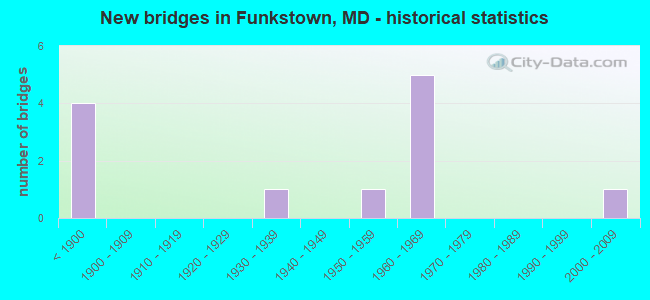
- New bridges - historical statistics
- 4Before 1900
- 11930-1939
- 11950-1959
- 51960-1969
- 12000-2009
FCC Registered Cell Phone Towers:
1- I-70 East Cell Site: 1 Mile East Of (Lat: 39.596500 Lon: -77.665000), Structure height: 76.2 m, Call Sign: KNKA787
Assigned Frequencies: 880.020 MHz, 880.020 MHz, 891.510 MHz, 891.510 MHz, 835.020 MHz, 835.020 MHz, 846.510 MHz, 846.510 MHzGrant Date: 09/10/2019, Expiration Date: 10/01/2029, Certifier: Steven T CampbellRegistrant: Wilkinson Barker Knauer, LLP, 1800 M Street Nw, Suite 800n, Washington, DC 20036, Phone: (202) 383-3420, Fax: (202) 783-5851, Email:
FCC Registered Antenna Towers:
6- Brian J Hargraves, 10300 Mapleville Rd, C Route 66 (Site Name: Beaver Creek) (Lat: 39.596056 Lon: -77.642361), Type: 59.4, Overall height: 59.4 m, Registrant: American Tower Corporation, Www.Americantower.Com, , Bosto-n, Phone: (617) 585-7600
- Brian J Hargraves, 10300 Mapleville Rd, C Route 66 (Site Name: Beaver Creek) (Lat: 39.596056 Lon: -77.642361), Type: 59.4, Overall height: 59.4 m, Registrant: American Tower Corporation, Www.Americantower.Com, , Bosto-n, Phone: (617) 585-7600
- Sean O'Malley, 10300 Mapleville Rd, C Route 66 (Site Name: Beaver Creek) (Lat: 39.596056 Lon: -77.642361), Type: 59.4, Overall height: 59.4 m, Registrant: Faa/Fcc Compliance Specialist, Bosto-n, Phone: (617) 585-7600
- Sean O'Malley, 10300 Mapleville Rd, C Route 66 (Site Name: Beaver Creek) (Lat: 39.596056 Lon: -77.642361), Type: 59.4, Overall height: 59.4 m, Registrant: American Towers, Inc., Bosto-n, Phone: (617) 585-7600
- Sean O'Malley, 10300 Mapleville Rd, C Route 66 (01030) (Lat: 39.596056 Lon: -77.642361), Type: 60.9, Overall height: 59.4 m, Registrant: American Towers, Inc., Bosto-n, Phone: (617) 585-7600
- Sean O'Malley, 10300 Mapleville Rd, C Route 66 (01030) (Lat: 39.596056 Lon: -77.642361), Type: 60.9, Overall height: 59.4 m, Registrant: American Towers, Inc., Bosto-n, Phone: (617) 585-7600
FCC Registered Broadcast Land Mobile Towers:
1- Funkstown Volunteer Fire Company Inc West Side Ave (Lat: 39.610361 Lon: -77.711111), Call Sign: KXM960,
Assigned Frequencies: 33.8400 MHz, 33.8600 MHz, Grant Date: 11/20/2013, Expiration Date: 02/08/2024, Registrant: Wash. Co. Wireless Communications, 35 W. Washington St, Hagerstown, MD 21740, Phone: (240) 313-2070
FCC Registered Microwave Towers:
2- STATION, 4.1 Mi Se (Lat: 39.564528 Lon: -77.654139), Overall height: 58.8 m, Call Sign: WNTM426,
Assigned Frequencies: 928.568 MHz, 952.568 MHz, Grant Date: 02/25/1992, Expiration Date: 02/25/1997, Cancellation Date: 01/19/1995, Phone: (919) 545-2223
- FUNKSTOWN, 4.1 Mi Se Of (Lat: 39.564250 Lon: -77.654139), Overall height: 58.5 m, Call Sign: WLU930, Licensee ID: L00128694,
Assigned Frequencies: 2121.60 MHz, Grant Date: 03/13/2001, Expiration Date: 02/01/2011, Cancellation Date: 11/23/2010, Certifier: Michael P Goggin, Registrant: New Cingular Wireless Pcs, LLC
FCC Registered Amateur Radio Licenses:
10 (See the full list of FCC Registered Amateur Radio Licenses in Funkstown)2002 - 2018 National Fire Incident Reporting System (NFIRS) incidents
- Fire incident types reported to NFIRS in Funkstown, MD
- 9872.6%Structure Fires
- 2216.3%Outside Fires
- 107.4%Mobile Property/Vehicle Fires
- 53.7%Other
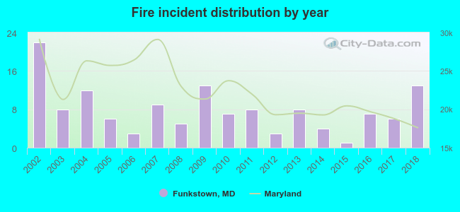 According to the data from the years 2002 - 2018 the average number of fires per year is 8. The highest number of reported fires - 22 took place in 2002, and the least - 1 in 2015. The data has a declining trend.
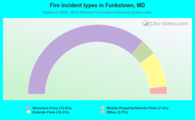 When looking into fire subcategories, the most reports belonged to: Structure Fires (72.6%), and Outside Fires (16.3%).
| Most common first names in Funkstown, MD among deceased individuals | ||
| Name | Count | Lived (average) |
|---|---|---|
| Charles | 14 | 77.7 years |
| William | 11 | 77.0 years |
| Richard | 11 | 67.1 years |
| Helen | 10 | 80.3 years |
| George | 9 | 71.0 years |
| Mary | 9 | 75.6 years |
| Margaret | 7 | 79.3 years |
| James | 7 | 75.0 years |
| John | 7 | 76.4 years |
| Paul | 7 | 73.4 years |
| Most common last names in Funkstown, MD among deceased individuals | ||
| Last name | Count | Lived (average) |
|---|---|---|
| Smith | 11 | 80.9 years |
| Bowers | 6 | 68.5 years |
| Waugh | 6 | 80.3 years |
| Marshall | 5 | 70.0 years |
| Davis | 5 | 77.6 years |
| Bailey | 5 | 75.8 years |
| Iseminger | 5 | 83.8 years |
| Renner | 5 | 82.8 years |
| Baumann | 4 | 74.3 years |
| Duffey | 4 | 69.8 years |
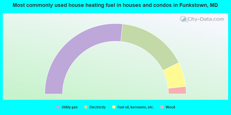
- 53.2%Utility gas
- 32.1%Electricity
- 11.3%Fuel oil, kerosene, etc.
- 3.4%Wood
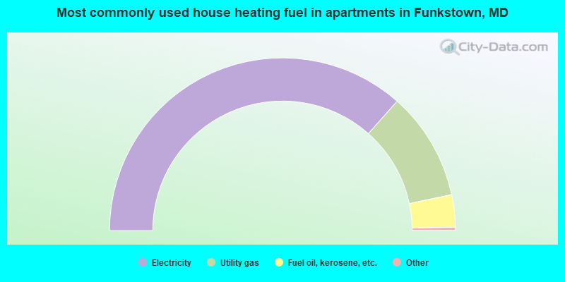
- 73.5%Electricity
- 20.4%Utility gas
- 6.1%Fuel oil, kerosene, etc.
Funkstown compared to Maryland state average:
- Median household income below state average.
- Median house value below state average.
- Unemployed percentage significantly below state average.
- Black race population percentage significantly below state average.
- Hispanic race population percentage significantly below state average.
- Median age significantly above state average.
- Foreign-born population percentage significantly below state average.
- Length of stay since moving in significantly above state average.
- House age above state average.