Goshen, Massachusetts
Submit your own pictures of this town and show them to the world
- OSM Map
- General Map
- Google Map
- MSN Map
Population change since 2000: +14.4%
 |
| Males: 513 | |
| Females: 541 |
| Median resident age: | 45.5 years |
| Massachusetts median age: | 39.2 years |
Zip codes: 01096.
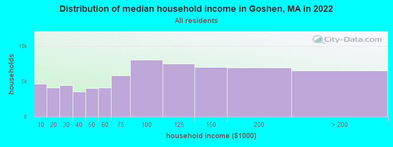
| Goshen: | $88,283 |
| MA: | $94,488 |
Estimated per capita income in 2022: $42,623 (it was $22,221 in 2000)
Goshen town income, earnings, and wages data
Estimated median house or condo value in 2022: $364,103 (it was $140,100 in 2000)
| Goshen: | $364,103 |
| MA: | $534,700 |
Mean prices in 2022: all housing units: $406,762; detached houses: $418,541; townhouses or other attached units: $363,334; in 2-unit structures: $269,911; in 3-to-4-unit structures: $561,325; in 5-or-more-unit structures: $236,751; mobile homes: $362,036
Detailed information about poverty and poor residents in Goshen, MA
Compare current foreclosures near Goshen, MA:
| Photo | Address | Area | Beds / Baths | Price | Details |
|---|---|---|---|---|---|

|
#1
Cold Spring Rd
Southampton, MA 01073
|
2,736 sq. feet
|
1 baths 3 beds |
$284,900
|
show details |

|
#2
West St
Greenfield, MA 01301
|
1,858 sq. feet
|
2 baths 3 beds |
show details | |

|
#3
South St
Ashfield, MA 01330
|
4,386 sq. feet
|
3 baths 6 beds |
show details | |

|
#4
Lord St
Easthampton, MA 01027
|
1,048 sq. feet
|
1 baths 3 beds |
show details | |

|
#5
Chapman St
Greenfield, MA 01301
|
1,472 sq. feet
|
1 baths 2 beds |
show details | |

|
#6
Kosior Dr
Hadley, MA 01035
|
1,040 sq. feet
|
1 baths 2 beds |
show details | |

|
#7
Loop Rd
Savoy, MA 01256
|
1,040 sq. feet
|
1 baths 3 beds |
show details | |

|
#8
Plumtree Rd
Sunderland, MA 01375
|
1,536 sq. feet
|
2 baths 2 beds |
show details | |

|
#9
Legate Hill Rd
Charlemont, MA 01339
|
2,016 sq. feet
|
2 baths 3 beds |
show details | |

|
#10
Legate Hill Rd
Charlemont, MA 01339
|
2,016 sq. feet
|
2 baths 3 beds |
show details |
| Photo | Address | Area | Beds / Baths | Price | Details |
|---|---|---|---|---|---|

|
#11
Lewandowski Ave
Easthampton, MA 01027
|
1,056 sq. feet
|
1 baths 2 beds |
show details | |

|
#12
Allman Dr
Chester, MA 01011
|
1,664 sq. feet
|
2 baths 4 beds |
show details | |

|
#13
Park St
Easthampton, MA 01027
|
1,064 sq. feet
|
1 baths 2 beds |
show details | |

|
#14
Meridian St
Greenfield, MA 01301
|
768 sq. feet
|
1 baths 2 beds |
show details | |

|
#15
Maple St
Greenfield, MA 01301
|
1,216 sq. feet
|
1 baths 3 beds |
show details | |

|
#16
Pine St
Amherst, MA 01002
|
2,195 sq. feet
|
2 baths 4 beds |
show details | |

|
#17
Tea St
Charlemont, MA 01339
|
2,829 sq. feet
|
2 baths 6 beds |
show details | |

|
#18
Holyoke St
Easthampton, MA 01027
|
1,106 sq. feet
|
1 baths 2 beds |
show details | |

|
#19
Sand Hill Rd
Amherst, MA 01002
|
2,037 sq. feet
|
3 baths 5 beds |
show details | |

|
#20
Hope St
Greenfield, MA 01301
|
1,619 sq. feet
|
1 baths 3 beds |
show details |
| Photo | Address | Area | Beds / Baths | Price | Details |
|---|---|---|---|---|---|

|
#21
James St
Greenfield, MA 01301
|
2,176 sq. feet
|
2 baths 4 beds |
show details | |

|
#22
Elm St
Greenfield, MA 01301
|
1,160 sq. feet
|
1 baths 3 beds |
show details | |

|
#23
Forest Ave
Greenfield, MA 01301
|
1,764 sq. feet
|
1 baths 4 beds |
show details | |

|
#24
Garfield St
Greenfield, MA 01301
|
2,260 sq. feet
|
2 baths 4 beds |
show details | |

|
#25
Ledgewood Dr
Sunderland, MA 01375
|
2,119 sq. feet
|
2 baths 3 beds |
show details | |

|
#26
Shays St # 1
Amherst, MA 01002
|
925 sq. feet
|
2 baths 3 beds |
show details | |

|
#27
Priestly Farms Rd
South Hadley, MA 01075
|
3,004 sq. feet
|
3 baths 3 beds |
show details | |

|
#28
W Hawley Rd
Charlemont, MA 01339
|
1,440 sq. feet
|
1 baths 2 beds |
show details | |

|
#29
Pine St
South Hadley, MA 01075
|
1,536 sq. feet
|
2 baths 3 beds |
show details | |

|
#30
Chesterfield Rd
Easthampton, MA 01027
|
3,977 sq. feet
|
2 baths 6 beds |
show details |
| Photo | Address | Area | Beds / Baths | Price | Details |
|---|---|---|---|---|---|

|
#31
Alvord Pl
South Hadley, MA 01075
|
1,358 sq. feet
|
2 baths 2 beds |
show details | |

|
#32
Sabans Rd
Conway, MA 01341
|
1,246 sq. feet
|
1 baths 3 beds |
show details | |

|
#33
Old North Rd
Worthington, MA 01098
|
2,369 sq. feet
|
3 baths 4 beds |
show details | |

|
#34
Chestnut St
West Hatfield, MA 01088
|
1,248 sq. feet
|
1 baths 3 beds |
show details | |

|
#35
Brierwood Dr
Florence, MA 01062
|
960 sq. feet
|
1 baths 3 beds |
show details | |

|
#36
Cahillane Ter
Florence, MA 01062
|
1,388 sq. feet
|
1 baths 3 beds |
show details | |

|
#37
Long Plain Rd
South Deerfield, MA 01373
|
1,909 sq. feet
|
2 baths 4 beds |
show details | |

|
#38
Alvord Pl
South Hadley, MA 01075
|
1,358 sq. feet
|
2 baths 2 beds |
show details | |

|
#39
Braeburn Rd
South Deerfield, MA 01373
|
1,661 sq. feet
|
1 baths 3 beds |
show details | |

|
#40
Dell St
Turners Falls, MA 01376
|
720 sq. feet
|
1 baths 1 beds |
show details |
| Photo | Address | Area | Beds / Baths | Price | Details |
|---|---|---|---|---|---|

|
#41
Bridge St # 1
Hatfield, MA 01038
|
3,300 sq. feet
|
3 baths 4 beds |
show details | |

|
#42
Alvord Pl
South Hadley, MA 01075
|
1,358 sq. feet
|
3 baths 3 beds |
show details | |

|
#43
N Main St
South Deerfield, MA 01373
|
2,143 sq. feet
|
1 baths 5 beds |
show details | |

|
#44
David Dr
Hinsdale, MA 01235
|
1,664 sq. feet
|
2 baths 3 beds |
show details | |

|
#45
North St
Hatfield, MA 01038
|
1,900 sq. feet
|
1 baths 3 beds |
show details | |

|
#46
Sunderland Rd
South Deerfield, MA 01373
|
1,385 sq. feet
|
1 baths 3 beds |
show details | |

|
#47
Myrtle St # 1
Northampton, MA 01060
|
2,222 sq. feet
|
2 baths 4 beds |
show details | |

|
#48
Central Park Dr
Holyoke, MA 01040
|
2,855 sq. feet
|
2 baths 3 beds |
show details | |

|
#49
Glendale Rd
Southampton, MA 01073
|
1,303 sq. feet
|
1 baths 4 beds |
show details | |

|
Check over 1 million property listings on Foreclosure.com!
|
browse all offers | |||

- 1,02297.0%White alone
- 121.1%Hispanic
- 111.0%Two or more races
- 30.3%Black alone
- 30.3%American Indian alone
- 30.3%Asian alone
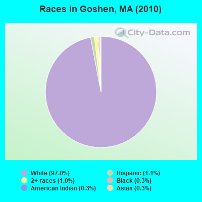
Races in Goshen detailed stats: ancestries, foreign born residents, place of birth
Type |
2009 |
2010 |
2011 |
2012 |
2013 |
2014 |
2015 |
2016 |
2017 |
2018 |
2019 |
2020 |
2022 |
|---|---|---|---|---|---|---|---|---|---|---|---|---|---|
| Murders (per 100,000) | 0 (0.0) | 0 (0.0) | 0 (0.0) | 0 (0.0) | 0 (0.0) | 0 (0.0) | 0 (0.0) | 0 (0.0) | 0 (0.0) | 0 (0.0) | 0 (0.0) | 0 (0.0) | 0 (0.0) |
| Rapes (per 100,000) | 0 (0.0) | 0 (0.0) | 1 (94.3) | 0 (0.0) | 0 (0.0) | 0 (0.0) | 0 (0.0) | 0 (0.0) | 0 (0.0) | 0 (0.0) | 0 (0.0) | 0 (0.0) | 0 (0.0) |
| Robberies (per 100,000) | 0 (0.0) | 0 (0.0) | 0 (0.0) | 0 (0.0) | 0 (0.0) | 0 (0.0) | 0 (0.0) | 0 (0.0) | 0 (0.0) | 0 (0.0) | 0 (0.0) | 0 (0.0) | 0 (0.0) |
| Assaults (per 100,000) | 0 (0.0) | 0 (0.0) | 1 (94.3) | 0 (0.0) | 0 (0.0) | 0 (0.0) | 0 (0.0) | 1 (93.2) | 1 (93.1) | 0 (0.0) | 0 (0.0) | 0 (0.0) | 0 (0.0) |
| Burglaries (per 100,000) | 1 (102.0) | 3 (284.6) | 2 (188.7) | 3 (282.5) | 1 (94.6) | 0 (0.0) | 3 (279.6) | 1 (93.2) | 4 (372.4) | 0 (0.0) | 2 (187.8) | 1 (94.4) | 0 (0.0) |
| Thefts (per 100,000) | 3 (306.1) | 4 (379.5) | 5 (471.7) | 1 (94.2) | 1 (94.6) | 1 (94.4) | 0 (0.0) | 1 (93.2) | 3 (279.3) | 3 (281.2) | 2 (187.8) | 2 (188.9) | 2 (211.6) |
| Auto thefts (per 100,000) | 1 (102.0) | 1 (94.9) | 0 (0.0) | 0 (0.0) | 0 (0.0) | 0 (0.0) | 0 (0.0) | 1 (93.2) | 0 (0.0) | 0 (0.0) | 0 (0.0) | 0 (0.0) | 0 (0.0) |
| Arson (per 100,000) | 0 (0.0) | 0 (0.0) | 0 (0.0) | 0 (0.0) | 0 (0.0) | 0 (0.0) | 0 (0.0) | 0 (0.0) | 0 (0.0) | 0 (0.0) | 0 (0.0) | 0 (0.0) | 0 (0.0) |
| City-Data.com crime index | 27.6 | 42.7 | 126.4 | 23.5 | 10.4 | 3.8 | 19.6 | 36.3 | 55.9 | 11.2 | 20.7 | 14.2 | 8.5 |
The City-Data.com crime index weighs serious crimes and violent crimes more heavily. Higher means more crime, U.S. average is 246.1. It adjusts for the number of visitors and daily workers commuting into cities.
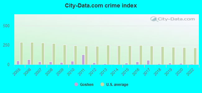
Crime rate in Goshen detailed stats: murders, rapes, robberies, assaults, burglaries, thefts, arson
Full-time law enforcement employees in 2020, including police officers: 2 (2 officers - 1 male; 1 female).
| Officers per 1,000 residents here: | 1.89 |
| Massachusetts average: | 2.59 |
 Recent articles from our blog. Our writers, many of them Ph.D. graduates or candidates, create easy-to-read articles on a wide variety of topics.

 | Hillbilly Massachusetts (103 replies) |
| Big MA Ancestry Data Thread by Town (31 replies) |
| Is it possible to escape hunters, ATVs and noise in a rural area? (278 replies) |
| MBTA to raise fares 6.3% (199 replies) |
| Winter Commute to Northampton (24 replies) |
| How Much Massachusetts Households Make Per Year: Census Data (37 replies) |
Latest news from Goshen, MA collected exclusively by city-data.com from local newspapers, TV, and radio stations
Ancestries: English (17.9%), Irish (15.2%), Polish (13.8%), French (12.8%), French Canadian (12.8%), German (12.3%).
Current Local Time: EST time zone
Incorporated in 1781
Elevation: 1450 feet
Land area: 17.4 square miles.
Population density: 61 people per square mile (very low).
12 residents are foreign born
| This town: | 1.3% |
| Massachusetts: | 12.2% |
| Goshen town: | 1.4% ($2,005) |
| Massachusetts: | 1.3% ($2,336) |
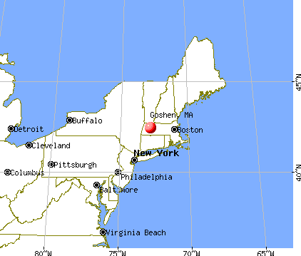
Nearest city with pop. 50,000+: Chicopee, MA  (21.3 miles , pop. 54,653).
Nearest city with pop. 200,000+: Boston, MA (88.0 miles , pop. 589,141).
Nearest city with pop. 1,000,000+: Bronx, NY (122.8 miles , pop. 1,332,650).
Nearest cities:
), ), ), ), ), ), Latitude: 42.43 N, Longitude: 72.80 W
Area code commonly used in this area: 413

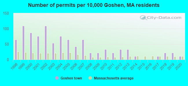
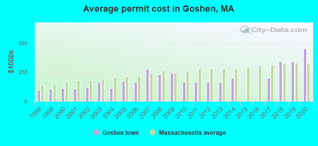
Single-family new house construction building permits:
- 2020: 1 building, cost: $453,100
- 2019: 2 buildings, average cost: $342,500
- 2018: 2 buildings, average cost: $342,500
- 2017: 1 building, cost: $200,000
- 2014: 1 building, cost: $200,000
- 2013: 3 buildings, average cost: $165,000
- 2012: 3 buildings, average cost: $165,000
- 2011: 2 buildings, average cost: $165,000
- 2010: 3 buildings, average cost: $165,000
- 2009: 2 buildings, average cost: $245,000
- 2008: 2 buildings, average cost: $230,000
- 2007: 6 buildings, average cost: $277,200
- 2006: 4 buildings, average cost: $162,800
- 2005: 6 buildings, average cost: $170,400
- 2004: 7 buildings, average cost: $114,300
- 2003: 5 buildings, average cost: $164,000
- 2002: 10 buildings, average cost: $118,600
- 2001: 7 buildings, average cost: $108,100
- 2000: 8 buildings, average cost: $113,100
- 1999: 10 buildings, average cost: $106,000
- 1998: 6 buildings, average cost: $96,800
| Here: | 1.2% |
| Massachusetts: | 3.5% |
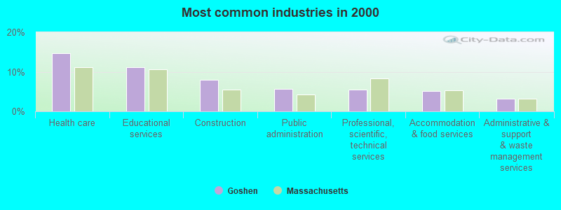
- Health care (14.6%)
- Educational services (11.2%)
- Construction (8.0%)
- Public administration (5.7%)
- Professional, scientific, technical services (5.5%)
- Accommodation & food services (5.1%)
- Administrative & support & waste management services (3.1%)
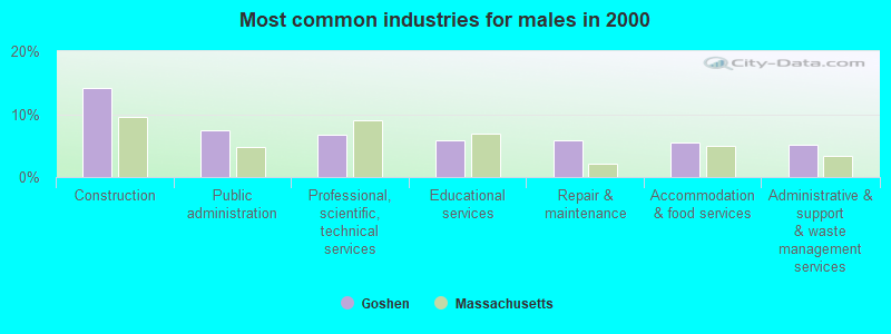
- Construction (14.1%)
- Public administration (7.4%)
- Professional, scientific, technical services (6.7%)
- Educational services (5.9%)
- Repair & maintenance (5.9%)
- Accommodation & food services (5.6%)
- Administrative & support & waste management services (5.2%)
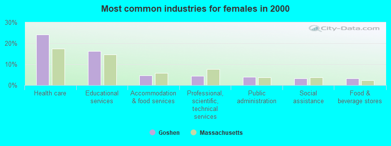
- Health care (24.2%)
- Educational services (16.2%)
- Accommodation & food services (4.7%)
- Professional, scientific, technical services (4.3%)
- Public administration (4.0%)
- Social assistance (3.2%)
- Food & beverage stores (3.2%)
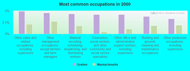
- Other sales and related occupations, including supervisors (4.9%)
- Other management occupations, except farmers and farm managers (4.6%)
- Material recording, scheduling, dispatching, and distributing workers (4.4%)
- Counselors, social workers, and other community and social service specialists (4.2%)
- Other office and administrative support workers, including supervisors (4.2%)
- Building and grounds cleaning and maintenance occupations (3.8%)
- Other production occupations, including supervisors (3.3%)
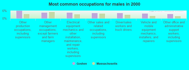
- Other production occupations, including supervisors (5.9%)
- Other management occupations, except farmers and farm managers (4.8%)
- Electrical equipment mechanics and other installation, maintenance, and repair workers, including supervisors (4.8%)
- Other sales and related occupations, including supervisors (4.4%)
- Driver/sales workers and truck drivers (4.4%)
- Vehicle and mobile equipment mechanics, installers, and repairers (4.1%)
- Other office and administrative support workers, including supervisors (3.7%)
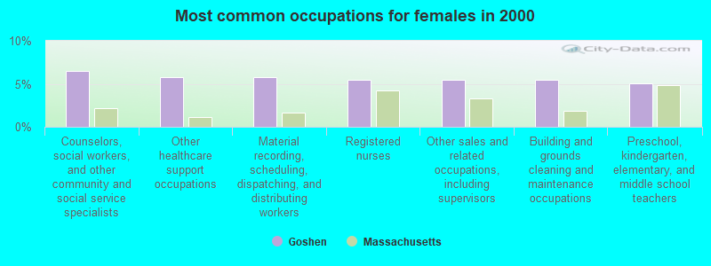
- Counselors, social workers, and other community and social service specialists (6.5%)
- Other healthcare support occupations (5.8%)
- Material recording, scheduling, dispatching, and distributing workers (5.8%)
- Registered nurses (5.4%)
- Other sales and related occupations, including supervisors (5.4%)
- Building and grounds cleaning and maintenance occupations (5.4%)
- Preschool, kindergarten, elementary, and middle school teachers (5.1%)
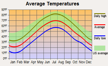
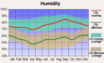
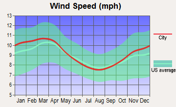
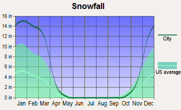
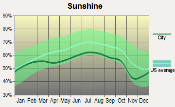
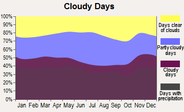
Average climate in Goshen, Massachusetts
Based on data reported by over 4,000 weather stations
(lower is better)
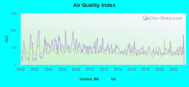
Air Quality Index (AQI) level in 2022 was 75.1. This is about average.
| City: | 75.1 |
| U.S.: | 72.6 |
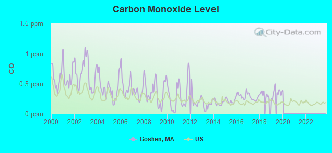
Carbon Monoxide (CO) [ppm] level in 2019 was 0.346. This is worse than average. Closest monitor was 19.7 miles away from the city center.
| City: | 0.346 |
| U.S.: | 0.251 |
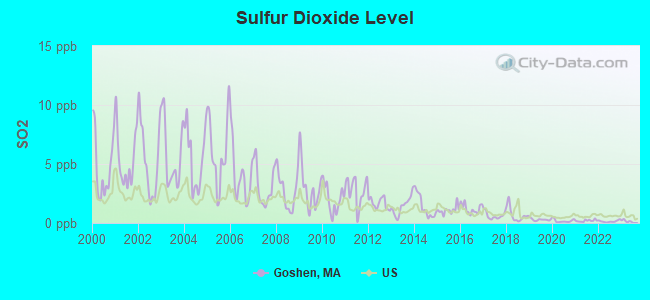
Sulfur Dioxide (SO2) [ppb] level in 2022 was 0.141. This is significantly better than average. Closest monitor was 12.6 miles away from the city center.
| City: | 0.141 |
| U.S.: | 1.515 |
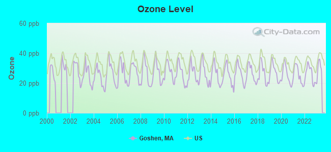
Ozone [ppb] level in 2022 was 26.0. This is better than average. Closest monitor was 14.3 miles away from the city center.
| City: | 26.0 |
| U.S.: | 33.3 |
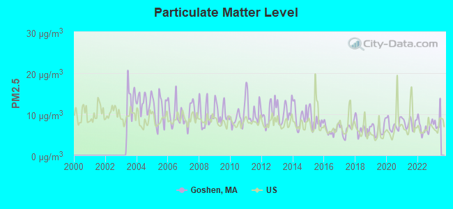
Particulate Matter (PM2.5) [µg/m3] level in 2022 was 6.83. This is about average. Closest monitor was 16.0 miles away from the city center.
| City: | 6.83 |
| U.S.: | 8.11 |
Tornado activity:
Goshen-area historical tornado activity is above Massachusetts state average. It is 12% smaller than the overall U.S. average.
On 5/29/1995, a category F4 (max. wind speeds 207-260 mph) tornado 26.0 miles away from the Goshen town center killed 3 people and injured 24 people and caused between $5,000,000 and $50,000,000 in damages.
On 10/3/1979, a category F4 tornado 27.0 miles away from the town center killed 3 people and injured 500 people and caused between $50,000,000 and $500,000,000 in damages.
Earthquake activity:
Goshen-area historical earthquake activity is significantly above Massachusetts state average. It is 69% smaller than the overall U.S. average.On 10/7/1983 at 10:18:46, a magnitude 5.3 (5.1 MB, 5.3 LG, 5.1 ML, Class: Moderate, Intensity: VI - VII) earthquake occurred 130.6 miles away from the city center
On 4/20/2002 at 10:50:47, a magnitude 5.3 (5.3 ML, Depth: 3.0 mi) earthquake occurred 150.7 miles away from the city center
On 4/20/2002 at 10:50:47, a magnitude 5.2 (5.2 MB, 4.2 MS, 5.2 MW, 5.0 MW) earthquake occurred 149.3 miles away from the city center
On 1/19/1982 at 00:14:42, a magnitude 4.7 (4.5 MB, 4.7 MD, 4.5 LG, Class: Light, Intensity: IV - V) earthquake occurred 95.8 miles away from the city center
On 10/16/2012 at 23:12:25, a magnitude 4.7 (4.7 ML, Depth: 10.0 mi) earthquake occurred 135.3 miles away from the city center
On 6/17/1991 at 08:53:16, a magnitude 4.1 (4.0 MB, 4.0 LG, Depth: 3.1 mi) earthquake occurred 96.4 miles away from Goshen center
Magnitude types: regional Lg-wave magnitude (LG), body-wave magnitude (MB), duration magnitude (MD), local magnitude (ML), surface-wave magnitude (MS), moment magnitude (MW)
Natural disasters:
The number of natural disasters in Hampshire County (21) is greater than the US average (15).Major Disasters (Presidential) Declared: 10
Emergencies Declared: 10
Causes of natural disasters: Floods: 5, Snowstorms: 5, Storms: 5, Hurricanes: 4, Winter Storms: 4, Blizzards: 2, Snows: 2, Snowfall: 1, Tropical Storm: 1, Wind: 1, Other: 1 (Note: some incidents may be assigned to more than one category).
Hospitals and medical centers near Goshen:
- OVERLOOK AT NORTHAMPTON (Nursing Home, about 7 miles away; LEEDS, MA)
- LINDA MANOR EXTENDED CARE FACILITY (Nursing Home, about 8 miles away; LEEDS, MA)
- NORTHAMPTON VA MEDICAL CENTER (Hospital, Acute Care - Veterans Administration, about 9 miles away; LEEDS, MA)
- NORTHAMPTON REHABILITATION AND NURSING CENTER (Nursing Home, about 11 miles away; NORTHAMPTON, MA)
- SERVICENET HOMECARE (Home Health Center, about 11 miles away; NORTHAMPTON, MA)
- COOLEY DICKINSON HOSPITAL INC,THE Acute Care Hospitals (about 11 miles away; NORTHAMPTON, MA)
- CALVIN COOLIDGE NURING AND REHAB CTR - NORTHAMPTON (Nursing Home, about 11 miles away; NORTHAMPTON, MA)
Colleges/universities with over 2000 students nearest to Goshen:
- Smith College (about 12 miles; Northampton, MA; Full-time enrollment: 3,549)
- University of Massachusetts-Amherst (about 15 miles; Amherst, MA; FT enrollment: 26,583)
- Mount Holyoke College (about 17 miles; South Hadley, MA; FT enrollment: 2,573)
- Holyoke Community College (about 19 miles; Holyoke, MA; FT enrollment: 4,911)
- Westfield State University (about 21 miles; Westfield, MA; FT enrollment: 5,548)
- Springfield Technical Community College (about 26 miles; Springfield, MA; FT enrollment: 4,750)
- American International College (about 26 miles; Springfield, MA; FT enrollment: 2,733)
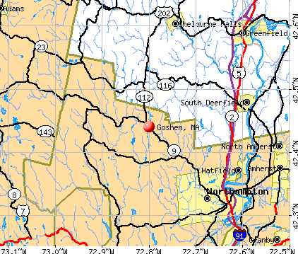
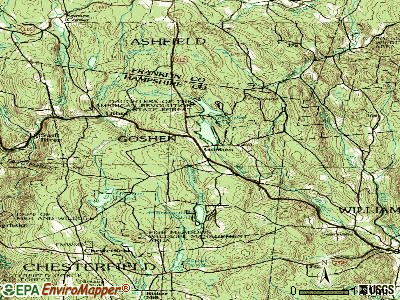
Points of interest:
Notable locations in Goshen: Camp Holy Cross (A), Camp Howe (B), Highland Ambulance EMS (C), Goshen Fire Department (D). Display/hide their locations on the map
Cemetery: Goshen Cemetery (1). Display/hide its location on the map
Lakes and reservoirs: Lilly Pond (A), Highland Lakes (B), Hammond Pond (C), Sears Meadow Reservoir (D), Lower Highland Lake (E), Upper Highland Lake (F). Display/hide their locations on the map
Streams, rivers, and creeks: Fuller Brook (A), East Brook (B), Stones Brook (C). Display/hide their locations on the map
| This town: | 2.5 people |
| Massachusetts: | 2.5 people |
| This town: | 70.9% |
| Whole state: | 63.0% |
| This town: | 12.0% |
| Whole state: | 7.0% |
Likely homosexual households (counted as self-reported same-sex unmarried-partner households)
- Lesbian couples: 2.9% of all households
- Gay men: 0.7% of all households
| This town: | 7.9% |
| Whole state: | 9.3% |
| This town: | 3.7% |
| Whole state: | 4.4% |
For population 15 years and over in Goshen:
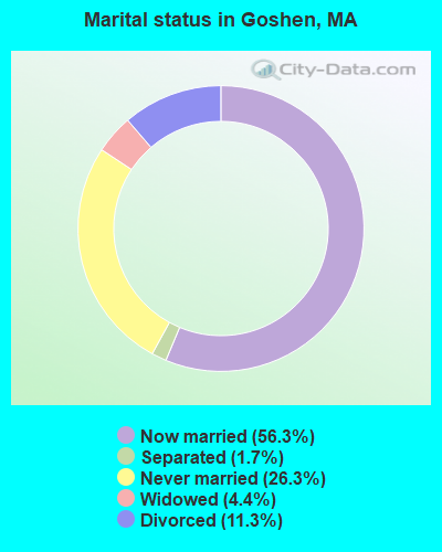
- Never married: 26.3%
- Now married: 56.3%
- Separated: 1.7%
- Widowed: 4.4%
- Divorced: 11.3%
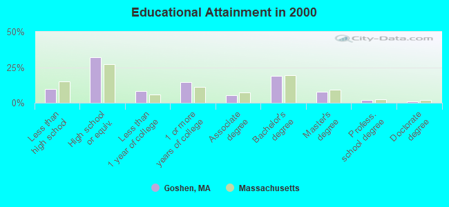
For population 25 years and over in Goshen:
- High school or higher: 90.3%
- Bachelor's degree or higher: 30.1%
- Graduate or professional degree: 11.0%
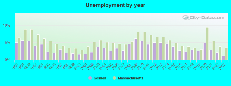
- Unemployed: 3.4%
- Mean travel time to work (commute): 31.0 minutes
| Here: | 9.8 |
| Massachusetts average: | 13.1 |
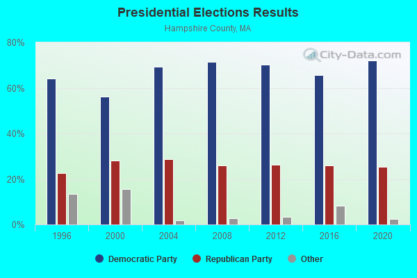
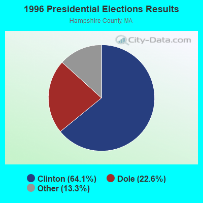
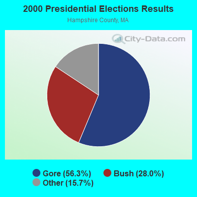
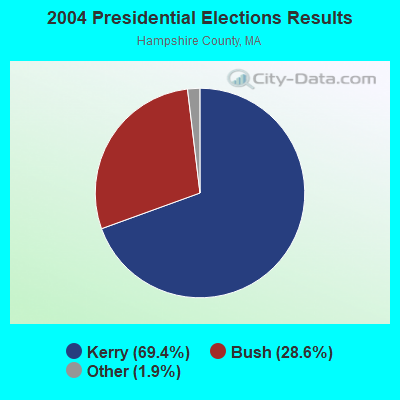
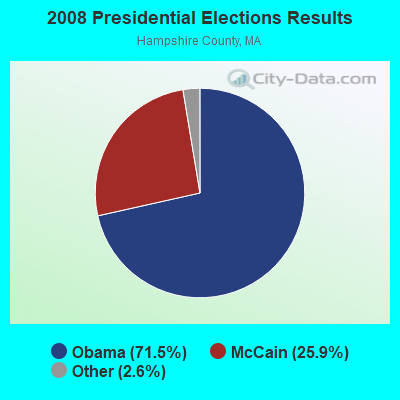
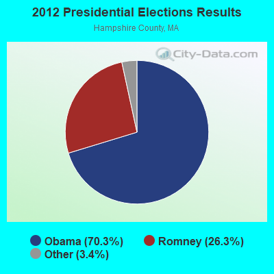
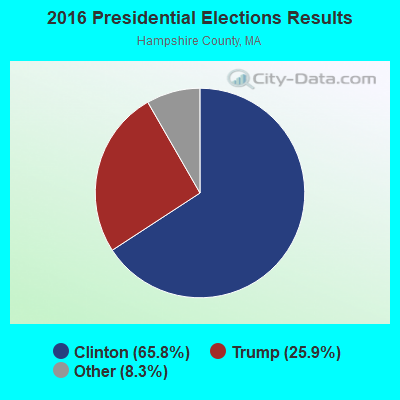
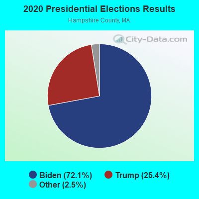
Graphs represent county-level data. Detailed 2008 Election Results
Religion statistics for Goshen, MA (based on Hampshire County data)
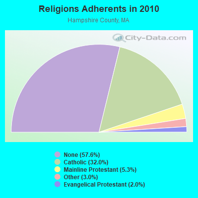
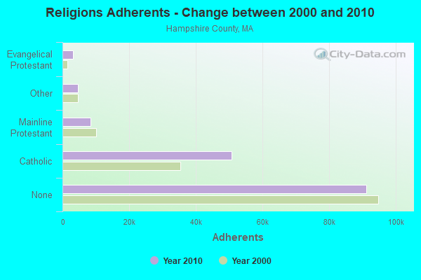
| Religion | Adherents | Congregations |
|---|---|---|
| Catholic | 50,643 | 22 |
| Mainline Protestant | 8,454 | 45 |
| Other | 4,722 | 27 |
| Evangelical Protestant | 3,128 | 22 |
| Black Protestant | 29 | 1 |
| None | 91,104 | - |
Food Environment Statistics:
| Hampshire County: | 2.07 / 10,000 pop. |
| Massachusetts: | 1.98 / 10,000 pop. |
| Hampshire County: | 0.06 / 10,000 pop. |
| State: | 0.05 / 10,000 pop. |
| Hampshire County: | 1.55 / 10,000 pop. |
| Massachusetts: | 2.22 / 10,000 pop. |
| Hampshire County: | 1.94 / 10,000 pop. |
| Massachusetts: | 1.77 / 10,000 pop. |
| Hampshire County: | 10.22 / 10,000 pop. |
| Massachusetts: | 8.76 / 10,000 pop. |
| Hampshire County: | 7.3% |
| State: | 8.1% |
| Hampshire County: | 21.7% |
| Massachusetts: | 22.5% |
| Hampshire County: | 12.3% |
| State: | 16.5% |
Strongest AM radio stations in Goshen:
- WNNZ (640 AM; 50 kW; WESTFIELD, MA; Owner: CLEAR CHANNEL BROADCASTING LICENSES, INC.)
- WIZZ (1520 AM; daytime; 10 kW; GREENFIELD, MA; Owner: P. & M. RADIO, LLC)
- WCRN (830 AM; 50 kW; WORCESTER, MA; Owner: CARTER BROADCASTING CORPORATION)
- WHYN (560 AM; 5 kW; SPRINGFIELD, MA; Owner: CLEAR CHANNEL BROADCASTING LICENSES, INC.)
- WTIC (1080 AM; 50 kW; HARTFORD, CT; Owner: INFINITY RADIO OPERATIONS INC.)
- WVNE (760 AM; daytime; 25 kW; LEICESTER, MA; Owner: BLOUNT MASSCOM, INC.)
- WACE (730 AM; 5 kW; CHICOPEE, MA; Owner: CARTER BROADCASTING CORP.)
- WGY (810 AM; 50 kW; SCHENECTADY, NY; Owner: CLEAR CHANNEL BROADCASTING LICENSES, INC.)
- WPNI (1430 AM; 5 kW; AMHERST, MA; Owner: WESTERN MASSACHUSETTS RADIO COMPANY)
- WRKO (680 AM; 50 kW; BOSTON, MA; Owner: ENTERCOM BOSTON LICENSE, LLC)
- WALE (990 AM; 50 kW; GREENVILLE, RI; Owner: NORTH AMERICAN BROADCASTING CO., INC.)
- WPTR (1540 AM; 50 kW; ALBANY, NY; Owner: KIMTRON, INC.)
- WEEI (850 AM; 50 kW; BOSTON, MA; Owner: ENTERCOM BOSTON LICENSE, LLC)
Strongest FM radio stations in Goshen:
- WAMC-FM (90.3 FM; ALBANY, NY; Owner: WAMC)
- WLZX (99.3 FM; NORTHAMPTON, MA; Owner: SAGA COMMUNICATIONS OF NEW ENGLAND, LLC)
- WHYN-FM (93.1 FM; SPRINGFIELD, MA; Owner: CLEAR CHANNEL BROADCASTING LICENSES, INC.)
- WRNX (100.9 FM; AMHERST, MA; Owner: WESTERN MASSACHUSETTS RADIO COMPANY)
- WEIB (106.3 FM; NORTHAMPTON, MA; Owner: CUTTING EDGE BROADCASTING, INC.)
- WFCR (88.5 FM; AMHERST, MA; Owner: UNIVERSITY OF MASSACHUSETTS)
- WPVQ (95.3 FM; GREENFIELD, MA; Owner: GREAT NORTHERN RADIO, L.L.C.)
- WHAI (98.3 FM; GREENFIELD, MA; Owner: SAGA COMMUNICATIONS OF NEW ENGLAND, LLC)
- WRSI (93.9 FM; TURNERS FALLS, MA; Owner: GREAT NORTHERN RADIO, LLC)
- WAMH (89.3 FM; AMHERST, MA; Owner: TRUSTEES OF AMHERST COLLEGE)
- WEQX (102.7 FM; MANCHESTER, VT; Owner: NORTHSHIRE COMMUNICATIONS, INC.)
- WVAY (100.7 FM; WILMINGTON, VT; Owner: GREAT NORTHERN RADIO, L.L.C.)
- WJAN (95.1 FM; SUNDERLAND, VT; Owner: 6 JOHNSON ROAD LICENSES, INC.)
- W246AM (97.1 FM; AMHERST, MA; Owner: GREAT NORTHERN RADIO, LLC)
- WAQY (102.1 FM; SPRINGFIELD, MA; Owner: SAGA COMMUNICATIONS OF NEW ENGLAND, LLC)
- WGAJ (91.7 FM; DEERFIELD, MA; Owner: TRUATEES OF DEERFIELD ACADEMY)
- WZEC (97.5 FM; HOOSICK FALLS, NY; Owner: GREAT NORTHERN RADIO, LLC)
- WHVP (91.1 FM; HUDSON, NY; Owner: SOUND OF LIFE, INC.)
- WBEC-FM (105.5 FM; PITTSFIELD, MA; Owner: GREAT NORTHERN RADIO, LLC)
- WRSY (101.5 FM; MARLBORO, VT; Owner: GREAT NORTHERN RADIO, L.L.C.)
TV broadcast stations around Goshen:
- W35BK (Channel 35; PLAINFIELD, MA; Owner: LYDIA SYLVANE STOCKWELL)
- WYDN (Channel 48; WORCESTER, MA; Owner: EDUCATIONAL PUBLIC TV CORPORATION)
- WTIC-TV (Channel 61; HARTFORD, CT; Owner: TRIBUNE TELEVISION COMPANY)
- W11BJ (Channel 11; HARTFORD, CT; Owner: COMMUNICATIONS SITE MANAGEMENT LLC)
- WTXX (Channel 20; WATERBURY, CT; Owner: WTXX INC.)
- WWLP (Channel 22; SPRINGFIELD, MA; Owner: WWLP BROADCASTING, LLC)
- WUVN (Channel 18; HARTFORD, CT; Owner: ENTRAVISION HOLDINGS, LLC)
- W67DF (Channel 67; SPRINGFIELD, MA; Owner: TRINITY BROADCASTING NETWORK)
- WGGB-TV (Channel 40; SPRINGFIELD, MA; Owner: WGGB LICENSEE, LLC)
- WGBY-TV (Channel 57; SPRINGFIELD, MA; Owner: WGBH EDUCATIONAL FOUNDATION)
- Goshen, Massachusetts
- Fatal accident count9
- Vehicles involved in fatal accidents12
- Fatal accidents involving drunk persons:4
- Fatalities10
- Persons involved in fatal accidents17
- Pedestrians involved in fatal accidents0
- Massachusetts average
- Fatal accident count5695
- Vehicles involved in fatal accidents7851
- Fatal accidents involving drunk persons2220
- Fatalities6182
- Persons involved in fatal accidents13230
- Pedestrians involved in fatal accidents150
- National Bridge Inventory (NBI) Statistics
- 4Number of bridges
- 20ft / 6.5mTotal length
- $5,966,000Total costs
- 10,212Total average daily traffic
- 936Total average daily truck traffic
- 9,634Total future (year 2031) average daily traffic
FCC Registered Cell Phone Towers:
1- Route 9 (Lat: 42.443278 Lon: -72.800000), Type: Ltower, Structure height: 54.9 m, Overall height: 55.5 m, Call Sign: KNKA252
Assigned Frequencies: 880.020 MHz, 880.020 MHz, 880.020 MHz, 835.020 MHz, 835.020 MHz, 835.020 MHz, 891.510 MHz, 891.510 MHz, 891.510 MHz, 846.510 MHz, 846.510 MHz, 846.510 MHzGrant Date: 09/07/2016, Expiration Date: 10/01/2026, Certifier: Michael P GogginRegistrant: At&t Services, Inc., 208 S Akard St, 20f, Dallas, TX 75202, Phone: (855) 699-7073, Fax: (214) 746-6410, Email:
FCC Registered Broadcast Land Mobile Towers:
4- FIRE STATION, 56 Main St (Lat: 42.443278 Lon: -72.800000), Type: Tower, Structure height: 55.2 m, Overall height: 58.5 m, Call Sign: WXP638,
Assigned Frequencies: 154.370 MHz, Grant Date: 01/30/2024, Expiration Date: 02/15/2034, Registrant: Battenburg Usa Inc, Warren, MA 01083-0637, Phone: (877) 267-7291, Email:
- East St State Forest Hq (Lat: 42.441750 Lon: -72.791194), Call Sign: KCD652,
Assigned Frequencies: 31.3400 MHz, 31.3800 MHz, Grant Date: 10/20/1995, Expiration Date: 10/17/2000, Cancellation Date: 12/17/2000, Registrant: Massachusetts, Commonwealth Of, Wachusett Mtn State Reservation, Princeton, MA 01541, Phone: (617) 727-3189
- Goshen State Forest Hq (Lat: 42.441750 Lon: -72.791194), Structure height: 12 m, Call Sign: KYS904,
Assigned Frequencies: 151.145 MHz, Grant Date: 01/23/2024, Expiration Date: 03/07/2034, Registrant: Massachusetts, Comm Of, 180 Beaman St., West Boylston, MA 01583, Phone: (617) 828-1617, Email:
- Goshen State Forest Hdqtrs (Lat: 42.442861 Lon: -72.790361), Call Sign: WBE210,
Assigned Frequencies: 151.415 MHz, Grant Date: 10/19/1995, Expiration Date: 10/19/2000, Cancellation Date: 12/24/2000, Registrant: Massachusetts, Commonwealth Of, Mt Wachusett State Reservation, Princeton, MA 01541-0248, Phone: (617) 727-3189
FCC Registered Microwave Towers:
2- STATION, Goshen Fire Headquarters Main St (Lat: 42.445083 Lon: -72.801194), Overall height: 45.7 m, Call Sign: WNEJ800,
Assigned Frequencies: 2131.60 MHz, Grant Date: 01/17/1996, Expiration Date: 01/17/2001, Cancellation Date: 04/22/2001, Phone: (603) 352-4864
- Goshen, Lat: 42.445500 Lon: -72.803167, Type: Tower, Structure height: 55 m, Overall height: 56.4 m, Call Sign: WQIG801,
Assigned Frequencies: 3650.00 MHz, Grant Date: 02/06/2008, Expiration Date: 02/06/2018, Cancellation Date: 04/21/2018, Certifier: Josh Garza, Registrant: Rini Coran, Pc, 1140 19th Street, Nw Suite 600, Washington, DC 20036, Phone: (202) 463-4310, Fax: (202) 296-2014, Email:
FCC Registered Amateur Radio Licenses:
3- Call Sign: KB1FWL, Licensee ID: L00293856, Grant Date: 11/08/2000, Expiration Date: 11/08/2010, Cancellation Date: 11/09/2012, Certifier: David Lutz, Registrant: David Lutz, Goshen, MA 01032
- Call Sign: KC1LVL, Licensee ID: L00293856, Grant Date: 08/30/2019, Expiration Date: 08/30/2029, Cancellation Date: 01/24/2020, Certifier: David Lutz, Registrant: David Lutz, Goshen, MA 01032
- Call Sign: K1FA, Previous Call Sign: KC1LVL, Licensee ID: L00293856, Grant Date: 01/24/2020, Expiration Date: 01/24/2030, Certifier: David Lutz, Registrant: David Lutz, Goshen, MA 01032
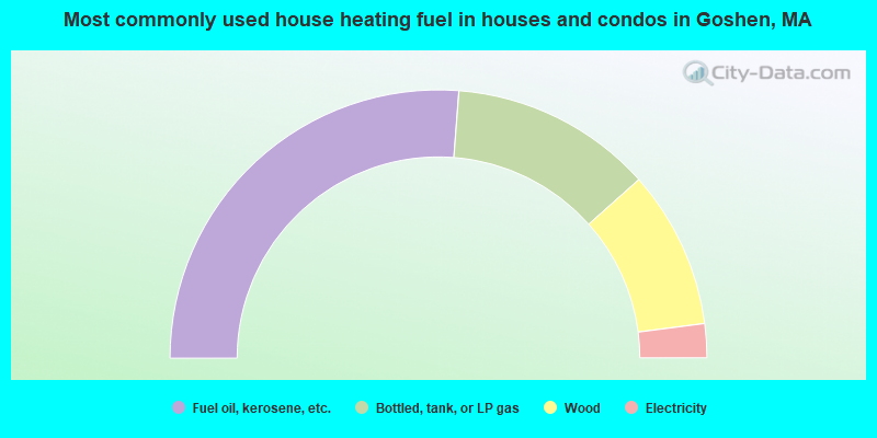
- 52.5%Fuel oil, kerosene, etc.
- 24.4%Bottled, tank, or LP gas
- 19.1%Wood
- 4.1%Electricity
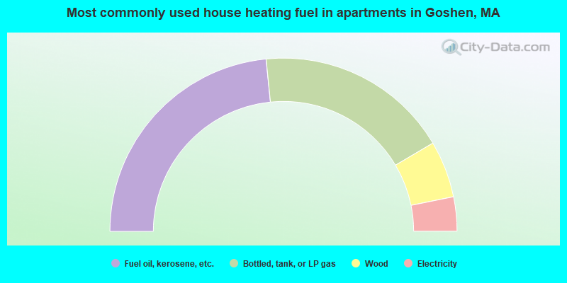
- 46.8%Fuel oil, kerosene, etc.
- 36.2%Bottled, tank, or LP gas
- 10.6%Wood
- 6.4%Electricity
Goshen compared to Massachusetts state average:
- Unemployed percentage significantly below state average.
- Black race population percentage significantly below state average.
- Hispanic race population percentage significantly below state average.
- Median age above state average.
- Foreign-born population percentage significantly below state average.
- Renting percentage significantly below state average.
- Length of stay since moving in significantly above state average.
- Number of rooms per house significantly below state average.
- House age significantly below state average.

|
Total of 1 patent application in 2008-2024.