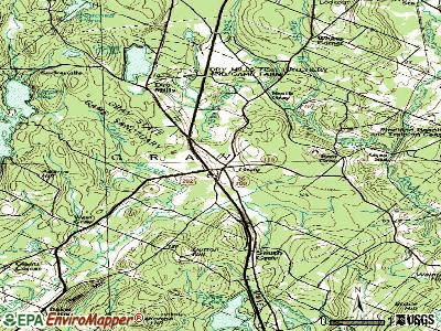
Gray, Maine

Gray: Sunrise Gray Center. Junction of RT26 and RT100

Gray: Town Hall Gray Maine

Gray: North Yarmouth Snow
- add
your
Submit your own pictures of this town and show them to the world
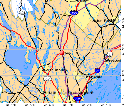
- OSM Map
- General Map
- Google Map
- MSN Map
Population change since 2000: +13.8%
 |
| Males: 3,857 | |
| Females: 3,904 |
| Median resident age: | 40.6 years |
| Maine median age: | 43.0 years |
Zip codes: 04039.
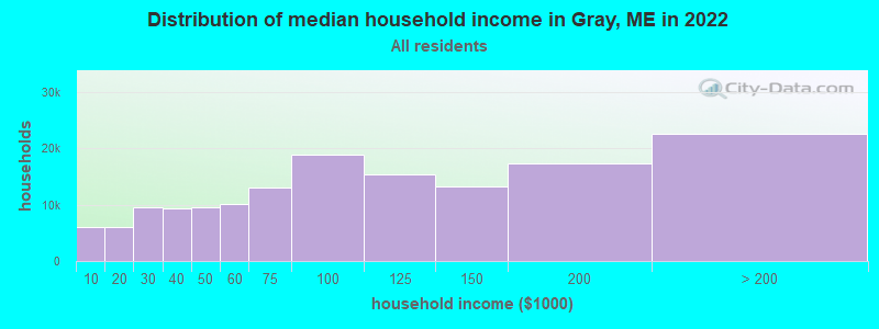
| Gray: | $101,635 |
| ME: | $69,543 |
Estimated per capita income in 2022: $50,702 (it was $22,050 in 2000)
Gray town income, earnings, and wages data
Estimated median house or condo value in 2022: $415,040 (it was $121,800 in 2000)
| Gray: | $415,040 |
| ME: | $290,600 |
Mean prices in 2022: all housing units: $514,200; detached houses: $533,395; townhouses or other attached units: $572,947; in 2-unit structures: $538,406; in 3-to-4-unit structures: $462,507; in 5-or-more-unit structures: $450,834; mobile homes: $93,551
Detailed information about poverty and poor residents in Gray, ME
Compare current foreclosures near Gray, ME:
| Photo | Address | Area | Beds / Baths | Price | Details |
|---|---|---|---|---|---|

|
#1
Yarmouth Rd
Gray, ME 04039
|
- sq. feet
|
- baths - beds |
show details | |

|
#2
Hale Rd
Raymond, ME 04071
|
2,808 sq. feet
|
2 baths 3 beds |
$474,900
|
show details |

|
#3
Lattimer Rd
Gray, ME 04039
|
- sq. feet
|
- baths - beds |
show details | |

|
#4
Motorcycle Dr
Windham, ME 04062
|
2,772 sq. feet
|
2 baths 3 beds |
show details | |

|
#5
Pleasant St
Lisbon Falls, ME 04252
|
561 sq. feet
|
1 baths 2 beds |
show details | |

|
#6
Western Promenade
Auburn, ME 04210
|
2,908 sq. feet
|
3 baths 5 beds |
show details | |

|
#7
Cram Rd
East Baldwin, ME 04024
|
982 sq. feet
|
1 baths 2 beds |
show details | |

|
#8
Nottingham Rd
Auburn, ME 04210
|
1,692 sq. feet
|
2 baths 2 beds |
show details | |

|
#9
Spring St
Lisbon, ME 04250
|
1,141 sq. feet
|
1 baths 3 beds |
show details | |

|
#10
Line Rd
Gorham, ME 04038
|
1,086 sq. feet
|
1 baths 3 beds |
show details |
| Photo | Address | Area | Beds / Baths | Price | Details |
|---|---|---|---|---|---|

|
#11
High St
Windham, ME 04062
|
933 sq. feet
|
1 baths 2 beds |
show details | |

|
#12
Bridge St
Westbrook, ME 04092
|
1,268 sq. feet
|
1 baths 2 beds |
show details | |

|
#13
Jennifer Way
Gorham, ME 04038
|
1,414 sq. feet
|
1 baths 3 beds |
show details | |

|
#14
Stevens Mill Rd
Auburn, ME 04210
|
1,547 sq. feet
|
2 baths 4 beds |
show details | |

|
#15
Church St
Westbrook, ME 04092
|
1,529 sq. feet
|
1 baths 3 beds |
show details | |

|
#16
Minot Ave
Auburn, ME 04210
|
1,444 sq. feet
|
1 baths 3 beds |
show details | |

|
#17
Anita Ave
Auburn, ME 04210
|
2,016 sq. feet
|
1 baths 3 beds |
show details | |

|
#18
Pownal Rd
Auburn, ME 04210
|
1,099 sq. feet
|
1 baths 2 beds |
show details | |

|
#19
Saco St Unit 2
Westbrook, ME 04092
|
1,725 sq. feet
|
2 baths 4 beds |
show details | |

|
#20
Goldie Ln
Standish, ME 04084
|
2,273 sq. feet
|
1 baths 3 beds |
show details |
| Photo | Address | Area | Beds / Baths | Price | Details |
|---|---|---|---|---|---|

|
#21
Haskell St
Westbrook, ME 04092
|
1,573 sq. feet
|
1 baths 3 beds |
show details | |

|
#22
Windham Center Rd
Windham, ME 04062
|
1,576 sq. feet
|
1 baths 3 beds |
show details | |

|
#23
Bruce Hill Rd
Cumberland Center, ME 04021
|
2,536 sq. feet
|
2 baths 3 beds |
show details | |

|
#24
Running Brook Rd
Windham, ME 04062
|
1,749 sq. feet
|
2 baths 3 beds |
show details | |

|
#25
Ring Landing Rd
Casco, ME 04015
|
1,296 sq. feet
|
1 baths 3 beds |
show details | |

|
#26
Majestic Hts
Windham, ME 04062
|
1,668 sq. feet
|
2 baths 3 beds |
show details | |

|
#27
Cottage Rd
Windham, ME 04062
|
1,404 sq. feet
|
1 baths 2 beds |
show details | |

|
#28
Emerson Dr
Windham, ME 04062
|
1,080 sq. feet
|
1 baths 3 beds |
show details | |

|
#29
Riverside Dr # 650
Auburn, ME 04210
|
- sq. feet
|
- baths - beds |
show details | |

|
#30
India St # 1
Portland, ME 04101
|
- sq. feet
|
- baths - beds |
show details |
| Photo | Address | Area | Beds / Baths | Price | Details |
|---|---|---|---|---|---|

|
#31
Webster Rd
Buxton, ME 04093
|
- sq. feet
|
- baths - beds |
show details | |

|
#32
Congress St
Portland, ME 04101
|
- sq. feet
|
- baths - beds |
show details | |

|
#33
Congress St # 2
Portland, ME 04102
|
- sq. feet
|
- baths - beds |
show details | |

|
#34
Park Ave Apt 2
Portland, ME 04101
|
- sq. feet
|
- baths - beds |
show details | |

|
#35
Emma Ln
Gorham, ME 04038
|
- sq. feet
|
- baths - beds |
show details | |

|
#36
Cumberland Ave # 302
Portland, ME 04101
|
- sq. feet
|
- baths - beds |
show details | |

|
#37
Gray Rd
Cumberland Center, ME 04021
|
- sq. feet
|
- baths - beds |
show details | |

|
#38
Sabattus Creek Dr
Lisbon, ME 04250
|
- sq. feet
|
- baths - beds |
show details | |

|
#39
Congress St Unit 307
Portland, ME 04101
|
- sq. feet
|
- baths - beds |
show details | |

|
#40
Bartlett St
Lewiston, ME 04240
|
- sq. feet
|
- baths - beds |
show details |
| Photo | Address | Area | Beds / Baths | Price | Details |
|---|---|---|---|---|---|

|
#41
Devereaux Cir
South Portland, ME 04106
|
- sq. feet
|
- baths - beds |
show details | |

|
#42
Belmont Ct, Unit 8
Auburn, ME 04210
|
- sq. feet
|
- baths - beds |
show details | |

|
#43
Chase Ct
Freeport, ME 04032
|
- sq. feet
|
- baths - beds |
show details | |

|
#44
Spring St Apt 2
Lewiston, ME 04240
|
- sq. feet
|
- baths - beds |
show details | |

|
#45
Liza Harmon Dr Apt 128
Westbrook, ME 04092
|
- sq. feet
|
- baths - beds |
show details | |

|
#46
Durham Rd
Freeport, ME 04032
|
- sq. feet
|
- baths - beds |
show details | |

|
#47
Liberty Way
Portland, ME 04103
|
- sq. feet
|
- baths - beds |
show details | |

|
#48
Ocean Ave
Portland, ME 04103
|
- sq. feet
|
- baths - beds |
show details | |

|
#49
Lambert St # C2
Portland, ME 04103
|
- sq. feet
|
- baths - beds |
show details | |

|
Check over 1 million property listings on Foreclosure.com!
|
browse all offers | |||


- 7,49196.5%White alone
- 871.1%Two or more races
- 660.9%Hispanic
- 500.6%Black alone
- 380.5%Asian alone
- 180.2%American Indian alone
- 80.1%Other race alone
- 30.04%Native Hawaiian and Other
Pacific Islander alone
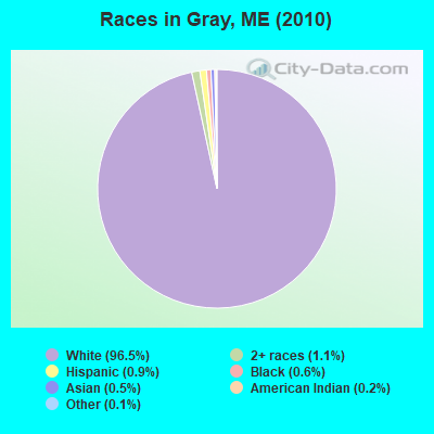
Races in Gray detailed stats: ancestries, foreign born residents, place of birth
According to our research of Maine and other state lists, there were 5 registered sex offenders living in Gray, Maine as of April 25, 2024.
The ratio of all residents to sex offenders in Gray is 1,552 to 1.
The ratio of registered sex offenders to all residents in this city is much lower than the state average.
 Recent articles from our blog. Our writers, many of them Ph.D. graduates or candidates, create easy-to-read articles on a wide variety of topics.

 | Question about Back Cove (10 replies) |
| Moving to ME from Hawaii (10 replies) |
| Will Portland home prices keep going up? (46 replies) |
| Alternative to Cape-Falmouth-Yarmouth-Scarborough-Cumberland WITH good schools? (18 replies) |
| Where do teens get summer jobs in the Portland area? (12 replies) |
| Arundel? (8 replies) |
Latest news from Gray, ME collected exclusively by city-data.com from local newspapers, TV, and radio stations
Gray, ME City Guides:
Ancestries: English (23.5%), Irish (16.1%), French (14.9%), German (9.7%), French Canadian (8.3%), Italian (6.8%).
Current Local Time: EST time zone
Incorporated on 06/19/1778
Elevation: 301 feet
Land area: 43.3 square miles.
Population density: 179 people per square mile (very low).
108 residents are foreign born
| This town: | 1.6% |
| Maine: | 2.9% |
| Gray town: | 1.4% ($1,730) |
| Maine: | 1.5% ($1,417) |
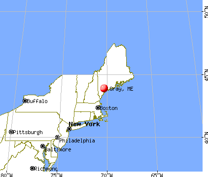
Nearest city with pop. 50,000+: Portland, ME  (15.6 miles , pop. 64,249).
Nearest city with pop. 200,000+: Boston, MA (114.1 miles , pop. 589,141).
Nearest city with pop. 1,000,000+: Bronx, NY (276.3 miles , pop. 1,332,650).
Nearest cities:
), ), ), )Latitude: 43.88 N, Longitude: 70.36 W
Area code: 207

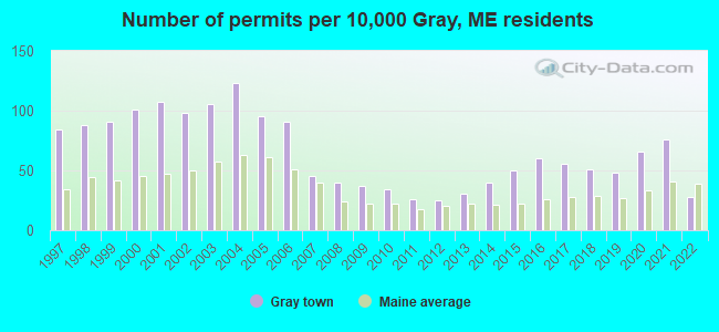
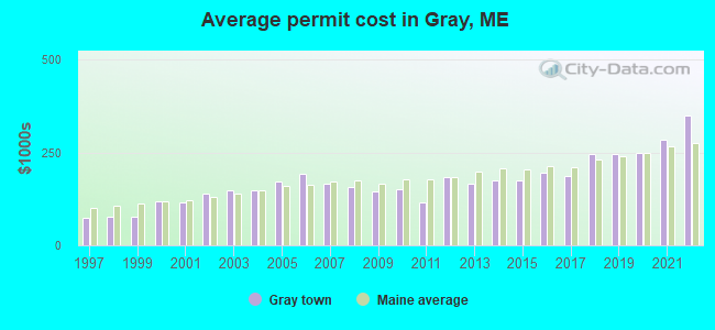
Single-family new house construction building permits:
- 2022: 19 buildings, average cost: $350,400
- 2021: 52 buildings, average cost: $285,800
- 2020: 45 buildings, average cost: $249,600
- 2019: 33 buildings, average cost: $247,100
- 2018: 35 buildings, average cost: $244,900
- 2017: 38 buildings, average cost: $185,800
- 2016: 41 buildings, average cost: $197,400
- 2015: 34 buildings, average cost: $176,200
- 2014: 27 buildings, average cost: $174,400
- 2013: 21 buildings, average cost: $165,200
- 2012: 17 buildings, average cost: $183,500
- 2011: 18 buildings, average cost: $116,100
- 2010: 23 buildings, average cost: $149,700
- 2009: 25 buildings, average cost: $145,400
- 2008: 27 buildings, average cost: $158,000
- 2007: 31 buildings, average cost: $165,800
- 2006: 62 buildings, average cost: $194,200
- 2005: 65 buildings, average cost: $171,100
- 2004: 84 buildings, average cost: $149,400
- 2003: 72 buildings, average cost: $148,000
- 2002: 67 buildings, average cost: $138,100
- 2001: 73 buildings, average cost: $116,100
- 2000: 69 buildings, average cost: $118,000
- 1999: 62 buildings, average cost: $76,400
- 1998: 60 buildings, average cost: $76,800
- 1997: 57 buildings, average cost: $75,200
| Here: | 2.7% |
| Maine: | 3.4% |
- Finance & insurance (8.3%)
- Health care (8.2%)
- Accommodation & food services (7.1%)
- Educational services (5.4%)
- Construction (5.2%)
- Professional, scientific, technical services (4.9%)
- Administrative & support & waste management services (4.7%)
- Construction (9.7%)
- Accommodation & food services (6.0%)
- Professional, scientific, technical services (5.0%)
- Educational services (4.6%)
- Motor vehicle & parts dealers (4.6%)
- Administrative & support & waste management services (4.5%)
- Public administration (3.9%)
- Finance & insurance (16.4%)
- Health care (14.2%)
- Accommodation & food services (8.3%)
- Social assistance (8.1%)
- Educational services (6.4%)
- Administrative & support & waste management services (4.9%)
- Professional, scientific, technical services (4.8%)

- Other office and administrative support workers, including supervisors (4.6%)
- Material recording, scheduling, dispatching, and distributing workers (4.4%)
- Other management occupations, except farmers and farm managers (4.3%)
- Sales representatives, services, wholesale and manufacturing (4.3%)
- Other production occupations, including supervisors (3.9%)
- Cooks and food preparation workers (3.5%)
- Driver/sales workers and truck drivers (3.2%)
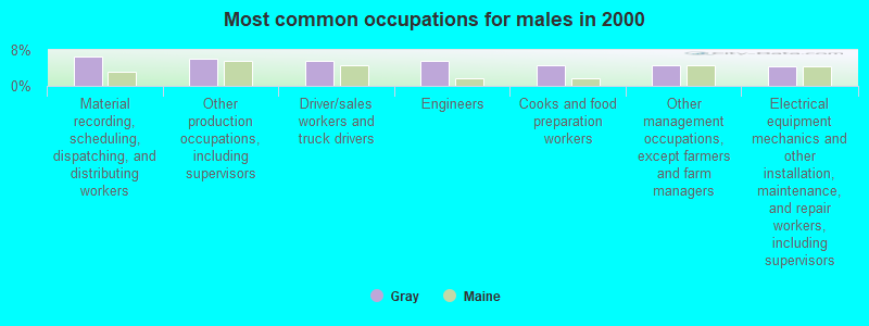
- Material recording, scheduling, dispatching, and distributing workers (6.7%)
- Other production occupations, including supervisors (6.1%)
- Driver/sales workers and truck drivers (5.7%)
- Engineers (5.5%)
- Cooks and food preparation workers (4.6%)
- Other management occupations, except farmers and farm managers (4.5%)
- Electrical equipment mechanics and other installation, maintenance, and repair workers, including supervisors (4.3%)

- Other office and administrative support workers, including supervisors (9.2%)
- Secretaries and administrative assistants (4.9%)
- Sales representatives, services, wholesale and manufacturing (4.7%)
- Bookkeeping, accounting, and auditing clerks (4.5%)
- Child care workers (4.4%)
- Registered nurses (4.3%)
- Other management occupations, except farmers and farm managers (4.0%)
Average climate in Gray, Maine
Based on data reported by over 4,000 weather stations


(lower is better)
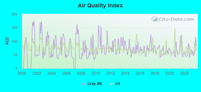
Air Quality Index (AQI) level in 2023 was 69.3. This is about average.
| City: | 69.3 |
| U.S.: | 72.6 |
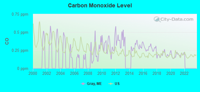
Carbon Monoxide (CO) [ppm] level in 2021 was 0.192. This is better than average. Closest monitor was 15.9 miles away from the city center.
| City: | 0.192 |
| U.S.: | 0.251 |
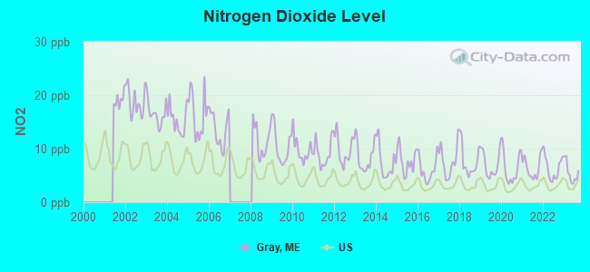
Nitrogen Dioxide (NO2) [ppb] level in 2023 was 5.47. This is about average. Closest monitor was 15.9 miles away from the city center.
| City: | 5.47 |
| U.S.: | 5.11 |
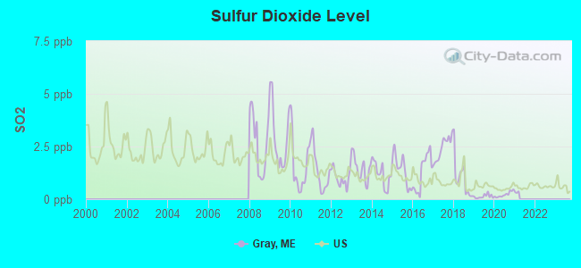
Sulfur Dioxide (SO2) [ppb] level in 2020 was 0.222. This is significantly better than average. Closest monitor was 10.9 miles away from the city center.
| City: | 0.222 |
| U.S.: | 1.515 |
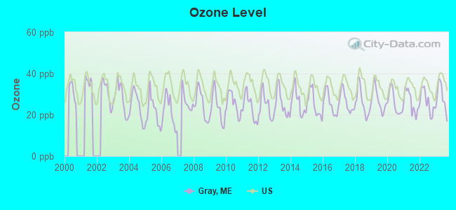
Ozone [ppb] level in 2023 was 28.4. This is about average. Closest monitor was 6.5 miles away from the city center.
| City: | 28.4 |
| U.S.: | 33.3 |
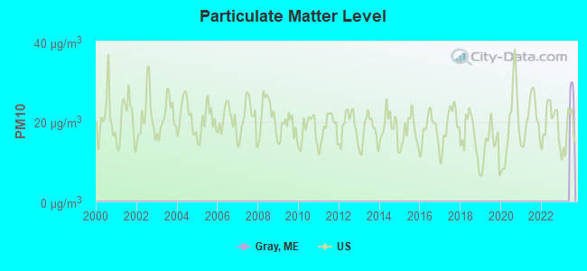
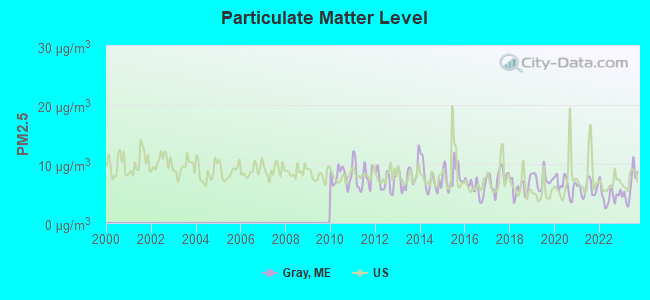
Particulate Matter (PM2.5) [µg/m3] level in 2023 was 6.19. This is better than average. Closest monitor was 14.2 miles away from the city center.
| City: | 6.19 |
| U.S.: | 8.11 |
Tornado activity:
Gray-area historical tornado activity is above Maine state average. It is 78% smaller than the overall U.S. average.
On 7/8/1996, a category F2 (max. wind speeds 113-157 mph) tornado 28.8 miles away from the Gray town center caused $10,000 in damages.
On 7/31/1971, a category F2 tornado 35.0 miles away from the town center caused between $50,000 and $500,000 in damages.
Earthquake activity:
Gray-area historical earthquake activity is significantly above Maine state average. It is 75% smaller than the overall U.S. average.On 10/16/2012 at 23:12:25, a magnitude 4.7 (4.7 ML, Depth: 10.0 mi, Class: Light, Intensity: IV - V) earthquake occurred 24.8 miles away from the city center
On 4/20/2002 at 10:50:47, a magnitude 5.3 (5.3 ML, Depth: 3.0 mi, Class: Moderate, Intensity: VI - VII) earthquake occurred 171.3 miles away from Gray center
On 4/20/2002 at 10:50:47, a magnitude 5.2 (5.2 MB, 4.2 MS, 5.2 MW, 5.0 MW) earthquake occurred 171.9 miles away from the city center
On 1/19/1982 at 00:14:42, a magnitude 4.7 (4.5 MB, 4.7 MD, 4.5 LG) earthquake occurred 67.6 miles away from Gray center
On 10/7/1983 at 10:18:46, a magnitude 5.3 (5.1 MB, 5.3 LG, 5.1 ML) earthquake occurred 198.7 miles away from Gray center
On 8/21/1996 at 07:54:14, a magnitude 3.8 (3.8 LG, 3.6 LG, Depth: 6.2 mi, Class: Light, Intensity: II - III) earthquake occurred 53.8 miles away from the city center
Magnitude types: regional Lg-wave magnitude (LG), body-wave magnitude (MB), duration magnitude (MD), local magnitude (ML), surface-wave magnitude (MS), moment magnitude (MW)
Natural disasters:
The number of natural disasters in Cumberland County (33) is a lot greater than the US average (15).Major Disasters (Presidential) Declared: 22
Emergencies Declared: 10
Causes of natural disasters: Floods: 19, Storms: 13, Snows: 7, Winter Storms: 6, Heavy Rains: 3, Hurricanes: 3, Winds: 3, Blizzard: 1, Ice Storm: 1, Mudslide: 1, Snowfall: 1, Snowstorm: 1, Tornado: 1, Other: 2 (Note: some incidents may be assigned to more than one category).
Hospitals and medical centers near Gray:
- BRENTWOOD REHAB AND NURSING CENTER (Nursing Home, about 11 miles away; YARMOUTH, ME)
- SEDGEWOOD COMMONS (Nursing Home, about 13 miles away; FALMOUTH, ME)
- FALMOUTH BY THE SEA (Nursing Home, about 13 miles away; FALMOUTH, ME)
- FREEPORT NURSING AND REHAB CENTER (Nursing Home, about 13 miles away; FREEPORT, ME)
- WESTBROOK COMMUNITY HOSPITAL (Hospital, about 14 miles away; WESTBROOK, ME)
- ST JOSEPH'S REHABILITATION AND RESIDENCE (Nursing Home, about 14 miles away; PORTLAND, ME)
- CASCO BAY DIALYSIS FACILITY (Dialysis Facility, about 14 miles away; WESTBROOK, ME)
located in Gray:
Colleges/universities with over 2000 students nearest to Gray:
- Saint Joseph's College of Maine (about 8 miles; Standish, ME; Full-time enrollment: 2,010)
- University of Southern Maine (about 16 miles; Portland, ME; FT enrollment: 6,647)
- Southern Maine Community College (about 18 miles; South Portland, ME; FT enrollment: 4,666)
- University of New England (about 30 miles; Biddeford, ME; FT enrollment: 4,539)
- University of Maine at Augusta (about 42 miles; Augusta, ME; FT enrollment: 3,204)
- University of Maine at Farmington (about 56 miles; Farmington, ME; FT enrollment: 2,036)
- University of New Hampshire-Main Campus (about 60 miles; Durham, NH; FT enrollment: 15,243)
Public high school in Gray:
- GRAY-NEW GLOUCESTER HIGH SCHOOL (Location: 10 LIBBY HILL ROAD, Grades: 9-12)
Public elementary/middle schools in Gray:
- RUSSELL SCHOOL (Location: 8 GRAY PARK, Grades: KG-2)
- GRAY-NEW GLOUCESTER MIDDLE SCHOOL (Location: 31 LIBBY HILL ROAD, Grades: 5-8)
- FIDDLEHEAD SCHOOL OF ARTS & SCIENCE (Location: NO PHYSICAL LOCATION AVAILABLE, Grades: PK-3, Charter school)
Points of interest:
Notable locations in Gray: Village Fire and Rescue Station (A), Gray Public Library (B). Display/hide their locations on the map
Shopping Center: Gray Plaza Shopping Center (1). Display/hide its location on the map
Swamps: Gray Meadow (A). Display/hide its location on the map
Streams, rivers, and creeks: Wiggins Brook (A). Display/hide its location on the map
Tourist attraction: Amerigo (Tours & Charters; P.O. Box 505).
Hotel: Busy Bee Cabins (272 Portland Road).
Birthplace of: Cuke Barrows - Baseball player, Samuel Mayall - Politician.
Drinking water stations with addresses in Gray and their reported violations in the past:
GRAY WATER DISTRICT (Population served: 2,415, Groundwater):Past monitoring violations:DISANTOS RESTAURANT (Population served: 420, Groundwater):
- One routine major monitoring violation
Past health violations:FRATERNAL ORDER OF EAGLES 4131 (Population served: 300, Groundwater):Past monitoring violations:
- MCL, Monthly (TCR) - In NOV-2013, Contaminant: Coliform. Follow-up actions: St Public Notif requested (NOV-07-2013), St Formal NOV issued (NOV-07-2013), St Public Notif received (NOV-18-2013), St Compliance achieved (DEC-10-2013)
- MCL, Monthly (TCR) - In AUG-2013, Contaminant: Coliform. Follow-up actions: St Public Notif requested (SEP-04-2013), St Formal NOV issued (SEP-04-2013), St Public Notif received (SEP-11-2013), St Compliance achieved (NOV-04-2013)
- MCL, Monthly (TCR) - In JUL-2013, Contaminant: Coliform. Follow-up actions: St Compliance achieved (NOV-04-2013)
- 10 routine major monitoring violations
- One regular monitoring violation
Past monitoring violations:BUSY BEE CABINS (Population served: 250, Groundwater):
- 5 routine major monitoring violations
- 7 regular monitoring violations
Past monitoring violations:RSU 15 MEMORIAL SCHOOL (Population served: 248, Groundwater):
- 13 routine major monitoring violations
- One regular monitoring violation
Past monitoring violations:WILSONDALE COUNTRY CARE (Address: WILSONDALE COUNTRY CARE CHILD CARE CENTE , Population served: 65, Groundwater):
- 2 routine major monitoring violations
Past health violations:
- MCL, Monthly (TCR) - In OCT-2013, Contaminant: Coliform. Follow-up actions: St Public Notif requested (NOV-07-2013), St Formal NOV issued (NOV-07-2013), St Compliance achieved (NOV-18-2013), St Public Notif received (NOV-18-2013)
| This town: | 2.5 people |
| Maine: | 2.3 people |
| This town: | 69.3% |
| Whole state: | 62.9% |
| This town: | 10.4% |
| Whole state: | 9.4% |
Likely homosexual households (counted as self-reported same-sex unmarried-partner households)
- Lesbian couples: 0.8% of all households
- Gay men: 0.5% of all households
| This town: | 2.6% |
| Whole state: | 10.9% |
| This town: | 1.1% |
| Whole state: | 4.1% |
29 people in nursing homes in 2000
6 people in homes for the mentally retarded in 2000
Banks with branches in Gray (2011 data):
- TD Bank, National Association: Gray Branch at 23 Portland Road, branch established on 1915/01/01. Info updated 2010/10/04: Bank assets: $188,912.6 mil, Deposits: $153,149.8 mil, headquarters in Wilmington, DE, positive income, 1314 total offices, Holding Company: Toronto-Dominion Bank, The
- Androscoggin Savings Bank: Gray Branch at 24 Portland Road, branch established on 1998/05/18. Info updated 2008/07/01: Bank assets: $707.2 mil, Deposits: $506.9 mil, headquarters in Lewiston, ME, positive income, Commercial Lending Specialization, 13 total offices, Holding Company: Androscoggin Bancorp, Mhc
- KeyBank National Association: Gray Branch at 25 Portland Road, branch established on 1974/09/16. Info updated 2008/03/03: Bank assets: $86,198.8 mil, Deposits: $64,214.8 mil, headquarters in Cleveland, OH, positive income, Commercial Lending Specialization, 1067 total offices, Holding Company: Keycorp
For population 15 years and over in Gray:
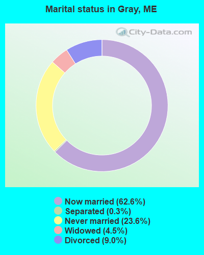
- Never married: 23.6%
- Now married: 62.6%
- Separated: 0.3%
- Widowed: 4.5%
- Divorced: 9.0%
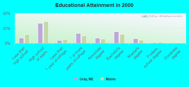
For population 25 years and over in Gray:
- High school or higher: 91.2%
- Bachelor's degree or higher: 28.0%
- Graduate or professional degree: 8.6%
- Unemployed: 1.7%
- Mean travel time to work (commute): 26.7 minutes
| Here: | 9.4 |
| Maine average: | 11.2 |
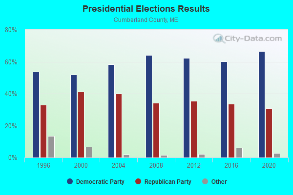
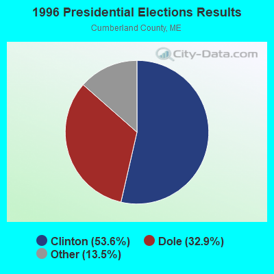
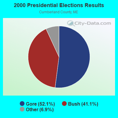
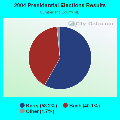

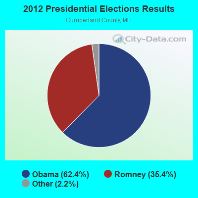
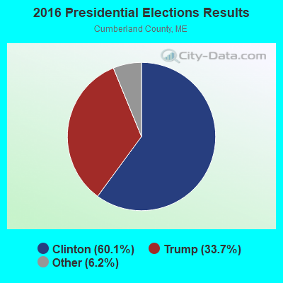
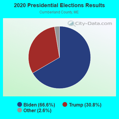
Graphs represent county-level data. Detailed 2008 Election Results
Religion statistics for Gray, ME (based on Cumberland County data)
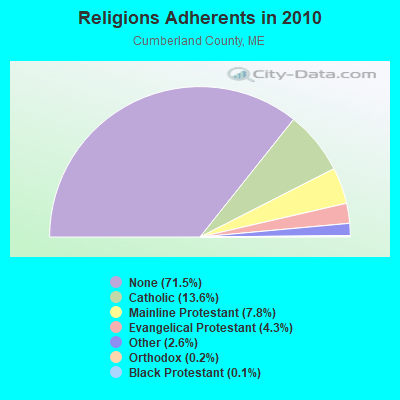
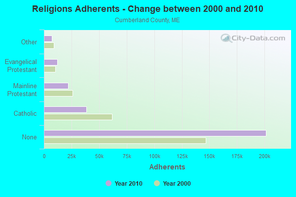
| Religion | Adherents | Congregations |
|---|---|---|
| Catholic | 38,243 | 19 |
| Mainline Protestant | 22,030 | 96 |
| Evangelical Protestant | 12,007 | 85 |
| Other | 7,187 | 44 |
| Orthodox | 500 | 1 |
| Black Protestant | 285 | 2 |
| None | 201,422 | - |
Food Environment Statistics:
| Cumberland County: | 2.62 / 10,000 pop. |
| Maine: | 2.80 / 10,000 pop. |
| Cumberland County: | 0.11 / 10,000 pop. |
| State: | 0.14 / 10,000 pop. |
| Cumberland County: | 2.44 / 10,000 pop. |
| Maine: | 2.20 / 10,000 pop. |
| This county: | 3.82 / 10,000 pop. |
| Maine: | 5.75 / 10,000 pop. |
| Cumberland County: | 12.01 / 10,000 pop. |
| State: | 11.02 / 10,000 pop. |
| Here: | 7.1% |
| Maine: | 8.2% |
| This county: | 19.5% |
| State: | 25.0% |
| Businesses in Gray, ME | ||||
| Name | Count | Name | Count | |
|---|---|---|---|---|
| Ace Hardware | 1 | McDonald's | 1 | |
| Curves | 1 | Rite Aid | 1 | |
| Dunkin Donuts | 1 | Starbucks | 1 | |
| FedEx | 1 | Subway | 1 | |
| GNC | 1 | True Value | 1 | |
| Kincaid | 1 | |||
Strongest AM radio stations in Gray:
- WGAN (560 AM; 5 kW; PORTLAND, ME; Owner: SAGA COMMUNICATIONS OF NEW ENGLAND, LLC)
- WMTW (870 AM; 10 kW; GORHAM, ME; Owner: RADIO PARTNERS OF MAINE, L.P.)
- WLOB (1310 AM; 5 kW; PORTLAND, ME; Owner: ATLANTIC COAST RADIO, LLC)
- WLAM (1470 AM; 5 kW; LEWISTON, ME; Owner: RADIO PARTNERS OF MAINE, L.P.)
- WJAE (1440 AM; 5 kW; WESTBROOK, ME; Owner: ALTANTIC COAST RADIO, LLC)
- WZAN (970 AM; 5 kW; PORTLAND, ME; Owner: SAGA COMMUNICATIONS OF NEW ENGLAND, LLC)
- WRKO (680 AM; 50 kW; BOSTON, MA; Owner: ENTERCOM BOSTON LICENSE, LLC)
- WTME (780 AM; 10 kW; RUMFORD, ME; Owner: MOUNTAIN VALLEY BROADCASTING, INC.)
- WGIN (930 AM; 10 kW; ROCHESTER, NH; Owner: CAPSTAR TX LIMITED PARTNERSHIP)
- WEEI (850 AM; 50 kW; BOSTON, MA; Owner: ENTERCOM BOSTON LICENSE, LLC)
- WBZ (1030 AM; 50 kW; BOSTON, MA; Owner: INFINITY BROADCASTING OPERATIONS, INC.)
- WJJB (900 AM; 1 kW; BRUNSWICK, ME; Owner: ATLANTIC COAST RADIO, LLC)
- WCRN (830 AM; 50 kW; WORCESTER, MA; Owner: CARTER BROADCASTING CORPORATION)
Strongest FM radio stations in Gray:
- WJBQ (97.9 FM; PORTLAND, ME; Owner: CITADEL BROADCASTING COMPANY)
- WMTW-FM (106.7 FM; NORTH WINDHAM, ME; Owner: RADIO PARTNERS OF MAINE, L.P.)
- WBLM (102.9 FM; PORTLAND, ME; Owner: CITADEL BROADCASTING COMPANY)
- WTHT (107.5 FM; LEWISTON, ME; Owner: RADIO PARTNERS OF MAINE, L.P.)
- WMEK-FM (99.9 FM; AUBURN, ME; Owner: RADIO PARTNERS OF MAINE, L.P.)
- WMEA (90.1 FM; PORTLAND, ME; Owner: MAINE PUBLIC BROADCASTING CORPORATION)
- WPOR (101.9 FM; PORTLAND, ME; Owner: SAGA COMMUNICATIONS OF NEW ENGLAND, LLC)
- WMSJ (89.3 FM; FREEPORT, ME; Owner: DOWNEAST CHRISTIAN COMMUNICATIONS)
- WPKQ (103.7 FM; NORTH CONWAY, NH; Owner: CITADEL BROADCASTING COMPANY)
- WHOM (94.9 FM; MT. WASHINGTON, NH; Owner: CITADEL BROADCASTING COMPANY)
- WMGX (93.1 FM; PORTLAND, ME; Owner: SAGA COMMUNICATIONS OF NEW ENGLAND, LLC)
- WSCY (106.9 FM; MOULTONBOROUGH, NH; Owner: NORTHEAST COMMUNICATIONS CORPORATION)
- WJJB-FM (95.5 FM; TOPSHAM, ME; Owner: ATLANTIC COAST RADIO, LLC)
- WCLZ (98.9 FM; BRUNSWICK, ME; Owner: CITADEL BROADCASTING COMPANY)
- WCYI (93.9 FM; LEWISTON, ME; Owner: CITADEL BROADCASTING COMPANY)
- WVFM (105.7 FM; CAMPTON, NH; Owner: DEVON BROADCASTING COMPANY, INC.)
- WYNZ (100.9 FM; WESTBROOK, ME; Owner: SAGA COMMUNICATIONS OF NEW ENGLAND, LLC)
- WLOB-FM (96.3 FM; RUMFORD, ME; Owner: ATLANTIC COAST RADIO, LLC)
- WCYY (94.3 FM; BIDDEFORD, ME; Owner: CITADEL BROADCASTING COMPANY)
- WTBM (100.7 FM; MEXICO, ME; Owner: MOUNTAIN VALLEY BROADCASTING, INC.)
TV broadcast stations around Gray:
- WPXT (Channel 51; PORTLAND, ME; Owner: HMW, INC.)
- WPME (Channel 35; LEWISTON, ME; Owner: KB PRIME MEDIA LLC)
- W32CA (Channel 32; PORTLAND, ME; Owner: NATIONAL MINORITY T.V., INC.)
- WGME-TV (Channel 13; PORTLAND, ME; Owner: WGME LICENSEE, LLC)
- WMTW-TV (Channel 8; POLAND SPRING, ME; Owner: WMTW BROADCAST GROUP, LLC)
- WCSH (Channel 6; PORTLAND, ME; Owner: PACIFIC AND SOUTHERN COMPANY, INC.)
- W58CM (Channel 58; BANGOR, ME; Owner: MS COMMUNICATIONS, LLC)
- WMEA-TV (Channel 26; BIDDEFORD, ME; Owner: MAINE PUBLIC BROADCASTING CORP.)
- W57AP (Channel 57; FALMOUTH, ME; Owner: SHERWOOD H. CRAIG)
- WPFO (Channel 23; WATERVILLE, ME; Owner: CMCG PORTLAND LICENSE LLC)
- WCBB (Channel 10; AUGUSTA, ME; Owner: MAINE PUBLIC BROADCASTING CORP.)
- WLLB-LP (Channel 15; PORTLAND, ME; Owner: CARTER BROADCASTING CORPORATION)
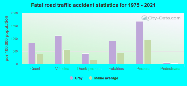
- National Bridge Inventory (NBI) Statistics
- 12Number of bridges
- 72ft / 21.8mTotal length
- 1,468,611Total average daily traffic
- 73,430Total average daily truck traffic
- 94,524Total future (year 2036) average daily traffic
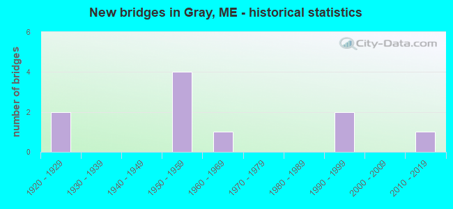
- New bridges - historical statistics
- 21920-1929
- 41950-1959
- 11960-1969
- 21990-1999
- 12010-2019
FCC Registered Cell Phone Towers:
3 (See the full list of FCC Registered Cell Phone Towers in Gray)FCC Registered Antenna Towers:
67 (See the full list of FCC Registered Antenna Towers)FCC Registered Commercial Land Mobile Towers:
2 (See the full list of FCC Registered Commercial Land Mobile Towers in Gray, ME)FCC Registered Broadcast Land Mobile Towers:
15 (See the full list of FCC Registered Broadcast Land Mobile Towers)FCC Registered Microwave Towers:
14 (See the full list of FCC Registered Microwave Towers in this town)FCC Registered Paging Towers:
3 (See the full list of FCC Registered Paging Towers)FCC Registered Amateur Radio Licenses:
45 (See the full list of FCC Registered Amateur Radio Licenses in Gray)FAA Registered Aircraft:
2- Aircraft: CESSNA 180K (Category: Land, Seats: 4, Weight: Up to 12,499 Pounds, Speed: 114 mph), Engine: CONT MOTOR O-470 SERIES (230 HP) (Reciprocating)
N-Number: 4815, N4815, N-4815, Serial Number: 18053056, Year manufactured: 1979, Airworthiness Date: 09/10/1996, Certificate Issue Date: 09/14/2006
Registrant (LLC): Kbj LLC, 30 Fran Cir, Gray, ME 04039 - Aircraft: CESSNA 152 (Category: Land, Seats: 2, Weight: Up to 12,499 Pounds), Engine: LYCOMING 0-235 SERIES (115 HP) (4 Cycle)
N-Number: 94963, N94963, N-94963, Serial Number: 15285825, Airworthiness Date: 08/23/1983, Certificate Issue Date: 02/04/2020
Registrant (LLC): Twin Cities Air Service LLC, Po Box 2, Gray, ME 04039
Deregistered: Cancel Date: 11/04/2019
2003 - 2018 National Fire Incident Reporting System (NFIRS) incidents
- Fire incident types reported to NFIRS in Gray, ME
- 22557.1%Structure Fires
- 10025.4%Outside Fires
- 6015.2%Mobile Property/Vehicle Fires
- 92.3%Other
 According to the data from the years 2003 - 2018 the average number of fire incidents per year is 25. The highest number of fires - 52 took place in 2017, and the least - 3 in 2007. The data has an increasing trend.
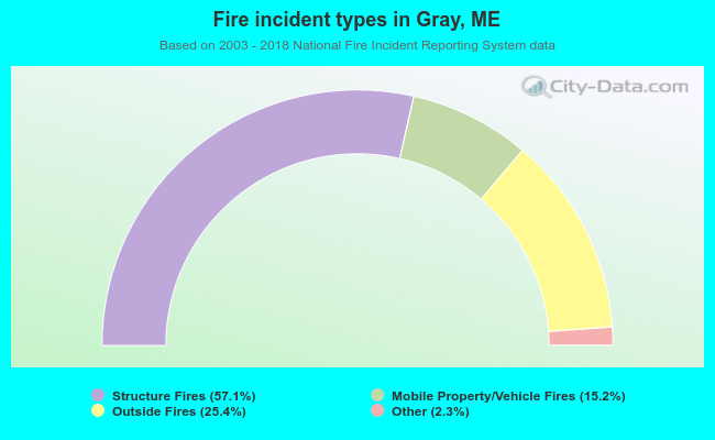 When looking into fire subcategories, the most reports belonged to: Structure Fires (57.1%), and Outside Fires (25.4%).
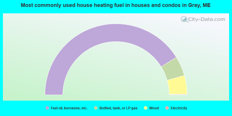
- 82.3%Fuel oil, kerosene, etc.
- 8.9%Bottled, tank, or LP gas
- 8.5%Wood
- 0.3%Electricity
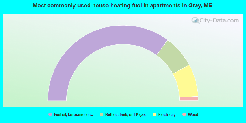
- 70.3%Fuel oil, kerosene, etc.
- 14.1%Bottled, tank, or LP gas
- 13.9%Electricity
- 1.8%Wood
Gray compared to Maine state average:
- Unemployed percentage significantly below state average.
- Black race population percentage below state average.
- Hispanic race population percentage below state average.
- Foreign-born population percentage significantly below state average.
- Length of stay since moving in significantly above state average.
- Number of rooms per house significantly below state average.
- House age significantly below state average.
Gray on our top lists:
- #9 on the list of "Top 101 cities with largest percentage of males in industries: u. s. postal service (population 5,000+)"
- #10 on the list of "Top 101 cities with largest percentage of males in industries: drugs, sundries, and chemical and allied products merchant wholesalers (population 5,000+)"
- #13 on the list of "Top 101 cities with largest percentage of males in industries: electronic shopping and mail-order houses (population 5,000+)"
- #13 on the list of "Top 101 cities with largest percentage of females in occupations: business operations specialists (population 5,000+)"
- #13 on the list of "Top 101 cities with largest percentage of females in occupations: architects, surveyors, and cartographers (population 5,000+)"
- #16 on the list of "Top 101 cities with largest percentage of males in occupations: cooks and food preparation workers (population 5,000+)"
- #17 on the list of "Top 101 cities with largest percentage of males in occupations: material recording, scheduling, dispatching, and distributing workers (population 5,000+)"
- #17 on the list of "Top 101 cities with largest percentage of males in industries: groceries and related products merchant wholesalers (population 5,000+)"
- #20 on the list of "Top 101 cities with largest percentage of females in occupations: sales representatives, services, wholesale and manufacturing (population 5,000+)"
- #25 on the list of "Top 101 cities with largest percentage of males in occupations: bus drivers (population 5,000+)"
- #25 on the list of "Top 101 cities with largest percentage of females in industries: lumber and other construction materials merchant wholesalers (population 5,000+)"
- #28 on the list of "Top 101 cities with largest percentage of females in industries: electronic shopping and mail-order houses (population 5,000+)"
- #28 on the list of "Top 101 cities with largest percentage of females in industries: motor vehicles, parts and supplies merchant wholesalers (population 5,000+)"
- #29 on the list of "Top 101 cities with largest percentage of females in industries: social assistance (population 5,000+)"
- #32 on the list of "Top 101 cities with largest percentage of males in industries: used merchandise, gift, novelty, and souvenir, and other miscellaneous stores (population 5,000+)"
- #41 on the list of "Top 101 cities with largest percentage of males in industries: motor vehicle and parts dealers (population 5,000+)"
- #42 on the list of "Top 101 cities with largest percentage of males in industries: fuel dealers (population 5,000+)"
- #45 on the list of "Top 101 cities with largest percentage of males in industries: health and personal care, except drug, stores (population 5,000+)"
- #55 on the list of "Top 101 cities with largest percentage of females in industries: leather and allied products (population 5,000+)"
- #57 on the list of "Top 101 cities with largest percentage of females in industries: furniture and home furnishing merchant wholesalers (population 5,000+)"
- #28 on the list of "Top 101 counties with the highest percentage of residents that exercised in the past month"
- #30 on the list of "Top 101 counties with the best general health status score of residents (1-5), 3 years of data"
- #40 on the list of "Top 101 counties with the highest percentage of residents that visited a dentist within the past year"
- #43 on the list of "Top 101 counties with the highest Nitrogen Dioxide air pollution readings in 2012 (ppm)"
- #49 on the list of "Top 101 counties with the lowest number of births per 1000 residents 2007-2013"

|
|
Total of 52 patent applications in 2008-2024.