Jack, Alabama
Submit your own pictures of this place and show them to the world
- OSM Map
- General Map
- Google Map
- MSN Map

| Males: 970 | |
| Females: 983 |
| Median resident age: | 36.9 years |
| Alabama median age: | 35.8 years |
Zip code: 36323
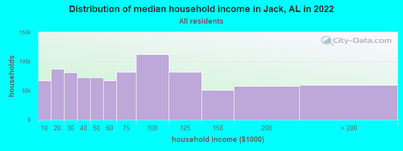
| Jack: | $55,902 |
| AL: | $59,674 |
Estimated per capita income in 2022: $22,280 (it was $12,904 in 2000)
Jack CCD income, earnings, and wages data
Estimated median house or condo value in 2022: $115,918 (it was $44,800 in 2000)
| Jack: | $115,918 |
| AL: | $200,900 |
Detailed information about poverty and poor residents in Jack, AL
Compare current foreclosures near Jack, AL:
| Photo | Address | Area | Beds / Baths | Price | Details |
|---|---|---|---|---|---|

|
#1
County Road 110
Jack, AL 36346
|
1,251 sq. feet
|
1 baths - beds |
show details | |

|
#2
County Road 205
Jack, AL 36346
|
- sq. feet
|
- baths - beds |
show details | |

|
#3
County Road 200
Jack, AL 36346
|
- sq. feet
|
- baths - beds |
show details | |

|
#4
County Road 318
Jack, AL 36346
|
- sq. feet
|
- baths - beds |
show details | |

|
#5
Hwy 87
Jack, AL 36346
|
- sq. feet
|
- baths - beds |
show details | |

|
#6
County Road 114
Jack, AL 36346
|
- sq. feet
|
- baths - beds |
show details | |

|
#7
Highway 87
Jack, AL 36346
|
- sq. feet
|
- baths - beds |
show details | |

|
#8
County Road 119
Jack, AL 36346
|
- sq. feet
|
- baths - beds |
show details | |

|
#9
County Road 209
Jack, AL 36346
|
- sq. feet
|
- baths - beds |
show details | |

|
#10
Settlement Rd
Dozier, AL 36028
|
1,526 sq. feet
|
2 baths 4 beds |
$20,500
|
show details |
| Photo | Address | Area | Beds / Baths | Price | Details |
|---|---|---|---|---|---|

|
#11
Taylor Ave
Elba, AL 36323
|
1,549 sq. feet
|
2 baths 2 beds |
$31,750
|
show details |

|
#12
County Road 119
Jack, AL 36346
|
- sq. feet
|
- baths - beds |
show details | |

|
#13
Highway 87
Jack, AL 36346
|
- sq. feet
|
- baths - beds |
show details | |

|
#14
County Road 110
Jack, AL 36346
|
- sq. feet
|
- baths - beds |
show details | |

|
#15
Highway 189
Elba, AL 36323
|
1,076 sq. feet
|
2 baths 4 beds |
show details | |

|
#16
County Road 315
Elba, AL 36323
|
900 sq. feet
|
1 baths 2 beds |
show details | |

|
#17
County Road 3336
Brundidge, AL 36010
|
1,938 sq. feet
|
2 baths 3 beds |
show details | |

|
#18
County Road 3304
Troy, AL 36079
|
1,824 sq. feet
|
1 baths - beds |
show details | |

|
#19
Forest Ave
Elba, AL 36323
|
1,569 sq. feet
|
2 baths - beds |
show details | |

|
#20
N Watkins St
New Brockton, AL 36351
|
1,272 sq. feet
|
1 baths - beds |
show details |
| Photo | Address | Area | Beds / Baths | Price | Details |
|---|---|---|---|---|---|

|
#21
Oak Bluff Dr
Enterprise, AL 36330
|
2,430 sq. feet
|
1 baths - beds |
show details | |

|
#22
Highway 87
Troy, AL 36079
|
2,814 sq. feet
|
1 baths - beds |
show details | |

|
#23
County Road 409
Elba, AL 36323
|
1,848 sq. feet
|
1 baths - beds |
show details | |

|
#24
Private Road 1206
New Brockton, AL 36351
|
1,873 sq. feet
|
2 baths - beds |
show details | |

|
#25
County Road 219
Elba, AL 36323
|
2,027 sq. feet
|
1 baths - beds |
show details | |

|
#26
Claxton Ave N
Elba, AL 36323
|
2,246 sq. feet
|
1 baths - beds |
show details | |

|
#27
Deer Run Strut
Enterprise, AL 36330
|
1,306 sq. feet
|
1 baths - beds |
show details | |

|
#28
County Road 276
Enterprise, AL 36330
|
1,705 sq. feet
|
1 baths - beds |
show details | |

|
#29
Prospect Ridge Rd
Troy, AL 36079
|
- sq. feet
|
- baths - beds |
show details | |

|
#30
Allison Ave
Troy, AL 36079
|
- sq. feet
|
- baths - beds |
show details |
| Photo | Address | Area | Beds / Baths | Price | Details |
|---|---|---|---|---|---|

|
#31
Ashley Ave
Troy, AL 36079
|
- sq. feet
|
- baths - beds |
show details | |

|
#32
County Road 4431
Brundidge, AL 36010
|
- sq. feet
|
- baths - beds |
show details | |

|
#33
Butler Dr
Troy, AL 36079
|
- sq. feet
|
- baths - beds |
show details | |

|
#34
Whitetail Way
Troy, AL 36079
|
- sq. feet
|
- baths - beds |
show details | |

|
#35
Kelsey Ln
Troy, AL 36079
|
- sq. feet
|
- baths - beds |
show details | |

|
#36
Deer Stand Hill Trl
Troy, AL 36079
|
- sq. feet
|
- baths - beds |
show details | |

|
#37
Highway 87
Elba, AL 36323
|
- sq. feet
|
- baths - beds |
show details | |

|
#38
Enzor Dr # 6
Troy, AL 36079
|
- sq. feet
|
- baths - beds |
show details | |

|
#39
Henderson Hwy
Troy, AL 36079
|
- sq. feet
|
- baths - beds |
show details | |

|
#40
County Road 4435
Brundidge, AL 36010
|
- sq. feet
|
- baths - beds |
show details |
| Photo | Address | Area | Beds / Baths | Price | Details |
|---|---|---|---|---|---|

|
#41
County Road 325
Troy, AL 36079
|
- sq. feet
|
- baths - beds |
show details | |

|
#42
Henderson Hwy
Troy, AL 36079
|
1,260 sq. feet
|
- baths - beds |
show details | |

|
#43
Us Highway 231
Brundidge, AL 36010
|
1,997 sq. feet
|
- baths - beds |
show details | |

|
#44
Spradley Dr
Troy, AL 36079
|
- sq. feet
|
- baths - beds |
show details | |

|
#45
County Road 520
New Brockton, AL 36351
|
- sq. feet
|
- baths - beds |
show details | |

|
#46
Smith Rd
Opp, AL 36467
|
- sq. feet
|
- baths - beds |
show details | |

|
#47
Enzor Rd
Troy, AL 36079
|
1,796 sq. feet
|
- baths - beds |
show details | |

|
#48
Allison Ave
Troy, AL 36079
|
- sq. feet
|
- baths - beds |
show details | |

|
#49
Highway 84
New Brockton, AL 36351
|
- sq. feet
|
- baths - beds |
show details | |

|
Check over 1 million property listings on Foreclosure.com!
|
browse all offers | |||

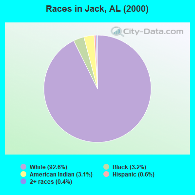
- 1,68292.6%White alone
- 593.2%Black alone
- 563.1%American Indian alone
- 110.6%Hispanic
- 80.4%Two or more races
- 10.06%Asian alone
According to our research of Alabama and other state lists, there were 6 registered sex offenders living in Jack, Alabama as of April 19, 2024.
The ratio of all residents to sex offenders in Jack is 326 to 1.
 Recent articles from our blog. Our writers, many of them Ph.D. graduates or candidates, create easy-to-read articles on a wide variety of topics.
Current Local Time: CST time zone
Elevation: 390 feet
Land area: 93.8 square miles.
Population density: 21 people per square mile (very low).

| Jack CCD: | 0.4% ($199) |
| Alabama: | 0.4% ($289) |
Nearest city with pop. 50,000+: Dothan, AL  (43.8 miles , pop. 57,737).
Nearest city with pop. 200,000+: Montgomery, AL (57.6 miles , pop. 201,568).
Nearest city with pop. 1,000,000+: Houston, TX (569.2 miles , pop. 1,953,631).
Nearest cities:
), ), ), ), ), )Latitude: 31.55 N, Longitude: 86.04 W
Area code commonly used in this area: 334

| Here: | 2.8% |
| Alabama: | 2.6% |
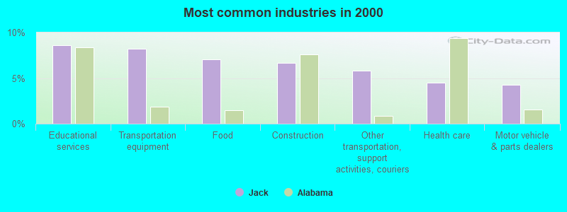
- Educational services (8.6%)
- Transportation equipment (8.2%)
- Food (7.1%)
- Construction (6.7%)
- Other transportation, support activities, couriers (5.8%)
- Health care (4.5%)
- Motor vehicle & parts dealers (4.2%)
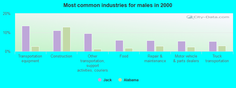
- Transportation equipment (13.5%)
- Construction (11.0%)
- Other transportation, support activities, couriers (9.5%)
- Food (5.9%)
- Repair & maintenance (5.7%)
- Motor vehicle & parts dealers (5.5%)
- Truck transportation (5.3%)
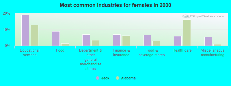
- Educational services (19.0%)
- Food (8.9%)
- Department & other general merchandise stores (6.9%)
- Finance & insurance (6.9%)
- Food & beverage stores (6.6%)
- Health care (5.9%)
- Miscellaneous manufacturing (5.2%)
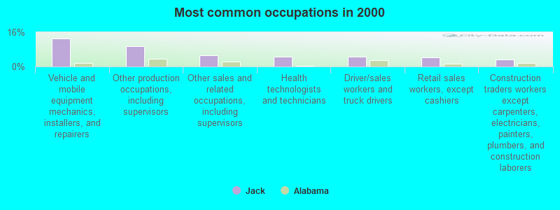
- Vehicle and mobile equipment mechanics, installers, and repairers (13.2%)
- Other production occupations, including supervisors (9.4%)
- Other sales and related occupations, including supervisors (5.1%)
- Health technologists and technicians (4.5%)
- Driver/sales workers and truck drivers (4.5%)
- Retail sales workers, except cashiers (4.2%)
- Construction traders workers except carpenters, electricians, painters, plumbers, and construction laborers (3.3%)
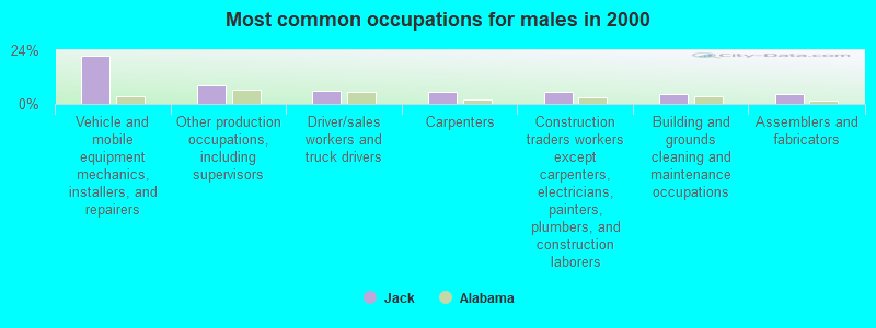
- Vehicle and mobile equipment mechanics, installers, and repairers (21.7%)
- Other production occupations, including supervisors (8.2%)
- Driver/sales workers and truck drivers (6.1%)
- Carpenters (5.5%)
- Construction traders workers except carpenters, electricians, painters, plumbers, and construction laborers (5.5%)
- Building and grounds cleaning and maintenance occupations (4.6%)
- Assemblers and fabricators (4.4%)
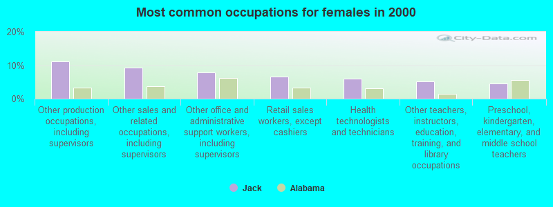
- Other production occupations, including supervisors (11.1%)
- Other sales and related occupations, including supervisors (9.2%)
- Other office and administrative support workers, including supervisors (7.9%)
- Retail sales workers, except cashiers (6.6%)
- Health technologists and technicians (5.9%)
- Other teachers, instructors, education, training, and library occupations (5.2%)
- Preschool, kindergarten, elementary, and middle school teachers (4.6%)
Average climate in Jack, Alabama
Based on data reported by over 4,000 weather stations


(lower is better)
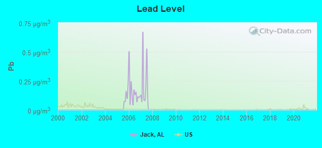
Lead (Pb) [µg/m3] level in 2007 was 0.230. This is significantly worse than average. Closest monitor was 17.0 miles away from the city center.
| City: | 0.230 |
| U.S.: | 0.009 |
Tornado activity:
Jack-area historical tornado activity is slightly below Alabama state average. It is 47% greater than the overall U.S. average.
On 3/1/2007, a category F4 (max. wind speeds 207-260 mph) tornado 20.2 miles away from the Jack place center killed 9 people and injured 50 people and caused $250 million in damages.
On 3/2/1971, a category F3 (max. wind speeds 158-206 mph) tornado 9.8 miles away from the place center caused between $5000 and $50,000 in damages.
Earthquake activity:
Jack-area historical earthquake activity is significantly above Alabama state average. It is 31% greater than the overall U.S. average.On 10/24/1997 at 08:35:17, a magnitude 4.9 (4.8 MB, 4.2 MS, 4.9 LG, Depth: 6.2 mi, Class: Light, Intensity: IV - V) earthquake occurred 78.5 miles away from Jack center
On 1/18/1999 at 07:00:53, a magnitude 4.8 (4.8 MB, 4.0 LG, Depth: 0.6 mi) earthquake occurred 146.3 miles away from Jack center
On 4/29/2003 at 08:59:39, a magnitude 4.9 (4.4 MB, 4.6 MW, 4.9 LG) earthquake occurred 204.8 miles away from Jack center
On 11/7/2004 at 11:20:21, a magnitude 4.3 (4.3 MW, Depth: 3.1 mi) earthquake occurred 134.2 miles away from the city center
On 6/24/1975 at 11:11:36, a magnitude 4.5 (4.5 MB) earthquake occurred 182.7 miles away from the city center
On 4/29/2003 at 08:59:39, a magnitude 4.6 (4.6 MW, Depth: 12.3 mi) earthquake occurred 204.8 miles away from Jack center
Magnitude types: regional Lg-wave magnitude (LG), body-wave magnitude (MB), surface-wave magnitude (MS), moment magnitude (MW)
Natural disasters:
The number of natural disasters in Coffee County (23) is greater than the US average (15).Major Disasters (Presidential) Declared: 15
Emergencies Declared: 6
Causes of natural disasters: Storms: 12, Floods: 9, Hurricanes: 8, Tornadoes: 7, Winds: 4, Drought: 1, Snowfall: 1, Tropical Storm: 1, Winter Storm: 1, Other: 1 (Note: some incidents may be assigned to more than one category).
Airports located in Jack:
- Benedick Airport (AL37) (Runways: 1)
Colleges/universities with over 2000 students nearest to Jack:
- Troy University (about 18 miles; Troy, AL; Full-time enrollment: 16,148)
- Enterprise State Community College (about 22 miles; Enterprise, AL; FT enrollment: 2,101)
- George C Wallace State Community College-Dothan (about 38 miles; Dothan, AL; FT enrollment: 3,611)
- Auburn University at Montgomery (about 58 miles; Montgomery, AL; FT enrollment: 4,092)
- Alabama State University (about 59 miles; Montgomery, AL; FT enrollment: 5,457)
- Faulkner University (about 59 miles; Montgomery, AL; FT enrollment: 2,887)
- Tuskegee University (about 64 miles; Tuskegee, AL; FT enrollment: 2,810)
Public high school in Jack:
- ZION CHAPEL HIGH SCH (Students: 810, Location: 29256 HIGHWAY 87, Grades: KG-12)
Points of interest:
Notable location: Zion Chapel Volunteer Fire Department (A). Display/hide its location on the map
Churches in Jack include: Mount Vernon Church (A), Mount Hebron Baptist Church (B), Shady Grove Church (C), Shady Grove Primitive Baptist Church (D), Newbia Baptist Church (E), Clay Hill Baptist Church (F), Beaverdam Primitive Baptist Church (G), Antioch Primitive Baptist Church (H), Jack Church (I). Display/hide their locations on the map
Cemeteries: Old Sharron Cemetery (1), Antioch Cemetery (2), Beaverdam Cemetery (3), Bluff Springs Cemetery (4), Driskell Family Cemetery (5), Mount Hebron Cemetery (6), Perdue Cemetery (7). Display/hide their locations on the map
Reservoirs: Jackson Pond (A), Lake Zion (B), Club Pond (C). Display/hide their locations on the map
Streams, rivers, and creeks: Stinking Creek (A), Soldiers Camp Creek (B), Shoal Creek (C), Reedy Creek (D), Panther Creek (E), Sweetwater Creek (F), McCollough Branch (G), West Fork Pea Creek (H), Jump Creek (I). Display/hide their locations on the map
Drinking water stations with addresses in Jack and their reported violations in the past:
JACK WATER SYSTEM, INC (Population served: 1,305, Groundwater):Past health violations:Past monitoring violations:
- MCL, Monthly (TCR) - In JUN-2014, Contaminant: Coliform
- Monitoring and Reporting (DBP) - Between JAN-2005 and DEC-2007, Contaminant: Total Haloacetic Acids (HAA5). Follow-up actions: St Public Notif requested (FEB-11-2008), St Violation/Reminder Notice (FEB-11-2008), St Compliance achieved (OCT-10-2009)
- Monitoring and Reporting (DBP) - Between JAN-2005 and DEC-2007, Contaminant: TTHM. Follow-up actions: St Public Notif requested (FEB-11-2008), St Violation/Reminder Notice (FEB-11-2008), St Compliance achieved (OCT-10-2009)
| This place: | 2.5 people |
| Alabama: | 2.5 people |
| This place: | 71.7% |
| Whole state: | 67.8% |
| This place: | 3.5% |
| Whole state: | 4.7% |
Likely homosexual households (counted as self-reported same-sex unmarried-partner households)
- Lesbian couples: 0.5% of all households
- Gay men: 0.2% of all households
| This place: | 11.9% |
| Whole state: | 16.1% |
| This place: | 5.7% |
| Whole state: | 7.3% |
For population 15 years and over in Jack:
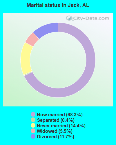
- Never married: 14.4%
- Now married: 68.3%
- Separated: 0.4%
- Widowed: 5.5%
- Divorced: 11.7%
For population 25 years and over in Jack:
- High school or higher: 65.4%
- Bachelor's degree or higher: 7.3%
- Graduate or professional degree: 1.8%
- Unemployed: 5.2%
- Mean travel time to work (commute): 27.7 minutes
| Here: | 15.2 |
| Alabama average: | 13.2 |
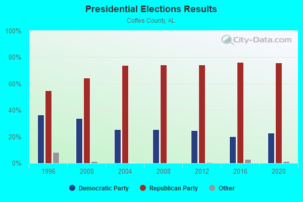
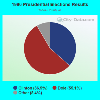
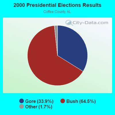


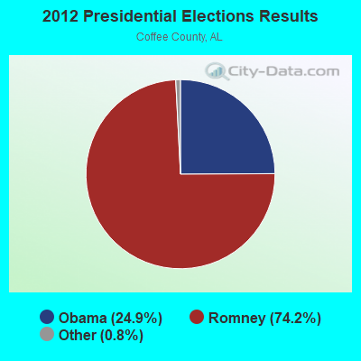
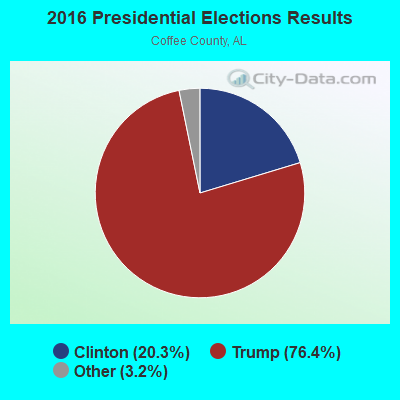
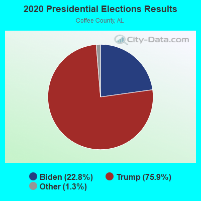
Graphs represent county-level data. Detailed 2008 Election Results
Religion statistics for Jack, AL (based on Coffee County data)
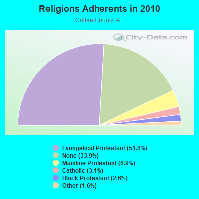
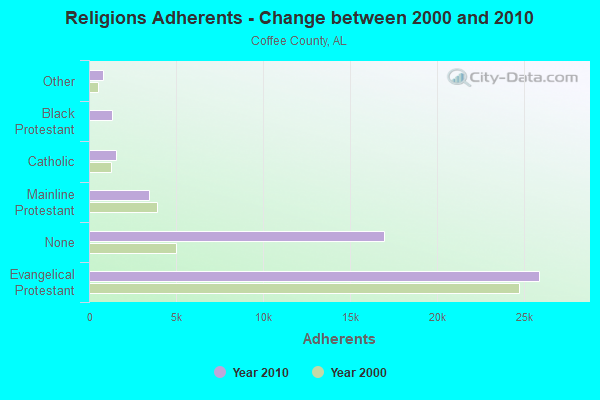
| Religion | Adherents | Congregations |
|---|---|---|
| Evangelical Protestant | 25,889 | 91 |
| Mainline Protestant | 3,457 | 13 |
| Catholic | 1,550 | 1 |
| Black Protestant | 1,320 | 11 |
| Other | 805 | 4 |
| None | 16,927 | - |
Food Environment Statistics:
| Coffee County: | 1.28 / 10,000 pop. |
| Alabama: | 1.89 / 10,000 pop. |
| Coffee County: | 0.21 / 10,000 pop. |
| Alabama: | 0.20 / 10,000 pop. |
| Coffee County: | 0.86 / 10,000 pop. |
| State: | 0.65 / 10,000 pop. |
| Coffee County: | 7.06 / 10,000 pop. |
| Alabama: | 6.32 / 10,000 pop. |
| Coffee County: | 7.91 / 10,000 pop. |
| State: | 5.75 / 10,000 pop. |
| Coffee County: | 10.8% |
| Alabama: | 11.8% |
| This county: | 32.5% |
| State: | 31.7% |
| Coffee County: | 16.6% |
| State: | 13.5% |
10.82% of this county's 2021 resident taxpayers lived in other counties in 2020 ($53,280 average adjusted gross income)
| Here: | 10.82% |
| Alabama average: | 6.87% |
0.18% of residents moved from foreign countries ($1,154 average AGI)
Coffee County: 0.18% Alabama average: 0.02%
Top counties from which taxpayers relocated into this county between 2020 and 2021:
| from Dale County, AL | |
| from Houston County, AL | |
| from Geneva County, AL |
10.45% of this county's 2020 resident taxpayers moved to other counties in 2021 ($53,500 average adjusted gross income)
| Here: | 10.45% |
| Alabama average: | 6.41% |
0.21% of residents moved to foreign countries ($1,557 average AGI)
Coffee County: 0.21% Alabama average: 0.02%
Top counties to which taxpayers relocated from this county between 2020 and 2021:
| to Dale County, AL | |
| to Houston County, AL | |
| to Geneva County, AL |
Strongest AM radio stations in Jack:
- WQLS (1200 AM; 10 kW; OZARK, AL; Owner: STYLES BROADCASTING OF DOTHAN, INC.)
- WELB (1350 AM; 1 kW; ELBA, AL; Owner: ELBA RADIO COMPANY)
- WTBF (970 AM; 5 kW; TROY, AL; Owner: TROY BROADCASTING CORP.)
- WTKN (1560 AM; daytime; 5 kW; DALEVILLE, AL; Owner: JOSEPH A. ADAMS, SR.)
- WASG (550 AM; 25 kW; ATMORE, AL; Owner: 550 AM, INC)
- WOPP (1290 AM; 2 kW; OPP, AL; Owner: E. & R BROADCASTING, INC.)
- WOOF (560 AM; 5 kW; DOTHAN, AL; Owner: WOOF, INC.)
- WMSP (740 AM; 10 kW; MONTGOMERY, AL; Owner: CUMULUS LICENSING CORP.)
- WJOX (690 AM; 50 kW; BIRMINGHAM, AL; Owner: CITADEL BROADCASTING COMPANY)
- WAMI (860 AM; 1 kW; OPP, AL; Owner: THE OPP BROADCASTING CO., INC.)
- WDJC (850 AM; 50 kW; BIRMINGHAM, AL; Owner: KIMTRON, INC.)
- WNSI (810 AM; 50 kW; JACKSONVILLE, AL; Owner: UNITED BROADCASTING NETWORK, INC.)
- WGST (640 AM; 50 kW; ATLANTA, GA; Owner: CITICASTERS LICENSES, L.P.)
Strongest FM radio stations in Jack:
- WKMX (106.7 FM; ENTERPRISE, AL; Owner: WKMX, INC.)
- WZTZ (101.1 FM; ELBA, AL; Owner: ELBA RADIO COMPANY)
- WQLD (104.3 FM; LUVERNE, AL; Owner: CAPSTAR TX LIMITED PARTNERSHIP)
- WZHT (105.7 FM; TROY, AL; Owner: CAPSTAR TX LIMITED PARTNERSHIP)
- WAXU (91.1 FM; TROY, AL; Owner: AMERICAN FAMILY ASSOCIATION)
- WTBF-FM (94.7 FM; BRUNDIDGE, AL; Owner: TROY BROADCASTING CORPORATION)
- WAOQ (100.3 FM; BRANTLEY, AL; Owner: ALATRON CORPORATION, INC.)
- WDJR (96.9 FM; ENTERPRISE, AL; Owner: GULF SOUTH COMMUNICATIONS, INC.)
- WLWI-FM (92.3 FM; MONTGOMERY, AL; Owner: CUMULUS LICENSING CORP.)
- WRJM-FM (93.7 FM; GENEVA, AL; Owner: STAGE DOOR DEVELOPMENT, INC.)
- WTSU (89.9 FM; MONTGOMERY-TROY, AL; Owner: TROY STATE UNIVERSITY)
- WDYF (90.3 FM; DOTHAN, AL; Owner: FAITH BROADCASTING, INC.)
- WXUS (100.5 FM; FORT RUCKER, AL; Owner: SKYWAY BROADCASTING, LTD.)
- WAMI-FM (102.3 FM; OPP, AL; Owner: THE OPP BROADCASTING CO., INC.)
- WOAB (104.9 FM; OZARK, AL; Owner: OZARK BROADCASTING CORPORATION)
TV broadcast stations around Jack:
- WDIQ (Channel 2; DOZIER, AL; Owner: ALABAMA EDUCATIONAL TELEVISION COMMISSION)
- WRJM-TV (Channel 67; TROY, AL; Owner: JOSIE PARK BROADCASTING, INC.)
- WSFA (Channel 12; MONTGOMERY, AL; Owner: LIBCO, INC.)
- WCOV-TV (Channel 20; MONTGOMERY, AL; Owner: WOODS COMMUNICATIONS CORPORATION)
- WTVY (Channel 4; DOTHAN, AL; Owner: GRAY MIDAMERICA TV LICENSEE CORP.)
- WNCF (Channel 32; MONTGOMERY, AL; Owner: CHANNEL 32 MONTGOMERY LLC)
- WDFX-TV (Channel 34; OZARK, AL; Owner: WAITT LICENSE CO. OF ALABAMA, L.L.C.)
- WGIQ (Channel 43; LOUISVILLE, AL; Owner: ALABAMA EDUCATIONAL TELEVISION COMMISSION)
FCC Registered Antenna Towers:
14 (See the full list of FCC Registered Antenna Towers in Jack)FCC Registered Microwave Towers:
1- JACK, 288 County Road 200 (15230807) (Lat: 31.590944 Lon: -85.943417), Type: Ltower, Structure height: 76.2 m, Overall height: 79.2 m, Call Sign: WRFP219,
Assigned Frequencies: 11385.0 MHz, 11425.0 MHz, 11385.0 MHz, 11425.0 MHz, 11385.0 MHz, 11425.0 MHz, 11385.0 MHz, 11425.0 MHz, 11385.0 MHz, 11425.0 MHz, Grant Date: 04/06/2020, Expiration Date: 04/06/2030, Certifier: Christophe Le Scanve, Registrant: Cellco Partnership, 5055 North Point Pkwy, Np2ne Network Engineering, Alpharetta, GA 30022, Phone: (770) 797-1070, Email:
FCC Registered Amateur Radio Licenses:
27 (See the full list of FCC Registered Amateur Radio Licenses in Jack)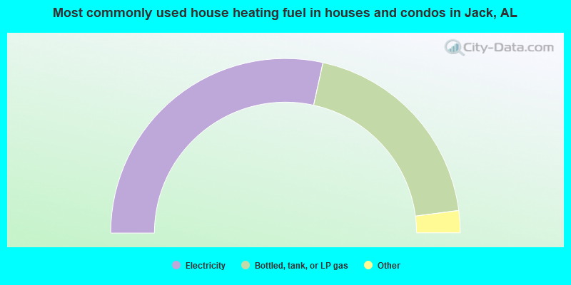
- 56.9%Electricity
- 39.0%Bottled, tank, or LP gas
- 2.1%Utility gas
- 1.1%Wood
- 0.9%Fuel oil, kerosene, etc.
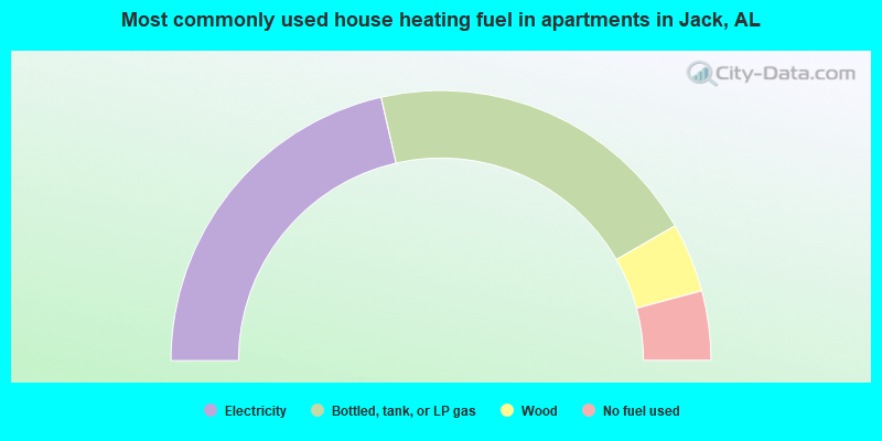
- 42.9%Electricity
- 40.5%Bottled, tank, or LP gas
- 8.3%Wood
- 8.3%No fuel used
Jack compared to Alabama state average:
- Median house value below state average.
- Unemployed percentage below state average.
- Black race population percentage significantly below state average.
- Hispanic race population percentage significantly below state average.
- Median age below state average.
- Foreign-born population percentage significantly below state average.
- Length of stay since moving in significantly above state average.
- Number of rooms per house significantly below state average.
- House age significantly below state average.
- Number of college students below state average.
- Percentage of population with a bachelor's degree or higher significantly below state average.