Leland, Michigan
Submit your own pictures of this place and show them to the world
- OSM Map
- Google Map
- MSN Map
| Males: 185 | |
| Females: 192 |
| Median resident age: | 50.0 years |
| Michigan median age: | 40.3 years |
Zip codes: 49654.
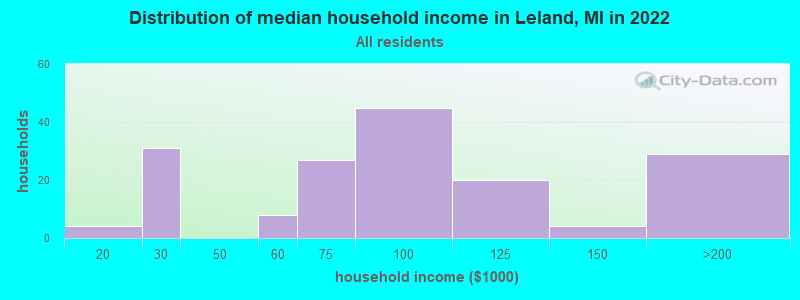
| Leland: | $80,519 |
| MI: | $66,986 |
Estimated per capita income in 2022: $48,775
Leland CDP income, earnings, and wages data
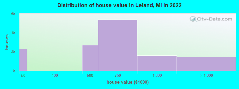
Estimated median house or condo value in 2022: $414,208
| Leland: | $414,208 |
| MI: | $224,400 |
Mean prices in 2022: all housing units: $752,988; detached houses: $752,025
(1.6% for White Non-Hispanic residents, 100.0% for Black residents, 11.6% for Hispanic or Latino residents)
Detailed information about poverty and poor residents in Leland, MI
Compare current foreclosures near your location:
| Photo | Address | Area | Beds / Baths | Price | Details |
|---|---|---|---|---|---|

|
#1
E 21st Ave
Columbus, OH 43211
|
1,061 sq. feet
|
1 baths 3 beds |
$187,900
|
show details |

|
#2
S High St
Columbus, OH 43207
|
1,678 sq. feet
|
2 baths 4 beds |
$31,900
|
show details |

|
#3
Bayberry Cir
Columbus, OH 43207
|
1,564 sq. feet
|
1 baths 3 beds |
$127,500
|
show details |

|
#4
Kingsglen Dr
Grove City, OH 43123
|
1,635 sq. feet
|
2 baths 4 beds |
show details | |

|
#5
Brookstone Dr
Westerville, OH 43082
|
1,783 sq. feet
|
3 baths 3 beds |
show details | |

|
#6
Falls Peak Ln
Delaware, OH 43015
|
1,352 sq. feet
|
2 baths 2 beds |
show details | |

|
#7
Meadowbrook Dr
Columbus, OH 43207
|
1,752 sq. feet
|
2 baths 4 beds |
show details | |

|
#8
Bunch Flower Ct
Westerville, OH 43082
|
3,173 sq. feet
|
2 baths 4 beds |
show details | |

|
#9
Sleeping Meadow Dr
New Albany, OH 43054
|
3,211 sq. feet
|
2 baths 4 beds |
show details | |

|
#10
Derrer Rd -872
Columbus, OH 43204
|
1,667 sq. feet
|
2 baths 5 beds |
show details |
| Photo | Address | Area | Beds / Baths | Price | Details |
|---|---|---|---|---|---|

|
#11
Elaine Rd
Columbus, OH 43213
|
764 sq. feet
|
1 baths 2 beds |
show details | |

|
#12
Mink St SW
Pataskala, OH 43062
|
1,442 sq. feet
|
1 baths 3 beds |
show details | |

|
#13
Bretton Pl
Columbus, OH 43211
|
1,056 sq. feet
|
1 baths 3 beds |
show details | |

|
#14
Wrexham Ave
Columbus, OH 43223
|
1,235 sq. feet
|
1 baths 3 beds |
show details | |

|
#15
Fergus Rd
Grove City, OH 43123
|
3,312 sq. feet
|
2 baths 4 beds |
show details | |

|
#16
Ferris Rd
Columbus, OH 43224
|
2,218 sq. feet
|
3 baths 3 beds |
show details | |

|
#17
S Hague Ave
Columbus, OH 43204
|
979 sq. feet
|
1 baths 2 beds |
show details | |

|
#18
Fahlander Dr N
Columbus, OH 43229
|
1,338 sq. feet
|
2 baths 3 beds |
show details | |

|
#19
Bernadette Rd
Columbus, OH 43204
|
1,168 sq. feet
|
1 baths 3 beds |
show details | |

|
#20
Midland Ave
Columbus, OH 43223
|
1,518 sq. feet
|
1 baths 2 beds |
show details |
| Photo | Address | Area | Beds / Baths | Price | Details |
|---|---|---|---|---|---|

|
#21
N Roys Ave
Columbus, OH 43204
|
1,248 sq. feet
|
2 baths 3 beds |
show details | |

|
#22
Marshrun Dr
Grove City, OH 43123
|
2,036 sq. feet
|
2 baths 4 beds |
show details | |

|
#23
N Grener Ave
Columbus, OH 43228
|
1,120 sq. feet
|
1 baths 3 beds |
show details | |

|
#24
Belle Oak Dr
Galloway, OH 43119
|
1,296 sq. feet
|
2 baths 3 beds |
show details | |

|
#25
Mayflower Blvd
Columbus, OH 43213
|
1,591 sq. feet
|
2 baths 4 beds |
show details | |

|
#26
Rosewood Ct
Powell, OH 43065
|
2,801 sq. feet
|
3 baths 4 beds |
show details | |

|
#27
High Free Pike
West Jefferson, OH 43162
|
1,216 sq. feet
|
2 baths 4 beds |
show details | |

|
#28
Stoneybrook Blvd # 21a
Hilliard, OH 43026
|
1,231 sq. feet
|
2 baths 3 beds |
show details | |

|
#29
S Richardson Ave
Columbus, OH 43204
|
1,520 sq. feet
|
2 baths 3 beds |
show details | |

|
#30
Edgeview Rd
Columbus, OH 43207
|
1,700 sq. feet
|
1 baths 4 beds |
show details |
| Photo | Address | Area | Beds / Baths | Price | Details |
|---|---|---|---|---|---|

|
#31
Striebel Ct
Columbus, OH 43227
|
925 sq. feet
|
1 baths 3 beds |
show details | |

|
#32
Scottwood Rd
Columbus, OH 43227
|
1,008 sq. feet
|
1 baths 3 beds |
show details | |

|
#33
Vineyard Haven Loop
Dublin, OH 43016
|
4,625 sq. feet
|
4 baths 4 beds |
show details | |

|
#34
S Chillicothe St
Plain City, OH 43064
|
1,736 sq. feet
|
2 baths 4 beds |
show details | |

|
#35
Trotter Dr
Columbus, OH 43207
|
1,478 sq. feet
|
1 baths 3 beds |
show details | |

|
#36
Doral Ave
Columbus, OH 43213
|
2,008 sq. feet
|
2 baths 4 beds |
show details | |

|
#37
Cole Rd
Columbus, OH 43228
|
1,833 sq. feet
|
2 baths 3 beds |
show details | |

|
#38
Bucknell Rd
Columbus, OH 43213
|
1,054 sq. feet
|
1 baths 3 beds |
show details | |

|
#39
Simpson Dr
Columbus, OH 43227
|
1,104 sq. feet
|
1 baths 3 beds |
show details | |

|
#40
Belfast Dr
Columbus, OH 43227
|
1,142 sq. feet
|
2 baths 3 beds |
show details |
| Photo | Address | Area | Beds / Baths | Price | Details |
|---|---|---|---|---|---|

|
#41
Morality Dr
Columbus, OH 43231
|
1,903 sq. feet
|
2 baths 4 beds |
show details | |

|
#42
Torchwood Loop E
Columbus, OH 43229
|
2,421 sq. feet
|
2 baths 5 beds |
show details | |

|
#43
Jason Dr
Columbus, OH 43227
|
1,602 sq. feet
|
2 baths 3 beds |
show details | |

|
#44
Omega Dr
Columbus, OH 43231
|
1,292 sq. feet
|
2 baths 3 beds |
show details | |

|
#45
Oklahoma Ave
Columbus, OH 43230
|
1,824 sq. feet
|
1 baths 4 beds |
show details | |

|
#46
Sapphire Dr
Grove City, OH 43123
|
3,241 sq. feet
|
3 baths 4 beds |
show details | |

|
#47
Colorado Ave
Groveport, OH 43125
|
1,502 sq. feet
|
1 baths 3 beds |
show details | |

|
#48
Allwood Ct
Columbus, OH 43231
|
1,683 sq. feet
|
2 baths 3 beds |
show details | |

|
#49
Jed Ct
Columbus, OH 43227
|
1,086 sq. feet
|
1 baths 3 beds |
show details | |

|
Check over 1 million property listings on Foreclosure.com!
|
browse all offers | |||


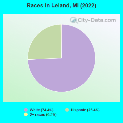
- 26174.4%White alone
- 8925.4%Hispanic
- 10.3%Two or more races
Races in Leland detailed stats: ancestries, foreign born residents, place of birth
According to our research of Michigan and other state lists, there was 1 registered sex offender living in Leland, Michigan as of April 25, 2024.
The ratio of all residents to sex offenders in Leland is 353 to 1.
The ratio of registered sex offenders to all residents in this city is near the state average.
 Recent articles from our blog. Our writers, many of them Ph.D. graduates or candidates, create easy-to-read articles on a wide variety of topics.
Ancestries: German (26.3%), Scottish (15.8%), English (13.8%), Belgian (11.2%), Norwegian (9.9%), Italian (3.3%).
Current Local Time: EST time zone
Elevation: 602 feet
5 residents are foreign born
| This place: | 1.4% |
| Michigan: | 6.9% |
Nearest city with pop. 50,000+: Green Bay, WI  (116.3 miles , pop. 102,313).
Nearest city with pop. 200,000+: Milwaukee, WI (174.7 miles , pop. 596,974).
Nearest city with pop. 1,000,000+: Chicago, IL (240.3 miles , pop. 2,896,016).
Nearest cities:
), ), ), ), )Latitude: 45.02 N, Longitude: 85.76 W
Area code commonly used in this area: 231
| Here: | 3.6% |
| Michigan: | 3.5% |
Tornado activity:
Leland-area historical tornado activity is significantly below Michigan state average. It is 75% smaller than the overall U.S. average.
On 4/3/1956, a category F4 (max. wind speeds 207-260 mph) tornado 13.2 miles away from the Leland place center killed 2 people and injured 24 people and caused between $50,000 and $500,000 in damages.
On 6/26/1969, a category F3 (max. wind speeds 158-206 mph) tornado 16.8 miles away from the place center caused between $50,000 and $500,000 in damages.
Earthquake activity:
Leland-area historical earthquake activity is near Michigan state average. It is 89% smaller than the overall U.S. average.On 9/25/1998 at 19:52:52, a magnitude 5.2 (4.8 MB, 4.3 MS, 5.2 LG, 4.5 MW, Depth: 3.1 mi, Class: Moderate, Intensity: VI - VII) earthquake occurred 364.1 miles away from the city center
On 1/31/1986 at 16:46:43, a magnitude 5.0 (5.0 MB) earthquake occurred 330.9 miles away from the city center
On 5/2/2015 at 16:23:07, a magnitude 4.2 (4.2 MW, Depth: 2.8 mi, Class: Light, Intensity: IV - V) earthquake occurred 193.5 miles away from the city center
On 7/12/1986 at 08:19:37, a magnitude 4.5 (4.5 MB) earthquake occurred 318.2 miles away from Leland center
On 9/2/1994 at 21:23:06, a magnitude 3.5 (3.4 LG, 3.5 LG, Depth: 3.1 mi, Class: Light, Intensity: II - III) earthquake occurred 164.3 miles away from the city center
On 6/28/2004 at 06:10:52, a magnitude 4.2 (4.2 MW, Depth: 6.2 mi) earthquake occurred 292.8 miles away from Leland center
Magnitude types: regional Lg-wave magnitude (LG), body-wave magnitude (MB), surface-wave magnitude (MS), moment magnitude (MW)
Natural disasters:
The number of natural disasters in Leelanau County (4) is a lot smaller than the US average (15).Emergencies Declared: 3
Causes of natural disasters: Blizzard: 1, Drought: 1, Hurricane: 1, Snowstorm: 1, Other: 1 (Note: some incidents may be assigned to more than one category).
Hospitals and medical centers near Leland:
- LEELANAU MEMORIAL HEALTH CENTER (Hospital, about 10 miles away; NORTHPORT, MI)
- TENDERCARE HEALTH CENTER OF LEELANAU (Nursing Home, about 11 miles away; SUTTONS BAY, MI)
- MAPLE VALLEY NURSING HOME (Nursing Home, about 14 miles away; MAPLE CITY, MI)
- ORCHARD CREEK SKILLED NURSING (Nursing Home, about 16 miles away; TRAVERSE CITY, MI)
Colleges/universities with over 2000 students nearest to Leland:
- Northwestern Michigan College (about 20 miles; Traverse City, MI; Full-time enrollment: 3,276)
- Mid Michigan Community College (about 88 miles; Harrison, MI; FT enrollment: 3,653)
- Ferris State University (about 94 miles; Big Rapids, MI; FT enrollment: 11,238)
- Central Michigan University (about 111 miles; Mount Pleasant, MI; FT enrollment: 22,758)
- University of Wisconsin-Green Bay (about 112 miles; Green Bay, WI; FT enrollment: 5,415)
- Northeast Wisconsin Technical College (about 121 miles; Green Bay, WI; FT enrollment: 6,069)
- Saint Norbert College (about 121 miles; De Pere, WI; FT enrollment: 2,324)
Public high school in Leland:
- KENSINGTON WOODS HIGH SCHOOL (Students: 266, Location: 9501 PETTYS ROAD, Grades: 6-12, Charter school)
Points of interest:
Notable locations in Leland: Leland Yacht Harbor (A), Manitou Mail Boat Deck (B), Manitou Island Ferry (C), Leland Country Club (D), Leland Township Library (E), Leelanau Historical Museum (F), Leland Township Fire and Rescue Department (G). Display/hide their locations on the map
Church in Leland: Immanuel Lutheran Church (A). Display/hide its location on the map
Cemetery: Leland Catholic Cemetery (1). Display/hide its location on the map
Parks in Leland include: Bartholomew Park (1), Hancock Recreation Area (2), Leland Historic District (Fishtown) Historical Marker (3). Display/hide their locations on the map
Hotel: Falling Waters Lodge (200 West Cedar).
Drinking water stations with addresses in Leland and their reported violations in the past:
LELAND BUILDING (Population served: 189, Groundwater):Past health violations:LELAND TOWNSHIP BALL DIAMOND (Population served: 150, Groundwater):
- MCL, Monthly (TCR) - In NOV-2010, Contaminant: Coliform. Follow-up actions: St Public Notif requested (NOV-05-2010), St Violation/Reminder Notice (NOV-05-2010), St Public Notif received (NOV-08-2010), St Compliance achieved (NOV-10-2010)
Past monitoring violations:HARBOR HOUSE TRADING COMPANY (Population served: 100, Groundwater):
- One routine major monitoring violation
Past monitoring violations:
- 5 routine major monitoring violations
- 2 regular monitoring violations
Drinking water stations with addresses in Leland that have no violations reported:
- THE COVE (Population served: 800, Primary Water Source Type: Groundwater)
- LELAND TOWNSHIP HARBOR (Population served: 500, Primary Water Source Type: Groundwater)
- LELAND COMMUNITY UNITED METHODIST CHURCH (Population served: 200, Primary Water Source Type: Groundwater)
- LELAND COUNTRY CLUB (Population served: 150, Primary Water Source Type: Groundwater)
- IMMANUEL LUTHERAN CHURCH (Population served: 150, Primary Water Source Type: Groundwater)
- LELAND TWP PUBLIC LIBRARY (Population served: 105, Primary Water Source Type: Groundwater)
- RIVERSIDE INN (Population served: 75, Primary Water Source Type: Groundwater)
- LELAND LODGE (Population served: 75, Primary Water Source Type: Groundwater)
- WHALEBACK INN (Population served: 45, Primary Water Source Type: Groundwater)
- LELAND TOWNSHIP FIRE DEPT. (Population served: 25, Primary Water Source Type: Groundwater)
| This place: | 1.9 people |
| Michigan: | 2.5 people |
| This place: | 58.5% |
| Whole state: | 66.0% |
| This place: | 1.0% |
| Whole state: | 6.4% |
Likely homosexual households (counted as self-reported same-sex unmarried-partner households)
- Lesbian couples: 0.5% of all households
- Gay men: 0.0% of all households
Banks with branches in Leland (2011 data):
- The Huntington National Bank: Leland Branch at 1111 North Main Street, branch established on 1970/05/20. Info updated 2012/04/02: Bank assets: $54,183.4 mil, Deposits: $44,300.3 mil, headquarters in Columbus, OH, positive income, Commercial Lending Specialization, 878 total offices, Holding Company: Huntington Bancshares Incorporated
- Northwestern Bank: Leland Branch at 115 North Main Street, branch established on 2007/06/20. Info updated 2006/11/03: Bank assets: $867.7 mil, Deposits: $784.0 mil, headquarters in Traverse City, MI, positive income, Commercial Lending Specialization, 27 total offices
For population 15 years and over in Leland:
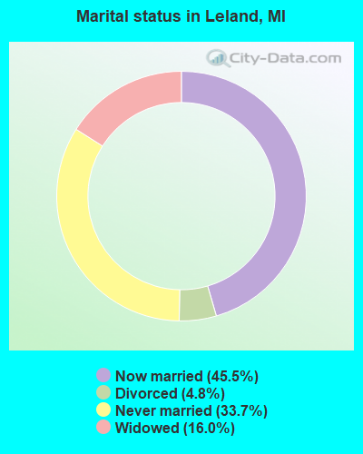
- Never married: 33.7%
- Now married: 45.5%
- Separated: 0.0%
- Widowed: 16.0%
- Divorced: 4.8%
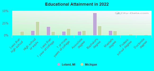
For population 25 years and over in Leland:
- High school or higher: 99.6%
- Bachelor's degree or higher: 53.6%
- Graduate or professional degree: 9.6%
| Here: | 6.3 |
| Michigan average: | 11.0 |
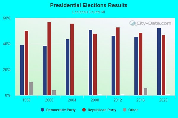
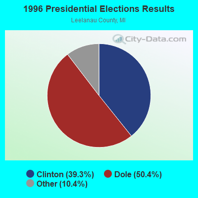
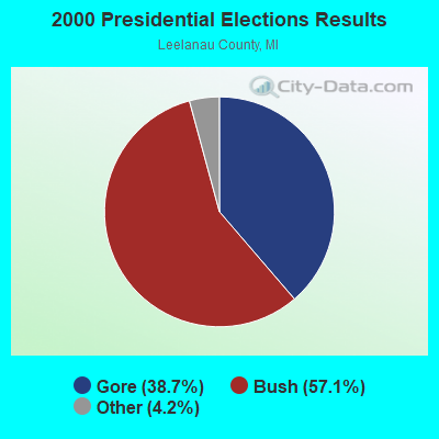
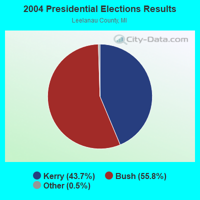
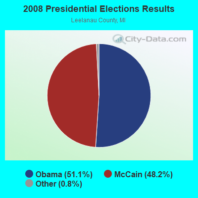
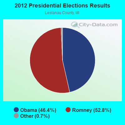
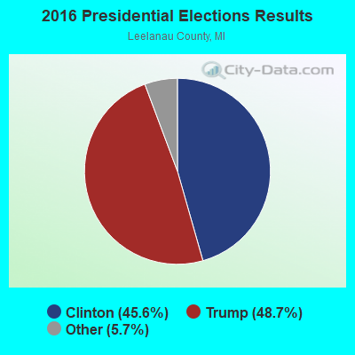
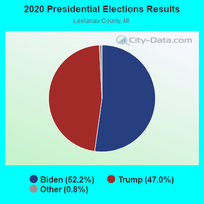
Graphs represent county-level data. Detailed 2008 Election Results
Religion statistics for Leland, MI (based on Leelanau County data)
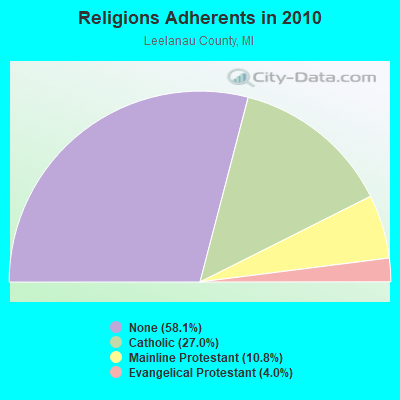
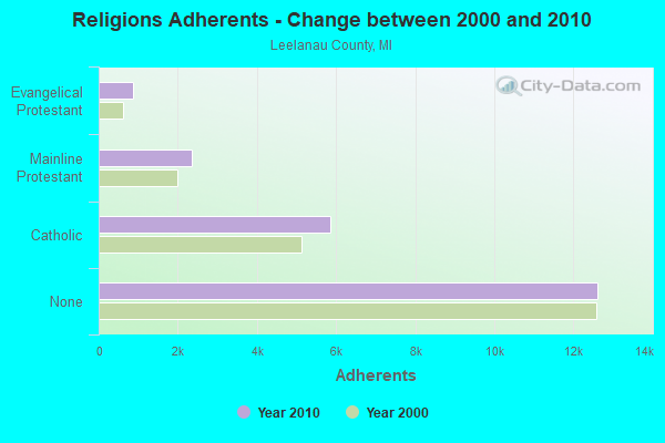
| Religion | Adherents | Congregations |
|---|---|---|
| Catholic | 5,861 | 8 |
| Mainline Protestant | 2,355 | 11 |
| Evangelical Protestant | 864 | 7 |
| Other | 7 | 2 |
| None | 12,621 | - |
Food Environment Statistics:
| Leelanau County: | 5.96 / 10,000 pop. |
| Michigan: | 2.34 / 10,000 pop. |
| This county: | 2.75 / 10,000 pop. |
| Michigan: | 1.52 / 10,000 pop. |
| This county: | 2.29 / 10,000 pop. |
| Michigan: | 2.99 / 10,000 pop. |
| Here: | 17.87 / 10,000 pop. |
| Michigan: | 6.80 / 10,000 pop. |
| Here: | 10.5% |
| State: | 9.7% |
| This county: | 29.5% |
| Michigan: | 29.7% |
| Leelanau County: | 21.2% |
| Michigan: | 13.4% |
Strongest AM radio stations in Leland:
- WTCM (580 AM; 35 kW; TRAVERSE CITY, MI; Owner: WTCM RADIO, INC.)
- WLDR (1210 AM; daytime; 50 kW; KINGSLEY, MI; Owner: FORT BEND BROADCASTING COMPANY)
- WCCW (1310 AM; 15 kW; TRAVERSE CITY, MI; Owner: WCCW RADIO, INC.)
- WMKT (1270 AM; 5 kW; CHARLEVOIX, MI; Owner: MACDONALD GARBER BROADCASTING, INC)
- WJML (1110 AM; 10 kW; PETOSKEY, MI)
- WDBC (680 AM; 10 kW; ESCANABA, MI; Owner: KMB BROADCASTING, INC.)
- WTMJ (620 AM; 50 kW; MILWAUKEE, WI; Owner: JOURNAL BROADCAST CORPORATION)
- WOAP (1080 AM; 50 kW; OWOSSO, MI)
- WNAM (1280 AM; 50 kW; NEENAH-MENASHA, WI; Owner: CUMULUS LICENSING CORP.)
- WLJN (1400 AM; 1 kW; ELMWOOD TOWNSHIP, MI; Owner: GOOD NEWS MEDIA, INC.)
- WSPT (1010 AM; 50 kW; STEVENS POINT, WI)
- WSCR (670 AM; 50 kW; CHICAGO, IL; Owner: INFINITY BROADCASTING OPERATIONS, INC.)
- WGN (720 AM; 50 kW; CHICAGO, IL; Owner: WGN CONTINENTAL BROADCASTING CO.)
Strongest FM radio stations in Leland:
- WFCX (94.3 FM; LELAND, MI; Owner: NORTHERN MICHIGAN RADIO, INC.)
- WJZJ (95.5 FM; GLEN ARBOR, MI; Owner: NORTHERN STAR BROADCASTING, L.L.C.)
- WGFN (98.1 FM; GLEN ARBOR, MI; Owner: NORTHERN STAR BROADCASTING, L.L.C.)
- WICA (91.5 FM; TRAVERSE CITY, MI; Owner: INTERLOCHEN CENTER FOR THE ARTS)
- WLDR-FM (101.9 FM; TRAVERSE CITY, MI; Owner: GREAT NORTHERN BROADCASTING SYSTEM, INC.)
- WLJN-FM (89.9 FM; TRAVERSE CITY, MI; Owner: GOOD NEWS MEDIA, INC.)
- WNMC-FM (90.7 FM; TRAVERSE CITY, MI; Owner: NORTHWESTERN MICHIGAN COLLEGE)
- W201CM (88.1 FM; TRAVERSE CITY, MI; Owner: PENSACOLA CHRISTIAN COLLEGE, INC.)
- WCCW-FM (107.5 FM; TRAVERSE CITY, MI; Owner: WCCW RADIO, INC.)
- WKHQ-FM (105.9 FM; CHARLEVOIX, MI; Owner: MACDONALD GARBER BROADCASTING, INC)
- WBCM (93.5 FM; BOYNE CITY, MI; Owner: WBCM RADIO, INC.)
- WTCM-FM (103.5 FM; TRAVERSE CITY, MI; Owner: WTCM RADIO, INC.)
- WKLT (97.5 FM; KALKASKA, MI; Owner: NORTHERN RADIO OF MICHIGAN, INC.)
- WJZQ (92.9 FM; CADILLAC, MI; Owner: WKJF RADIO, INC.)
- WKPK (106.7 FM; GAYLORD, MI; Owner: NORTHERN RADIO OF GAYLORD, INC.)
- WCZW (107.9 FM; CHARLEVOIX, MI; Owner: WCCW RADIO, INC.)
- WKVK (100.7 FM; HONOR, MI; Owner: NORTHERN RADIO OF MICHIGAN, INC.)
TV broadcast stations around Leland:
- W68DD (Channel 68; TRAVERSE CITY, MI; Owner: MS COMMUNICATIONS, LLC)
- W62CQ (Channel 62; TRAVERSE CITY, MI; Owner: MS COMMUNICATIONS, LLC)
- W36BZ (Channel 36; TRAVERSE CITY, MI; Owner: MS COMMUNICATIONS, LLC)
- WGTU (Channel 29; TRAVERSE CITY, MI; Owner: SCANLAN COMMUNICATIONS, INC.)
- WCMV (Channel 27; CADILLAC, MI; Owner: CENTRAL MICHIGAN UNIVERSITY)
- W25CU (Channel 25; TRAVERSE CITY, MI; Owner: EDWARD J. HESS AND/OR MADGE E. HESS)
- W56DF (Channel 56; TRAVERSE CITY, MI; Owner: MS COMMUNICATIONS, LLC)
- W15BM (Channel 15; TRAVERSE CITY, MI; Owner: MS COMMUNICATIONS, LLC)
- W34CE (Channel 34; TRAVERSE CITY, MI; Owner: MS COMMUNICATIONS, LLC)
- W48CC (Channel 48; TRAVERSE CITY, MI; Owner: MS COMMUNICATIONS, LLC)
- W52CP (Channel 52; TRAVERSE CITY, MI; Owner: MS COMMUNICATIONS, LLC)
- W58CN (Channel 58; TRAVERSE CITY, MI; Owner: MS COMMUNICATIONS, LLC)
- W66CX (Channel 66; TRAVERSE CITY, MI; Owner: MS COMMUNICATIONS, LLC)
- W54CR (Channel 54; TRAVERSE CITY, MI; Owner: ROCKFLEET BROADCASTING II, LLC)
- W69AV (Channel 69; LELAND, ETC., MI; Owner: CENTRAL MICHIGAN UNIVERSITY)
Leland fatal accident list:
Aug 20, 2016 07:56 AM, Sr-22 S Manitou Trl, Lat: 44.967028, Lon: -85.789844, Vehicles: 1, Persons: 5, Fatalities: 3
- National Bridge Inventory (NBI) Statistics
- 1Number of bridges
- 7ft / 1.8mTotal length
- 1,169Total average daily traffic
- 23Total average daily truck traffic
- 1,258Total future (year 2018) average daily traffic
FCC Registered Cell Phone Towers:
2- (Leland) 1.5 Km S Of M22 & Shomberg Rd. (Lat: 44.966417 Lon: -85.774500), Type: Gtower, Structure height: 140 m, Overall height: 146.3 m, Call Sign: KNKN910
Assigned Frequencies: 880.020 MHz, 835.020 MHz, 891.510 MHz, 846.510 MHz, 880.020 MHz, 880.020 MHz, 835.020 MHz, 835.020 MHz, 891.510 MHz, 891.510 MHz, 846.510 MHz, 846.510 MHzGrant Date: 01/28/2020, Expiration Date: 03/01/2030, Certifier: Gregory M RomanoRegistrant: Verizon Wireless, 5055 North Point Pkwy, Np2ne Network Engineering, Alpharetta, GA 30022, Phone: (770) 797-1070, Fax: (202) 783-5851, Email:
- 1117 South Pit Road (94608) (Lat: 44.966417 Lon: -85.774500), Type: Gtower, Structure height: 139.9 m, Overall height: 146.3 m, Call Sign: KNKN866, Licensee ID: L00128694
Assigned Frequencies: 869.040 MHz, 869.040 MHz, 869.040 MHz, 824.040 MHz, 824.040 MHz, 824.040 MHz, 890.010 MHz, 890.010 MHz, 890.010 MHz, 845.010 MHz, 845.010 MHz, 845.010 MHzGrant Date: 09/01/2020, Expiration Date: 10/01/2030, Certifier: Michael P GogginRegistrant: At&t Mobility Spectrum, LLC
FCC Registered Antenna Towers:
5- Tom Skowronski, 1.5 Km S Of M22 & Shomberg Rd. (Lat: 44.966389 Lon: -85.774167), Type: 146.3, Overall height: 140 m, Registrant: County Of Leelanau, 437 Lelan-d, Phone: (616) 256-2261
- Tom Skowronski, 1.5 Km S Of M22 & Shomberg Rd. (Lat: 44.966389 Lon: -85.774167), Type: 146.3, Overall height: 140 m, Registrant: County Of Leelanau, 437 Lelan-d, Phone: (616) 256-2261
- Tom Skowronski, 1.5 Km S Of M22 & Shomberg Rd. (Lat: 44.966417 Lon: -85.774500), Type: 146.3, Overall height: 140 m, Registrant: County Of Leelanau, Tskoronski@co.Leelanau.Mi, , Sutto-ns Bay, Phone: (616) 256-8775
- TOM SKOWRONSKI, 1.5 Km S Of M22 & Shomberg Rd. (Lat: 44.966417 Lon: -85.774500), Type: 146.3, Overall height: 140 m, Registrant: County Of Leelanau, Tskoronski@co.Leelanau.Mi, , Sutto-ns Bay, Phone: (616) 256-8775
- 1.5 Km S Of M22 & Shomberg Rd. (Lat: 44.966389 Lon: -85.774167), Type: 140.0, Overall height: 140 m, Registrant: County Of Leelanau, 437 Lelan-d, Phone: (616) 256-2261
FCC Registered Broadcast Land Mobile Towers:
7- 201 Chandler St County Sheriffs Dept (Lat: 45.019444 Lon: -85.756750), Call Sign: WNJV682,
Assigned Frequencies: 155.865 MHz, Grant Date: 06/26/2012, Expiration Date: 09/08/2022, Cancellation Date: 08/08/2012, Registrant: State Of Michigan, 4000 Collins Rd, Lansing, MI 48909-8131, Phone: (517) 336-2634, Fax: (517) 336-6222, Email:
- .27km S Of M22 Schomberg Rd (Lat: 44.966389 Lon: -85.774250), Type: Tower, Structure height: 140 m, Overall height: 146 m, Call Sign: WPDY700, Licensee ID: L00003832,
Assigned Frequencies: 154.250 MHz, 154.250 MHz, Grant Date: 02/28/2024, Expiration Date: 03/04/2034, Certifier: Richard Catton, Registrant: County Of Leelanau
- Leelanau County Tower (Lat: 44.966389 Lon: -85.774250), Type: Tower, Structure height: 140 m, Call Sign: WPQI448,
Assigned Frequencies: 851.012 MHz, 852.325 MHz, 851.937 MHz, 852.937 MHz, 853.437 MHz, 853.937 MHz, Grant Date: 05/13/2015, Expiration Date: 07/26/2025, Certifier: Harry Warner, Registrant: State Of Michigan, 7150 Harris Drive, Dimondale, MI 48821, Phone: (517) 333-5050, Email:
- 3 Mi S (Lat: 44.966389 Lon: -85.774250), Type: Tower, Structure height: 140 m, Overall height: 134 m, Call Sign: WPIY801,
Assigned Frequencies: 858.812 MHz, 859.812 MHz, 860.812 MHz, Grant Date: 03/26/2021, Expiration Date: 02/23/2031, Cancellation Date: 11/01/2023, Certifier: Donald R Stevenson, Registrant: Consumers Energy Company, 1945 West Parnall Road, Jackson, MI 49201, Phone: (517) 388-7380, Email:
- Lat: 45.025500 Lon: -85.751333, Call Sign: WQAC440,
Assigned Frequencies: 451.312 MHz, 451.412 MHz, 456.312 MHz, 456.412 MHz, Grant Date: 05/04/2004, Expiration Date: 05/04/2014, Cancellation Date: 07/05/2014, Certifier: Calvin Boone, Registrant: Cara Enterprises Inc, Salt Lake City, UT 84117-0503, Phone: (801) 278-9728, Fax: (801) 278-7239
- Lat: 44.938611 Lon: -85.738333, Call Sign: WQJJ873,
Assigned Frequencies: 154.717 MHz, 158.812 MHz, Grant Date: 09/08/2018, Expiration Date: 10/06/2028, Certifier: Tom Skowronski, Registrant: Radio North, 2682 Garfield Rd N Suite 22, Traverse City, MI 49686, Phone: (231) 929-2934, Fax: (231) 929-4580, Email:
- 7101, 1.5 Km S Of M22 & Shomberg Rd. (Lat: 44.966417 Lon: -85.774500), Type: Mast, Structure height: 140 m, Overall height: 146.3 m, Call Sign: WRQB952,
Assigned Frequencies: 860.812 MHz, Grant Date: 04/19/2022, Expiration Date: 04/19/2032, Certifier: Daniel J Robinson, Registrant: Consumers Energy Company, 1945 West Parnall Road, Jackson, MI 49201, Phone: (517) 388-7380, Email:
FCC Registered Microwave Towers:
4- LELAND, 1.5 Km S Of M22 & Shomberg Rd. (Lat: 44.966389 Lon: -85.774167), Type: Tower, Structure height: 140 m, Call Sign: WNTU338,
Assigned Frequencies: 6750.00 MHz, Grant Date: 10/31/2008, Expiration Date: 01/24/2019, Cancellation Date: 12/15/2011, Registrant: Radio North, 2682 Garfield Rd N Suite 22, Traverse City, MI 49686, Phone: (231) 929-2934, Fax: (231) 929-4580, Email:
- 7101 LELAND, 1.5 Km S Of M22 & Shomberg Rd. (Lat: 44.966389 Lon: -85.774528), Type: Gtower, Structure height: 140 m, Overall height: 146.3 m, Call Sign: WPQL958,
Assigned Frequencies: 6835.00 MHz, Grant Date: 03/24/2020, Expiration Date: 06/02/2030, Certifier: Harry Warner, Registrant: State Of Michigan, 7150 Harris Drive, Dimondale, MI 48821, Phone: (517) 333-5050, Email:
- LCCTWR, 1.5 Km S Of M22 & Shomberg Rd. (Lat: 44.966417 Lon: -85.774500), Type: Gtower, Structure height: 140 m, Overall height: 146.3 m, Call Sign: WQPY279,
Assigned Frequencies: 11305.0 MHz, 11265.0 MHz, 11305.0 MHz, 11265.0 MHz, 11305.0 MHz, 11265.0 MHz, 11305.0 MHz, 11265.0 MHz, Grant Date: 09/17/2012, Expiration Date: 09/17/2022, Cancellation Date: 11/19/2022, Certifier: Tom Skowronski, Registrant: Municipal Services Consulting, 2682 Garfield Rd N, Suite 22, Traverse City, MI 49686, Phone: (231) 929-2934, Email:
- 26089 PIT LLND, 1.5 Km S Of M22 & Shomberg Rd. (Lat: 44.966417 Lon: -85.774500), Type: Gtower, Structure height: 140 m, Overall height: 146.3 m, Call Sign: WRVY257,
Assigned Frequencies: 11485.0 MHz, 11645.0 MHz, 11485.0 MHz, 11645.0 MHz, 11485.0 MHz, 11645.0 MHz, 11485.0 MHz, 11645.0 MHz, 11485.0 MHz, 11645.0 MHz... (+10 more), Grant Date: 01/20/2023, Expiration Date: 01/20/2033, Certifier: Bob Sobieck, Registrant: Micronet Communications, Inc., 812 Lexington Dr, Plano, TX 75075, Phone: (972) 422-7200, Email:
FCC Registered Maritime Coast & Aviation Ground Towers:
2- Lake St (Lat: 45.023056 Lon: -85.757861), Overall height: 1 m, Call Sign: KLU820, Licensee ID: L00715640,
Assigned Frequencies: 156.450 MHz, 156.800 MHz, 156.325 MHz, Grant Date: 07/15/2003, Expiration Date: 09/30/2013, Cancellation Date: 11/30/2013, Registrant: Leland, Township Of, Lake St, Leland, MI 49654
- The Port Hole 207 River St (Lat: 45.016667 Lon: -85.766750), Overall height: 4 m, Call Sign: WQX713,
Assigned Frequencies: 156.425 MHz, 156.800 MHz, 156.450 MHz, Grant Date: 04/12/1999, Expiration Date: 06/09/2004, Cancellation Date: 08/15/2004, Registrant: G Michael Grosvenor, Leland, MI 49654
FCC Registered Amateur Radio Licenses:
5- Call Sign: K9TNT, Licensee ID: L00757853, Grant Date: 06/17/1999, Expiration Date: 01/14/2008, Cancellation Date: 11/27/2007, Registrant: James L Duff, 302 S. Main, Leland, MI 49654
- Call Sign: KA8FSP, Grant Date: 04/24/1998, Expiration Date: 04/24/2008, Cancellation Date: 04/27/2010, Registrant: Anton De Kok, Leland, MI 49654
- Call Sign: KA8UDX, Licensee ID: L00442635, Grant Date: 09/07/2006, Expiration Date: 11/05/2016, Cancellation Date: 11/06/2018, Certifier: Edward J Collins Jr, Registrant: Edward J Collins Jr, 512 Mill St, Leland, MI 49654-0593
- Call Sign: KC8BQN, Licensee ID: L01089830, Grant Date: 11/18/2015, Expiration Date: 11/28/2025, Certifier: Lowell V Jacobsen, Registrant: Lowell V Jacobsen, 521 Mill St, Leland, MI 49654-5048
- Call Sign: W9AL, Grant Date: 07/28/1994, Expiration Date: 07/28/2004, Cancellation Date: 10/12/1998, Registrant: Thurber G Bombaugh, 4157 Oxford Dr, Leland, MI 49654
FAA Registered Aircraft:
5- Aircraft: PIPER J-3 (Category: Land, Seats: 2, Weight: Up to 12,499 Pounds, Speed: 56 mph), Engine: FRANKLIN 4AC176B SER (65 HP) (Reciprocating)
N-Number: 2154M, N2154M, N-2154M, Serial Number: 20940, Certificate Issue Date: 06/22/2016
Registrant (Individual): Thomas A Trumbull, 1345 N Leland Estates Dr, Leland, MI 49654
Deregistered: Cancel Date: 07/13/2009 - Aircraft: PIPER PA-22-150 (Category: Land, Seats: 4, Weight: Up to 12,499 Pounds, Speed: 94 mph), Engine: LYCOMING 0-320 SERIES (180 HP) (Reciprocating)
N-Number: 3647P, N3647P, N-3647P, Serial Number: 22-3398, Year manufactured: 1955, Airworthiness Date: 11/15/1955, Certificate Issue Date: 07/02/2015
Registrant (LLC): Tripacer LLC, Po Box 1082 / Attn Robert Hubbard, Leland, MI 49654 - Aircraft: AEROFAB INC LAKE LA-250 (Category: Amphibian, Seats: 5, Weight: Up to 12,499 Pounds), Engine: LYCOMING IO-540 SER (300 HP) (Reciprocating)
N-Number: 8415P, N8415P, N-8415P, Serial Number: 71, Airworthiness Date: 04/15/1988, Certificate Issue Date: 08/16/2013
Registrant (LLC): Fathoms LLC, Po Box 426, Leland, MI 49654 - Aircraft: PIPER J-3 (Category: Land, Seats: 2, Weight: Up to 12,499 Pounds, Speed: 56 mph), Engine: CONT MOTOR A&C75 SERIES (75 HP) (Reciprocating)
N-Number: 88599, N88599, N-88599, Serial Number: 16225, Year manufactured: 1943, Airworthiness Date: 05/16/1977, Certificate Issue Date: 05/04/1999
Registrant (Individual): Thomas A Trumbull, 1345 N Leland Estates Dr, Leland, MI 49654 - Aircraft: PIPER J3C-65 (Category: Land, Seats: 2, Weight: Up to 12,499 Pounds, Speed: 67 mph), Engine: CONT MOTOR A&C65 SERIES (65 HP) (Reciprocating)
N-Number: 91923, N91923, N-91923, Serial Number: 16338, Year manufactured: 1946, Airworthiness Date: 04/05/1957, Certificate Issue Date: 06/24/2016
Registrant (Individual): Thomas A Trumbull, 1345 N Leland Estates Dr, Leland, MI 49654
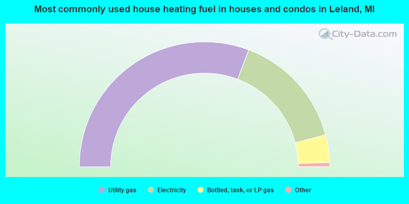
- 62.2%Utility gas
- 30.6%Electricity
- 7.2%Bottled, tank, or LP gas
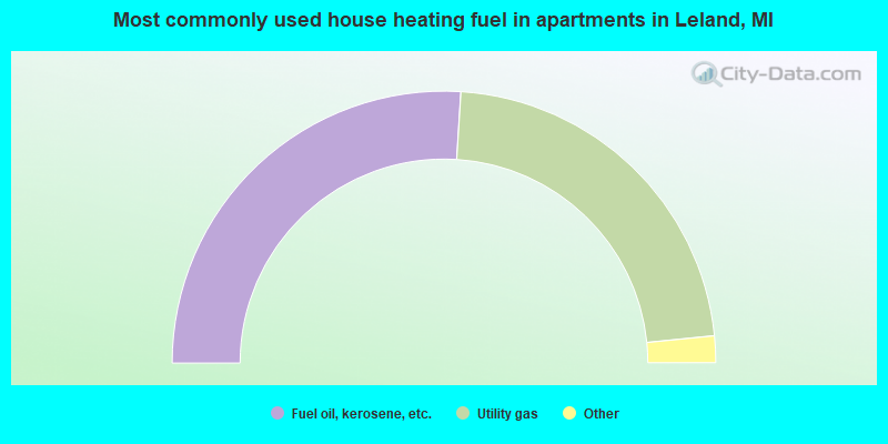
- 53.7%Fuel oil, kerosene, etc.
- 46.3%Utility gas
Leland compared to Michigan state average:
- Median house value significantly above state average.
- Unemployed percentage significantly below state average.
- Black race population percentage significantly below state average.
- Hispanic race population percentage significantly above state average.
- Median age significantly above state average.
- Foreign-born population percentage significantly below state average.
- Renting percentage below state average.
- Length of stay since moving in below state average.
- Percentage of population with a bachelor's degree or higher significantly above state average.

|
Total of 6 patent applications in 2008-2024.