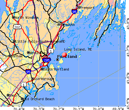
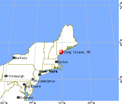
Long Island, Maine

Long Island: Tranquility
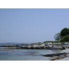
Long Island: Singing Sands Beach

Long Island: South Beach aka Sandy Beach
- add
your
Submit your own pictures of this town and show them to the world
- OSM Map
- General Map
- Google Map
- MSN Map
Population change since 2000: +13.9%
 |
| Males: 114 | |
| Females: 116 |
| Median resident age: | 52.0 years |
| Maine median age: | 43.0 years |
Zip codes: 04050.
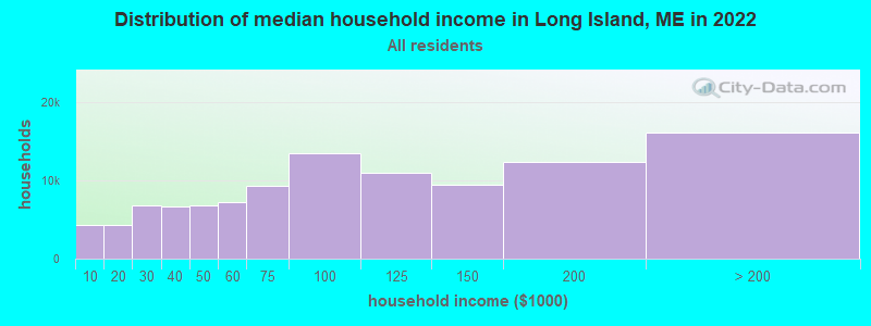
| Long Island: | $72,682 |
| ME: | $69,543 |
Estimated per capita income in 2022: $35,131 (it was $15,278 in 2000)
Long Island town income, earnings, and wages data
Estimated median house or condo value in 2022: $839,620 (it was $246,400 in 2000)
| Long Island: | $839,620 |
| ME: | $290,600 |
Mean prices in 2022: all housing units: $514,200; detached houses: $533,395; townhouses or other attached units: $572,947; in 2-unit structures: $538,406; in 3-to-4-unit structures: $462,507; in 5-or-more-unit structures: $450,834; mobile homes: $93,551
Detailed information about poverty and poor residents in Long Island, ME


- 21292.2%White alone
- 62.6%Asian alone
- 52.2%Black alone
- 52.2%Hispanic
- 10.4%American Indian alone
- 10.4%Two or more races
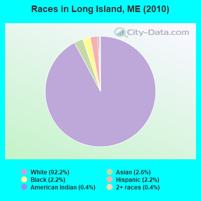
Races in Long Island detailed stats: ancestries, foreign born residents, place of birth
 Recent articles from our blog. Our writers, many of them Ph.D. graduates or candidates, create easy-to-read articles on a wide variety of topics.

 | Moving from Long Island, NY to Portland Area as a Nurse (2 replies) |
| People in Maine (21 replies) |
| Why is the coastal Maine housing market so hot right now? (6 replies) |
| Thinking of Moving to the GPA --> A Few Questions (11 replies) |
| High cancer rates in Maine??? (17 replies) |
| Is Southern Maine "Family Friendly"? (90 replies) |
Latest news from Long Island, ME collected exclusively by city-data.com from local newspapers, TV, and radio stations
Ancestries: English (34.2%), Scottish (29.7%), Irish (15.8%), German (13.9%), Norwegian (6.4%), Russian (5.4%).
Current Local Time: EST time zone
Incorporated on 04/03/1992
Elevation: 40 feet
Land area: 1.43 square miles.
Population density: 161 people per square mile (very low).
7 residents are foreign born (2.5% Europe, 1.0% Africa).
| This town: | 3.5% |
| Maine: | 2.9% |
| Long Island town: | 0.9% ($2,273) |
| Maine: | 1.5% ($1,417) |
Nearest city with pop. 50,000+: Portland, ME  (6.0 miles , pop. 64,249).
Nearest city with pop. 200,000+: Boston, MA (106.0 miles , pop. 589,141).
Nearest city with pop. 1,000,000+: Bronx, NY (273.7 miles , pop. 1,332,650).
Nearest cities:
), ), ), Latitude: 43.69 N, Longitude: 70.15 W
Area code commonly used in this area: 207

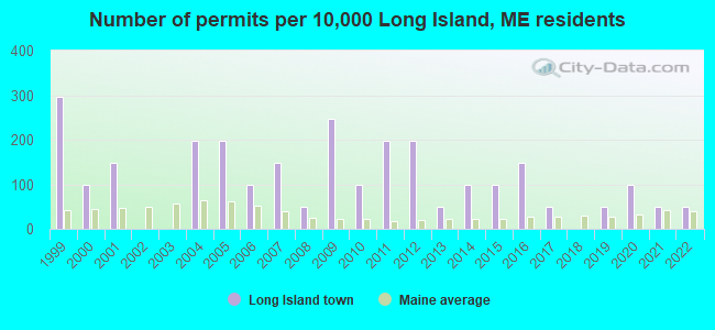
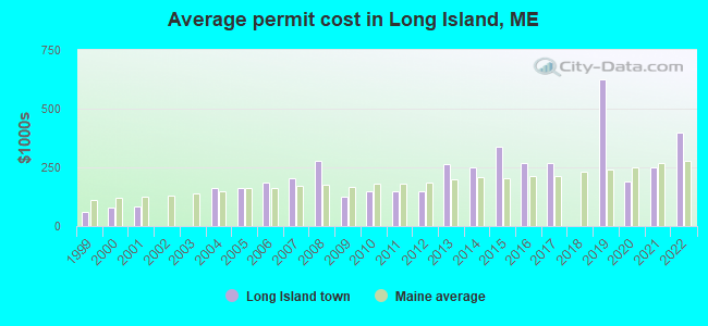
Single-family new house construction building permits:
- 2022: 1 building, cost: $400,000
- 2021: 1 building, cost: $250,000
- 2020: 2 buildings, average cost: $187,500
- 2019: 1 building, cost: $625,000
- 2017: 1 building, cost: $267,800
- 2016: 3 buildings, average cost: $266,700
- 2015: 2 buildings, average cost: $337,500
- 2014: 2 buildings, average cost: $250,000
- 2013: 1 building, cost: $262,500
- 2012: 4 buildings, average cost: $150,000
- 2011: 4 buildings, average cost: $150,000
- 2010: 2 buildings, average cost: $150,000
- 2009: 5 buildings, average cost: $125,000
- 2008: 1 building, cost: $278,100
- 2007: 3 buildings, average cost: $203,800
- 2006: 2 buildings, average cost: $186,000
- 2005: 4 buildings, average cost: $163,600
- 2004: 4 buildings, average cost: $163,600
- 2001: 3 buildings, average cost: $84,400
- 2000: 2 buildings, average cost: $77,200
- 1999: 6 buildings, average cost: $61,800
| Here: | 3.0% |
| Maine: | 3.4% |
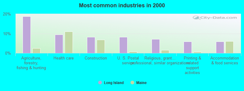
- Agriculture, forestry, fishing & hunting (18.8%)
- Health care (9.4%)
- Construction (8.2%)
- U. S. Postal service (8.2%)
- Religious, grantmaking, civic, professional, similar organizations (7.1%)
- Printing & related support activities (5.9%)
- Accommodation & food services (5.9%)
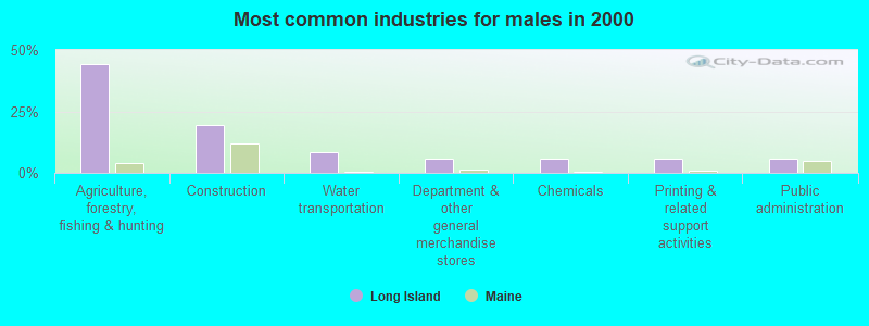
- Agriculture, forestry, fishing & hunting (44.4%)
- Construction (19.4%)
- Water transportation (8.3%)
- Department & other general merchandise stores (5.6%)
- Chemicals (5.6%)
- Printing & related support activities (5.6%)
- Public administration (5.6%)
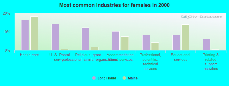
- Health care (16.3%)
- U. S. Postal service (14.3%)
- Religious, grantmaking, civic, professional, similar organizations (12.2%)
- Accommodation & food services (10.2%)
- Professional, scientific, technical services (8.2%)
- Educational services (8.2%)
- Printing & related support activities (6.1%)
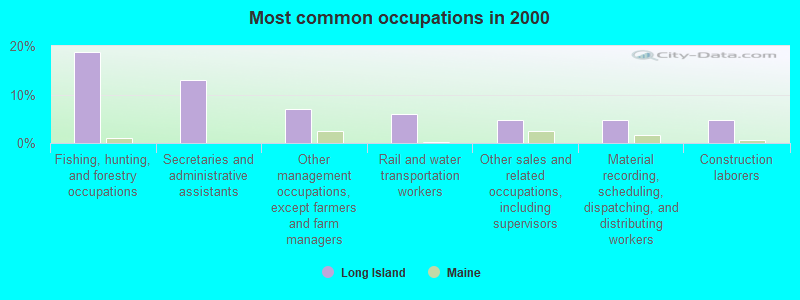
- Fishing, hunting, and forestry occupations (18.8%)
- Secretaries and administrative assistants (12.9%)
- Other management occupations, except farmers and farm managers (7.1%)
- Rail and water transportation workers (5.9%)
- Other sales and related occupations, including supervisors (4.7%)
- Material recording, scheduling, dispatching, and distributing workers (4.7%)
- Construction laborers (4.7%)
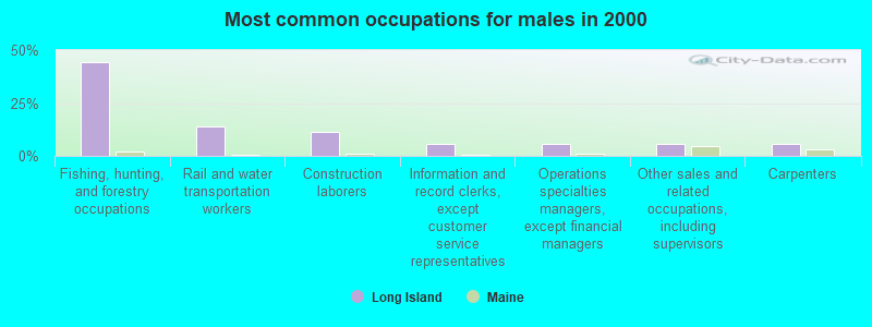
- Fishing, hunting, and forestry occupations (44.4%)
- Rail and water transportation workers (13.9%)
- Construction laborers (11.1%)
- Information and record clerks, except customer service representatives (5.6%)
- Operations specialties managers, except financial managers (5.6%)
- Other sales and related occupations, including supervisors (5.6%)
- Carpenters (5.6%)
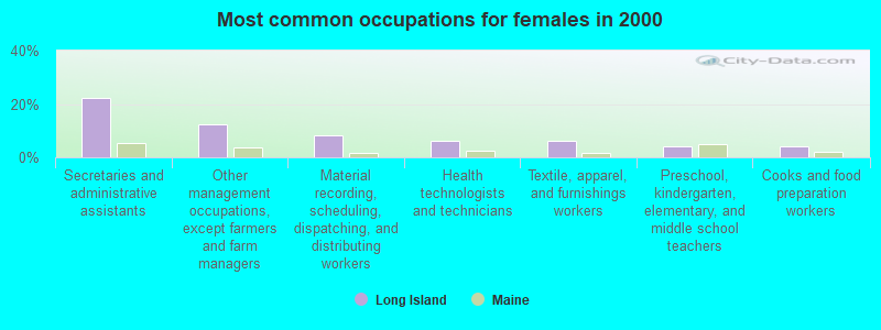
- Secretaries and administrative assistants (22.4%)
- Other management occupations, except farmers and farm managers (12.2%)
- Material recording, scheduling, dispatching, and distributing workers (8.2%)
- Health technologists and technicians (6.1%)
- Textile, apparel, and furnishings workers (6.1%)
- Preschool, kindergarten, elementary, and middle school teachers (4.1%)
- Cooks and food preparation workers (4.1%)
Average climate in Long Island, Maine
Based on data reported by over 4,000 weather stations


(lower is better)
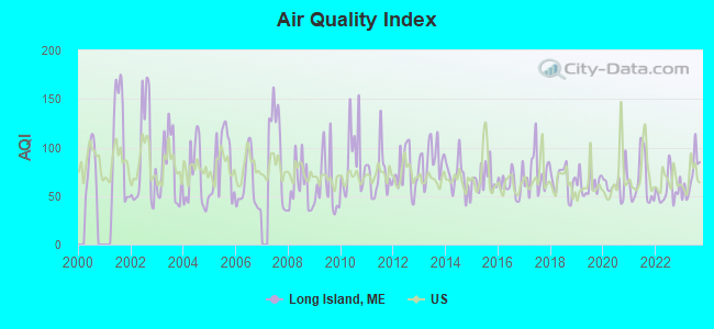
Air Quality Index (AQI) level in 2023 was 70.0. This is about average.
| City: | 70.0 |
| U.S.: | 72.6 |
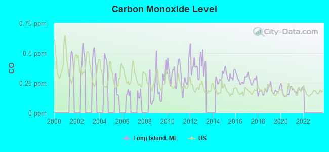
Carbon Monoxide (CO) [ppm] level in 2021 was 0.192. This is better than average. Closest monitor was 6.0 miles away from the city center.
| City: | 0.192 |
| U.S.: | 0.251 |
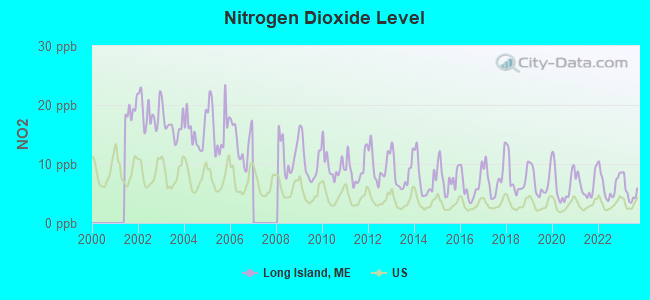
Nitrogen Dioxide (NO2) [ppb] level in 2023 was 5.47. This is about average. Closest monitor was 5.7 miles away from the city center.
| City: | 5.47 |
| U.S.: | 5.11 |
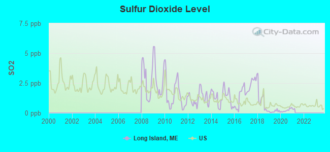
Sulfur Dioxide (SO2) [ppb] level in 2020 was 0.222. This is significantly better than average. Closest monitor was 2.2 miles away from the city center.
| City: | 0.222 |
| U.S.: | 1.515 |
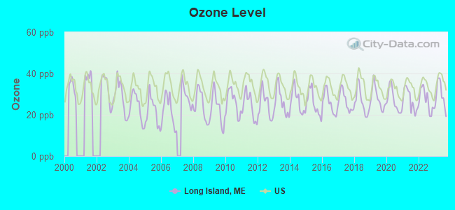
Ozone [ppb] level in 2023 was 29.6. This is about average. Closest monitor was 5.7 miles away from the city center.
| City: | 29.6 |
| U.S.: | 33.3 |
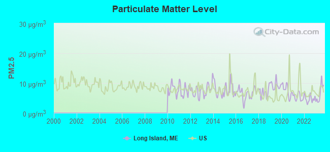
Particulate Matter (PM2.5) [µg/m3] level in 2023 was 6.57. This is better than average. Closest monitor was 5.2 miles away from the city center.
| City: | 6.57 |
| U.S.: | 8.11 |
Earthquake activity:
Long Island-area historical earthquake activity is significantly above Maine state average. It is 75% smaller than the overall U.S. average.On 10/16/2012 at 23:12:25, a magnitude 4.7 (4.7 ML, Depth: 10.0 mi, Class: Light, Intensity: IV - V) earthquake occurred 25.9 miles away from the city center
On 4/20/2002 at 10:50:47, a magnitude 5.3 (5.3 ML, Depth: 3.0 mi, Class: Moderate, Intensity: VI - VII) earthquake occurred 184.8 miles away from the city center
On 1/19/1982 at 00:14:42, a magnitude 4.7 (4.5 MB, 4.7 MD, 4.5 LG) earthquake occurred 73.6 miles away from the city center
On 4/20/2002 at 10:50:47, a magnitude 5.2 (5.2 MB, 4.2 MS, 5.2 MW, 5.0 MW) earthquake occurred 185.3 miles away from Long Island center
On 10/7/1983 at 10:18:46, a magnitude 5.3 (5.1 MB, 5.3 LG, 5.1 ML) earthquake occurred 209.7 miles away from Long Island center
On 2/26/1999 at 03:38:43, a magnitude 3.8 (3.8 LG, Depth: 2.0 mi, Class: Light, Intensity: II - III) earthquake occurred 62.9 miles away from the city center
Magnitude types: regional Lg-wave magnitude (LG), body-wave magnitude (MB), duration magnitude (MD), local magnitude (ML), surface-wave magnitude (MS), moment magnitude (MW)
Natural disasters:
The number of natural disasters in Cumberland County (33) is a lot greater than the US average (15).Major Disasters (Presidential) Declared: 22
Emergencies Declared: 10
Causes of natural disasters: Floods: 19, Storms: 13, Snows: 7, Winter Storms: 6, Heavy Rains: 3, Hurricanes: 3, Winds: 3, Blizzard: 1, Ice Storm: 1, Mudslide: 1, Snowfall: 1, Snowstorm: 1, Tornado: 1, Other: 2 (Note: some incidents may be assigned to more than one category).

Hospitals and medical centers near Long Island:
- FALMOUTH BY THE SEA (Nursing Home, about 4 miles away; FALMOUTH, ME)
- SEDGEWOOD COMMONS (Nursing Home, about 5 miles away; FALMOUTH, ME)
- HILLSIDE REST AND NURSING HOME (Nursing Home, about 6 miles away; PORTLAND, ME)
- BETTER HEALTH CARE INC (Home Health Center, about 6 miles away; PORTLAND, ME)
- SEASIDE REHAB AND HEALTH CARE (Nursing Home, about 6 miles away; PORTLAND, ME)
- CHS - HOSPICE (Hospital, about 6 miles away; PORTLAND, ME)
- MERCY HOSPITAL Acute Care Hospitals (about 7 miles away; PORTLAND, ME)
Amtrak stations near Long Island:
Colleges/universities with over 2000 students nearest to Long Island:
- Southern Maine Community College (about 5 miles; South Portland, ME; Full-time enrollment: 4,666)
- University of Southern Maine (about 7 miles; Portland, ME; FT enrollment: 6,647)
- Saint Joseph's College of Maine (about 19 miles; Standish, ME; FT enrollment: 2,010)
- University of New England (about 20 miles; Biddeford, ME; FT enrollment: 4,539)
- University of Maine at Augusta (about 49 miles; Augusta, ME; FT enrollment: 3,204)
- University of New Hampshire-Main Campus (about 56 miles; Durham, NH; FT enrollment: 15,243)
- University of Maine at Farmington (about 68 miles; Farmington, ME; FT enrollment: 2,036)
Public elementary/middle school in Long Island:
- LONG ISLAND ELEMENTARY SCHOOL (Location: FERN AVENUE, Grades: KG-4)
Points of interest:
Notable location: Long Island Fire and Rescue (A). Display/hide its location on the map
Beach: Andrews Beach (A). Display/hide its location on the map
| This town: | 2.3 people |
| Maine: | 2.3 people |
| This town: | 70.7% |
| Whole state: | 62.9% |
| This town: | 0.0% |
| Whole state: | 9.4% |
No gay or lesbian households reported
| This town: | 10.0% |
| Whole state: | 10.9% |
| This town: | 6.0% |
| Whole state: | 4.1% |
For population 15 years and over in Long Island:
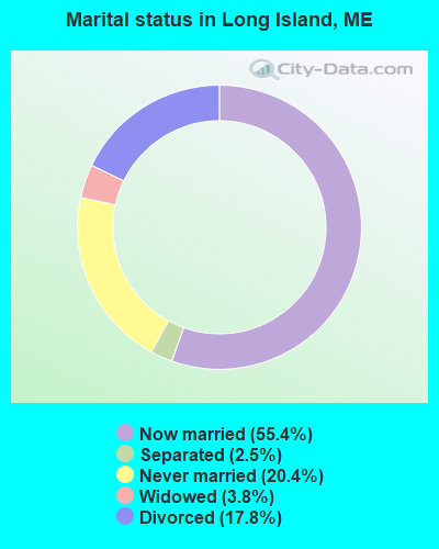
- Never married: 20.4%
- Now married: 55.4%
- Separated: 2.5%
- Widowed: 3.8%
- Divorced: 17.8%
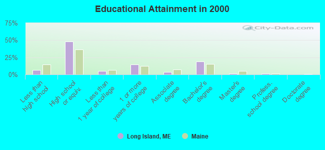
For population 25 years and over in Long Island:
- High school or higher: 93.4%
- Bachelor's degree or higher: 22.1%
- Graduate or professional degree: 2.9%
- Unemployed: 4.5%
- Mean travel time to work (commute): 34.6 minutes
| Here: | 8.3 |
| Maine average: | 11.2 |
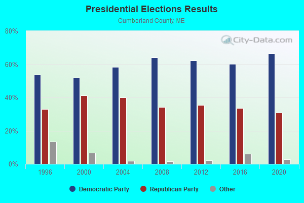
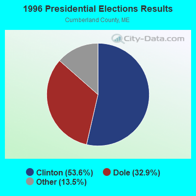
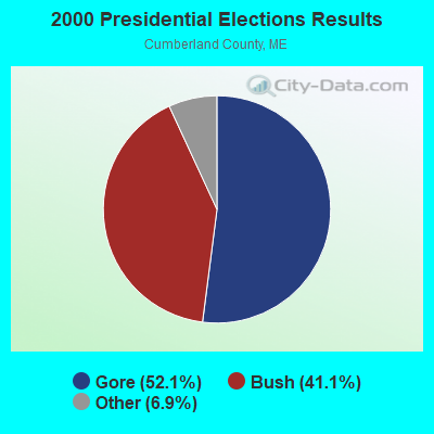


Graphs represent county-level data. Detailed 2008 Election Results
Religion statistics for Long Island, ME (based on Cumberland County data)
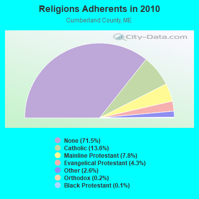
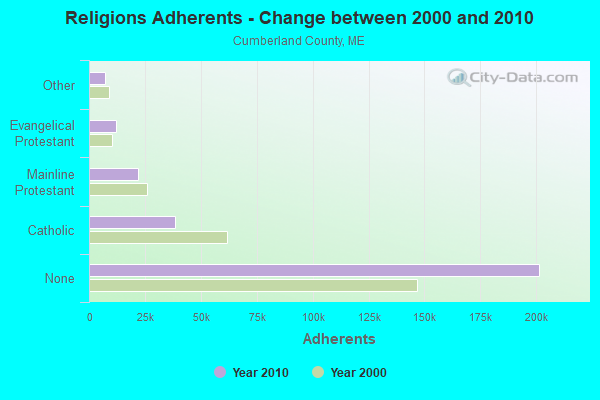
| Religion | Adherents | Congregations |
|---|---|---|
| Catholic | 38,243 | 19 |
| Mainline Protestant | 22,030 | 96 |
| Evangelical Protestant | 12,007 | 85 |
| Other | 7,187 | 44 |
| Orthodox | 500 | 1 |
| Black Protestant | 285 | 2 |
| None | 201,422 | - |
Food Environment Statistics:
| Cumberland County: | 2.62 / 10,000 pop. |
| Maine: | 2.80 / 10,000 pop. |
| Cumberland County: | 0.11 / 10,000 pop. |
| Maine: | 0.14 / 10,000 pop. |
| This county: | 2.44 / 10,000 pop. |
| State: | 2.20 / 10,000 pop. |
| Here: | 3.82 / 10,000 pop. |
| State: | 5.75 / 10,000 pop. |
| This county: | 12.01 / 10,000 pop. |
| State: | 11.02 / 10,000 pop. |
| Cumberland County: | 7.1% |
| State: | 8.2% |
| Here: | 19.5% |
| Maine: | 25.0% |
Strongest AM radio stations in Long Island:
- WGAN (560 AM; 5 kW; PORTLAND, ME; Owner: SAGA COMMUNICATIONS OF NEW ENGLAND, LLC)
- WZAN (970 AM; 5 kW; PORTLAND, ME; Owner: SAGA COMMUNICATIONS OF NEW ENGLAND, LLC)
- WLOB (1310 AM; 5 kW; PORTLAND, ME; Owner: ATLANTIC COAST RADIO, LLC)
- WMTW (870 AM; 10 kW; GORHAM, ME; Owner: RADIO PARTNERS OF MAINE, L.P.)
- WJAE (1440 AM; 5 kW; WESTBROOK, ME; Owner: ALTANTIC COAST RADIO, LLC)
- WBAE (1490 AM; 1 kW; PORTLAND, ME; Owner: SAGA COMMUNICATIONS OF NEW ENGLAND, LLC)
- WRKO (680 AM; 50 kW; BOSTON, MA; Owner: ENTERCOM BOSTON LICENSE, LLC)
- WLAM (1470 AM; 5 kW; LEWISTON, ME; Owner: RADIO PARTNERS OF MAINE, L.P.)
- WEEI (850 AM; 50 kW; BOSTON, MA; Owner: ENTERCOM BOSTON LICENSE, LLC)
- WGIN (930 AM; 10 kW; ROCHESTER, NH; Owner: CAPSTAR TX LIMITED PARTNERSHIP)
- WBZ (1030 AM; 50 kW; BOSTON, MA; Owner: INFINITY BROADCASTING OPERATIONS, INC.)
- WTME (780 AM; 10 kW; RUMFORD, ME; Owner: MOUNTAIN VALLEY BROADCASTING, INC.)
- WJJB (900 AM; 1 kW; BRUNSWICK, ME; Owner: ATLANTIC COAST RADIO, LLC)
Strongest FM radio stations in Long Island:
- WYNZ (100.9 FM; WESTBROOK, ME; Owner: SAGA COMMUNICATIONS OF NEW ENGLAND, LLC)
- WMGX (93.1 FM; PORTLAND, ME; Owner: SAGA COMMUNICATIONS OF NEW ENGLAND, LLC)
- WPOR (101.9 FM; PORTLAND, ME; Owner: SAGA COMMUNICATIONS OF NEW ENGLAND, LLC)
- WJBQ (97.9 FM; PORTLAND, ME; Owner: CITADEL BROADCASTING COMPANY)
- WMSJ (89.3 FM; FREEPORT, ME; Owner: DOWNEAST CHRISTIAN COMMUNICATIONS)
- WBLM (102.9 FM; PORTLAND, ME; Owner: CITADEL BROADCASTING COMPANY)
- WMEA (90.1 FM; PORTLAND, ME; Owner: MAINE PUBLIC BROADCASTING CORPORATION)
- WMTW-FM (106.7 FM; NORTH WINDHAM, ME; Owner: RADIO PARTNERS OF MAINE, L.P.)
- WYFP (91.9 FM; HARPSWELL, ME; Owner: BIBLE BROADCASTING NETWORK, INC.)
- W245AA (96.9 FM; PORTLAND, ME; Owner: RADIO PARTNERS OF MAINE, L.P.)
- WTHT (107.5 FM; LEWISTON, ME; Owner: RADIO PARTNERS OF MAINE, L.P.)
- WPKQ (103.7 FM; NORTH CONWAY, NH; Owner: CITADEL BROADCASTING COMPANY)
- WHOM (94.9 FM; MT. WASHINGTON, NH; Owner: CITADEL BROADCASTING COMPANY)
- WMEK-FM (99.9 FM; AUBURN, ME; Owner: RADIO PARTNERS OF MAINE, L.P.)
- WCYY (94.3 FM; BIDDEFORD, ME; Owner: CITADEL BROADCASTING COMPANY)
- WJJB-FM (95.5 FM; TOPSHAM, ME; Owner: ATLANTIC COAST RADIO, LLC)
- WRED (95.9 FM; SACO, ME; Owner: ATLANTIC COAST RADIO, LLC)
- WCLZ (98.9 FM; BRUNSWICK, ME; Owner: CITADEL BROADCASTING COMPANY)
- WBQW (106.3 FM; SCARBOROUGH, ME; Owner: MARINER BROADCASTING LIMITED PARTNER)
- WSCY (106.9 FM; MOULTONBOROUGH, NH; Owner: NORTHEAST COMMUNICATIONS CORPORATION)
TV broadcast stations around Long Island:
- WGME-TV (Channel 13; PORTLAND, ME; Owner: WGME LICENSEE, LLC)
- WPXT (Channel 51; PORTLAND, ME; Owner: HMW, INC.)
- WPME (Channel 35; LEWISTON, ME; Owner: KB PRIME MEDIA LLC)
- WMTW-TV (Channel 8; POLAND SPRING, ME; Owner: WMTW BROADCAST GROUP, LLC)
- W32CA (Channel 32; PORTLAND, ME; Owner: NATIONAL MINORITY T.V., INC.)
- WCSH (Channel 6; PORTLAND, ME; Owner: PACIFIC AND SOUTHERN COMPANY, INC.)
- WMEA-TV (Channel 26; BIDDEFORD, ME; Owner: MAINE PUBLIC BROADCASTING CORP.)
- W58CM (Channel 58; BANGOR, ME; Owner: MS COMMUNICATIONS, LLC)
- W57AP (Channel 57; FALMOUTH, ME; Owner: SHERWOOD H. CRAIG)
- WLLB-LP (Channel 15; PORTLAND, ME; Owner: CARTER BROADCASTING CORPORATION)
- WPFO (Channel 23; WATERVILLE, ME; Owner: CMCG PORTLAND LICENSE LLC)
- WCBB (Channel 10; AUGUSTA, ME; Owner: MAINE PUBLIC BROADCASTING CORP.)
FCC Registered Microwave Towers:
1- FRENCHBORO, Rural Area (Lat: 44.117722 Lon: -68.367806), Type: Ltower, Structure height: 24.4 m, Call Sign: WHQ845,
Assigned Frequencies: 11485.0 MHz, 11485.0 MHz, 11485.0 MHz, 11485.0 MHz, 11485.0 MHz, 11485.0 MHz, 11485.0 MHz, 11485.0 MHz, 11485.0 MHz, 11485.0 MHz... (+28 more), Grant Date: 02/02/2021, Expiration Date: 02/01/2031, Registrant: Intelpath, Hinsdale, IL 60522, Phone: (312) 841-9188, Email:
FCC Registered Maritime Coast & Aviation Ground Towers:
1- 6 Island Ave (Lat: 43.689528 Lon: -70.168944), Type: Building, Overall height: 14 m, Call Sign: KVR479,
Assigned Frequencies: 156.425 MHz, 156.450 MHz, 156.500 MHz, 156.800 MHz, Grant Date: 08/08/2000, Expiration Date: 07/26/2005, Cancellation Date: 01/07/2006, Registrant: Clarkes Store Inc, 6 Island Ave, Long Island, ME 04050
FCC Registered Amateur Radio Licenses:
1- Call Sign: N1LI, Previous Call Sign: KB1KGL, Licensee ID: L00727597, Grant Date: 07/27/2023, Expiration Date: 09/12/2033, Certifier: Norman D Grant, Registrant: Long Island Dx Society, Long Island, ME 04050
FAA Registered Aircraft:
2- Aircraft: TAYLORCRAFT BC12-D (Category: Land, Seats: 2, Weight: Up to 12,499 Pounds, Speed: 78 mph), Engine: CONT MOTOR A&C65 SERIES (65 HP) (Reciprocating)
N-Number: 39919, N39919, N-39919, Serial Number: 6572, Year manufactured: 1945, Airworthiness Date: 07/27/1956, Certificate Issue Date: 02/22/2012
Registrant (Individual): John W Pearsall, 478 Island Ave, Long Island, ME 04050 - Aircraft: AEROFAB INC LAKE LA-250 (Category: Amphibian, Seats: 5, Weight: Up to 12,499 Pounds), Engine: LYCOMING TI0-540 SER (310 HP) (Reciprocating)
N-Number: 85HG, N85HG, N-85HG, Serial Number: 81, Year manufactured: 1988, Airworthiness Date: 06/03/1996, Certificate Issue Date: 06/27/2005
Registrant (LLC): Jwp Group LLC, 478 Island Ave, Long Island, ME 04050
Long Island compared to Maine state average:
- Median house value significantly above state average.
- Unemployed percentage below state average.
- Median age significantly above state average.
- Length of stay since moving in significantly above state average.
- Number of rooms per house significantly below state average.
- House age significantly below state average.