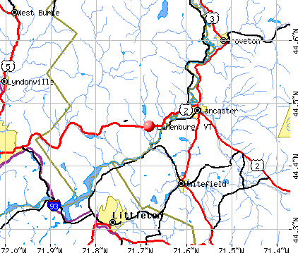
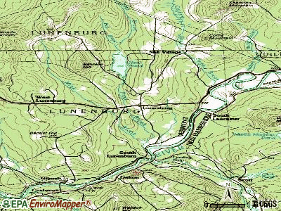
Lunenburg, Vermont
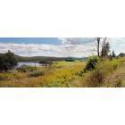
Lunenburg: Next to the Connecticut River on west bound Route 2 over-looking cornfield and the local foothills
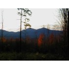
Lunenburg: Burke & Umprie mountians from Tug Mountian Rd.
- add
your
Submit your own pictures of this town and show them to the world
- OSM Map
- General Map
- Google Map
- MSN Map
Population change since 2000: -2.0%
 |
| Males: 659 | |
| Females: 643 |
| Median resident age: | 46.0 years |
| Vermont median age: | 45.8 years |
Zip codes: 05906.
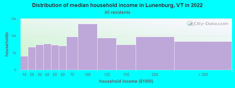
| Lunenburg: | $52,172 |
| VT: | $73,991 |
Estimated per capita income in 2022: $28,769 (it was $12,804 in 2000)
Lunenburg town income, earnings, and wages data
Estimated median house or condo value in 2022: $155,732 (it was $65,100 in 2000)
| Lunenburg: | $155,732 |
| VT: | $304,700 |
Detailed information about poverty and poor residents in Lunenburg, VT


- 1,26597.2%White alone
- 120.9%Hispanic
- 100.8%Two or more races
- 80.6%American Indian alone
- 40.3%Black alone
- 30.2%Asian alone
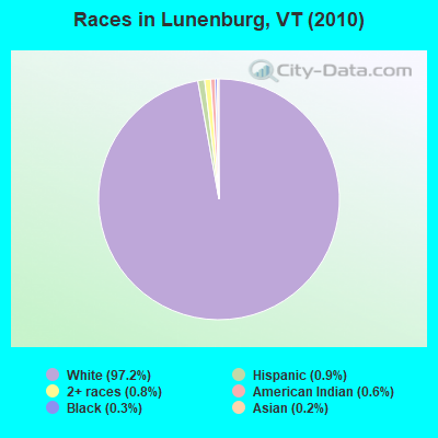
Races in Lunenburg detailed stats: ancestries, foreign born residents, place of birth
According to our research of Vermont and other state lists, there were 2 registered sex offenders living in Lunenburg, Vermont as of April 18, 2024.
The ratio of all residents to sex offenders in Lunenburg is 651 to 1.
The ratio of registered sex offenders to all residents in this city is lower than the state average.
 Recent articles from our blog. Our writers, many of them Ph.D. graduates or candidates, create easy-to-read articles on a wide variety of topics.

 | Vermont Weather (3778 replies) |
| VT just blew my away! (36 replies) |
| Where to live in Vermont? (29 year old married couple) (12 replies) |
| disincorporation of Town of Victory proposed (5 replies) |
| NEK vs. Northern NH (7 replies) |
| Lunenburg, VT (0 replies) |
Latest news from Lunenburg, VT collected exclusively by city-data.com from local newspapers, TV, and radio stations
Ancestries: English (37.1%), French (28.8%), Irish (16.5%), German (7.0%), Scottish (4.7%), Italian (3.3%).
Current Local Time: EST time zone
Elevation: 1202 feet
Land area: 45.1 square miles.
Population density: 29 people per square mile (very low).
38 residents are foreign born (1.3% North America, 0.7% Europe, 0.7% Asia).
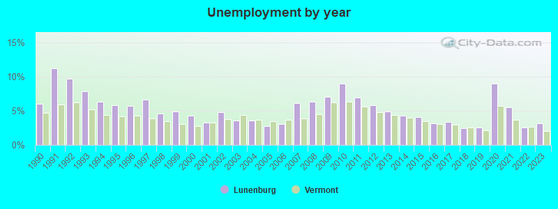
| This town: | 2.9% |
| Vermont: | 3.8% |
| Lunenburg town: | 1.6% ($1,058) |
| Vermont: | 2.0% ($2,196) |
Nearest city with pop. 50,000+: Portland, ME  (89.7 miles , pop. 64,249).
Nearest city with pop. 200,000+: Boston, MA (151.5 miles , pop. 589,141).
Nearest city with pop. 1,000,000+: Bronx, NY (274.0 miles , pop. 1,332,650).
Nearest cities:
), ), ), ), Latitude: 44.47 N, Longitude: 71.69 W
Area code: 802

| Here: | 3.2% |
| Vermont: | 2.0% |
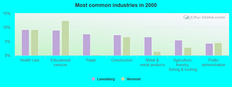
- Health care (9.2%)
- Educational services (9.0%)
- Paper (7.7%)
- Construction (7.3%)
- Metal & metal products (6.7%)
- Agriculture, forestry, fishing & hunting (5.5%)
- Public administration (4.3%)
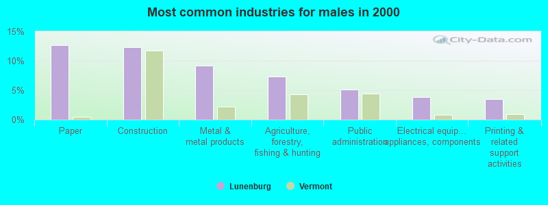
- Paper (12.7%)
- Construction (12.3%)
- Metal & metal products (9.2%)
- Agriculture, forestry, fishing & hunting (7.3%)
- Public administration (5.1%)
- Electrical equipment, appliances, components (3.8%)
- Printing & related support activities (3.5%)
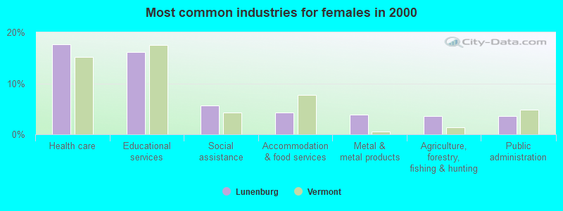
- Health care (17.6%)
- Educational services (16.2%)
- Social assistance (5.6%)
- Accommodation & food services (4.2%)
- Metal & metal products (3.9%)
- Agriculture, forestry, fishing & hunting (3.5%)
- Public administration (3.5%)
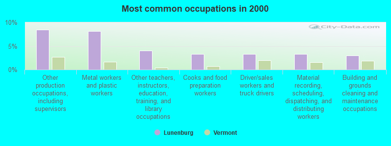
- Other production occupations, including supervisors (8.5%)
- Metal workers and plastic workers (8.2%)
- Other teachers, instructors, education, training, and library occupations (4.0%)
- Cooks and food preparation workers (3.3%)
- Driver/sales workers and truck drivers (3.3%)
- Material recording, scheduling, dispatching, and distributing workers (3.3%)
- Building and grounds cleaning and maintenance occupations (3.0%)
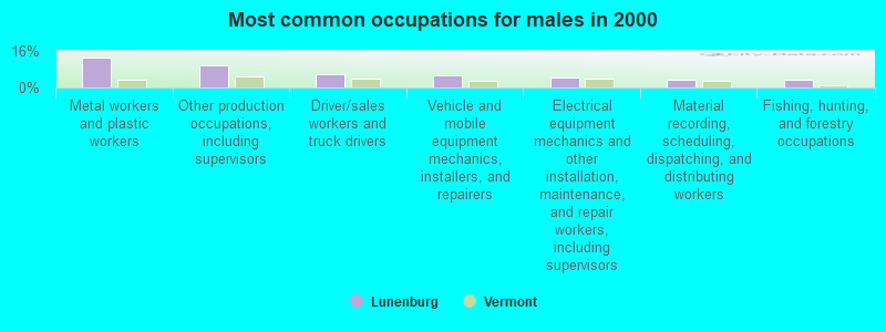
- Metal workers and plastic workers (13.0%)
- Other production occupations, including supervisors (9.8%)
- Driver/sales workers and truck drivers (6.0%)
- Vehicle and mobile equipment mechanics, installers, and repairers (5.4%)
- Electrical equipment mechanics and other installation, maintenance, and repair workers, including supervisors (4.4%)
- Material recording, scheduling, dispatching, and distributing workers (3.5%)
- Fishing, hunting, and forestry occupations (3.2%)
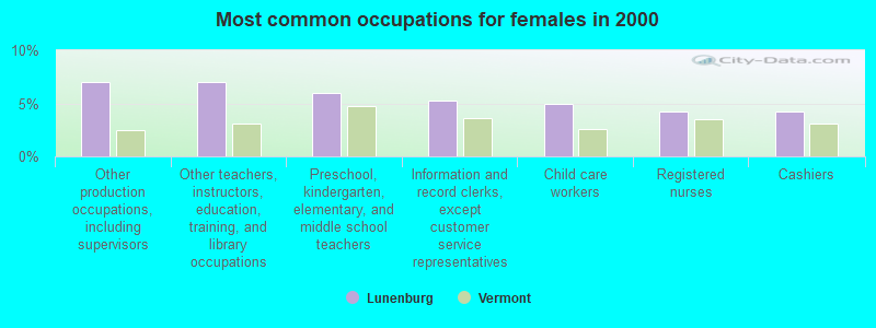
- Other production occupations, including supervisors (7.0%)
- Other teachers, instructors, education, training, and library occupations (7.0%)
- Preschool, kindergarten, elementary, and middle school teachers (6.0%)
- Information and record clerks, except customer service representatives (5.3%)
- Child care workers (4.9%)
- Registered nurses (4.2%)
- Cashiers (4.2%)
Average climate in Lunenburg, Vermont
Based on data reported by over 4,000 weather stations


(lower is better)
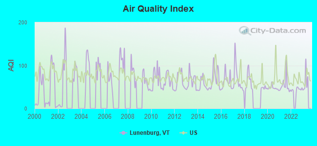
Air Quality Index (AQI) level in 2022 was 44.1. This is significantly better than average.
| City: | 44.1 |
| U.S.: | 72.6 |
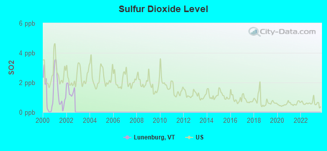
Sulfur Dioxide (SO2) [ppb] level in 2002 was 1.47. This is about average. Closest monitor was 12.3 miles away from the city center.
| City: | 1.47 |
| U.S.: | 1.51 |
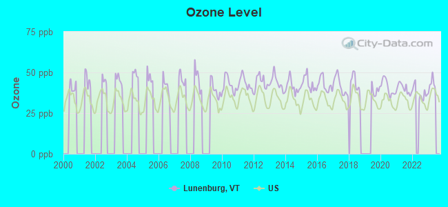
Ozone [ppb] level in 2022 was 37.5. This is about average. Closest monitor was 21.6 miles away from the city center.
| City: | 37.5 |
| U.S.: | 33.3 |
Earthquake activity:
Lunenburg-area historical earthquake activity is significantly above Vermont state average. It is 73% smaller than the overall U.S. average.On 4/20/2002 at 10:50:47, a magnitude 5.3 (5.3 ML, Depth: 3.0 mi, Class: Moderate, Intensity: VI - VII) earthquake occurred 99.2 miles away from the city center
On 4/20/2002 at 10:50:47, a magnitude 5.2 (5.2 MB, 4.2 MS, 5.2 MW, 5.0 MW) earthquake occurred 100.2 miles away from the city center
On 10/7/1983 at 10:18:46, a magnitude 5.3 (5.1 MB, 5.3 LG, 5.1 ML) earthquake occurred 136.3 miles away from the city center
On 1/19/1982 at 00:14:42, a magnitude 4.7 (4.5 MB, 4.7 MD, 4.5 LG, Class: Light, Intensity: IV - V) earthquake occurred 67.1 miles away from the city center
On 10/16/2012 at 23:12:25, a magnitude 4.7 (4.7 ML, Depth: 10.0 mi) earthquake occurred 79.1 miles away from Lunenburg center
On 6/16/1995 at 12:13:11, a magnitude 3.8 (3.8 LG, Depth: 3.1 mi, Class: Light, Intensity: II - III) earthquake occurred 16.9 miles away from Lunenburg center
Magnitude types: regional Lg-wave magnitude (LG), body-wave magnitude (MB), duration magnitude (MD), local magnitude (ML), surface-wave magnitude (MS), moment magnitude (MW)
Natural disasters:
The number of natural disasters in Essex County (20) is greater than the US average (15).Major Disasters (Presidential) Declared: 15
Emergencies Declared: 1
Causes of natural disasters: Floods: 14, Storms: 13, Tropical Storms: 2, Winter Storms: 2, Heavy Rain: 1, Hurricane: 1, Landslide: 1, Other: 1 (Note: some incidents may be assigned to more than one category).
Hospitals and medical centers near Lunenburg:
- MCKERLEY HEALTH CARE CENTER (Nursing Home, about 6 miles away; LANCASTER, NH)
- COUNTRY VILLAGE CENTER, GENESIS HEALTHCARE (Nursing Home, about 6 miles away; LANCASTER, NH)
- FRESENIUS MEDICAL CARE OF LANCASTER (Dialysis Facility, about 7 miles away; LANCASTER, NH)
- WEEKS MEDICAL CENTER Critical Access Hospitals (about 7 miles away; LANCASTER, NH)
- NORTHWOODS HOME HEALTH AND HOSPICE (Home Health Center, about 7 miles away; LANCASTER, NH)
- MORRISON NURSING HOME (Nursing Home, about 8 miles away; WHITEFIELD, NH)
- NORTH COUNTRY HOME HEALTH AND HOSPICE AGENCY (Home Health Center, about 13 miles away; LITTLETON, NH)
Colleges/universities with over 2000 students nearest to Lunenburg:
- Plymouth State University (about 50 miles; Plymouth, NH; Full-time enrollment: 4,838)
- Norwich University (about 54 miles; Northfield, VT; FT enrollment: 4,221)
- Dartmouth College (about 61 miles; Hanover, NH; FT enrollment: 6,030)
- Saint Michael's College (about 73 miles; Colchester, VT; FT enrollment: 2,336)
- Community College of Vermont (about 74 miles; Winooski, VT; FT enrollment: 3,394)
- Saint Joseph's College of Maine (about 75 miles; Standish, ME; FT enrollment: 2,010)
- University of Vermont (about 75 miles; Burlington, VT; FT enrollment: 11,566)
Points of interest:
Notable locations in Lunenburg: Alden Balch Memorial Library (A), Gilman Public Library (B), Lunenburg Fire Department (C), Lunenburg Fire Department - Gilman (D), Gilman - Lunenburg Fast Squad (E). Display/hide their locations on the map
Cemeteries: Stuart Cemetery (1), Spaulding Cemetery (2), Lunenburg Corner Cemetery (3), Clark Cemetery (4), Powers Cemetery (5), Riverside Cemetery (6), Baptist Hill Cemetery (7). Display/hide their locations on the map
Lakes and swamps: Neal Pond (A), Hastings Swamp (B). Display/hide their locations on the map
Streams, rivers, and creeks: Neal Brook (A), Hall Brook (B), Hudson Brook (C), Turner Brook (D). Display/hide their locations on the map
Drinking water stations with addresses in Lunenburg and their reported violations in the past:
LUNENBURG FIRE DISTRICT 2 (Address: 247 EAST MAIN STREET , Population served: 400, Groundwater):Past monitoring violations:LUNENBURG FIRE DISTRICT 1 (Population served: 250, Groundwater):
- Monitoring and Reporting (DBP) - Between JUL-2009 and SEP-2009, Contaminant: TTHM. Follow-up actions: St Public Notif requested (DEC-07-2009), St Tech Assistance Visit (DEC-07-2009), St Formal NOV issued (DEC-07-2009), St Public Notif received (APR-08-2010), St Compliance achieved (APR-26-2011)
- Monitoring and Reporting (DBP) - Between JUL-2009 and SEP-2009, Contaminant: Total Haloacetic Acids (HAA5). Follow-up actions: St Public Notif requested (DEC-07-2009), St Tech Assistance Visit (DEC-07-2009), St Formal NOV issued (DEC-07-2009), St Public Notif received (APR-08-2010), St Compliance achieved (APR-26-2011)
- Monitoring and Reporting (DBP) - Between OCT-2008 and DEC-2008, Contaminant: Chlorine. Follow-up actions: St Public Notif requested (APR-07-2009), St Formal NOV issued (APR-07-2009), St Public Notif received (SEP-29-2009), St Compliance achieved (MAR-08-2011)
- 2 regular monitoring violations
Past health violations:Past monitoring violations:
- MCL, Monthly (TCR) - In NOV-2011, Contaminant: Coliform. Follow-up actions: St Compliance achieved (DEC-28-2011), St Public Notif requested (JAN-05-2012), St Tech Assistance Visit (JAN-05-2012), St Boil Water Order (JAN-05-2012), St Formal NOV issued (JAN-05-2012)
- MCL, Monthly (TCR) - In JUN-2007, Contaminant: Coliform. Follow-up actions: St Tech Assistance Visit (JUN-21-2007), St Formal NOV issued (JUN-21-2007), St Boil Water Order (JUN-21-2007), St Public Notif requested (JUN-21-2007), St Public Notif received (JUN-26-2007), St Compliance achieved (2 times from SEP-25-2009 to OCT-06-2010)
- OCCT/SOWT Study/Recommendation - In JAN-01-2007, Contaminant: Lead and Copper Rule. Follow-up actions: St Public Notif received (MAY-07-2007), St Public Notif requested (MAY-09-2007), St Compliance achieved (NOV-04-2010)
- OCCT/SOWT Study/Recommendation - In OCT-01-2006, Contaminant: Lead and Copper Rule. Follow-up actions: St Compliance achieved (NOV-04-2010)
- Public Education - In JAN-01-2006, Contaminant: Lead and Copper Rule. Follow-up actions: St Public Notif requested (FEB-23-2006), St Formal NOV issued (FEB-23-2006), St Intentional no-action (JUN-30-2006), St Compliance achieved (JUN-13-2013)
- Monitoring and Reporting (DBP) - Between JUL-2008 and SEP-2008, Contaminant: Chlorine. Follow-up actions: St Public Notif received (MAR-17-2009), St Public Notif requested (APR-07-2009), St Formal NOV issued (APR-07-2009), St Compliance achieved (APR-27-2009)
- Monitoring and Reporting (DBP) - Between JAN-2005 and DEC-2005, Contaminant: Total Haloacetic Acids (HAA5). Follow-up actions: St Public Notif requested (JUN-26-2006), St Formal NOV issued (JUN-26-2006), St Public Notif received (JUN-30-2006)
- Monitoring and Reporting (DBP) - Between JAN-2005 and DEC-2005, Contaminant: TTHM. Follow-up actions: St Public Notif requested (JUN-26-2006), St Formal NOV issued (JUN-26-2006), St Public Notif received (JUN-30-2006)
- 4 routine major monitoring violations
- 12 regular monitoring violations
| This town: | 2.2 people |
| Vermont: | 2.3 people |
| This town: | 65.2% |
| Whole state: | 62.5% |
| This town: | 9.3% |
| Whole state: | 9.2% |
Likely homosexual households (counted as self-reported same-sex unmarried-partner households)
- Lesbian couples: 0.3% of all households
- Gay men: 0.5% of all households
| This town: | 12.6% |
| Whole state: | 9.4% |
| This town: | 2.9% |
| Whole state: | 3.6% |
For population 15 years and over in Lunenburg:
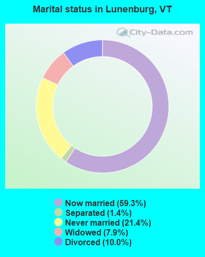
- Never married: 21.4%
- Now married: 59.3%
- Separated: 1.4%
- Widowed: 7.9%
- Divorced: 10.0%
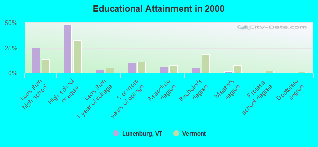
For population 25 years and over in Lunenburg:
- High school or higher: 74.7%
- Bachelor's degree or higher: 7.4%
- Graduate or professional degree: 1.9%
- Unemployed: 7.3%
- Mean travel time to work (commute): 24.6 minutes
| Here: | 10.1 |
| Vermont average: | 11.7 |
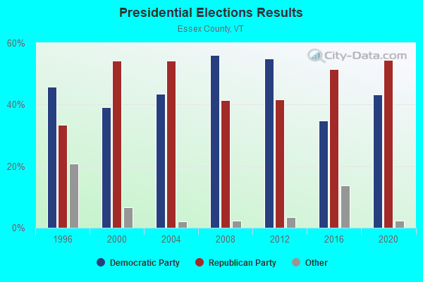
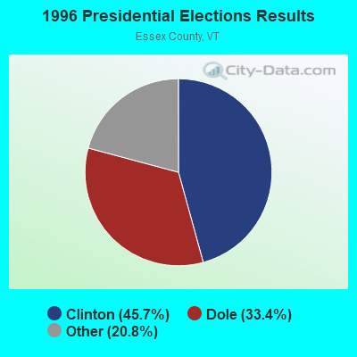
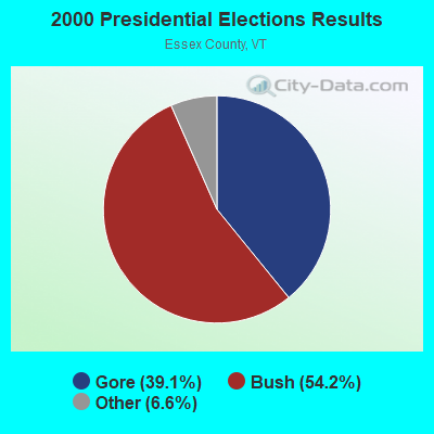
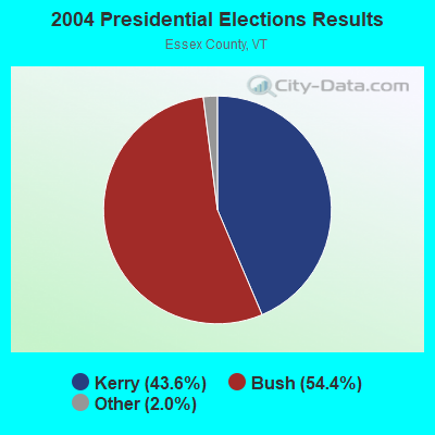
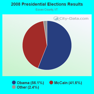

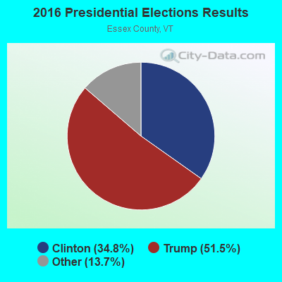
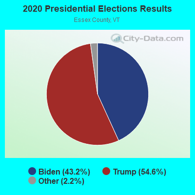
Graphs represent county-level data. Detailed 2008 Election Results
Religion statistics for Lunenburg, VT (based on Essex County data)
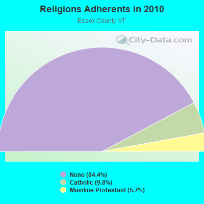
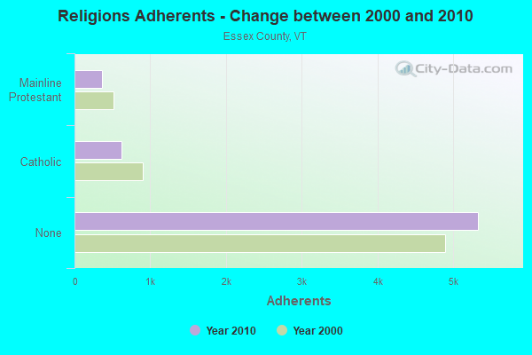
| Religion | Adherents | Congregations |
|---|---|---|
| Catholic | 619 | 2 |
| Mainline Protestant | 360 | 11 |
| Other | 3 | - |
| None | 5,324 | - |
Food Environment Statistics:
| Essex County: | 3.08 / 10,000 pop. |
| Vermont: | 3.84 / 10,000 pop. |
| Essex County: | 6.16 / 10,000 pop. |
| Vermont: | 6.40 / 10,000 pop. |
| Essex County: | 15.40 / 10,000 pop. |
| Vermont: | 11.52 / 10,000 pop. |
| Here: | 6.7% |
| State: | 6.8% |
| Essex County: | 25.1% |
| Vermont: | 22.3% |
| Here: | 11.3% |
| Vermont: | 13.3% |
Strongest AM radio stations in Lunenburg:
- WLTN (1400 AM; 1 kW; LITTLETON, NH; Owner: PROFILE BROADCASTING COMPANY, INC.)
- WTWN (1100 AM; daytime; 5 kW; WELLS RIVER, VT; Owner: PUFFER BROADCASTING, INC.)
- WCHP (760 AM; 35 kW; CHAMPLAIN, NY; Owner: CHAMPLAIN RADIO, INC.)
- WTME (780 AM; 10 kW; RUMFORD, ME; Owner: MOUNTAIN VALLEY BROADCASTING, INC.)
- WRKO (680 AM; 50 kW; BOSTON, MA; Owner: ENTERCOM BOSTON LICENSE, LLC)
- WSTJ (1340 AM; 1 kW; ST. JOHNSBURY, VT; Owner: VERMONT BROADCAST ASSOCIATES, INC.)
- WDEV (550 AM; 5 kW; WATERBURY, VT; Owner: RADIO VERMONT, INC.)
- WNNZ (640 AM; 50 kW; WESTFIELD, MA; Owner: CLEAR CHANNEL BROADCASTING LICENSES, INC.)
- WCRN (830 AM; 50 kW; WORCESTER, MA; Owner: CARTER BROADCASTING CORPORATION)
- WEEI (850 AM; 50 kW; BOSTON, MA; Owner: ENTERCOM BOSTON LICENSE, LLC)
- WGY (810 AM; 50 kW; SCHENECTADY, NY; Owner: CLEAR CHANNEL BROADCASTING LICENSES, INC.)
- WICY (1490 AM; 50 kW; MALONE, NY; Owner: CARTIER COMMUNICATIONS INC.)
- WBZ (1030 AM; 50 kW; BOSTON, MA; Owner: INFINITY BROADCASTING OPERATIONS, INC.)
Strongest FM radio stations in Lunenburg:
- WXXS (102.3 FM; LANCASTER, NH; Owner: BARRY P. LUNDERVILLE)
- WGMT (97.7 FM; LYNDON, VT; Owner: VERMONT BROADCAST ASSOCIATES, INC.)
- WMTK (106.3 FM; LITTLETON, NH; Owner: VERMONT BROADCAST ASSOCIATES, INC.)
- WPKQ (103.7 FM; NORTH CONWAY, NH; Owner: CITADEL BROADCASTING COMPANY)
- WHOM (94.9 FM; MT. WASHINGTON, NH; Owner: CITADEL BROADCASTING COMPANY)
- WCKJ (90.5 FM; ST. JOHNSBURY, VT; Owner: CHRISTIAN MINISTRIES, INC.)
- WKXH (105.5 FM; ST. JOHNSBURY, VT; Owner: VERMONT BROADCAST ASSOCIATES, INC.)
- WVFM (105.7 FM; CAMPTON, NH; Owner: DEVON BROADCASTING COMPANY, INC.)
- WDOT (95.7 FM; DANVILLE, VT; Owner: MONTPELIER BROADCASTING INC)
- WLKC (103.3 FM; WATERBURY, VT; Owner: RADIO BROADCASTING SERVICES, INC.)
- WVPS (107.9 FM; BURLINGTON, VT; Owner: VERMONT PUBLIC RADIO)
- WEZF (92.9 FM; BURLINGTON, VT; Owner: CAPSTAR TX LIMITED PARTNERSHIP)
- WCVT (101.7 FM; STOWE, VT; Owner: RADIO VERMONT CLASSICS, L.L.C.)
- WLTN-FM (96.7 FM; LISBON, NH; Owner: PROFILE BROADCASTING CO., INC.)
- WSCY (106.9 FM; MOULTONBOROUGH, NH; Owner: NORTHEAST COMMUNICATIONS CORPORATION)
- WNCS (104.7 FM; MONTPELIER, VT; Owner: MONTPELIER BROADCASTING, INC.)
- WDEV-FM (96.1 FM; WARREN, VT; Owner: RADIO VERMONT, INC.)
- WLOB-FM (96.3 FM; RUMFORD, ME; Owner: ATLANTIC COAST RADIO, LLC)
- W243AE (96.5 FM; ORLEANS, VT; Owner: CHRISTIAN MINISTRIES, INC.)
TV broadcast stations around Lunenburg:
- WLED-TV (Channel 49; LITTLETON, NH; Owner: UNIVERSITY OF NEW HAMPSHIRE)
- WVTB (Channel 20; ST. JOHNSBURY, VT; Owner: VERMONT ETV, INC.)
- Lunenburg, Vermont
- Fatal accident count18
- Vehicles involved in fatal accidents24
- Fatal accidents involving drunk persons:10
- Fatalities18
- Persons involved in fatal accidents38
- Pedestrians involved in fatal accidents1
- Vermont average
- Fatal accident count1189
- Vehicles involved in fatal accidents1641
- Fatal accidents involving drunk persons509
- Fatalities1353
- Persons involved in fatal accidents2997
- Pedestrians involved in fatal accidents42
- National Bridge Inventory (NBI) Statistics
- 4Number of bridges
- 92ft / 27.9mTotal length
- $6,704,000Total costs
- 2,372Total average daily traffic
- 156Total average daily truck traffic
- 3,222Total future (year 2027) average daily traffic
FCC Registered Antenna Towers:
4- Karl A Rinker, Top Of Mt. Tug, Near Temple Barway Road, Lunenburg, Vt (Lat: 44.515139 Lon: -71.729361), Type: 60.7, Overall height: 54.9 m, Registrant: Hill & Welch, Welchlaw@earthlink.Net, , Washi-ngton, Phone: (202) 775-0070
- Karl A Rinker, Top Of Mt. Tug, Near Temple Barway Road, Lunenburg, Vt (Lat: 44.515139 Lon: -71.729361), Type: 60.7, Overall height: 54.9 m, Registrant: Barre, Phone: (802) 479-0121
- F. Howard Mandel, Top Of Mt. Tug, Near Temple Barway Road, Lunenburg, Vt (Lat: 44.515139 Lon: -71.729361), Type: 60.7, Structure height: 50009 m, Overall height: 54.9 m, Registrant: K2 Towers, LLC, Hmandel@k2towers.Com, , Chagr-in Falls, Phone: (866) 962-0904
- Jake T Chapman, Top Of Mt. Tug, Near Temple Barway Road, Lunenburg, Vt (Lat: 44.515139 Lon: -71.729361), Type: 60.7, Structure height: 50009 m, Overall height: 54.9 m, Registrant: American Towers, LLC, Faa-Fcc@americantower.Com, , Wobur-n, Phone: (781) 926-4500
FCC Registered Broadcast Land Mobile Towers:
1- Station 2 Treatment Plant Road (Lat: 44.412222 Lon: -71.718333), Type: Mast, Structure height: 9 m, Overall height: 12 m, Call Sign: WPDZ370, Licensee ID: L00605564,
Assigned Frequencies: 154.370 MHz, Grant Date: 12/05/2013, Expiration Date: 01/07/2024, Cancellation Date: 03/09/2024, Registrant: Lunenburg, Town Of, Station 1 W. Main Street, Lunenburg, VT 05906, Phone: (802) 892-6611
FCC Registered Microwave Towers:
2- LUNENBURG, Top Of Mt. Tug, Near Temple Barway Road, Lunenburg, Vt (Lat: 44.515139 Lon: -71.729361), Type: Mtower, Structure height: 54.9 m, Overall height: 60.7 m, Call Sign: WQPL555,
Assigned Frequencies: 11445.0 MHz, 11445.0 MHz, 11445.0 MHz, 11445.0 MHz, 11445.0 MHz, 11445.0 MHz, 11445.0 MHz, 11445.0 MHz, 11445.0 MHz, 11445.0 MHz, Grant Date: 04/30/2022, Expiration Date: 06/20/2032, Certifier: Phil Chitwood, Registrant: Vermont Transco LLC., 366 Pinnacle Ridge Rd, Rutland, VT 05701, Phone: (802) 772-3777, Email:
- Lunenburg-01, Top Of Mt. Tug, Near Temple Barway Road, Lunenburg, Vt (Lat: 44.515139 Lon: -71.729361), Type: Ltower, Structure height: 54.9 m, Overall height: 60.7 m, Call Sign: WQWJ712,
Assigned Frequencies: 11385.0 MHz, 11545.0 MHz, 11385.0 MHz, 11545.0 MHz, 11385.0 MHz, 11545.0 MHz, 11385.0 MHz, 11545.0 MHz, 11385.0 MHz, 11545.0 MHz... (+14 more), Grant Date: 09/16/2015, Expiration Date: 09/16/2025, Certifier: Fran Stocker, Registrant: Radyn, Inc, Silver Spring, MD 20914, Phone: (301) 493-5171, Fax: (301) 576-4553, Email:
FCC Registered Amateur Radio Licenses:
5- Call Sign: KB1DZS, Grant Date: 04/23/1999, Expiration Date: 04/23/2009, Cancellation Date: 04/26/2011, Registrant: Laura V Wright, 110 Thomas Rd, Lunenburg, VT 05906
- Call Sign: N1ROD, Licensee ID: L00796684, Grant Date: 01/17/2024, Expiration Date: 04/11/2034, Certifier: Steven P Jones, Registrant: Steven P Jones, 400 Colby Rd, Lunenburg, VT 03584
- Call Sign: N1YBV, Grant Date: 11/04/1996, Expiration Date: 11/04/2006, Cancellation Date: 11/05/2008, Registrant: Luke A Colby, Rr1 Box 71, Lunenburg, VT 05906
- Call Sign: KB1SPP, Licensee ID: L00535868, Grant Date: 06/17/2009, Expiration Date: 06/17/2019, Cancellation Date: 06/18/2021, Certifier: Armand R Labbe, Registrant: Armand R Labbe, 1091 Pond Hill Rd, Lunenburg, VT 05906
- Call Sign: KB1YTV, Licensee ID: L01166349, Grant Date: 11/04/2022, Expiration Date: 11/04/2032, Certifier: Matthew C Heinmuller, Registrant: Matthew C Heinmuller, Lunenburg, VT 05906
2004 - 2018 National Fire Incident Reporting System (NFIRS) incidents
- Fire incident types reported to NFIRS in Lunenburg, VT
- 5652.8%Structure Fires
- 2523.6%Outside Fires
- 1312.3%Mobile Property/Vehicle Fires
- 1211.3%Other
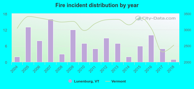 Based on the data from the years 2004 - 2018 the average number of fire incidents per year is 7. The highest number of fires - 16 took place in 2007, and the least - 1 in 2018. The data has a declining trend.
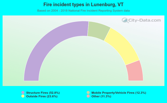 When looking into fire subcategories, the most reports belonged to: Structure Fires (52.8%), and Outside Fires (23.6%).
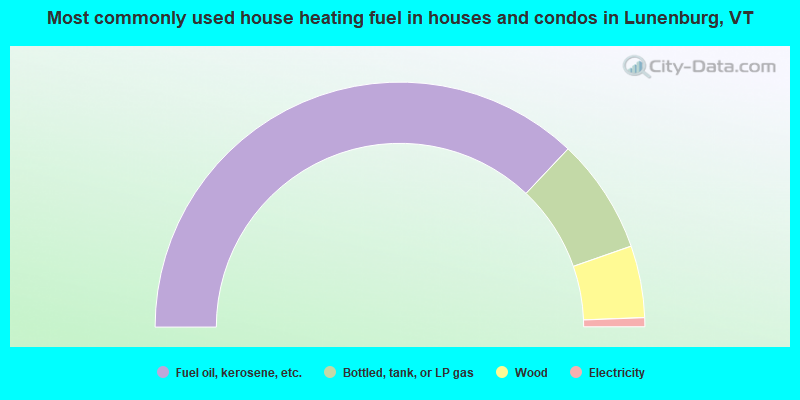
- 74.1%Fuel oil, kerosene, etc.
- 15.2%Bottled, tank, or LP gas
- 9.5%Wood
- 1.2%Electricity
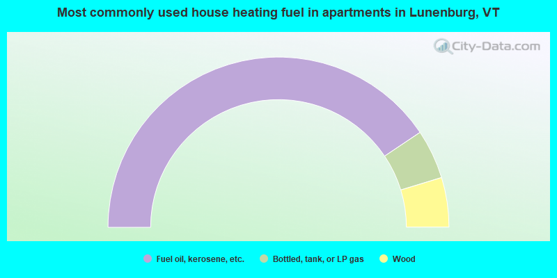
- 81.1%Fuel oil, kerosene, etc.
- 9.4%Bottled, tank, or LP gas
- 9.4%Wood
Lunenburg compared to Vermont state average:
- Median house value below state average.
- Unemployed percentage below state average.
- Black race population percentage significantly below state average.
- Hispanic race population percentage below state average.
- Foreign-born population percentage below state average.
- Length of stay since moving in significantly above state average.
- Number of rooms per house significantly below state average.
- House age significantly below state average.
- Number of college students significantly below state average.
- Percentage of population with a bachelor's degree or higher significantly below state average.