Newton, New Hampshire

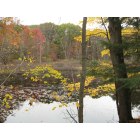
Newton: The Peanut Trail - A railroad bed, rails since removed to allow for open space.
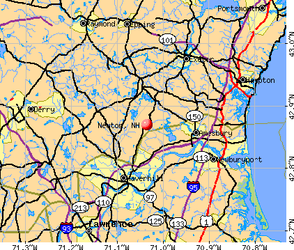
Newton: Peanut Trail - Reflecting Pond - Fall
- add
your
Submit your own pictures of this town and show them to the world
- OSM Map
- General Map
- Google Map
- MSN Map
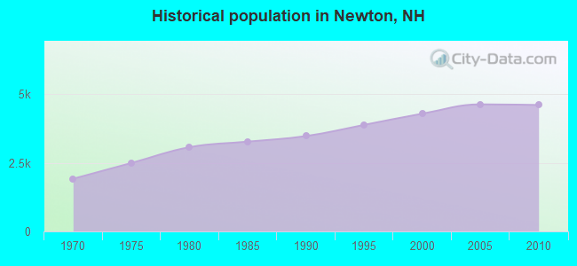
Population change since 2000: +7.3%
 |
| Males: 2,264 | |
| Females: 2,339 |
| Median resident age: | 40.4 years |
| New Hampshire median age: | 43.9 years |
Zip codes: 03858.
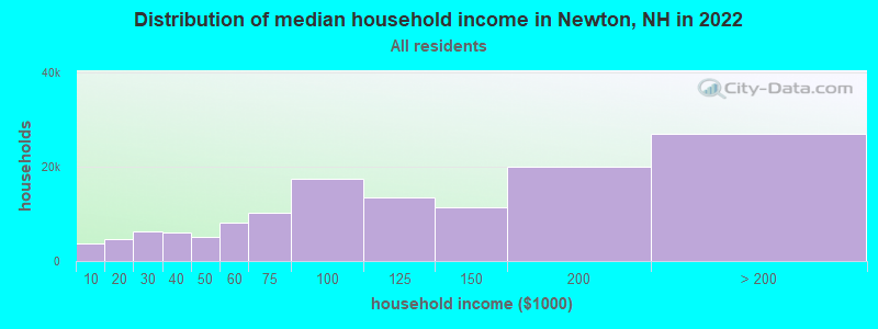
| Newton: | $112,656 |
| NH: | $89,992 |
Estimated per capita income in 2022: $50,290 (it was $22,910 in 2000)
Newton town income, earnings, and wages data
Estimated median house or condo value in 2022: $464,450 (it was $152,000 in 2000)
| Newton: | $464,450 |
| NH: | $384,700 |
Mean prices in 2022: all housing units: $614,227; detached houses: $665,470; townhouses or other attached units: $408,866; in 2-unit structures: $730,084; in 3-to-4-unit structures: over $1,000,000; in 5-or-more-unit structures: $329,099; mobile homes: $126,160
Detailed information about poverty and poor residents in Newton, NH


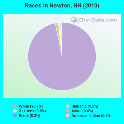
- 4,45396.7%White alone
- 671.5%Hispanic
- 370.8%Two or more races
- 190.4%Asian alone
- 120.3%Black alone
- 110.2%American Indian alone
- 40.09%Other race alone
Races in Newton detailed stats: ancestries, foreign born residents, place of birth
According to our research of New Hampshire and other state lists, there were 4 registered sex offenders living in Newton, New Hampshire as of April 23, 2024.
The ratio of all residents to sex offenders in Newton is 1,151 to 1.
The ratio of registered sex offenders to all residents in this city is lower than the state average.
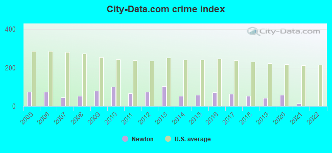
Type |
2009 |
2010 |
2011 |
2012 |
2013 |
2014 |
2015 |
2016 |
2017 |
2018 |
2019 |
2020 |
2021 |
2022 |
|---|---|---|---|---|---|---|---|---|---|---|---|---|---|---|
| Murders (per 100,000) | 0 (0.0) | 0 (0.0) | 0 (0.0) | 0 (0.0) | 0 (0.0) | 0 (0.0) | 0 (0.0) | 0 (0.0) | 0 (0.0) | 0 (0.0) | 0 (0.0) | 0 (0.0) | 0 (0.0) | 0 (0.0) |
| Rapes (per 100,000) | 2 (43.5) | 2 (43.4) | 1 (21.7) | 0 (0.0) | 1 (21.1) | 1 (20.9) | 1 (20.5) | 1 (20.3) | 2 (40.3) | 2 (40.0) | 2 (40.2) | 2 (40.2) | 0 (0.0) | 0 (0.0) |
| Robberies (per 100,000) | 0 (0.0) | 0 (0.0) | 0 (0.0) | 0 (0.0) | 1 (21.1) | 0 (0.0) | 0 (0.0) | 1 (20.3) | 0 (0.0) | 0 (0.0) | 0 (0.0) | 0 (0.0) | 0 (0.0) | 0 (0.0) |
| Assaults (per 100,000) | 0 (0.0) | 3 (65.2) | 1 (21.7) | 1 (21.6) | 7 (147.5) | 0 (0.0) | 2 (41.1) | 5 (101.5) | 3 (60.4) | 1 (20.0) | 0 (0.0) | 3 (60.4) | 1 (19.9) | 0 (0.0) |
| Burglaries (per 100,000) | 9 (195.9) | 13 (282.4) | 9 (195.3) | 11 (237.7) | 9 (189.6) | 9 (188.0) | 7 (143.8) | 6 (121.8) | 3 (60.4) | 2 (40.0) | 0 (0.0) | 4 (80.5) | 2 (39.8) | 0 (0.0) |
| Thefts (per 100,000) | 29 (631.3) | 37 (803.8) | 33 (716.0) | 58 (1,253) | 45 (948.0) | 23 (480.4) | 29 (595.8) | 19 (385.6) | 16 (322.4) | 15 (300.3) | 10 (201.1) | 7 (140.9) | 7 (139.2) | 0 (0.0) |
| Auto thefts (per 100,000) | 4 (87.1) | 1 (21.7) | 1 (21.7) | 2 (43.2) | 0 (0.0) | 3 (62.7) | 0 (0.0) | 3 (60.9) | 1 (20.1) | 2 (40.0) | 1 (20.1) | 2 (40.2) | 1 (19.9) | 0 (0.0) |
| Arson (per 100,000) | 0 (0.0) | 1 (21.7) | 0 (0.0) | 0 (0.0) | 1 (21.1) | 0 (0.0) | 0 (0.0) | 1 (20.3) | 1 (20.1) | 0 (0.0) | 0 (0.0) | 0 (0.0) | 0 (0.0) | 0 (0.0) |
| City-Data.com crime index | 80.8 | 101.5 | 65.7 | 74.5 | 103.9 | 54.1 | 58.6 | 71.4 | 63.1 | 54.1 | 41.8 | 58.8 | 13.9 | 0.0 |
The City-Data.com crime index weighs serious crimes and violent crimes more heavily. Higher means more crime, U.S. average is 246.1. It adjusts for the number of visitors and daily workers commuting into cities.
Crime rate in Newton detailed stats: murders, rapes, robberies, assaults, burglaries, thefts, arson
Full-time law enforcement employees in 2021, including police officers: 8 (7 officers - 7 male; 0 female).
| Officers per 1,000 residents here: | 1.39 |
| New Hampshire average: | 2.14 |
 Recent articles from our blog. Our writers, many of them Ph.D. graduates or candidates, create easy-to-read articles on a wide variety of topics.

 | What if NH Had a Flat Income Tax Like PA? (118 replies) |
| Low density housing is killing nh! (67 replies) |
| Yet Another Guy Looking to Relocate to Southern NH (27 replies) |
| should I move from Los Angeles to New Hampshire? (42 replies) |
| Newton NH have good town management (0 replies) |
| Moving from Va to NH looking for some advice :) (32 replies) |
Latest news from Newton, NH collected exclusively by city-data.com from local newspapers, TV, and radio stations
Ancestries: Irish (21.5%), English (21.1%), French (14.8%), Italian (14.5%), French Canadian (7.2%), German (6.2%).
Current Local Time: EST time zone
Incorporated in 1749
Elevation: 200 feet
Land area: 9.91 square miles.
Population density: 465 people per square mile (low).
108 residents are foreign born (1.7% Europe, 0.6% North America).
| This town: | 2.5% |
| New Hampshire: | 4.4% |
| Newton town: | 2.2% ($3,279) |
| New Hampshire: | 2.3% ($2,946) |
Nearest city with pop. 50,000+: Haverhill, MA  (6.7 miles , pop. 58,969).
Nearest city with pop. 200,000+: Boston, MA (38.1 miles , pop. 589,141).
Nearest city with pop. 1,000,000+: Bronx, NY (201.9 miles , pop. 1,332,650).
Nearest cities:
), ), ), ), Latitude: 42.87 N, Longitude: 71.05 W
Area code commonly used in this area: 603

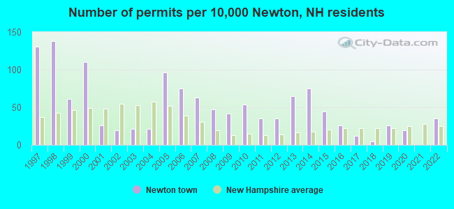
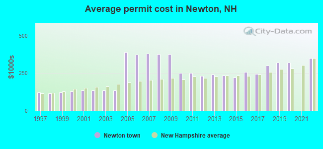
Single-family new house construction building permits:
- 2022: 15 buildings, average cost: $349,400
- 2020: 8 buildings, average cost: $320,000
- 2019: 11 buildings, average cost: $320,000
- 2018: 2 buildings, average cost: $300,000
- 2017: 5 buildings, average cost: $246,000
- 2016: 11 buildings, average cost: $256,800
- 2015: 19 buildings, average cost: $221,300
- 2014: 32 buildings, average cost: $235,600
- 2013: 28 buildings, average cost: $241,100
- 2012: 15 buildings, average cost: $232,500
- 2011: 15 buildings, average cost: $250,400
- 2010: 23 buildings, average cost: $250,000
- 2009: 18 buildings, average cost: $377,400
- 2008: 20 buildings, average cost: $377,200
- 2007: 27 buildings, average cost: $378,500
- 2006: 32 buildings, average cost: $374,300
- 2005: 41 buildings, average cost: $390,200
- 2004: 9 buildings, average cost: $135,900
- 2003: 9 buildings, average cost: $135,900
- 2002: 8 buildings, average cost: $135,900
- 2001: 11 buildings, average cost: $135,900
- 2000: 47 buildings, average cost: $128,400
- 1999: 26 buildings, average cost: $122,200
- 1998: 59 buildings, average cost: $116,400
- 1997: 56 buildings, average cost: $122,800
| Here: | 2.9% |
| New Hampshire: | 2.5% |
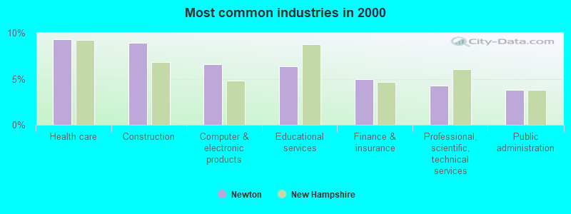
- Health care (9.3%)
- Construction (8.9%)
- Computer & electronic products (6.6%)
- Educational services (6.4%)
- Finance & insurance (5.0%)
- Professional, scientific, technical services (4.2%)
- Public administration (3.8%)
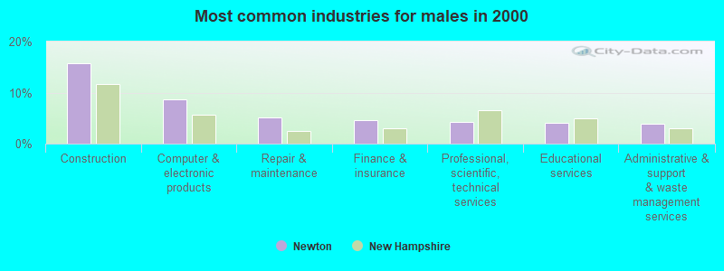
- Construction (15.7%)
- Computer & electronic products (8.7%)
- Repair & maintenance (5.1%)
- Finance & insurance (4.6%)
- Professional, scientific, technical services (4.2%)
- Educational services (4.1%)
- Administrative & support & waste management services (3.9%)
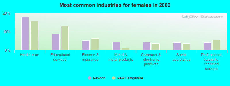
- Health care (18.1%)
- Educational services (8.9%)
- Finance & insurance (5.3%)
- Metal & metal products (4.5%)
- Computer & electronic products (4.3%)
- Social assistance (4.2%)
- Professional, scientific, technical services (4.2%)
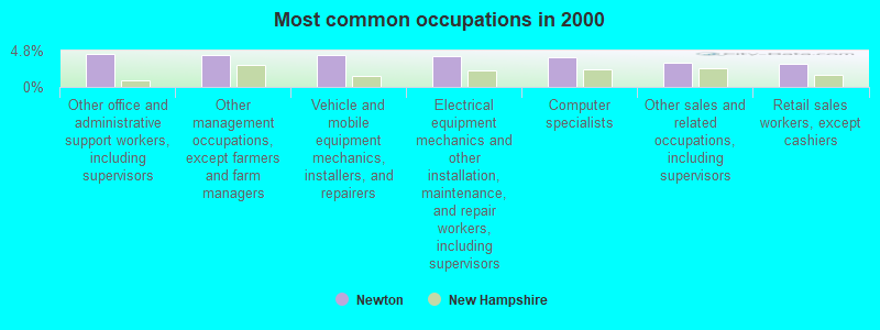
- Other office and administrative support workers, including supervisors (4.3%)
- Other management occupations, except farmers and farm managers (4.2%)
- Vehicle and mobile equipment mechanics, installers, and repairers (4.2%)
- Electrical equipment mechanics and other installation, maintenance, and repair workers, including supervisors (4.1%)
- Computer specialists (3.9%)
- Other sales and related occupations, including supervisors (3.2%)
- Retail sales workers, except cashiers (3.1%)
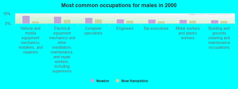
- Vehicle and mobile equipment mechanics, installers, and repairers (8.1%)
- Electrical equipment mechanics and other installation, maintenance, and repair workers, including supervisors (7.2%)
- Computer specialists (6.2%)
- Engineers (4.5%)
- Top executives (4.2%)
- Metal workers and plastic workers (4.1%)
- Building and grounds cleaning and maintenance occupations (3.8%)
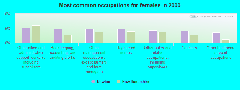
- Other office and administrative support workers, including supervisors (5.3%)
- Bookkeeping, accounting, and auditing clerks (5.0%)
- Other management occupations, except farmers and farm managers (4.9%)
- Registered nurses (4.7%)
- Other sales and related occupations, including supervisors (4.3%)
- Cashiers (4.2%)
- Other healthcare support occupations (3.6%)
Average climate in Newton, New Hampshire
Based on data reported by over 4,000 weather stations


(lower is better)
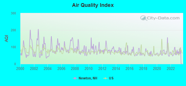
Air Quality Index (AQI) level in 2022 was 66.4. This is about average.
| City: | 66.4 |
| U.S.: | 72.6 |
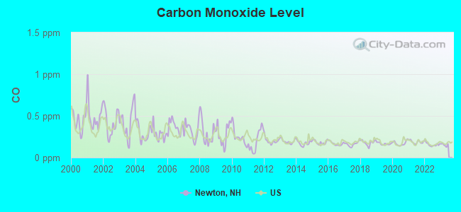
Carbon Monoxide (CO) [ppm] level in 2022 was 0.157. This is significantly better than average. Closest monitor was 16.8 miles away from the city center.
| City: | 0.157 |
| U.S.: | 0.251 |
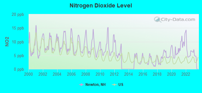
Nitrogen Dioxide (NO2) [ppb] level in 2022 was 6.45. This is worse than average. Closest monitor was 6.6 miles away from the city center.
| City: | 6.45 |
| U.S.: | 5.11 |
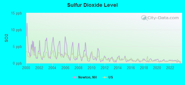
Sulfur Dioxide (SO2) [ppb] level in 2022 was 0.806. This is significantly better than average. Closest monitor was 6.6 miles away from the city center.
| City: | 0.806 |
| U.S.: | 1.515 |
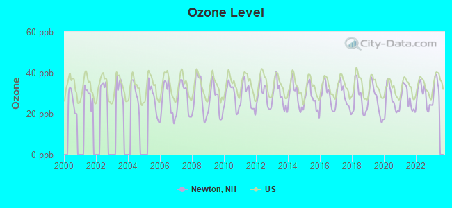
Ozone [ppb] level in 2022 was 28.8. This is about average. Closest monitor was 6.6 miles away from the city center.
| City: | 28.8 |
| U.S.: | 33.3 |
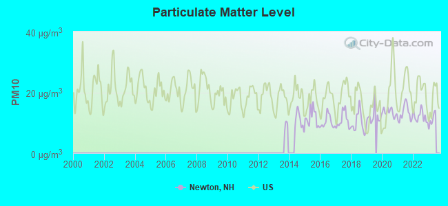
Particulate Matter (PM10) [µg/m3] level in 2022 was 12.1. This is significantly better than average. Closest monitor was 12.2 miles away from the city center.
| City: | 12.1 |
| U.S.: | 19.2 |
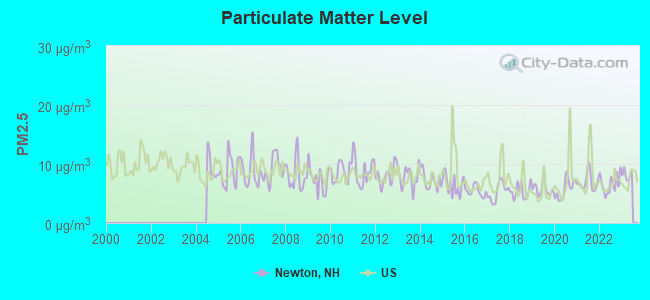
Particulate Matter (PM2.5) [µg/m3] level in 2022 was 6.64. This is better than average. Closest monitor was 7.5 miles away from the city center.
| City: | 6.64 |
| U.S.: | 8.11 |
Tornado activity:
Newton-area historical tornado activity is slightly above New Hampshire state average. It is 45% smaller than the overall U.S. average.
On 6/9/1953, a category F3 (max. wind speeds 158-206 mph) tornado 7.9 miles away from the Newton town center injured 5 people and caused between $5000 and $50,000 in damages.
On 9/29/1974, a category F3 tornado 19.0 miles away from the town center injured one person and caused between $50,000 and $500,000 in damages.
Earthquake activity:
Newton-area historical earthquake activity is significantly above New Hampshire state average. It is 73% smaller than the overall U.S. average.On 4/20/2002 at 10:50:47, a magnitude 5.3 (5.3 ML, Depth: 3.0 mi, Class: Moderate, Intensity: VI - VII) earthquake occurred 174.4 miles away from Newton center
On 1/19/1982 at 00:14:42, a magnitude 4.7 (4.5 MB, 4.7 MD, 4.5 LG, Class: Light, Intensity: IV - V) earthquake occurred 51.6 miles away from Newton center
On 10/16/2012 at 23:12:25, a magnitude 4.7 (4.7 ML, Depth: 10.0 mi) earthquake occurred 54.0 miles away from the city center
On 10/7/1983 at 10:18:46, a magnitude 5.3 (5.1 MB, 5.3 LG, 5.1 ML) earthquake occurred 181.6 miles away from the city center
On 4/20/2002 at 10:50:47, a magnitude 5.2 (5.2 MB, 4.2 MS, 5.2 MW, 5.0 MW) earthquake occurred 174.1 miles away from Newton center
On 8/22/1992 at 12:20:32, a magnitude 4.8 (4.8 MB, 3.8 MS, 4.7 LG, Depth: 6.2 mi) earthquake occurred 263.2 miles away from the city center
Magnitude types: regional Lg-wave magnitude (LG), body-wave magnitude (MB), duration magnitude (MD), local magnitude (ML), surface-wave magnitude (MS), moment magnitude (MW)
Natural disasters:
The number of natural disasters in Rockingham County (26) is a lot greater than the US average (15).Major Disasters (Presidential) Declared: 17
Emergencies Declared: 9
Causes of natural disasters: Storms: 12, Floods: 9, Winter Storms: 5, Hurricanes: 4, Snowstorms: 4, Snows: 2, Winds: 2, Blizzard: 1, Snowfall: 1, Tornado: 1 (Note: some incidents may be assigned to more than one category).
Hospitals and medical centers near Newton:
- EXCELLA HOMECARE INC (Home Health Center, about 5 miles away; AMESBURY, MA)
- LENOX NH INC (Nursing Home, about 5 miles away; HAVERHILL, MA)
- LAKEVIEW HOUSE NH (Nursing Home, about 6 miles away; HAVERHILL, MA)
- LAKEVIEW HOUSE SKLD NRSG AND RESIDENTIAL CARE FAC (Nursing Home, about 6 miles away; HAVERHILL, MA)
- KENOZA HILLCREST NURSING HOME (Nursing Home, about 6 miles away; HAVERHILL, MA)
- HAMPSTEAD HOSP (Hospital, about 6 miles away; HAMPSTEAD, NH)
- KENOZA MANOR CONV HOME (Nursing Home, about 6 miles away; HAVERHILL, MA)
Operable nuclear power plant near Newton:
- 10 miles: Seabrook in Seabrook, NH.
Colleges/universities with over 2000 students nearest to Newton:
- Northern Essex Community College (about 6 miles; Haverhill, MA; Full-time enrollment: 4,737)
- Merrimack College (about 15 miles; North Andover, MA; FT enrollment: 2,734)
- University of New Hampshire-Main Campus (about 20 miles; Durham, NH; FT enrollment: 15,243)
- North Shore Community College (about 20 miles; Danvers, MA; FT enrollment: 5,195)
- University of Massachusetts-Lowell (about 21 miles; Lowell, MA; FT enrollment: 12,341)
- Mount Washington College (about 23 miles; Manchester, NH; FT enrollment: 2,187)
- Southern New Hampshire University (about 24 miles; Manchester, NH; FT enrollment: 16,552)
Public elementary/middle schools in Newton:
- SANBORN REGIONAL MIDDLE SCHOOL (Students: 409, Location: 31A WEST MAIN ST., Grades: 6-8)
- MEMORIAL SCHOOL (Students: 343, Location: 31 W. MAIN ST., Grades: PK-5)
Points of interest:
Notable locations in Newton: Indian Mound Ski Area (A), Gale Library (B), Newton Fire Department (C). Display/hide their locations on the map
Churches in Newton include: First Baptist Church (A), First Christian Church (B), Free Will Baptist Meeting House (C), Mary Mother of the Church Roman Catholic Church (D). Display/hide their locations on the map
Cemeteries: Willow Grove Cemetery (1), Old Town Cemetery (2), Highland Cemetery (3), Union Cemetery (4). Display/hide their locations on the map
Park in Newton: Richard Sargent Management Area (1). Display/hide its location on the map
Drinking water stations with addresses in Newton and their reported violations in the past:
ROUTE 108 GENERAL STORE (Population served: 48, Groundwater):Past health violations:Past monitoring violations:
- MCL, Monthly (TCR) - Between OCT-2006 and DEC-2006, Contaminant: Coliform. Follow-up actions: St Public Notif requested (DEC-01-2006), St Violation/Reminder Notice (DEC-01-2006), St Public Notif received (DEC-20-2006), St Compliance achieved (MAY-31-2007)
- MCL, Monthly (TCR) - Between JUL-2006 and SEP-2006, Contaminant: Coliform. Follow-up actions: St Public Notif requested (SEP-08-2006), St Violation/Reminder Notice (SEP-08-2006), St Public Notif received (SEP-14-2006), St Formal NOV issued (SEP-18-2006), St Compliance achieved (MAY-31-2007)
- MCL, Monthly (TCR) - Between APR-2006 and JUN-2006, Contaminant: Coliform. Follow-up actions: St Public Notif requested (JUN-30-2006), St Violation/Reminder Notice (JUN-30-2006), St Public Notif received (SEP-07-2006), St Formal NOV issued (SEP-18-2006), St Compliance achieved (MAY-31-2007)
- One routine major monitoring violation
- One regular monitoring violation
Drinking water stations with addresses in Newton that have no violations reported:
- WHISPERING PINES CAMPGROUND (Population served: 100, Primary Water Source Type: Groundwater)
- WILLOWBROOKE MALL (Population served: 60, Primary Water Source Type: Groundwater)
| This town: | 2.8 people |
| New Hampshire: | 2.5 people |
| This town: | 75.4% |
| Whole state: | 66.3% |
| This town: | 6.7% |
| Whole state: | 8.3% |
Likely homosexual households (counted as self-reported same-sex unmarried-partner households)
- Lesbian couples: 0.8% of all households
- Gay men: 0.1% of all households
| This town: | 4.0% |
| Whole state: | 6.5% |
| This town: | 2.7% |
| Whole state: | 2.8% |
Banks with branches in Newton (2011 data):
- Merrimac Savings Bank: Newton Nh Branch at 29 South Main Street, branch established on 2004/12/15. Info updated 2006/10/23: Bank assets: $63.4 mil, Deposits: $56.2 mil, headquarters in Merrimac, MA, positive income, Mortgage Lending Specialization, 2 total offices
For population 15 years and over in Newton:
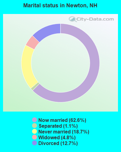
- Never married: 18.7%
- Now married: 62.6%
- Separated: 1.1%
- Widowed: 4.8%
- Divorced: 12.7%
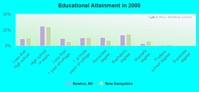
For population 25 years and over in Newton:
- High school or higher: 89.0%
- Bachelor's degree or higher: 21.3%
- Graduate or professional degree: 4.6%
- Unemployed: 1.7%
- Mean travel time to work (commute): 31.6 minutes
| Here: | 8.8 |
| New Hampshire average: | 10.9 |


Graphs represent county-level data. Detailed 2008 Election Results
Religion statistics for Newton, NH (based on Rockingham County data)


| Religion | Adherents | Congregations |
|---|---|---|
| Catholic | 84,697 | 24 |
| Mainline Protestant | 19,072 | 78 |
| Evangelical Protestant | 7,456 | 61 |
| Other | 3,490 | 20 |
| Orthodox | 200 | 1 |
| None | 180,308 | - |
Food Environment Statistics:
| Here: | 1.59 / 10,000 pop. |
| New Hampshire: | 2.14 / 10,000 pop. |
| Here: | 0.17 / 10,000 pop. |
| New Hampshire: | 0.15 / 10,000 pop. |
| Rockingham County: | 1.86 / 10,000 pop. |
| State: | 1.78 / 10,000 pop. |
| Rockingham County: | 3.31 / 10,000 pop. |
| New Hampshire: | 4.02 / 10,000 pop. |
| Rockingham County: | 9.56 / 10,000 pop. |
| New Hampshire: | 9.70 / 10,000 pop. |
| Rockingham County: | 7.6% |
| New Hampshire: | 7.6% |
| Here: | 23.3% |
| New Hampshire: | 24.4% |
| Rockingham County: | 16.8% |
| New Hampshire: | 15.9% |
7.69% of this county's 2021 resident taxpayers lived in other counties in 2020 ($114,534 average adjusted gross income)
| Here: | 7.69% |
| New Hampshire average: | 7.66% |
0.01% of residents moved from foreign countries ($203 average AGI)
Rockingham County: 0.01% New Hampshire average: 0.01%
Top counties from which taxpayers relocated into this county between 2020 and 2021:
| from Essex County, MA | |
| from Hillsborough County, NH | |
| from Middlesex County, MA |
6.82% of this county's 2020 resident taxpayers moved to other counties in 2021 ($88,778 average adjusted gross income)
| Here: | 6.82% |
| New Hampshire average: | 6.80% |
0.01% of residents moved to foreign countries ($126 average AGI)
Rockingham County: 0.01% New Hampshire average: 0.01%
Top counties to which taxpayers relocated from this county between 2020 and 2021:
| to Hillsborough County, NH | |
| to Strafford County, NH | |
| to Essex County, MA |
Strongest AM radio stations in Newton:
- WRKO (680 AM; 50 kW; BOSTON, MA; Owner: ENTERCOM BOSTON LICENSE, LLC)
- WDER (1320 AM; 10 kW; DERRY, NH; Owner: BLOUNT COMMUNICATIONS, INC. OF NH)
- WGIP (1540 AM; 5 kW; EXETER, NH; Owner: CAPSTAR TX LIMITED PARTNERSHIP)
- WEEI (850 AM; 50 kW; BOSTON, MA; Owner: ENTERCOM BOSTON LICENSE, LLC)
- WWZN (1510 AM; 50 kW; BOSTON, MA; Owner: ROSE CITY RADIO CORPORATION)
- WBZ (1030 AM; 50 kW; BOSTON, MA; Owner: INFINITY BROADCASTING OPERATIONS, INC.)
- WCEC (1110 AM; daytime; 5 kW; SALEM, NH; Owner: COSTA-EAGLE RADIO VENTURES LTD PARTNERSHIP)
- WKOX (1200 AM; 50 kW; FRAMINGHAM, MA; Owner: CAPSTAR TX LIMITED PARTNERSHIP)
- WBIX (1060 AM; 40 kW; NATICK, MA; Owner: LANGER BROADCASTING CORPORATION)
- WCRN (830 AM; 50 kW; WORCESTER, MA; Owner: CARTER BROADCASTING CORPORATION)
- WRCA (1330 AM; 25 kW; WALTHAM, MA; Owner: WRCA LICENSE, LLC)
- WGIR (610 AM; 5 kW; MANCHESTER, NH; Owner: CAPSTAR TX LIMITED PARTNERSHIP)
- WCCM (1490 AM; 1 kW; HAVERHILL, MA; Owner: COSTA-EAGLE RADIO VENTURES LTD P/SHI)
Strongest FM radio stations in Newton:
- WXRV (92.5 FM; HAVERHILL, MA; Owner: BEANPOT BROADCASTING CORP.)
- WNEF (91.7 FM; NEWBURYPORT, MA; Owner: UNIVERSITY OF MASSACHUSETTS)
- WSAK (102.1 FM; HAMPTON, NH; Owner: CITADEL BROADCASTING COMPANY)
- WKLB-FM (99.5 FM; LOWELL, MA; Owner: GREATER BOSTON RADIO, INC.)
- W227AM (93.3 FM; ANDOVER, MA; Owner: GREATER BOSTON RADIO, INC.)
- WGIR-FM (101.1 FM; MANCHESTER, NH; Owner: CAPSTAR TX LIMITED PARTNERSHIP)
- WQLL (96.5 FM; BEDFORD, NH; Owner: SAGA COMMUNICATIONS OF NEW ENGLAND, LLC)
- WLMW (90.7 FM; MANCHESTER, NH; Owner: KNOWLEDGE FOR LIFE)
- WERZ (107.1 FM; EXETER, NH; Owner: CAPSTAR TX LIMITED PARTNERSHIP)
- WZID (95.7 FM; MANCHESTER, NH; Owner: SAGA COMMUNICATIONS OF NEW ENGLAND, LLC)
- WHOB (106.3 FM; NASHUA, NH; Owner: TELE-MEDIA COMPANY OF NEW HAMPSHIRE, L.L.C.)
- WXKS-FM (107.9 FM; MEDFORD, MA; Owner: AMFM RADIO LICENSES, L.L.C.)
- WMJX (106.7 FM; BOSTON, MA; Owner: GREATER BOSTON RADIO, INC.)
- WFEX (92.1 FM; PETERBOROUGH, NH; Owner: FNX BROADCASTING OF NEW HAMPSHIRE LLC)
- WQSX (93.7 FM; LAWRENCE, MA; Owner: ENTERCOM BOSTON LICENSE, LLC)
- WHEB (100.3 FM; PORTSMOUTH, NH; Owner: CAPSTAR TX LIMITED PARTNERSHIP)
- WBMX (98.5 FM; BOSTON, MA; Owner: INFINITY RADIO OPERATIONS INC.)
- WJMN (94.5 FM; BOSTON, MA; Owner: AMFM RADIO LICENSES, L.L.C.)
- WCRB (102.5 FM; WALTHAM, MA; Owner: CHARLES RIVER BROADCASTING WCRB LICE)
- WTKK (96.9 FM; BOSTON, MA; Owner: GREATER BOSTON RADIO, INC.)
TV broadcast stations around Newton:
- WHDN-LP (Channel 26; BOSTON, MA; Owner: GUENTER MARKSTEINER)
- WFXZ-CA (Channel 24; BOSTON, MA; Owner: BOSTON BROADCASTING CORP.)
- WCVB-TV (Channel 5; BOSTON, MA; Owner: WCVB HEARST-ARGYLE TV, INC.)
- WMEA-TV (Channel 26; BIDDEFORD, ME; Owner: MAINE PUBLIC BROADCASTING CORP.)
- WGBH-TV (Channel 2; BOSTON, MA; Owner: WGBH EDUCATIONAL FOUNDATION)
- WHDH-TV (Channel 7; BOSTON, MA; Owner: WHDH-TV)
- WMFP (Channel 62; LAWRENCE, MA; Owner: WSAH LICENSE, INC.)
- WSBK-TV (Channel 38; BOSTON, MA; Owner: VIACOM INC.)
- WBZ-TV (Channel 4; BOSTON, MA; Owner: VIACOM INC.)
- WGBX-TV (Channel 44; BOSTON, MA; Owner: WGBH EDUCATIONAL FOUNDATION)
- WLVI-TV (Channel 56; CAMBRIDGE, MA; Owner: WLVI, INC.)
- WNDS (Channel 50; DERRY, NH; Owner: CTV OF DERRY, INC)
- WUTF (Channel 66; MARLBOROUGH, MA; Owner: TELEFUTURA BOSTON LLC)
- WENH-TV (Channel 11; DURHAM, NH; Owner: UNIVERSITY OF NEW HAMPSHIRE)
- WFXT (Channel 25; BOSTON, MA; Owner: FOX TELEVISION STATIONS INC.)
- WBPX (Channel 68; BOSTON, MA; Owner: PAXSON BOSTON-68 LICENSE, INC.)
- WUNI (Channel 27; WORCESTER, MA; Owner: ENTRAVISION HOLDINGS, LLC)
- WTMU-LP (Channel 32; BOSTON, MA; Owner: ZGS BOSTON, INC.)
- WCEA-LP (Channel 58; BOSTON, MA; Owner: CHANNEL 19 TV CORPORATION)
- W40BO (Channel 40; BOSTON, MA; Owner: PAXSON COMMUNICATIONS LPTV, INC.)
- National Bridge Inventory (NBI) Statistics
- 4Number of bridges
- 56ft / 17.5mTotal length
- $12,568,000Total costs
- 22,748Total average daily traffic
- 1,177Total average daily truck traffic
- 33,664Total future (year 2042) average daily traffic
FCC Registered Broadcast Land Mobile Towers:
4- Fire Station Rt 108 (Lat: 42.865361 Lon: -71.039500), Type: Building, Structure height: 14 m, Call Sign: KSU379,
Assigned Frequencies: 154.010 MHz, 154.145 MHz, 154.160 MHz, 154.190 MHz, Grant Date: 07/14/2023, Expiration Date: 07/20/2033, Registrant: Cara Enterprises, Inc, 30251 Golden Lanter Suite E #501, Las Vegas, NV 89140-0124, Phone: (702) 838-9728, Fax: (702) 363-4607, Email:
- Newton Police Dept Main St (Lat: 42.883694 Lon: -71.017000), Call Sign: KXM843,
Assigned Frequencies: 155.475 MHz, 156.090 MHz, Grant Date: 04/27/2022, Expiration Date: 07/09/2032, Registrant: Nh Dept. Of Safety/Emergency Services And Communications, 33 Hazen Dr (Mailing), Concord, NH 03305, Phone: (603) 528-7541, Fax: (603) 271-6629, Email:
- 8d Merrimac Rd (Lat: 42.860667 Lon: -71.039889), Type: Bant, Structure height: 8 m, Overall height: 15 m, Call Sign: WNFA926,
Assigned Frequencies: 451.050 MHz, Grant Date: 09/28/2022, Expiration Date: 11/05/2032, Registrant: Florida Power & Light Company, 6445 Nw 72nd Ave, Miami, FL 33166, Phone: (305) 552-4041, Email:
- NEWTON DD, 100ft Southwest Heath St And Rr Xing (Lat: 42.887667 Lon: -71.050639), Type: Building, Structure height: 2.4 m, Overall height: 4.6 m, Call Sign: WRYB428,
Assigned Frequencies: 161.160 MHz, Grant Date: 07/19/2023, Expiration Date: 07/19/2033, Certifier: Alejandro Madariaga, Registrant: Csx Transportation, 6735 Southpoint Dr. S Suite 400, Jacksonville, FL 32216, Phone: (904) 279-6938, Fax: (904) 490-3093, Email:
FCC Registered Amateur Radio Licenses:
41 (See the full list of FCC Registered Amateur Radio Licenses in Newton)FAA Registered Aircraft:
3- Aircraft: ROWE A L/MCLAUGHLIN D B RV 4 (Category: Land, Weight: Up to 12,499 Pounds), Engine: LYCOMING 0-320 SERIES (180 HP) (Reciprocating)
N-Number: 113RV, N113RV, N-113RV, Serial Number: 1029, Year manufactured: 1988, Airworthiness Date: 08/30/1988, Certificate Issue Date: 08/16/2019
Registrant (Individual): Dylan R Peters, 24 Williamine Dr, Newton, NH 03858 - Aircraft: CESSNA R172K (Category: Land, Seats: 4, Weight: Up to 12,499 Pounds, Speed: 76 mph), Engine: CONT MOTOR IO-360 SER (300 HP) (Reciprocating)
N-Number: 1437V, N1437V, N-1437V, Serial Number: R1722190, Year manufactured: 1976, Airworthiness Date: 12/23/1976, Certificate Issue Date: 12/31/2013
Registrant (Individual): Michael J Bell, 44 Bear Hill Rd # A, Newton, NH 03858 - Aircraft: BALLOON WORKS FIREFLY 7 (Category: Land, Weight: Up to 12,499 Pounds, Speed: 63 mph), Engine: None
N-Number: 4044E, N4044E, N-4044E, Serial Number: 7874, Year manufactured: 1979, Airworthiness Date: 02/20/1979, Certificate Issue Date: 04/13/1992
Registrant (Individual): Robert Dezmelyk, 1 Bancroft Road, Newton, NH 03858
2002 - 2018 National Fire Incident Reporting System (NFIRS) incidents
- Fire incident types reported to NFIRS in Newton, NH
- 11554.8%Structure Fires
- 6129.0%Outside Fires
- 2411.4%Mobile Property/Vehicle Fires
- 104.8%Other
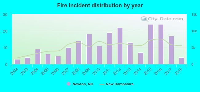 According to the data from the years 2002 - 2018 the average number of fire incidents per year is 12. The highest number of reported fires - 24 took place in 2015, and the least - 3 in 2002. The data has a growing trend.
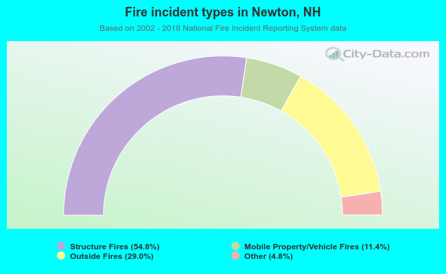 When looking into fire subcategories, the most reports belonged to: Structure Fires (54.8%), and Outside Fires (29.0%).
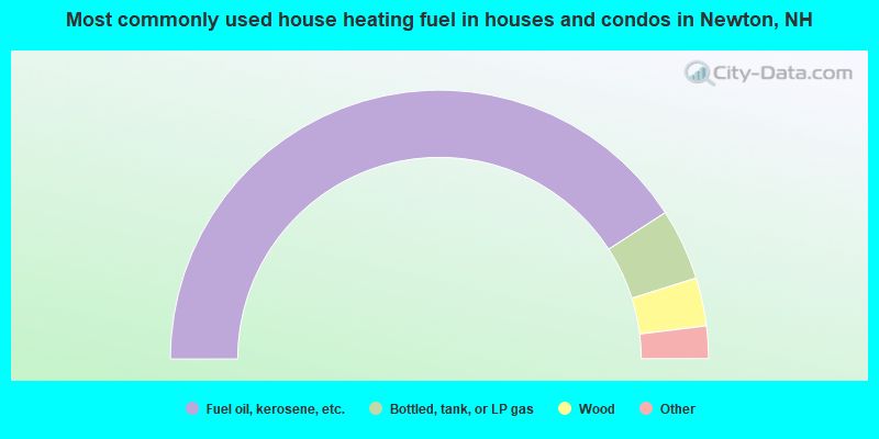
- 81.7%Fuel oil, kerosene, etc.
- 8.6%Bottled, tank, or LP gas
- 5.8%Wood
- 3.6%Electricity
- 0.3%Utility gas
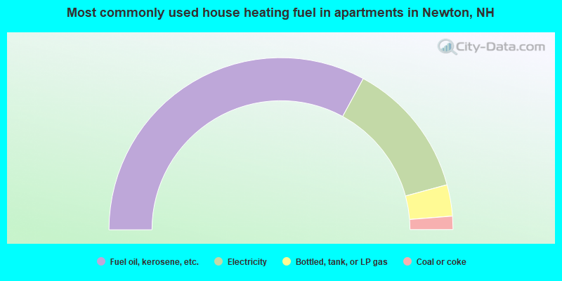
- 65.8%Fuel oil, kerosene, etc.
- 25.7%Electricity
- 5.9%Bottled, tank, or LP gas
- 2.5%Coal or coke
Newton compared to New Hampshire state average:
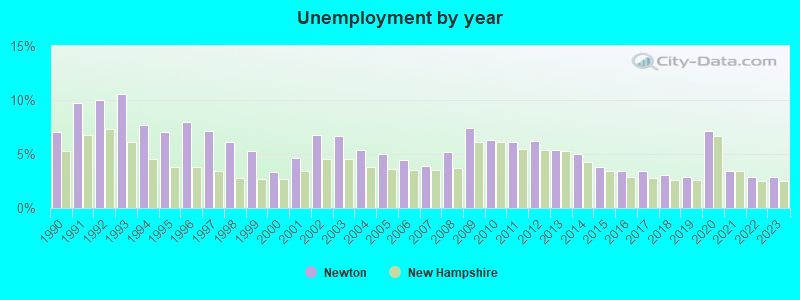
- Unemployed percentage significantly below state average.
- Black race population percentage significantly below state average.
- Hispanic race population percentage significantly below state average.
- Foreign-born population percentage significantly below state average.
- Renting percentage below state average.
- Length of stay since moving in significantly above state average.
- Number of rooms per house significantly below state average.
- House age significantly below state average.
State forum archive:

|
|
Total of 57 patent applications in 2008-2024.