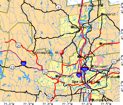
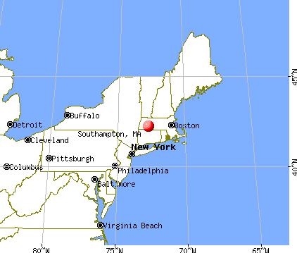
Southampton, Massachusetts
Submit your own pictures of this town and show them to the world
- OSM Map
- General Map
- Google Map
- MSN Map
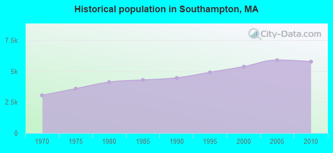
Population change since 2000: +7.5%
 |
| Males: 2,808 | |
| Females: 2,984 |
| Median resident age: | 44.7 years |
| Massachusetts median age: | 39.2 years |
Zip codes: 01073.
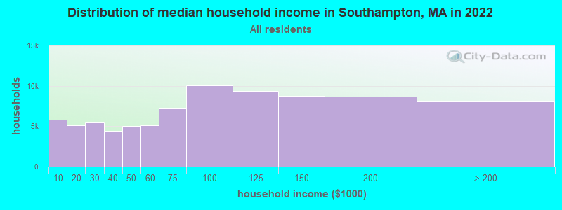
| Southampton: | $110,091 |
| MA: | $94,488 |
Estimated per capita income in 2022: $50,265 (it was $26,205 in 2000)
Southampton town income, earnings, and wages data
Estimated median house or condo value in 2022: $410,623 (it was $158,000 in 2000)
| Southampton: | $410,623 |
| MA: | $534,700 |
Mean prices in 2022: all housing units: $406,762; detached houses: $418,541; townhouses or other attached units: $363,334; in 2-unit structures: $269,911; in 3-to-4-unit structures: $561,325; in 5-or-more-unit structures: $236,751; mobile homes: $362,036
Detailed information about poverty and poor residents in Southampton, MA


- 5,59396.6%White alone
- 851.5%Hispanic
- 540.9%Two or more races
- 320.6%Asian alone
- 200.3%Black alone
- 50.09%American Indian alone
- 30.05%Other race alone
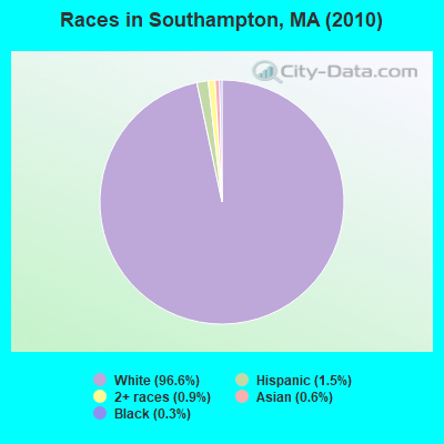
Races in Southampton detailed stats: ancestries, foreign born residents, place of birth
According to our research of Massachusetts and other state lists, there were 3 registered sex offenders living in Southampton, Massachusetts as of April 24, 2024.
The ratio of all residents to sex offenders in Southampton is 1,931 to 1.
The ratio of registered sex offenders to all residents in this city is lower than the state average.
Type |
2009 |
2010 |
2011 |
2012 |
2013 |
2014 |
2015 |
2016 |
2017 |
2018 |
2019 |
2020 |
2021 |
2022 |
|---|---|---|---|---|---|---|---|---|---|---|---|---|---|---|
| Murders (per 100,000) | 0 (0.0) | 0 (0.0) | 0 (0.0) | 0 (0.0) | 0 (0.0) | 0 (0.0) | 0 (0.0) | 0 (0.0) | 0 (0.0) | 0 (0.0) | 0 (0.0) | 0 (0.0) | 0 (0.0) | 0 (0.0) |
| Rapes (per 100,000) | 0 (0.0) | 3 (51.8) | 0 (0.0) | 1 (17.1) | 2 (33.5) | 1 (16.6) | 0 (0.0) | 0 (0.0) | 3 (47.9) | 0 (0.0) | 1 (16.0) | 0 (0.0) | 1 (16.1) | 1 (16.2) |
| Robberies (per 100,000) | 1 (16.2) | 0 (0.0) | 0 (0.0) | 0 (0.0) | 1 (16.7) | 0 (0.0) | 1 (16.3) | 2 (32.1) | 0 (0.0) | 0 (0.0) | 0 (0.0) | 1 (16.1) | 0 (0.0) | 0 (0.0) |
| Assaults (per 100,000) | 15 (243.5) | 4 (69.1) | 11 (188.8) | 2 (34.3) | 1 (16.7) | 3 (49.8) | 10 (162.6) | 6 (96.4) | 8 (127.7) | 11 (175.9) | 8 (128.1) | 5 (80.5) | 2 (32.3) | 9 (145.7) |
| Burglaries (per 100,000) | 11 (178.6) | 17 (293.5) | 17 (291.7) | 16 (274.3) | 9 (150.6) | 5 (82.9) | 14 (227.7) | 11 (176.7) | 13 (207.6) | 4 (64.0) | 12 (192.1) | 5 (80.5) | 3 (48.4) | 4 (64.8) |
| Thefts (per 100,000) | 39 (633.1) | 39 (673.3) | 32 (549.2) | 49 (840.2) | 36 (602.4) | 25 (414.6) | 29 (471.6) | 21 (337.4) | 25 (399.2) | 23 (367.8) | 22 (352.2) | 77 (1,239) | 24 (387.2) | 25 (404.7) |
| Auto thefts (per 100,000) | 2 (32.5) | 1 (17.3) | 2 (34.3) | 2 (34.3) | 1 (16.7) | 0 (0.0) | 4 (65.1) | 1 (16.1) | 3 (47.9) | 2 (32.0) | 2 (32.0) | 2 (32.2) | 0 (0.0) | 0 (0.0) |
| Arson (per 100,000) | 0 (0.0) | 3 (51.8) | 1 (17.2) | 0 (0.0) | 0 (0.0) | 0 (0.0) | 1 (16.3) | 0 (0.0) | 1 (16.0) | 0 (0.0) | 0 (0.0) | 0 (0.0) | 0 (0.0) | 1 (16.2) |
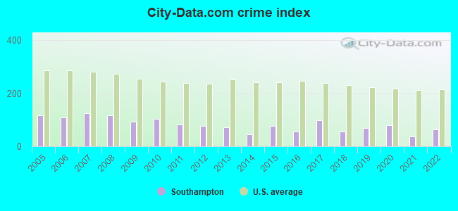
| City-Data.com crime index | 94.0 | 104.1 | 82.9 | 76.1 | 71.1 | 45.6 | 77.4 | 56.1 | 98.2 | 56.9 | 68.5 | 78.7 | 38.2 | 62.8 |
The City-Data.com crime index weighs serious crimes and violent crimes more heavily. Higher means more crime, U.S. average is 246.1. It adjusts for the number of visitors and daily workers commuting into cities.
Crime rate in Southampton detailed stats: murders, rapes, robberies, assaults, burglaries, thefts, arson
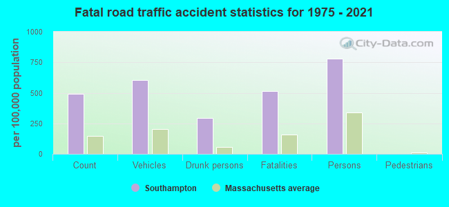
Full-time law enforcement employees in 2021, including police officers: 13 (9 officers - 9 male; 0 female).
| Officers per 1,000 residents here: | 1.45 |
| Massachusetts average: | 2.53 |
 Recent articles from our blog. Our writers, many of them Ph.D. graduates or candidates, create easy-to-read articles on a wide variety of topics.

 | Big MA Ancestry Data Thread by Town (31 replies) |
| 1 day trip across MA - what route for iconic scenery? (43 replies) |
| The Methadone Mile (465 replies) |
| Police expecting a rough summer ahead, in the city. (2472 replies) |
| Is it possible to escape hunters, ATVs and noise in a rural area? (278 replies) |
| Coronavirus in Massachusetts (18047 replies) |
Latest news from Southampton, MA collected exclusively by city-data.com from local newspapers, TV, and radio stations
Ancestries: Polish (24.8%), Irish (21.1%), French (18.3%), English (13.8%), French Canadian (10.8%), German (10.8%).
Current Local Time: EST time zone
Incorporated in 1775
Elevation: 230 feet
Land area: 28.1 square miles.
Population density: 206 people per square mile (very low).
215 residents are foreign born (2.5% Europe, 1.1% Latin America, 0.4% North America).
| This town: | 4.0% |
| Massachusetts: | 12.2% |
| Southampton town: | 1.3% ($2,112) |
| Massachusetts: | 1.3% ($2,336) |
Nearest city with pop. 50,000+: Chicopee, MA  (8.0 miles , pop. 54,653).
Nearest city with pop. 200,000+: Boston, MA (84.1 miles , pop. 589,141).
Nearest city with pop. 1,000,000+: Bronx, NY (112.2 miles , pop. 1,332,650).
Nearest cities:
), ), ), Latitude: 42.22 N, Longitude: 72.73 W
Area code commonly used in this area: 413

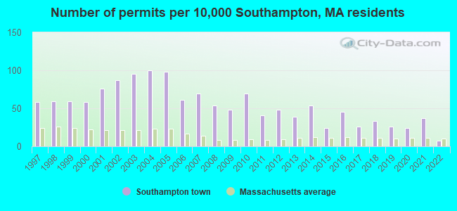
Single-family new house construction building permits:
- 2022: 4 buildings, average cost: $500,000
- 2021: 20 buildings, average cost: $600,000
- 2020: 13 buildings, average cost: $377,600
- 2019: 14 buildings, average cost: $411,300
- 2018: 18 buildings, average cost: $297,700
- 2017: 14 buildings, average cost: $242,100
- 2016: 24 buildings, average cost: $287,100
- 2015: 13 buildings, average cost: $254,700
- 2014: 29 buildings, average cost: $259,200
- 2013: 21 buildings, average cost: $198,100
- 2012: 26 buildings, average cost: $205,700
- 2011: 22 buildings, average cost: $386,400
- 2010: 37 buildings, average cost: $210,800
- 2009: 26 buildings, average cost: $220,400
- 2008: 29 buildings, average cost: $243,100
- 2007: 37 buildings, average cost: $263,300
- 2006: 33 buildings, average cost: $205,800
- 2005: 53 buildings, average cost: $188,500
- 2004: 54 buildings, average cost: $188,500
- 2003: 51 buildings, average cost: $188,500
- 2002: 47 buildings, average cost: $188,500
- 2001: 41 buildings, average cost: $188,500
- 2000: 31 buildings, average cost: $101,700
- 1999: 32 buildings, average cost: $101,700
- 1998: 32 buildings, average cost: $101,700
- 1997: 31 buildings, average cost: $101,700

| Here: | 2.6% |
| Massachusetts: | 3.5% |
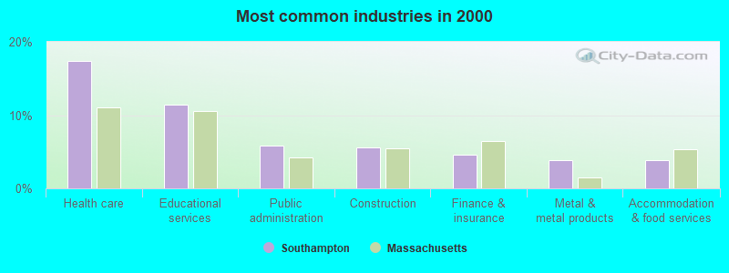
- Health care (17.4%)
- Educational services (11.4%)
- Public administration (5.8%)
- Construction (5.5%)
- Finance & insurance (4.5%)
- Metal & metal products (3.9%)
- Accommodation & food services (3.8%)
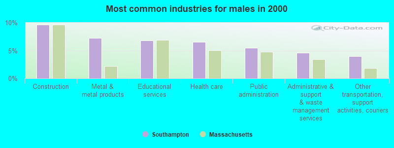
- Construction (9.7%)
- Metal & metal products (7.2%)
- Educational services (6.8%)
- Health care (6.6%)
- Public administration (5.5%)
- Administrative & support & waste management services (4.6%)
- Other transportation, support activities, couriers (3.9%)
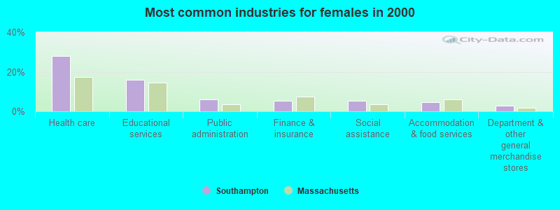
- Health care (28.0%)
- Educational services (15.9%)
- Public administration (6.1%)
- Finance & insurance (5.4%)
- Social assistance (5.3%)
- Accommodation & food services (4.6%)
- Department & other general merchandise stores (2.9%)
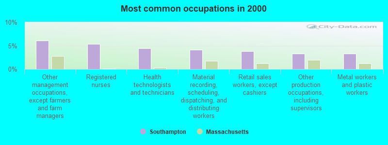
- Other management occupations, except farmers and farm managers (6.1%)
- Registered nurses (5.4%)
- Health technologists and technicians (4.5%)
- Material recording, scheduling, dispatching, and distributing workers (4.2%)
- Retail sales workers, except cashiers (3.8%)
- Other production occupations, including supervisors (3.3%)
- Metal workers and plastic workers (3.3%)
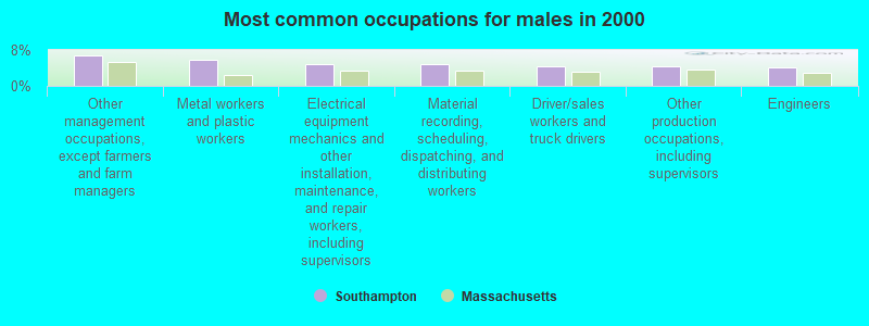
- Other management occupations, except farmers and farm managers (6.8%)
- Metal workers and plastic workers (5.9%)
- Electrical equipment mechanics and other installation, maintenance, and repair workers, including supervisors (4.9%)
- Material recording, scheduling, dispatching, and distributing workers (4.7%)
- Driver/sales workers and truck drivers (4.5%)
- Other production occupations, including supervisors (4.4%)
- Engineers (4.2%)
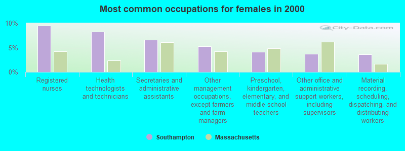
- Registered nurses (9.5%)
- Health technologists and technicians (8.2%)
- Secretaries and administrative assistants (6.6%)
- Other management occupations, except farmers and farm managers (5.3%)
- Preschool, kindergarten, elementary, and middle school teachers (4.1%)
- Other office and administrative support workers, including supervisors (3.7%)
- Material recording, scheduling, dispatching, and distributing workers (3.6%)
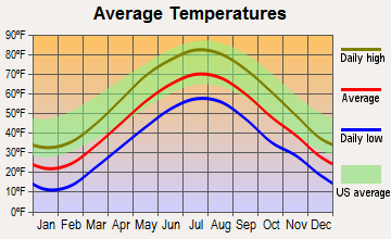
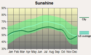
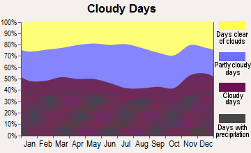
Average climate in Southampton, Massachusetts
Based on data reported by over 4,000 weather stations
(lower is better)
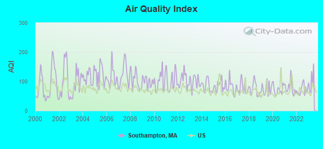
Air Quality Index (AQI) level in 2022 was 71.5. This is about average.
| City: | 71.5 |
| U.S.: | 72.6 |
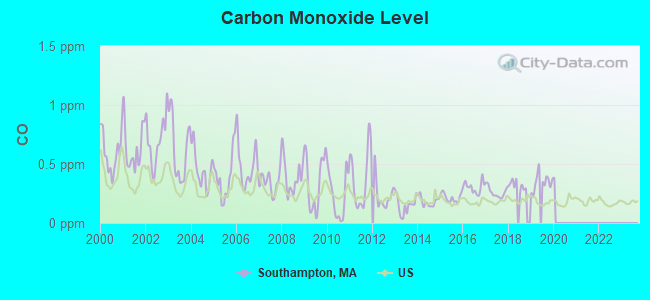
Carbon Monoxide (CO) [ppm] level in 2019 was 0.346. This is worse than average. Closest monitor was 6.8 miles away from the city center.
| City: | 0.346 |
| U.S.: | 0.251 |
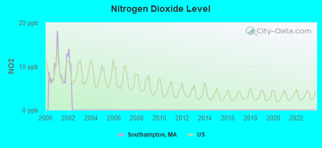
Nitrogen Dioxide (NO2) [ppb] level in 2001 was 9.75. This is significantly worse than average. Closest monitor was 6.8 miles away from the city center.
| City: | 9.75 |
| U.S.: | 5.11 |
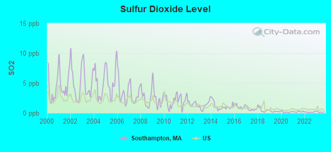
Sulfur Dioxide (SO2) [ppb] level in 2022 was 0.156. This is significantly better than average. Closest monitor was 5.3 miles away from the city center.
| City: | 0.156 |
| U.S.: | 1.515 |
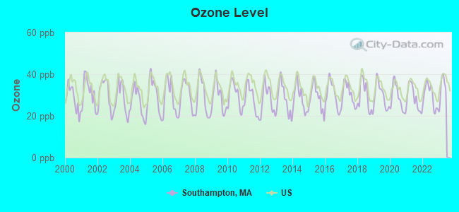
Ozone [ppb] level in 2022 was 29.4. This is about average. Closest monitor was 7.3 miles away from the city center.
| City: | 29.4 |
| U.S.: | 33.3 |
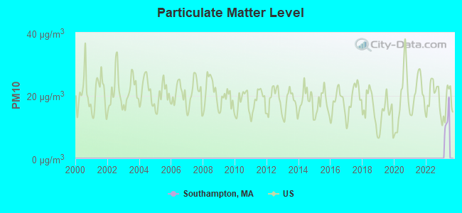
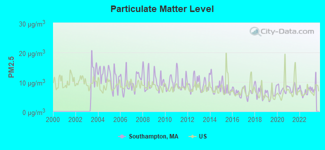
Particulate Matter (PM2.5) [µg/m3] level in 2022 was 6.79. This is about average. Closest monitor was 9.1 miles away from the city center.
| City: | 6.79 |
| U.S.: | 8.11 |
Tornado activity:
Southampton-area historical tornado activity is above Massachusetts state average. It is 8% smaller than the overall U.S. average.
On 10/3/1979, a category F4 (max. wind speeds 207-260 mph) tornado 12.1 miles away from the Southampton town center killed 3 people and injured 500 people and caused between $50,000,000 and $500,000,000 in damages.
On 5/29/1995, a category F4 tornado 23.0 miles away from the town center killed 3 people and injured 24 people and caused between $5,000,000 and $50,000,000 in damages.
Earthquake activity:
Southampton-area historical earthquake activity is significantly above Massachusetts state average. It is 70% smaller than the overall U.S. average.On 10/7/1983 at 10:18:46, a magnitude 5.3 (5.1 MB, 5.3 LG, 5.1 ML, Class: Moderate, Intensity: VI - VII) earthquake occurred 144.7 miles away from the city center
On 4/20/2002 at 10:50:47, a magnitude 5.3 (5.3 ML, Depth: 3.0 mi) earthquake occurred 165.6 miles away from the city center
On 4/20/2002 at 10:50:47, a magnitude 5.2 (5.2 MB, 4.2 MS, 5.2 MW, 5.0 MW) earthquake occurred 164.3 miles away from the city center
On 1/19/1982 at 00:14:42, a magnitude 4.7 (4.5 MB, 4.7 MD, 4.5 LG, Class: Light, Intensity: IV - V) earthquake occurred 105.2 miles away from Southampton center
On 10/16/2012 at 23:12:25, a magnitude 4.7 (4.7 ML, Depth: 10.0 mi) earthquake occurred 141.6 miles away from the city center
On 8/23/2011 at 17:51:04, a magnitude 5.8 (5.8 MW, Depth: 3.7 mi) earthquake occurred 406.1 miles away from the city center
Magnitude types: regional Lg-wave magnitude (LG), body-wave magnitude (MB), duration magnitude (MD), local magnitude (ML), surface-wave magnitude (MS), moment magnitude (MW)
Natural disasters:
The number of natural disasters in Hampshire County (21) is greater than the US average (15).Major Disasters (Presidential) Declared: 10
Emergencies Declared: 10
Causes of natural disasters: Floods: 5, Snowstorms: 5, Storms: 5, Hurricanes: 4, Winter Storms: 4, Blizzards: 2, Snows: 2, Snowfall: 1, Tropical Storm: 1, Wind: 1, Other: 1 (Note: some incidents may be assigned to more than one category).
Hospitals and medical centers near Southampton:
- LOOMIS HOUSE NURSING CENTER (Nursing Home, about 5 miles away; HOLYOKE, MA)
- HOLYOKE REHABILITATION CENTER (Nursing Home, about 5 miles away; HOLYOKE, MA)
- HOLYOKE NURSING HOME, INC (Nursing Home, about 6 miles away; HOLYOKE, MA)
- HOLYOKE MEDICAL CENTER Acute Care Hospitals (about 6 miles away; HOLYOKE, MA)
- OAK MANOR NURSING HOME (Nursing Home, about 6 miles away; HOLYOKE, MA)
- HOLYOKE HEALTH CARE CENTER (Nursing Home, about 6 miles away; HOLYOKE, MA)
- RENAISSANCE MANOR ON CABOT (Nursing Home, about 6 miles away; HOLYOKE, MA)
Amtrak stations near Southampton:
- 11 miles: SPRINGFIELD (66 LYMAN ST.) . Services: ticket office, partially wheelchair accessible, enclosed waiting area, public restrooms, public payphones, full-service food facilities, snack bar, vending machines, ATM, paid short-term parking, paid long-term parking, call for car rental service, taxi stand, intercity bus service, public transit connection.
- 16 miles: AMHERST (RAILROAD ST.) . Services: enclosed waiting area, public payphones, free short-term parking, paid long-term parking, call for car rental service, call for taxi service, public transit connection.
Colleges/universities with over 2000 students nearest to Southampton:
- Holyoke Community College (about 5 miles; Holyoke, MA; Full-time enrollment: 4,911)
- Westfield State University (about 8 miles; Westfield, MA; FT enrollment: 5,548)
- Smith College (about 8 miles; Northampton, MA; FT enrollment: 3,549)
- Mount Holyoke College (about 9 miles; South Hadley, MA; FT enrollment: 2,573)
- Springfield Technical Community College (about 11 miles; Springfield, MA; FT enrollment: 4,750)
- American International College (about 12 miles; Springfield, MA; FT enrollment: 2,733)
- Springfield College (about 13 miles; Springfield, MA; FT enrollment: 3,144)
Public high school in Southampton:
- HAMILTON-WENHAM REGIONAL HIGH (Students: 716, Location: 775 BAY RD, Grades: 9-12)
Private high school in Southampton:
Public elementary/middle schools in Southampton:
- WINTHROP SCHOOL (Students: 365, Location: 325 BAY RD, Grades: PK-5)
- CUTLER SCHOOL (Students: 324, Location: 237 ASBURY STREET, Grades: KG-5)
Points of interest:
Notable locations in Southampton: Bashista Orchards (A), Southampton Country Club (B), Southampton Town Hall (C), Southampton Fire Department Station 2 (D), Southampton Fire Department Station 1 Headquarters (E). Display/hide their locations on the map
Cemetery: Southampton Center Cemetery (1). Display/hide its location on the map
Reservoirs and swamps: Alder Pond (A), Lyman Pond (B), Lost Pond (C), New Intake Reservoir (D), Tighe Carmody Reservoir (E), White Reservoir (F), Pomeroys Meadow (G), Hackmatack Swamp (H). Display/hide their locations on the map
Streams, rivers, and creeks: Moose Brook (A), Tucker Brook (B), Sacket Brook (C), Breakneck Brook (D), Blue Meadow Brook (E), Tripple Brook (F), Potash Brook (G), North Branch Manhan River (H). Display/hide their locations on the map
Parks in Southampton include: Conant Memorial Park (1), Southampton Center Historic District (2), Pulaski Park (3). Display/hide their locations on the map
Birthplace of: Lewis Strong Clarke - Businessman, Samuel C. Pomeroy - Politician, Alvan Wentworth Chapman - Physician.
Drinking water stations with addresses in Southampton and their reported violations in the past:
SOUTHAMPTON WATER DEPT (Address: 8 FOMER ROAD , Population served: 3,967, Purch surface water):Past health violations:
- MCL, Monthly (TCR) - In JUL-2014, Contaminant: Coliform. Follow-up actions: St AO (w/o penalty) issued (2 times from AUG-15-2014 to AUG-19-2014)
- MCL, Monthly (TCR) - In SEP-2013, Contaminant: Coliform. Follow-up actions: St AO (w/o penalty) issued (MAR-20-2014)
- MCL, Monthly (TCR) - In APR-2013, Contaminant: Coliform. Follow-up actions: St AO (w/o penalty) issued (2 times from MAY-08-2013 to MAR-20-2014)
| This town: | 2.6 people |
| Massachusetts: | 2.5 people |
| This town: | 74.8% |
| Whole state: | 63.0% |
| This town: | 6.3% |
| Whole state: | 7.0% |
Likely homosexual households (counted as self-reported same-sex unmarried-partner households)
- Lesbian couples: 0.9% of all households
- Gay men: 0.0% of all households
| This town: | 2.4% |
| Whole state: | 9.3% |
| This town: | 0.4% |
| Whole state: | 4.4% |
Banks with branches in Southampton (2011 data):
- Easthampton Savings Bank: Southampton Branch at 134 College Highway, branch established on 1973/07/02. Info updated 2008/10/14: Bank assets: $939.2 mil, Deposits: $757.1 mil, headquarters in Easthampton, MA, positive income, Mortgage Lending Specialization, 9 total offices, Holding Company: Esb Bancorp Mhc
For population 15 years and over in Southampton:
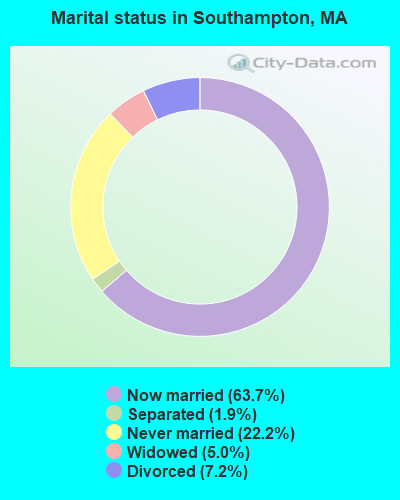
- Never married: 22.2%
- Now married: 63.7%
- Separated: 1.9%
- Widowed: 5.0%
- Divorced: 7.2%
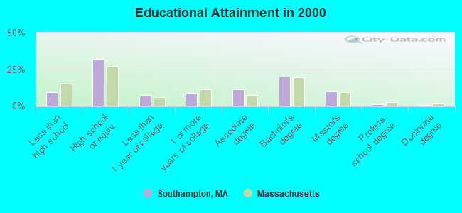
For population 25 years and over in Southampton:
- High school or higher: 90.9%
- Bachelor's degree or higher: 31.3%
- Graduate or professional degree: 11.4%
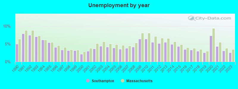
- Unemployed: 4.2%
- Mean travel time to work (commute): 24.8 minutes
| Here: | 10.1 |
| Massachusetts average: | 13.1 |
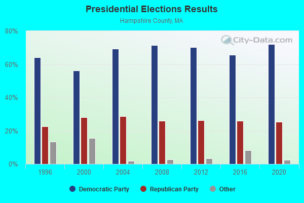
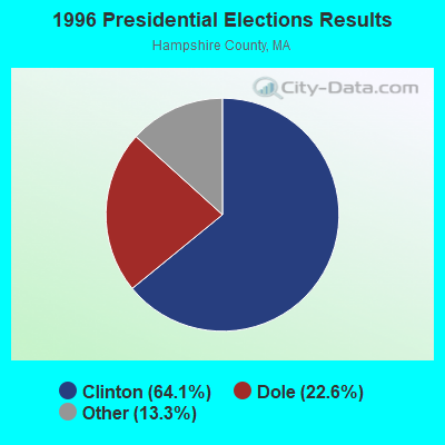
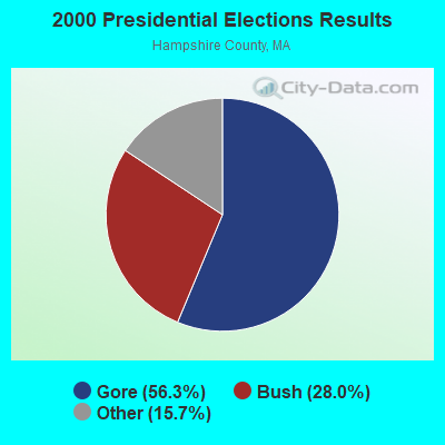
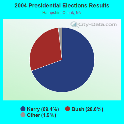
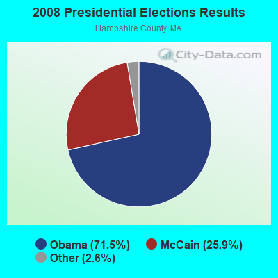
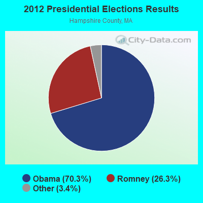
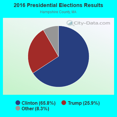
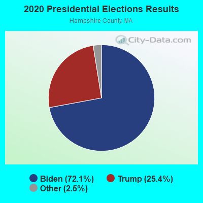
Graphs represent county-level data. Detailed 2008 Election Results
Religion statistics for Southampton, MA (based on Hampshire County data)
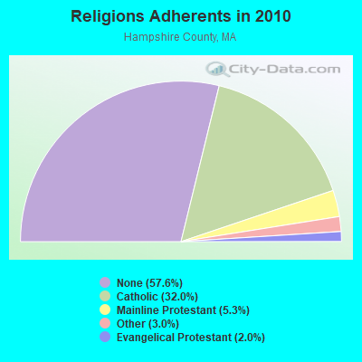
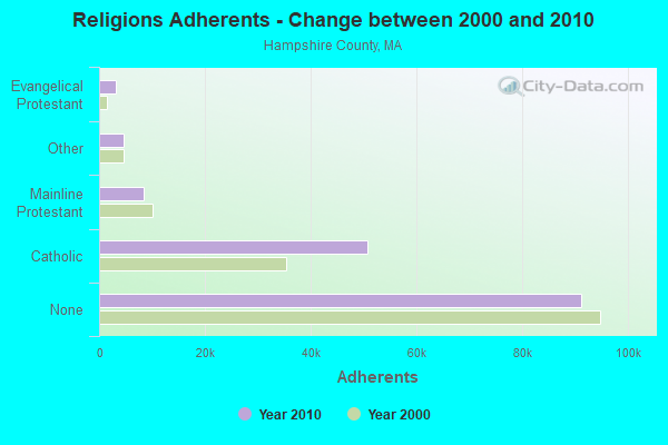
| Religion | Adherents | Congregations |
|---|---|---|
| Catholic | 50,643 | 22 |
| Mainline Protestant | 8,454 | 45 |
| Other | 4,722 | 27 |
| Evangelical Protestant | 3,128 | 22 |
| Black Protestant | 29 | 1 |
| None | 91,104 | - |
Food Environment Statistics:
| Hampshire County: | 2.07 / 10,000 pop. |
| Massachusetts: | 1.98 / 10,000 pop. |
| This county: | 0.06 / 10,000 pop. |
| Massachusetts: | 0.05 / 10,000 pop. |
| This county: | 1.55 / 10,000 pop. |
| Massachusetts: | 2.22 / 10,000 pop. |
| This county: | 1.94 / 10,000 pop. |
| Massachusetts: | 1.77 / 10,000 pop. |
| This county: | 10.22 / 10,000 pop. |
| Massachusetts: | 8.76 / 10,000 pop. |
| Here: | 7.3% |
| State: | 8.1% |
| This county: | 21.7% |
| Massachusetts: | 22.5% |
| This county: | 12.3% |
| Massachusetts: | 16.5% |
| Businesses in Southampton, MA | ||||
| Name | Count | Name | Count | |
|---|---|---|---|---|
| Dunkin Donuts | 1 | Penske | 1 | |
| FedEx | 1 | Rite Aid | 1 | |
| GNC | 1 | Subway | 1 | |
| H&R Block | 1 | |||
Strongest AM radio stations in Southampton:
- WNNZ (640 AM; 50 kW; WESTFIELD, MA; Owner: CLEAR CHANNEL BROADCASTING LICENSES, INC.)
- WHYN (560 AM; 5 kW; SPRINGFIELD, MA; Owner: CLEAR CHANNEL BROADCASTING LICENSES, INC.)
- WACE (730 AM; 5 kW; CHICOPEE, MA; Owner: CARTER BROADCASTING CORP.)
- WTIC (1080 AM; 50 kW; HARTFORD, CT; Owner: INFINITY RADIO OPERATIONS INC.)
- WSPR (1270 AM; 5 kW; SPRINGFIELD, MA; Owner: ANTONIO F. AND HELENA R. GOIS, TENANTS BY THE ENTIRETY)
- WCRN (830 AM; 50 kW; WORCESTER, MA; Owner: CARTER BROADCASTING CORPORATION)
- WVNE (760 AM; daytime; 25 kW; LEICESTER, MA; Owner: BLOUNT MASSCOM, INC.)
- WPNI (1430 AM; 5 kW; AMHERST, MA; Owner: WESTERN MASSACHUSETTS RADIO COMPANY)
- WALE (990 AM; 50 kW; GREENVILLE, RI; Owner: NORTH AMERICAN BROADCASTING CO., INC.)
- WHMP (1400 AM; 1 kW; NORTHAMPTON, MA; Owner: SAGA COMMUNICATIONS OF NEW ENGLAND, LLC)
- WRKO (680 AM; 50 kW; BOSTON, MA; Owner: ENTERCOM BOSTON LICENSE, LLC)
- WGY (810 AM; 50 kW; SCHENECTADY, NY; Owner: CLEAR CHANNEL BROADCASTING LICENSES, INC.)
- WEEI (850 AM; 50 kW; BOSTON, MA; Owner: ENTERCOM BOSTON LICENSE, LLC)
Strongest FM radio stations in Southampton:
- WHYN-FM (93.1 FM; SPRINGFIELD, MA; Owner: CLEAR CHANNEL BROADCASTING LICENSES, INC.)
- WRNX (100.9 FM; AMHERST, MA; Owner: WESTERN MASSACHUSETTS RADIO COMPANY)
- WAQY (102.1 FM; SPRINGFIELD, MA; Owner: SAGA COMMUNICATIONS OF NEW ENGLAND, LLC)
- WCCH (103.5 FM; HOLYOKE, MA; Owner: HOLYOKE COMMUNITY COLLEGE)
- WPKX (97.9 FM; ENFIELD, CT; Owner: CAPSTAR TX LIMITED PARTNERSHIP)
- WFCR (88.5 FM; AMHERST, MA; Owner: UNIVERSITY OF MASSACHUSETTS)
- WLZX (99.3 FM; NORTHAMPTON, MA; Owner: SAGA COMMUNICATIONS OF NEW ENGLAND, LLC)
- WAMC-FM (90.3 FM; ALBANY, NY; Owner: WAMC)
- WAMH (89.3 FM; AMHERST, MA; Owner: TRUSTEES OF AMHERST COLLEGE)
- W246AM (97.1 FM; AMHERST, MA; Owner: GREAT NORTHERN RADIO, LLC)
- WEIB (106.3 FM; NORTHAMPTON, MA; Owner: CUTTING EDGE BROADCASTING, INC.)
- WRCH (100.5 FM; NEW BRITAIN, CT; Owner: INFINITY RADIO OPERATIONS INC.)
- WMAS-FM (94.7 FM; SPRINGFIELD, MA; Owner: LAPPIN COMMUNICATIONS, INC.)
- WEQX (102.7 FM; MANCHESTER, VT; Owner: NORTHSHIRE COMMUNICATIONS, INC.)
- WJAN (95.1 FM; SUNDERLAND, VT; Owner: 6 JOHNSON ROAD LICENSES, INC.)
- WTIC-FM (96.5 FM; HARTFORD, CT; Owner: INFINITY RADIO OPERATIONS INC.)
- WWUH (91.3 FM; WEST HARTFORD, CT; Owner: UNIVERSITY OF HARTFORD)
- WCCC-FM (106.9 FM; HARTFORD, CT; Owner: MARLIN BROADCASTING, LLC)
- WHVP (91.1 FM; HUDSON, NY; Owner: SOUND OF LIFE, INC.)
- WVAY (100.7 FM; WILMINGTON, VT; Owner: GREAT NORTHERN RADIO, L.L.C.)
TV broadcast stations around Southampton:
- W67DF (Channel 67; SPRINGFIELD, MA; Owner: TRINITY BROADCASTING NETWORK)
- WGGB-TV (Channel 40; SPRINGFIELD, MA; Owner: WGGB LICENSEE, LLC)
- WGBY-TV (Channel 57; SPRINGFIELD, MA; Owner: WGBH EDUCATIONAL FOUNDATION)
- WWLP (Channel 22; SPRINGFIELD, MA; Owner: WWLP BROADCASTING, LLC)
- WYDN (Channel 48; WORCESTER, MA; Owner: EDUCATIONAL PUBLIC TV CORPORATION)
- WTIC-TV (Channel 61; HARTFORD, CT; Owner: TRIBUNE TELEVISION COMPANY)
- W11BJ (Channel 11; HARTFORD, CT; Owner: COMMUNICATIONS SITE MANAGEMENT LLC)
- WUVN (Channel 18; HARTFORD, CT; Owner: ENTRAVISION HOLDINGS, LLC)
- WTXX (Channel 20; WATERBURY, CT; Owner: WTXX INC.)
- WVIT (Channel 30; NEW BRITAIN, CT; Owner: OUTLET BROADCASTING, INC)
- WDMR-LP (Channel 65; SPRINGFIELD, MA; Owner: ZGS HARTFORD, INC.)
- WEDH (Channel 24; HARTFORD, CT; Owner: CONNECTICUT PUBLIC BROADCASTING, INC.)
- WFSB (Channel 3; HARTFORD, CT; Owner: MEREDITH CORPORATION)
- W12CL (Channel 12; GRANBY, CT; Owner: SALVATORE MINNITI)
- National Bridge Inventory (NBI) Statistics
- 12Number of bridges
- 59ft / 18.2mTotal length
- $16,608,000Total costs
- 40,405Total average daily traffic
- 2,541Total average daily truck traffic
- 44,661Total future (year 21) average daily traffic
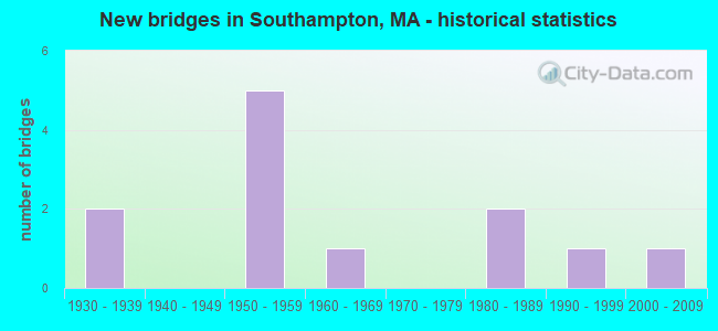
- New bridges - historical statistics
- 21930-1939
- 51950-1959
- 11960-1969
- 21980-1989
- 11990-1999
- 12000-2009
FCC Registered Antenna Towers:
17 (See the full list of FCC Registered Antenna Towers in Southampton)FCC Registered Broadcast Land Mobile Towers:
2- Hwy Garage Fomer Rd (Lat: 42.211472 Lon: -72.725361), Call Sign: KXQ795,
Assigned Frequencies: 159.060 MHz, Grant Date: 01/26/2015, Expiration Date: 12/12/2024, Registrant: Town Of Southampton, Massachusetts, 8 Fomer Road, Southampton, MA 01073, Phone: (413) 527-3666, Fax: (413) 529-0929, Email:
- WATER TANK, Water Storage Tank Off Wolcott Road (Lat: 42.243611 Lon: -72.734444), Type: Tank, Structure height: 9 m, Overall height: 12 m, Call Sign: WREQ482,
Assigned Frequencies: 217.400 MHz, Grant Date: 11/28/2019, Expiration Date: 11/28/2029, Certifier: Thomas Gaughan, Registrant: Tcs Communications Corp, Salisbury, MA 01952, Phone: (978) 465-7932, Fax: (978) 462-8980, Email:
FCC Registered Microwave Towers:
2- 5013, Southampton Country Club, College Hwy (Route 10) (Lat: 42.203333 Lon: -72.725083), Type: Pole, Structure height: 50.6 m, Call Sign: WPXE390,
Assigned Frequencies: 19325.0 MHz, Grant Date: 03/17/2003, Expiration Date: 03/17/2013, Cancellation Date: 12/27/2007, Certifier: Carol L Tacker, Registrant: Cingular Wireless LLC, 5601 Legacy Drive Ms A-3, Plano, TX 75024, Phone: (469) 229-7506, Fax: (469) 229-7295, Email:
- BS33XC003, Southampton Country Club, College Hwy (Route 10) (Lat: 42.203333 Lon: -72.725083), Type: Pole, Structure height: 50.6 m, Call Sign: WQPU702,
Assigned Frequencies: 11265.0 MHz, 11265.0 MHz, 11265.0 MHz, Grant Date: 08/20/2012, Expiration Date: 08/20/2022, Cancellation Date: 08/10/2022, Certifier: David Werblow, Registrant: Dla Piper LLP, 500 8th Street, Nw, Washington, DC 20004, Phone: (202) 799-4216, Fax: (202) 799-5616, Email:
FCC Registered Amateur Radio Licenses:
35 (See the full list of FCC Registered Amateur Radio Licenses in Southampton)FAA Registered Aircraft:
4- Aircraft: BELLANCA 7GCBC (Category: Land, Seats: 2, Weight: Up to 12,499 Pounds, Speed: 90 mph), Engine: LYCOMING 0-320 SERIES (180 HP) (Reciprocating)
N-Number: 289SR, N289SR, N-289SR, Serial Number: 435-73, Year manufactured: 1973, Airworthiness Date: 06/24/1997, Certificate Issue Date: 10/24/2020
Registrant (LLC): 30mm LLC, 39 Montgomery Rd, Southampton, MA 01073 - Aircraft: WACO UPF-7 (Category: Land, Seats: 2, Weight: Up to 12,499 Pounds, Speed: 165 mph), Engine: CONT MOTOR W670 SERIES (250 HP) (Reciprocating)
N-Number: 30165, N30165, N-30165, Serial Number: 5562, Year manufactured: 1941, Airworthiness Date: 05/02/1971, Certificate Issue Date: 10/22/2020
Registrant (Individual): Lise Marie Trustee Lemeland, 201 Pomeroy Meadow Rd, Southampton, MA 01073 - Aircraft: TEXTRON AVIATION INC G58 (Category: Land, Engines: 2, Seats: 6, Weight: Up to 12,499 Pounds), Engine: CONT MOTOR IO-550-C (300 HP) (Reciprocating)
N-Number: 877JL, N877JL, N-877JL, Serial Number: TH-2509, Year manufactured: 2018, Airworthiness Date: 09/28/2018, Certificate Issue Date: 10/01/2018
Registrant (LLC): 8-Ball Aviation LLC, 107 Valley Rd, Southampton, MA 01073 - Aircraft: BEECH F33A (Category: Land, Seats: 5, Weight: Up to 12,499 Pounds, Speed: 138 mph), Engine: CONT MOTOR IO 520 SERIES (285 HP) (Reciprocating)
N-Number: 977JL, N977JL, N-977JL, Serial Number: CE-872, Year manufactured: 1979, Airworthiness Date: 08/02/1979, Certificate Issue Date: 05/16/2018
Registrant (Co-Owned): James R Labrie, 66 Gunn Rd, Southampton, MA 01073, Other Owners: A Kathleen Labrie
2002 - 2018 National Fire Incident Reporting System (NFIRS) incidents
- Fire incident types reported to NFIRS in Southampton, MA
- 17437.6%Other
- 14330.9%Outside Fires
- 11825.5%Structure Fires
- 286.0%Mobile Property/Vehicle Fires
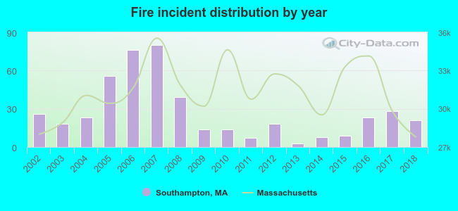 Based on the data from the years 2002 - 2018 the average number of fires per year is 27. The highest number of reported fires - 80 took place in 2007, and the least - 3 in 2013. The data has a dropping trend.
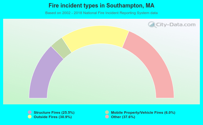 When looking into fire subcategories, the most incidents belonged to: Other (37.6%), and Outside Fires (30.9%).
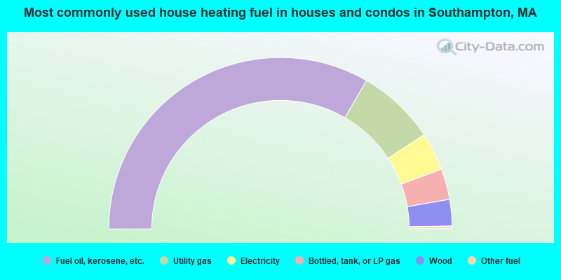
- 66.7%Fuel oil, kerosene, etc.
- 14.8%Utility gas
- 7.2%Electricity
- 5.8%Bottled, tank, or LP gas
- 5.0%Wood
- 0.5%Other fuel
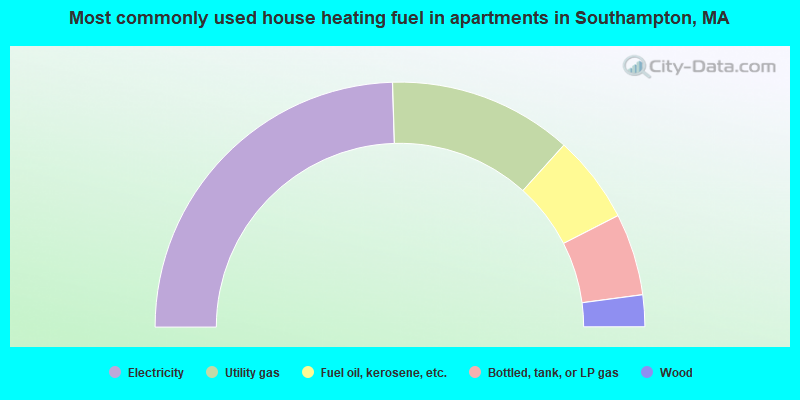
- 49.0%Electricity
- 24.3%Utility gas
- 11.6%Fuel oil, kerosene, etc.
- 10.8%Bottled, tank, or LP gas
- 4.2%Wood
Southampton compared to Massachusetts state average:
- Unemployed percentage significantly below state average.
- Black race population percentage significantly below state average.
- Hispanic race population percentage significantly below state average.
- Median age above state average.
- Foreign-born population percentage significantly below state average.
- Renting percentage significantly below state average.
- Length of stay since moving in significantly above state average.
- Number of rooms per house significantly below state average.
- House age significantly below state average.
Southampton on our top lists:
- #7 on the list of "Top 101 cities with largest percentage of females in industries: health care (population 5,000+)"
- #9 on the list of "Top 101 cities with largest percentage of females in occupations: registered nurses (population 5,000+)"
- #10 on the list of "Top 101 cities with largest percentage of females in industries: alcoholic beverages merchant wholesalers (population 5,000+)"
- #15 on the list of "Top 101 cities with largest percentage of males in occupations: nursing, psychiatric, and home health aides (population 5,000+)"
- #16 on the list of "Top 101 cities with largest percentage of females in occupations: therapists (population 5,000+)"
- #18 on the list of "Top 101 cities with largest percentage of males in industries: fuel dealers (population 5,000+)"
- #20 on the list of "Top 101 cities with largest percentage of females in industries: metals and minerals, except petroleum, merchant wholesalers (population 5,000+)"
- #23 on the list of "Top 101 cities with largest percentage of males in industries: vending machine operators (population 5,000+)"
- #29 on the list of "Top 101 cities with largest percentage of females in industries: petroleum and petroleum products merchant wholesalers (population 5,000+)"
- #30 on the list of "Top 101 cities with largest percentage of males in occupations: registered nurses (population 5,000+)"
- #34 on the list of "Top 101 cities with largest percentage of males in occupations: counselors, social workers, and other community and social service specialists (population 5,000+)"
- #35 on the list of "Top 101 cities with largest percentage of females in industries: repair and maintenance (population 5,000+)"
- #36 on the list of "Top 101 cities with largest percentage of males in industries: apparel, fabrics, and notions merchant wholesalers (population 5,000+)"
- #39 on the list of "Top 101 cities with largest percentage of females in industries: clothing and accessories, including shoe, stores (population 5,000+)"
- #42 on the list of "Top 101 cities with largest percentage of males in occupations: drafters, engineering, and mapping technicians (population 5,000+)"
- #43 on the list of "Top 101 cities with largest percentage of males in industries: book stores and news dealers (population 5,000+)"
- #44 on the list of "Top 101 cities with the lowest number of robberies per 100,000 residents (population 5,000+)"
- #51 on the list of "Top 101 cities with largest percentage of males in industries: miscellaneous manufacturing (population 5,000+)"
- #63 on the list of "Top 101 cities with largest percentage of females in industries: paper (population 5,000+)"
- #65 on the list of "Top 101 cities with largest percentage of females in industries: motor vehicle and parts dealers (population 5,000+)"
- #2 on the list of "Top 101 counties with the lowest number of births per 1000 residents 2007-2013"
- #9 on the list of "Top 101 counties with the lowest Particulate Matter (PM10) Annual air pollution readings in 2012 (µg/m3)"
- #19 on the list of "Top 101 counties with the lowest average weight of females"
- #30 on the list of "Top 101 counties with highest percentage of residents voting for 3rd party candidates in the 2012 Presidential Election (pop. 50,000+)"
- #41 on the list of "Top 101 counties with the highest percentage of residents that exercised in the past month"

|
|
Total of 19 patent applications in 2008-2024.