Please register to participate in our discussions with 2 million other members - it's free and quick! Some forums can only be seen by registered members. After you create your account, you'll be able to customize options and access all our 15,000 new posts/day with fewer ads.
Barelas has been a really fun neighborhood to live in since its revitalization. Lots of young people, artists and families are in the area now. With a builder finally chosen, the railyard project will hopefully make this part of town very desirable within the next 10 years. Properties are still very affordable, and I see a new home rehabilitation project underway virtually each month. Should be some great spots available in the near future.
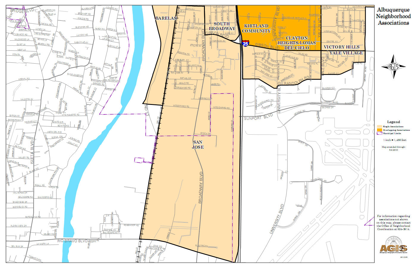
Barelas is basically just south of downtown, in the area around the zoo. I think the approximate boundaries are the railroad tracks to the east, Coal Ave. to the north, 10th St. to the west, and Bridge Blvd. to the south.
Barelas is basically just south of downtown, in the area around the zoo. I think the approximate boundaries are the railroad tracks to the east, Coal Ave. to the north, 10th St. to the west, and Bridge Blvd. to the south.
Close, but Coal Ave. to the North, Tingley Dr (The Rio Grande) West, and Woodward Road to the South ( further south of Bridge Blvd)
I am trying to once again learn the ALBUQUERQUE GIS DATA WEBSITE " + theTitle + "
Barelas is basically just south of downtown, in the area around the zoo. I think the approximate boundaries are the railroad tracks to the east, Coal Ave. to the north, 10th St. to the west, and Bridge Blvd. to the south.
Pretty much.
Quote:
Originally Posted by Northanna_2001
Where is Barelas; boundaried by what streets?
Brendan nailed it. It's the oldest neighborhood in ABQ. The "modern" history of the central Rio Grande region starts and moves outward from Barelas. The river landing just south of the neighborhood (where the NHCC is) is where Coronado crossed in 1540. It was a formal agricultural settlement as early as 1662 - 50 years before Old Town. Pretty cool.
Close, but Coal Ave. to the North, Tingley Dr (The Rio Grande) West, and Woodward Road to the South ( further south of Bridge Blvd)
I am trying to once again learn the ALBUQUERQUE GIS DATA WEBSITE " + theTitle + "
Rich
Barelas does not go all the way down to Woodward. That area used to be called South Barelas or West San Jose. (I grew up in San Jose and the San Jose area goes from Avenida Cesar Chavez down to Woodward, on the other side of the tracks from Barelas and west of I-25). However, nearly all the homes in that area were torn down in the 70s to build the industrial park where Bueno Foods is now located.
But even when it had residents those residents considered themselves as separate from Barelas. I know because my great-grandparents used to live in one of the houses that was torn down to make way for the industrial park. The one exception was Adela Martinez's property. Anyone who was here back then knows that the National Hispanic Cultural Center had to be designed around her house as she refused to sell her house to make way for it.
As cornflakes stated, BrendanM pretty much gave the correct boundaries of Barelas.
It does according to the City of Albuquerque. It does according to the mapping at the "Albuquerque GIS Data Website". Check it out here: " GIS Viewer " . It also shows all of the San Jose neigbhorhood to be East of the Railroad tracks.
Here is another map from the City of Albuquerque. You can see the San Jose area and the southern portion of Barrelas:
Just because people used to call an area South Barelas or West San Jose, does not mean that is the official name...
Rich
Last edited by Poncho_NM; 02-05-2012 at 10:32 PM..
It does according to the City of Akbuquerque. It does according to the mapping at the "Albuquerque GIS Data Website"
Just because people used to an area South Barelas or West San Jose, does not mean yhat is the official name...
Rich
And just because the City tries to neatly compartmentalize itself doesn't mean those boundaries are what is considered the actual neighborhood. You've brought that site up to me in another thread here recently. I've looked at it and it has some wacky boundaries.
Just taking the two neighborhoods where I've lived all my life, Barelas and San Jose, I can tell you that website and the city has it wrong. But I also know why they have it like they do. They do it for planning and ease of indentifying areas. That hardly makes it the final, definitive word on the matter of indentifying neighborhoods.
Taking San Jose, for example, that map has it going all the way down to Rio Bravo. Those of us who were born and raised there and know the area much better than some city planner know that it doesn't go all the way down to Rio Bravo. The area from Woodward to Rio Bravo is heavily commercial and industrial. Nobody lives there, so it's not really a neighborhood, but the city lumped it in with San Jose for planning purposes.
And San Jose is actually made up two distinct areas: East Side and South Side. South Side is a newer part of San Jose with some houses built with government funds as part of Urban Renewal in the sixties and seventies on former farm land. Why do you think there's an East San Jose Elementary School and not just a 'San Jose Elementary School'? And did you know that on the grounds of the National Hispanic Cultural Center is the remaining building of the old West San Jose Elementary School? It was preserved since it was built as a New Deal project in the '30s. It's now part of the Cultural Center's campus and is used by them. It also used to go by the name of Riverview Elementary School.
The same circumstances in San Jose apply on the other side of the tracks in Barelas. Barelas as a neighborhood lies north of Bridge Boulevard/Avenida Cesar Chavez. No one lives south of that street anymore as it is now an industrial park. But the City has lumped it in with Barelas for planning purposes.
But I'm telling you when it was populated no one that lived there considered it part of Barelas. It was its own neighborhood with its own school. My great-grandparents called it West San Jose (probably because we lived in East San Jose across the tracks), but to others it was South Barelas.
Going further into that site and how it has things wrong: They call only the area south of Coal between Broadway to the west and I-25 to the east north of Gibson "South Broadway". Nevermind that those of us who have lived or actually do live along Broadway south of Downtown call the entire area South Broadway. Within South Broadway are the neighborhoods of Guadalupe Park, San Jose (East and South Sides), and an area known to us locals as "the Sticks". "The Sticks" is the neighborhood south of Coal Avenue, east of Broadway and north of Avenida Cesar Chavez. Now, it is somewhat derogatory to call it "the Sticks" so the city has taken to labeling it as simply "South Broadway Neighborhood". But we who are from there will always call it the "the Sticks". As an aside, some parts south of Avenida Cesar Chavez can be considered the Sticks but not all the way down to Gibson. The area immediately northeast of Gibson and Broadway is definitely in the San Jose neighborhood.
Also, we who are from or live in those neighborhoods will always say we are from South Broadway. Don't ever call our area the South Valley! We are South Broadway, part of the City, not within the unincorporated areas of the South Valley. This is another mistake many non-locals and even city officials make when referring to this area of town.
If you don't want to believe the Cities Maps? Then don't...
Oh...
It's not a question of me believing anything. I know what I know. I've lived in those neighborhoods all my life and I know their histories. If you'd rather stick to some city planning documents go right ahead. But the rest of us who actually live in these places know our neighborhoods better than you or those city planners who created those supposed neighborhood boundaries. Some of which, btw, fall mostly outside city limits, such as in the case of the boundaries given for San Jose. So does the City not know its own limits or is it that they tried to make it easier for people to visualize different areas when it comes to city planning rather than stick to true, defined boundaries?
So does the City not know its own limits or is it that they tried to make it easier for people to visualize different areas when it comes to city planning rather than stick to true, defined boundaries?
Show me the "true, defined boundaries". Not postings from an unidentifiable internet user, but a verifiable "true, defined boundaries". Otherwise this is not something I wish to argue. I will go by maps published by the city....
Please register to post and access all features of our very popular forum. It is free and quick. Over $68,000 in prizes has already been given out to active posters on our forum. Additional giveaways are planned.
Detailed information about all U.S. cities, counties, and zip codes on our site: City-data.com.

 Please register to participate in our discussions with 2 million other members - it's free and quick! Some forums can only be seen by registered members. After you create your account, you'll be able to customize options and access all our 15,000 new posts/day with fewer ads.