Please register to participate in our discussions with 2 million other members - it's free and quick! Some forums can only be seen by registered members. After you create your account, you'll be able to customize options and access all our 15,000 new posts/day with fewer ads.
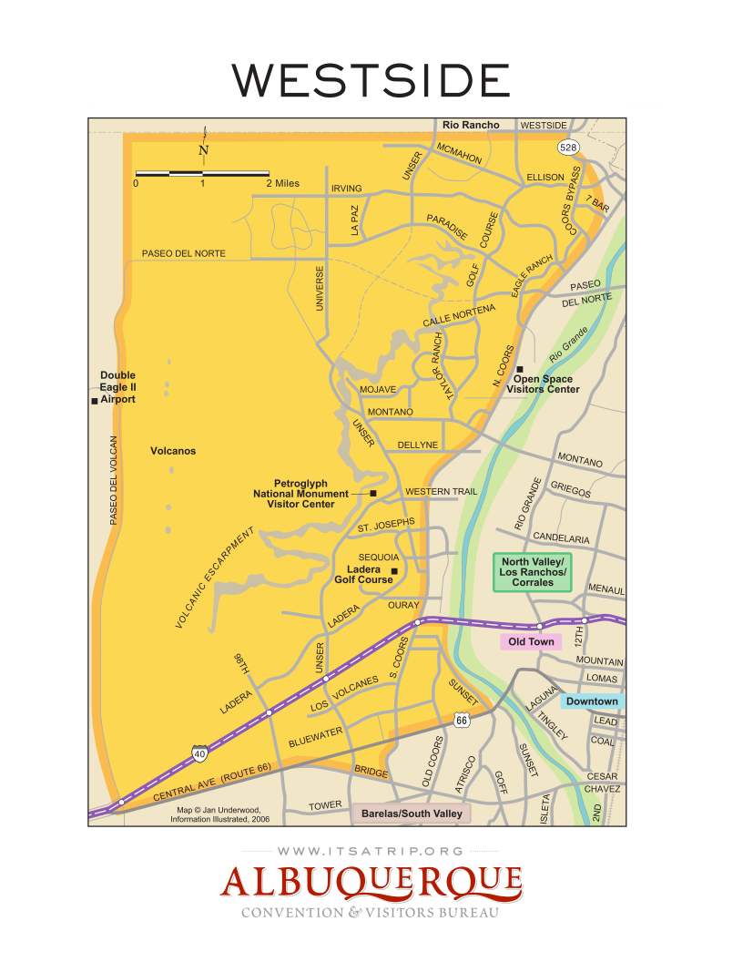
That map is just downright bizarre. Not only is the strip of land west of the Rio Grande and east of Coors, not the west side (I propose we now call those residents and businesses "fake" westsiders), but also just about anybody with a "SW" address as opposed to a "NW" one, not real west siders. Half of Cottonwood mall's big box zone looks to be non-westside as well.
Corrales is apparently now walking distance from Old Town.
And Barelas has apparently moved across the river instead of being ~1 cm south of Downtown. ::facepalm::
Our volcanoes are also missing their e, in classic Alburquerque fashion.
From what I can tell by looking at abq addressing scheme, and I may be wrong, but it seems like the city is bisected by the two freeways creating four quadrants and basically what it seems like to me and forgive me as I'm not a local but I've been researching housing there. It seems like when you look up an address it will typical have a NW or SW or SE or NE and when looking up on a map it seems to correlate to the quadrants I was talking about.
It would seem like the map would be NW???
Also, why isn't any area south of Central shown on the map??
Central Ave. and the railroad tracks mark the quadrants. I have no idea what this map is supposed to be showing. I guess addresses would be NW ?
Goofing around with google maps I can see how central somewhat parallels the 40, not seeing the railroad tracks, I'm assuming it parallels the 25 as well???
My first time posting, so please forgive me if I do something in error. I have lived in Albuquerque since 1988...and on the "westside" for approximately nine years. It is my understanding that addresses north of Central Avenue are considered "northwest", and below Central Avenue "southwest". The Rio Grande River is also a dividing marker, so land/properties east of the Rio Grande, and I believe north of Central and west of I-25 (or there about) are considered the "North Valley",however, not considered part of the "west-side". Confusing? Much less so than many other places. So, IMO, Albuquerque is comprised of four quadrants: Northeast, Northwest (properties north of Central with I-25 dividing "east" from "west"); and Southeast and Southwest (properties south of Central). I am unsure of what landmark or street separates "east" from "west" here. I believe it's a location in downtown Albuquerque.
My first time posting, so please forgive me if I do something in error. I have lived in Albuquerque since 1988...and on the "westside" for approximately nine years. It is my understanding that addresses north of Central Avenue are considered "northwest", and below Central Avenue "southwest". The Rio Grande River is also a dividing marker, so land/properties east of the Rio Grande, and I believe north of Central and west of I-25 (or there about) are considered the "North Valley",however, not considered part of the "west-side". Confusing? Much less so than many other places. So, IMO, Albuquerque is comprised of four quadrants: Northeast, Northwest (properties north of Central with I-25 dividing "east" from "west"); and Southeast and Southwest (properties south of Central). I am unsure of what landmark or street separates "east" from "west" here. I believe it's a location in downtown Albuquerque.
I don't think I'd consider Corrales or some of the properties immediately east of Coors but West of the river to be Westside either; those places are West of the river but have a different feel and character from say, Paradise Hills, Taylor Ranch, Ventana Ranch, or that part of ABQ that's immediately south of Rio Rancho.
Maybe symbolically you could say West of Coors but north Montano is Westside? I'd say Taylor Ranch has the feel of the places I've mentioned, but the Ladera area doesn't. Once you get further south than Taylor ranch, the feel of everything tends to quickly change. It starts to feel a lot less like typical "suburbia Americana" and a lot more culturally eclectic, but still not quite in the same way Corrales or Los Ranchos does because umm, let's face it, that area doesn't have nearly as much wealth.
I don't think it is that complicated. It is a map of a collection of neighborhoods collectively known as the Westside. It is not everything west of the river, nor a map of the NW quadrant.
As I understand it, Westside was coined to refer to the rapidly developed area west of Coors excluding the long settled valley areas adjacent to the river and long established SW locations like Atrisco, Five Points, and the South Valley.
Last edited by ABQConvict; 03-18-2017 at 09:52 AM..
Please register to post and access all features of our very popular forum. It is free and quick. Over $68,000 in prizes has already been given out to active posters on our forum. Additional giveaways are planned.
Detailed information about all U.S. cities, counties, and zip codes on our site: City-data.com.

 Please register to participate in our discussions with 2 million other members - it's free and quick! Some forums can only be seen by registered members. After you create your account, you'll be able to customize options and access all our 15,000 new posts/day with fewer ads.