U.S. Cities  

Go Back   City-Data Forum > U.S. Forums > New Mexico > Albuquerque
Register Blogs Search Today's Posts Mark Forums Read

Welcome to City-Data.com forum! Make sure to register - it's free and very quick! You have to register before you can post and participate in our discussions with 700,000 other registered members. User profiles and some forums can only be seen by registered members. After you create your free account you will be able to customize many options, you will have the full access to over 15,000 posts/day about local topics and you will see fewer ads.

Get a detailed profile
Search Forums  (Advanced)
Business Search - 14 Million verified businesses
Search for:  near: 
Reply


Old 06-05-2009, 10:58 PM
Moderator
Status: "It's chilly" (set 28 days ago)
 
Join Date: Dec 2008
Location: Rio Rancho, New Mexico USA
2,660 posts, read 1,008,036 times
Reputation: 1504
Poncho_NM has a brilliant futurePoncho_NM has a brilliant futurePoncho_NM has a brilliant futurePoncho_NM has a brilliant futurePoncho_NM has a brilliant futurePoncho_NM has a brilliant futurePoncho_NM has a brilliant futurePoncho_NM has a brilliant futurePoncho_NM has a brilliant futurePoncho_NM has a brilliant futurePoncho_NM has a brilliant futurePoncho_NM has a brilliant futurePoncho_NM has a brilliant futurePoncho_NM has a brilliant futurePoncho_NM has a brilliant futurePoncho_NM has a brilliant futurePoncho_NM has a brilliant futurePoncho_NM has a brilliant futurePoncho_NM has a brilliant futurePoncho_NM has a brilliant futurePoncho_NM has a brilliant futurePoncho_NM has a brilliant future
Default Cliffs at the end of Rainbow Blvd

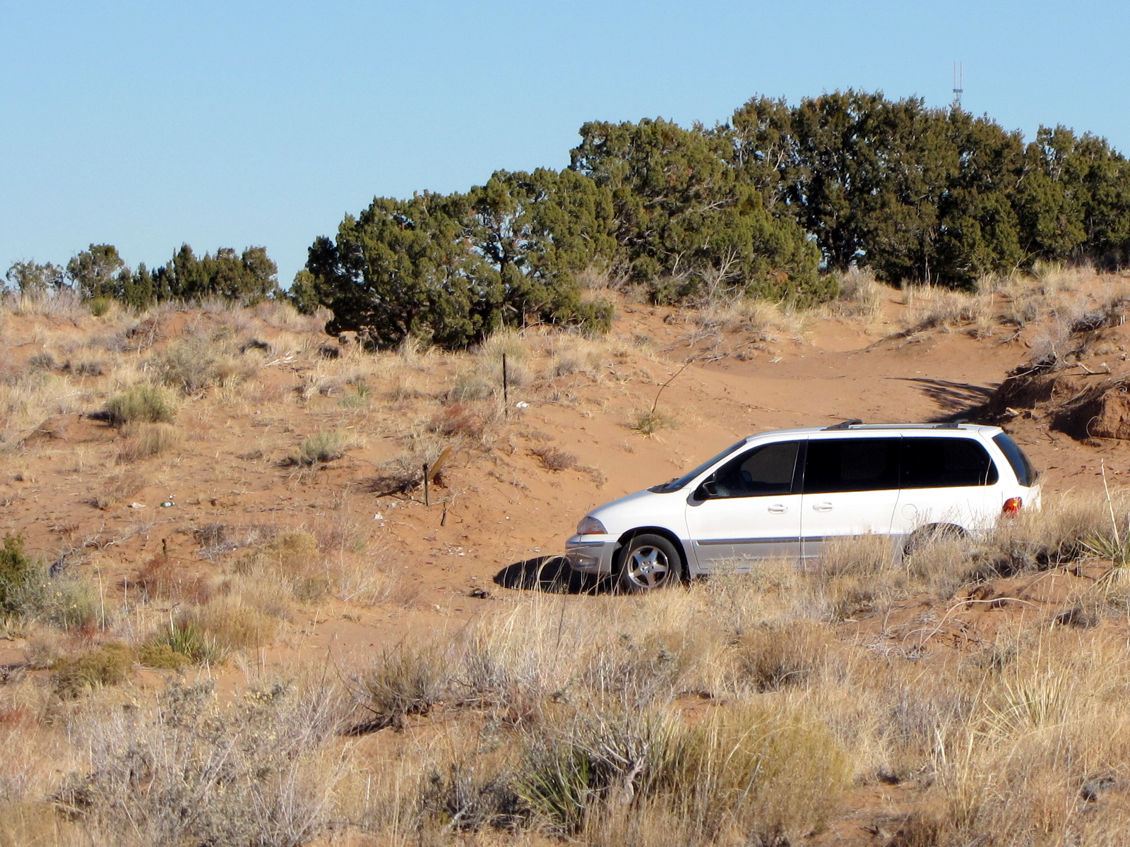
There are some cliffs at the north end of Rainbow Blvd in Rio Rancho. According to this Google Earth Map it is 9.85 miles from Northern Blvd. Or 12.10 miles if you start from Southern. You can't see much detail on the map, look at the end of the yellow line and look at the terrain closely. It is on the edge of a cliff.

Coordinates: 35°24'1.13"N 106°46'59.31"W


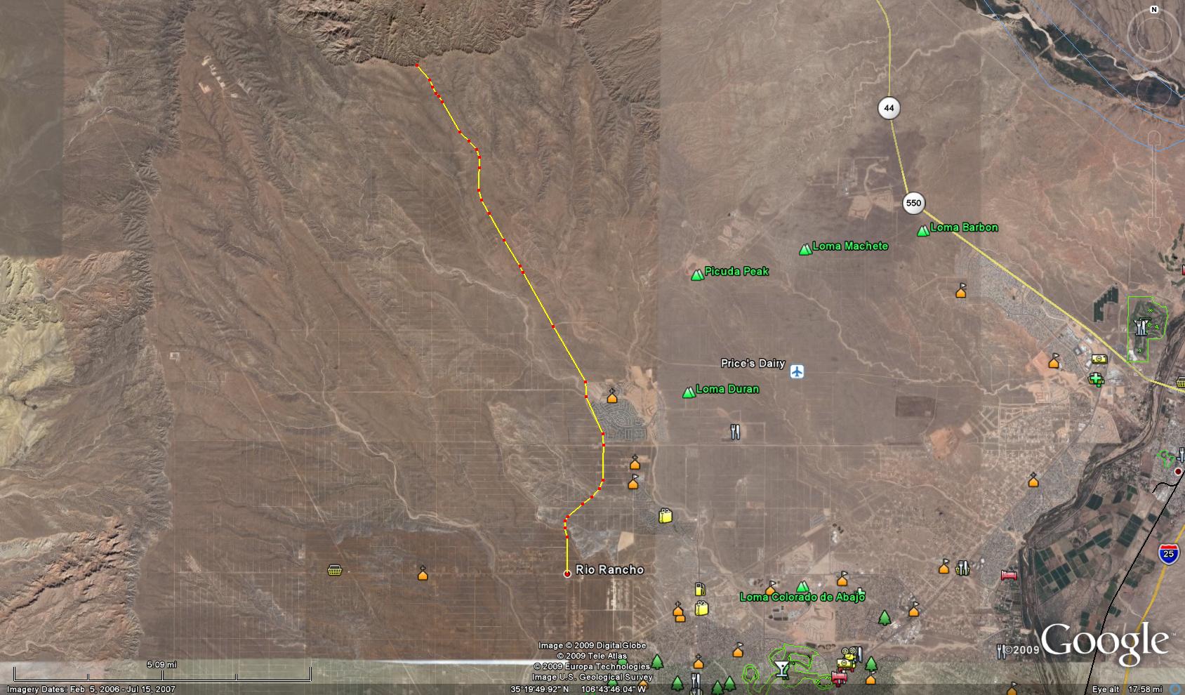
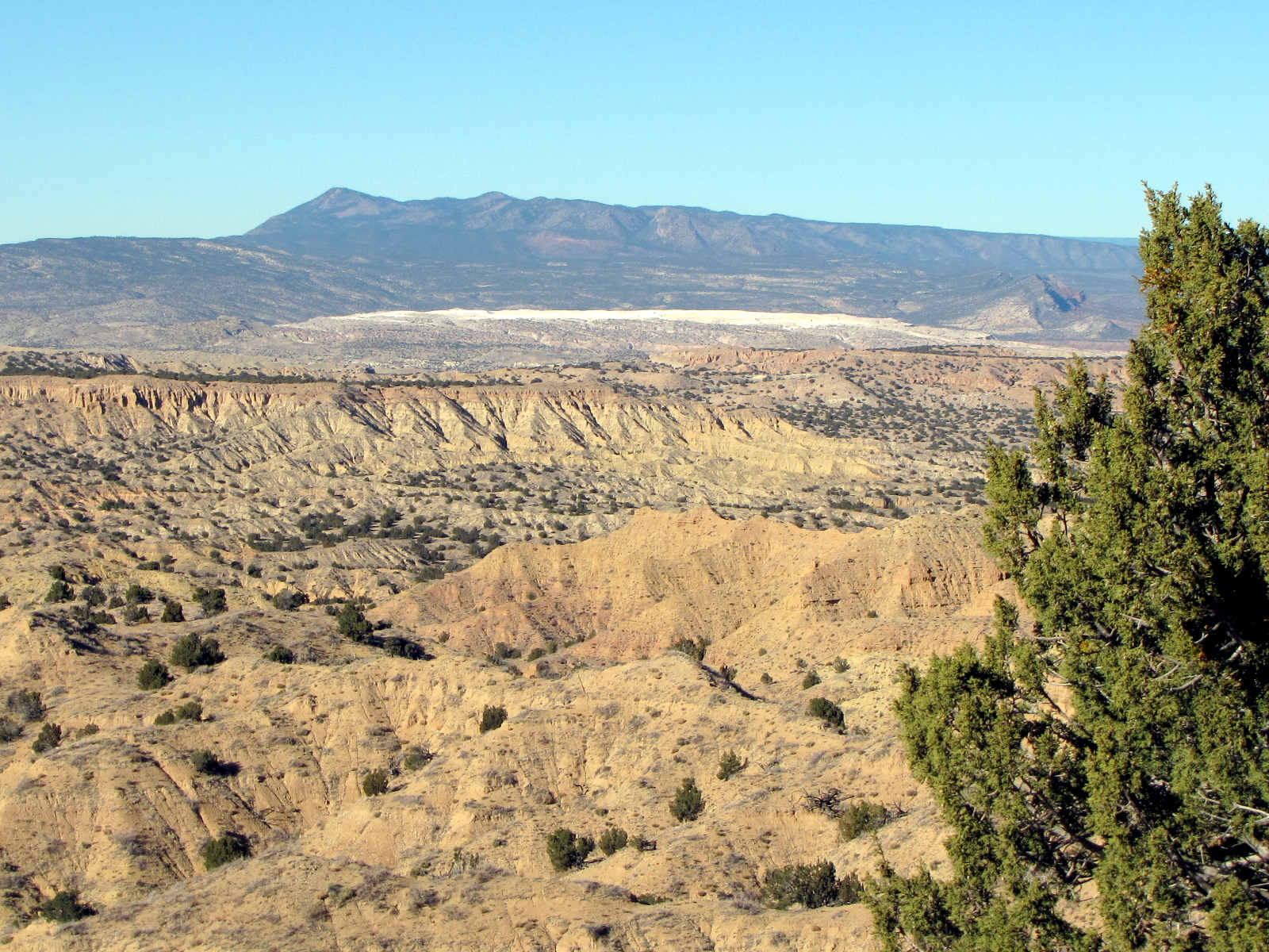
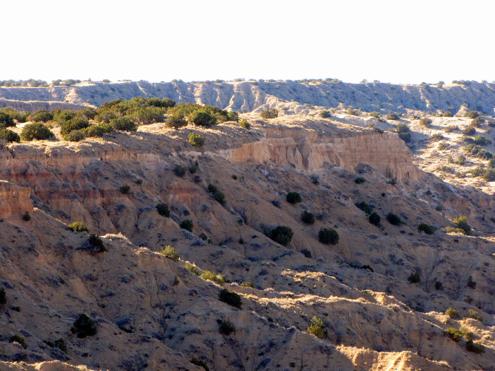
PHOTO BELOW -
You can see White Mesa, New Mexico in this photo which is about 9.5 miles away. You can access that area easily by driving out in a vehicle from Bernalillo on US 550. White Mesa gets its name from the gypsum that most of the mesa is composed of. The gypsum was the remains left over after the evaporation of an ocean that once covered this area. On the western edge of the mesa are high, narrow mesa ridges, part of the plunging Tierra Amarilla Anticline. Geologically speaking, this is a very interesting area. Also exposed here is the Morrison Formation, a layer of rock laid down about 150 million years ago. The Morrison is filled with dinosaur fossils and even large pieces of petrified wood, indicating that at one time, this area was covered with a forest frequented by dinosaurs. The fossilized skeleton of a Seismosaurus (the longest dinosaur skeleton ever recovered) was found just west of here in the Ojito Wilderness.

The village of San Ysidro is about 6 miles northeast of White Mesa.

There are mountain bicycle trails at White Mesa. The Bureau of Land Management White Mesa Bike Trails. About 20 miles northwest of Bernalillo on US 550, and about 2 miles south of San Ysidro, turn west on County Road 906 which is Cabezon Road Follow the left fork and go about 4.4 miles to the gravel parking area. Hikers are allowed to use the entire trail system and horseback riders are allowed to use one designated segment.


Rich

Last edited by Poncho_NM; 06-06-2009 at 08:31 AM..
Reply With Quote Quick reply to this message

 
Old 06-06-2009, 02:57 AM
Member
 
Join Date: Feb 2009
Location: Rio Rancho
23 posts, read 6,538 times
Reputation: 11
spottie is on a distinguished road
Oho, I didn't go far enough!
Reply With Quote Quick reply to this message
 
Old 06-06-2009, 04:27 PM
Senior Member
 
Join Date: Sep 2006
Location: Rio Rancho, NM
2,667 posts, read 1,720,115 times
Reputation: 1064
AlisonL has much to be proud ofAlisonL has much to be proud ofAlisonL has much to be proud ofAlisonL has much to be proud ofAlisonL has much to be proud ofAlisonL has much to be proud ofAlisonL has much to be proud ofAlisonL has much to be proud ofAlisonL has much to be proud ofAlisonL has much to be proud ofAlisonL has much to be proud ofAlisonL has much to be proud ofAlisonL has much to be proud ofAlisonL has much to be proud ofAlisonL has much to be proud ofAlisonL has much to be proud ofAlisonL has much to be proud of
Will have to take a ride out there one day soon. Rainbow is almost in my backyard.
Reply With Quote Quick reply to this message
Please register to post and access all features of our very popular forum. It is free and quick.

Detailed information about all U.S. cities, counties, and zip codes on our site: City-data.com.


Reply


Quick Reply
Message:

Thread Tools Search this Thread
Search this Thread:

Advanced Search
Display Modes

Similar Threads


Go Back   City-Data Forum > U.S. Forums > New Mexico > Albuquerque

All times are GMT -6. The time now is 02:16 AM.

Copyright © 2005-2010, Advameg, Inc.

City-Data.com - Archive 1, 2, 3, 4, 5, 6, 7, 8, 9, 10, 11, 12, 13 - Top