Please register to participate in our discussions with 2 million other members - it's free and quick! Some forums can only be seen by registered members. After you create your account, you'll be able to customize options and access all our 15,000 new posts/day with fewer ads.
The thing is, people who rely on GPS don't learn to understand the big picture of a place. They only think about getting from point a to point b, and have no clue what the rest of the area is like or what the other possibilities are.
If you don't learn the bigger picture, how can you ever find anything in the future?
Use of GPS makes you more reliant on GPS makes you more reliant on GPS.
If a satellite goes down, the streets will be filled with Millennials roaming around aimlessly bumping into one another and sobbing.
If a satellite goes down, the streets will be filled with Millennials roaming around aimlessly bumping into one another and sobbing.
Despite my name , I'll probably be collecting non-functional GPS devices to sell for rare earth metals.
Jokes aside, your "big picture" comment is spot-on. American cities were planned with ease of navigation in mind. And I mean actual cities, not exurban subdivisions with streets winding every which way. All cities older than 100 years,at least the ones on built on flat terrain, have some semblance of a grid. (A grid is harder to lay out when there are hills in the way, and streets need to curve around bodies of water.) Complete with zero points (where numbers start from) and a logical numbering system. Master that, and you can get around anywhere in your city, with just basic reading skills and knowing which compass direction (N, S, E, W) you're facing.
The thing is, people who rely on GPS don't learn to understand the big picture of a place. They only think about getting from point a to point b, and have no clue what the rest of the area is like or what the other possibilities are.
If you don't learn the bigger picture, how can you ever find anything in the future?
Use of GPS makes you more reliant on GPS makes you more reliant on GPS.
If a satellite goes down, the streets will be filled with Millennials roaming around aimlessly bumping into one another and sobbing.
if I'm only going there once, like when I was driving my wife as a notary around for house closings, why would I need to know "the bigger picture?"
And again, on my dash the nav is a nice map with roads, water, etc all laid out on it and I can use that to determine places I might want to go even when I'm not using turn by turn directions. I've gone on some nice scenic backroads and found some fun twisty ones by looking at that nav screen and seen some interesting roads coming up to turn on, and also determine before I get there which ones are dead ends and which ones are through roads:
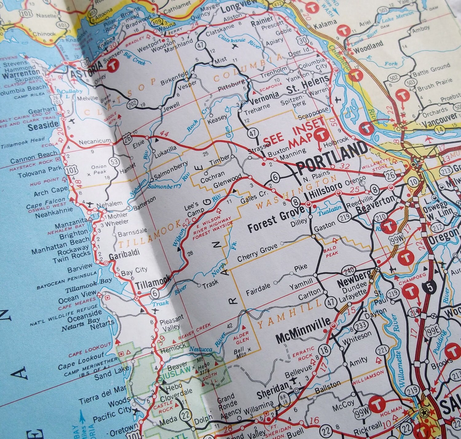
On this map, how do you get to 150 W Oak street in McMinville? Or any restaurant in Portland while driving alone?
Why the needed "enhancement" if there are such things as maps and road signs other than being too lazy to read or take a minute or two before leaving to familiarize yourself?
Why be so narrow minded?
Why waste the minute or two?
How do you know he's "leaving" from a place that he can do that?
The thing is, people who rely on GPS don't learn to understand the big picture of a place. They only think about getting from point a to point b, and have no clue what the rest of the area is like or what the other possibilities are.
If you don't learn the bigger picture, how can you ever find anything in the future?
Use of GPS makes you more reliant on GPS makes you more reliant on GPS.
So? When the satellites go down and people are wandering lost in the streets, get back to us.
I use gps as a general guide. I rarely go places im not familiar with at all. They do come in handy for places up north where the roads are designed totally different than in the south.
You find a restaurant in Portland either by roaming around and stopping at one that looks good, or by looking up a specific one before you go and getting there easily based on your knowledge of the streets of Portland. I've only been to Portland once, but I'm sure I could find a specific restaurant just by looking it up on a map (electronic or paper) before I went, then just taking off and going. If someone calls during your journey and tells you to meet them at restaurant X, you get there by finding out the street address, then just going there.
You find a specific address on a specific street by having a picture of the streets of Portland (or wherever) in your head and going straight there easily without any effort whatsoever. OP is right about the grid system (although the hearts of very old cities like Boston are based on waterways rather than the grid).
When I lived in LA I loved my Thomas guide.
I carry various state maps with me in the drawer under the passenger seat. I don't often look at them, though.
Two years ago I drove from my home in Minnesota to a really obscure place in Illinois, without using any maps at all on the drive. I knew how to get there because I had looked at some on-line maps earlier. Just "looked at", not "studied and panicked over." Not detailed "take a right on exit 42" maps, just general road maps. It was a really fun trip! I stopped at things that looked interesting and took some roads because they looked pretty. Got to my destination without a hitch. Come to think of it, I do this a lot. I just met someone for business reasons at a small restaurant in a small town about 3 hours away. Never been there before. Looked it up before I went, but didn't bother to take a map with me.
"But how will I ever find a restaurant in Portland without GPS, wah?" (snickers again.)
Last edited by 601halfdozen0theother; 09-01-2016 at 02:34 PM..
Goody for you. Even before there were smartphones, most people did not have a perfect picture in their mind of all the streets in their town. Those people had to ask for detailed directions both beforehand and along the way, often got lost, and found it stressful to drive to unfamiliar places. Now they can follow their navigation unit or smartphone app. It sounds like you are just upset that your mapping skills and knowledge have been rendered largely obsolete and your advantage over those people has been greatly diminished.
Despite my name , I'll probably be collecting non-functional GPS devices to sell for rare earth metals.
Jokes aside, your "big picture" comment is spot-on. American cities were planned with ease of navigation in mind. And I mean actual cities, not exurban subdivisions with streets winding every which way. All cities older than 100 years,at least the ones on built on flat terrain, have some semblance of a grid. (A grid is harder to lay out when there are hills in the way, and streets need to curve around bodies of water.) Complete with zero points (where numbers start from) and a logical numbering system. Master that, and you can get around anywhere in your city, with just basic reading skills and knowing which compass direction (N, S, E, W) you're facing.
Las Vegas is a tight town/range/section layout. Streets are on the section and subsection lines and have the same name all across town. A little hooker though. Virtually none are continuous particularly on the second and third levels. The street we live on has at least 7 segments...none of which connect and even some of the section roads are very segmented as you get out of town.
So GPS works great. Finding the street however not so great. Merely being at 2000 Smith does not mean easy access to 3000 Smith. May take a couple of multi mile detours.
It sounds like you are just upset that your mapping skills and knowledge have been rendered largely obsolete and your advantage over those people has been greatly diminished.
If what you're saying is true, then why not eliminate street names and highway numbers? Naming streets is for luddites who still compare them against maps and compass directions. Let's give each building a hexadecimal unique identifier number (shown only inside the GPS, not on the buildings themselves), and let people drive on nameless streets and "turn right in a quarter mile" when their GPS tells them to. It's new, it's modern, it's cutting-edge.
But if we do that, how will we commemorate our past presidents?
Last edited by MillennialUrbanist; 09-01-2016 at 03:42 PM..
Please register to post and access all features of our very popular forum. It is free and quick. Over $68,000 in prizes has already been given out to active posters on our forum. Additional giveaways are planned.
Detailed information about all U.S. cities, counties, and zip codes on our site: City-data.com.

 Please register to participate in our discussions with 2 million other members - it's free and quick! Some forums can only be seen by registered members. After you create your account, you'll be able to customize options and access all our 15,000 new posts/day with fewer ads.


 , I'll probably be collecting non-functional GPS devices to sell for rare earth metals.