Please register to participate in our discussions with 2 million other members - it's free and quick! Some forums can only be seen by registered members. After you create your account, you'll be able to customize options and access all our 15,000 new posts/day with fewer ads.
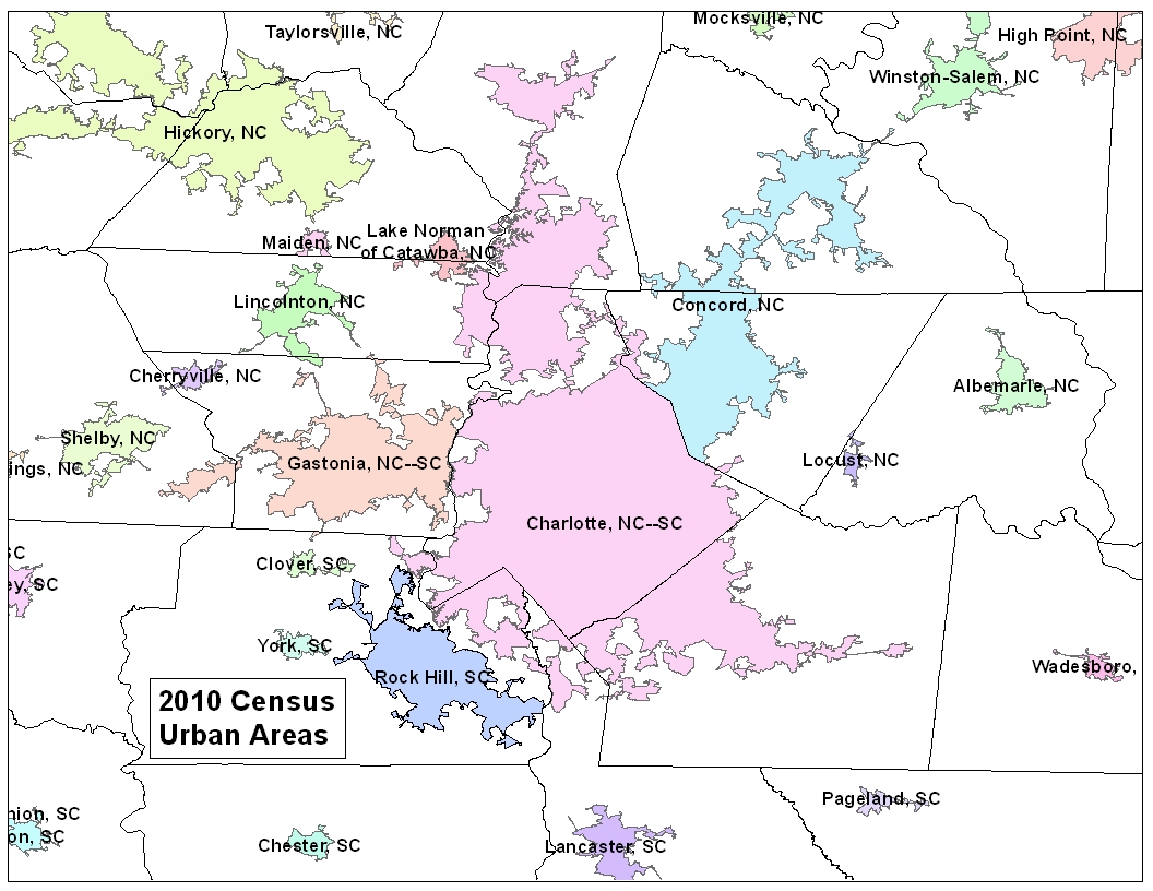
For this area, the Charlotte urbanized area now takes in Mooresville, Statesville, Wingate, parts of Indianland in Lancaster County, and Lake Norman areas of Lincoln County. This means at least that Iredell County will be added to the Charlotte metropolitan area.
Concord now takes in Salisbury, which means that Rowan and Cabarrus Counties will be in the same metropolitan area. They may or may not be in the Charlotte area.
The boundary between the Charlotte and Concord urbanized areas was revised to place Harrisburg in the Concord urbanized area.
This assigns Gastonia to Charlotte, Lincolnton to Gastonia, & Shelby to Gastonia. Assigning Shelby would be assigning the micropolitan to Gastonia because of Kings Mountain.
Last edited by southbound_295; 03-26-2012 at 11:15 AM..
Unfortunately, the only way to see the boundaries so far is to download shapefiles and view them in GIS, like ArcMap, and not many people have GIS.
This is from the press release: "Among urbanized areas with populations of 1 million or more, the Charlotte, N.C.-S.C., area grew at the fastest rate, increasing by 64.6 percent, followed by the Austin, Texas, area, at 51.1 percent, and Las Vegas-Henderson, Nev., at 43.5 percent. The Charlotte and Austin areas also had the highest rates of land area change, increasing by 70.5 percent and 64.4 percent, respectively."
Location: The place where the road & the sky collide
23,809 posts, read 34,443,504 times
Reputation: 10256
Quote:
Originally Posted by NCDave
Unfortunately, the only way to see the boundaries so far is to download shapefiles and view them in GIS, like ArcMap, and not many people have GIS.
This is from the press release: "Among urbanized areas with populations of 1 million or more, the Charlotte, N.C.-S.C., area grew at the fastest rate, increasing by 64.6 percent, followed by the Austin, Texas, area, at 51.1 percent, and Las Vegas-Henderson, Nev., at 43.5 percent. The Charlotte and Austin areas also had the highest rates of land area change, increasing by 70.5 percent and 64.4 percent, respectively."
According to the page that I found, Salisbury micropoltan & Thomasville/Lexington Micropolitan were assigned to Concord. That means that assigning Shelby to Gastonia was not assigning the whole micropoltan, but everything between Shelby & Gastonia on 74 is Kings Mountain. Shelby's population is 22K+ & City of Kings Mountain is 11K+. The Kings Mountain zipcode, which is in Cleveland & Gaston Counties is 28K+ What did you see?
Unfortunately, the only way to see the boundaries so far is to download shapefiles and view them in GIS, like ArcMap, and not many people have GIS.
This is from the press release: "Among urbanized areas with populations of 1 million or more, the Charlotte, N.C.-S.C., area grew at the fastest rate, increasing by 64.6 percent, followed by the Austin, Texas, area, at 51.1 percent, and Las Vegas-Henderson, Nev., at 43.5 percent. The Charlotte and Austin areas also had the highest rates of land area change, increasing by 70.5 percent and 64.4 percent, respectively."
I read that press release in the CBJ. The title was misleading in that it suggested our population had grown, rather than the definition of what Charlotte is had changed.
From the CBJ article:
Charlotte also had the highest rate of land-area change, increasing by 70.5 percent to encompass 1.9 billion square miles.
Hmm, urbanized areas and MSAs are two different concepts, with different definitions. MSA counties are determined by commuting patterns, whereas urbanized areas are defined as densely developed residential, commercial and other nonresidential areas, regardless of commuting patterns. It is quite possible for Mooresville to be part of Charlotte's urbanized area, but not its MSA.
Charlotte also had the highest rate of land-area change, increasing by 70.5 percent to encompass 1.9 billion square miles.
So CBJ is reporting that Charlotte has grown to 1.9 billion square miles?
I knew they like to push the Charlotte boosterism, but this exceeds the entire surface area of the earth by several times. Maybe they think parts of Mars in in the city limits now.
Here are the Charlotte area urbanized areas and urban clusters.
Counties with at least 50% of their population in an urbanized area qualify as central counties of a metropolitan statistical area. Because of the expansion of the Charlotte urbanized area to include Mooresville and Statesville, Iredell County will be a central county along with Mecklenburg and Union. Other counties qualify as outlying based on communting to those counties. Gaston, York, Cabarrus, Rowan, Anson, and possibly Lincoln, Stanly, and Lancaster could be in the metropolitan area once the new delineations are announced next year.
So CBJ is reporting that Charlotte has grown to 1.9 billion square miles?
I knew they like to push the Charlotte boosterism, but this exceeds the entire surface area of the earth by several times. Maybe they think parts of Mars in in the city limits now.
Maybe!
Shouldn't we expect that anyone writing for the CBJ would know that 1.9 Billion square miles is many times the surface area of the whole planet??
A quick check says that the surface of the earth is ~1.97 million square miles. So maybe that's where the number came from, Still two levels of wrong though.
Please register to post and access all features of our very popular forum. It is free and quick. Over $68,000 in prizes has already been given out to active posters on our forum. Additional giveaways are planned.
Detailed information about all U.S. cities, counties, and zip codes on our site: City-data.com.

 Please register to participate in our discussions with 2 million other members - it's free and quick! Some forums can only be seen by registered members. After you create your account, you'll be able to customize options and access all our 15,000 new posts/day with fewer ads.