Please register to participate in our discussions with 2 million other members - it's free and quick! Some forums can only be seen by registered members. After you create your account, you'll be able to customize options and access all our 15,000 new posts/day with fewer ads.
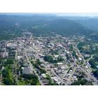
I don't know if anyone has mentioned it previously, but I just noticed that Google Maps has just updated with Charlotte being added to the list of American cities that has the "street view" feature activated.
The feature allows you to view buildings from street-level, with 360 degree swivel control - basically taking mapping to the next level.
I imagine that this tool will be particularly useful to members of this board, as people can accompany their posts with street-level images of what they are referring to!
Make sure that the "Street View" tab is activated and then you can 'click and drag' the small orange icon to any location that is highlighted in blue in order to access a street-level view.
Very cool! I knew Google had this feature but didn't realize it had come to Charlotte.
Not the best shot of my house but I do know what day of the week the picture was taken........it was Friday. How do I know? .........trash pick up day, my trash can and recycle bin are still on the street!
Yea I thought it was pretty cool too.
Does anyone have any idea how they are doing this?
Are people actually taking pictures or is it a video?
It is a VW Beetle that drives around, clearly marked with a roof mounted camera that takes 360 degree view.
Has been seen in the Asheville area (yes mods, I know this is the Charlotte thread) early this year. Judging from fall colors and gas prices in Charlotte it looks like it takes about 8 months or so before being placed online.
Actually, the satellite image I see is older than 8 months- probably more than 15. The image of my house doesn't show our swing set which we put up on Easter weekend 07.
Actually, the satellite image I see is older than 8 months- probably more than 15. The image of my house doesn't show our swing set which we put up on Easter weekend 07.
I think the satellite images are circa 2006 for most areas.
Actually, the satellite image I see is older than 8 months- probably more than 15. The image of my house doesn't show our swing set which we put up on Easter weekend 07.
i think they are referring to the STREET VIEW camera, not the satellite camera.
Judging by the for sale sign in front of my house, the pictures of my address were probably taken last summer. I bought it very shortly after it went on the market, and I closed in August.
Please register to post and access all features of our very popular forum. It is free and quick. Over $68,000 in prizes has already been given out to active posters on our forum. Additional giveaways are planned.
Detailed information about all U.S. cities, counties, and zip codes on our site: City-data.com.

 Please register to participate in our discussions with 2 million other members - it's free and quick! Some forums can only be seen by registered members. After you create your account, you'll be able to customize options and access all our 15,000 new posts/day with fewer ads.


")