Please register to participate in our discussions with 2 million other members - it's free and quick! Some forums can only be seen by registered members. After you create your account, you'll be able to customize options and access all our 15,000 new posts/day with fewer ads.
This is an interesting topic and good find. I just think it is important to understand the different structures of different metros.
Atlanta's main population starts in Atlanta and goes north. There is not that much deveopment in south Atlanta probably b/c the airport compared to north. If you take the radius and shift in 15 miles north that sould get a bulk of the population, but regardless its an interesting metric.
Based on the Google map, a few posts back the Atlanta index point looks to be a little nort of Midtown, but not as far as you are suggesting, looks like about 3 or 4 miles from downtown based on what I could tell
Multiple cores also plays in, Is a trickier one than any other because even those that have a water feature usually only impacts one side. the Bay Area has the bay and the Ocean
This Map of UA demonstrates what you are saying but yet it does spread so many areas are very far from other areas, maybe why dense it lacks the cohesion of other areas
SF UA (Scale 185 Miles)
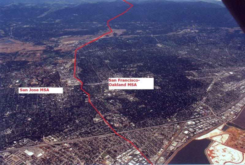
Once you leave the SF UA or MSA, the development and relatively high diversity does not drop off.
I made this pic a while back to illustrate that. Coincidentally the border between the SF UA and SJ UA is the same as the Metro Borders.
For the most part, but as another just posted, the metro population goes in an arc northwest to southeast with the bulk being on the northside. To the southwest it is barely developed and mostly rural, even in Fulton County.
Once you leave the SF UA or MSA, the development and relatively high diversity does not drop off.
I made this pic a while back to illustrate that. Coincidentally the border between the SF UA and SJ UA is the same as the Metro Borders.
but look at it this way, one of the few places you can walk to another city for lunch
I remember this picture, there is a similar dynamic north of Philly at the Bucks County/Mercer County line at Trenton - I have been looking for a pic similar to this since I saw yours, good stuff and a perfect example of how stats can't always tell the whole strory (Obviously the areas on either side of the red line have no cohesion...)
For the most part, but as another just posted, the metro population goes in an arc northwest to southeast with the bulk being on the northside. To the southwest it is barely developed and mostly rural, even in Fulton County.
regardless that population lives more than 50 miles from the core, but yes agree no measure can perfectly account for the real world
but look at it this way, one of the few places you can walk to another city for lunch
That is highly uncommon even in the NY Urban Area that someone in a suburban area near the border of another metro area or urban area would walk to another suburban town a county over for lunch.
SF and SJ are not combined because there isnt a 3+mile overlap of housing development, which is the requirement if metros don't meet that 25% commuter requirement.
It stops at 2.7 Miles due to the Stanford Shopping Center and the Stanford University Linear Accelerator.
Now that's a bitter pill that we must swallow because of the federal guildelines but that doesnt mean that there isnt any cohesion.
Obviously there is a lot of cohesion as SF and SJ are combined into a single CSA.
But this topic is one that we will continue to all debate until the OMB wakes up and realizes that localities such as Metro Philly and The Bay Area know better how their region is defined and not stuffy statisticians in DC...LOL
I guess you are not getting what I'm saying. The direction in which that 50 miles is drawn is the important bit. But, whatever.
No I followed 100% - you are not following, if you agree that the station is a somewhat close assemblance of the core (meaning the center of the city) then 50 miles from there is 50 miles from there (meaning to drive to that location in the middle of Atlanta is still 50 miles, or to stadiums, DT, midtown, museums, the aquarium or even the airport). I mean honestly 50 miles is a pretty damn far distance. So regardless that is still the distance to the place where the name of MSA resides or the core city and core part of that city
Here is the MSA Map (Scale 185 miles across) It extends beyond a 50 mile radius
So yes it touches the Austin MSA at 50 miles but misses the population center by a large distance, also it apears 5 of the counties included have areas outside of the 50 mile radius (the address is noted and identified in the google map link and looks visually pretty geographically centered)
Bexar county has 1.7 million people and is not over a 25 mile radius.
I just went back to the map and there in deed are parts of Bexar county more than 25 miles from the station
Also the data is nearly 3 years old so it may be a little light on counts
Please register to post and access all features of our very popular forum. It is free and quick. Over $68,000 in prizes has already been given out to active posters on our forum. Additional giveaways are planned.
Detailed information about all U.S. cities, counties, and zip codes on our site: City-data.com.

 Please register to participate in our discussions with 2 million other members - it's free and quick! Some forums can only be seen by registered members. After you create your account, you'll be able to customize options and access all our 15,000 new posts/day with fewer ads.