Please register to participate in our discussions with 2 million other members - it's free and quick! Some forums can only be seen by registered members. After you create your account, you'll be able to customize options and access all our 15,000 new posts/day with fewer ads.
I remember this one time, I got from Woodland Hills to Newport Beach in a record 45 minutes. That time also coincided with Carmageddon.
Yesterday, I decided to drive into work. For about 15 miles, I went a very excellent speed of around 10 mph (between CA-170 and the I-110 interchange along US 101). What an excellent and constructive use of my time!
I wouldn't say that traffic is bad all the time. I bet if I left right now and I drove in, I could actually drive 65-70 the whole way home. Unfortunately, I need a job, and that wouldn't fly at all.
That's true, sometimes my wife plays soccer in the South Bay and gets home in about 30-45 minutes - that's about the only time the downtown exits on 110 east of DTLA make any sense to me.
Of course when she drives home from DTLA at 5PM it takes 45 minutes to drive 7 miles.
That's true, sometimes my wife plays soccer in the South Bay and gets home in about 30-45 minutes - that's about the only time the downtown exits on 110 east of DTLA make any sense to me.
Of course when she drives home from DTLA at 5PM it takes 45 minutes to drive 7 miles.
Yeah, there was a CD poster that said I should drive instead of take PT because it apparently takes 2 hours according to Google Maps, even though it only takes me 1 hr to get from home to work using PT (as if I'd actually lie about something like that). It's not great, but its at least stable.
I wouldn't wish driving in rush-hour LA traffic without using the carpool lane on anyone. I hope no one takes relocation and commute advice from City vs City.
The worst part about DTLA at 5 PM is the fact that none of the lights here are coordinated, making what really isn't awful traffic that much more daunting. I was stuck on Fig and 7th for around 10 minutes because of that (there's a light a few feet away on 7th and Francisco..one was green and one was red...)
I guess I haven't driven on the freeways in many cities... I felt like it was higher in Boston along 93 and 90 (I'm guess 65 MPH) and that is about what it is on most freeways in LA like 405 and 110S. Of course around Central LA traffic is so bad you never get a chance to get above 45 MPH anyways
The only major cities I've driven in (as opposed to be a passenger in a car or just using transit) are Boston and New York City.
All freeways in Long Island are 55 mph as are much of the rest of the metro. All freeways within New York City have no more than a 50 mph speed limit, a few are lower.
Yeah I learned a lot too like subways weren't meant for areas of the country where hurricanes & mass flooding are likely.
LA doesn't have to worry about that though just brush fires, landslides, & earthquakes.
But if the majority of the people don't live in the mountains (which you contended earlier), why does it matter to the rest of us? Brush fires, by definition, can't happen in areas without brush, which most of the flat areas of LA don't have. Landslides also can't happen, by definition, in flat areas.
But if the majority of the people don't live in the mountains (which you contended earlier), why does it matter to the rest of us? Brush fires, by definition, can't happen in areas without brush, which most of the flat areas of LA don't have. Landslides also can't happen, by definition, in flat areas.
So which is it?
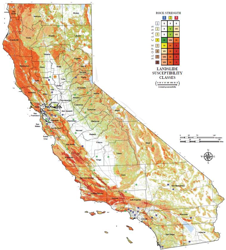
Here, argue with Ca.gov since you think you're so smart. Turns out the this landslide maps red danger zone slices right through the LA Basin on up the coast of California.
Here argue with these people since you think you're so smart. Turns out the this landslide maps red danger zone slices right through the LA Basin on up the coast of California.
How can something be downward but also be flat? Just take your loss and move on. You have no clue what you're talking about.
I see you bothered to read the disclaimer below it of which the second map illustrates.
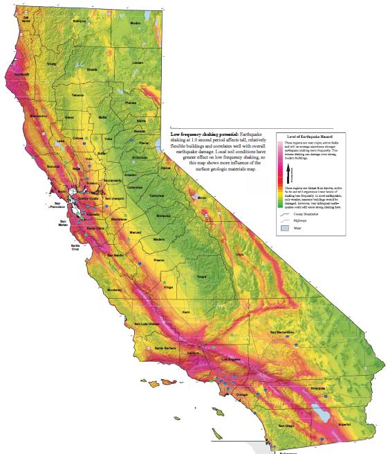
This is a susceptibility map, not a hazard map. In other words, it does not take into consideration the occurrence of triggers of the potential landslides, which of course in this area are both intense rainfall and earthquakes.
I see you bothered to read the disclaimer below it of which the second map illustrates.
This is a susceptibility map, not a hazard map. In other words, it does not take into consideration the occurrence of triggers of the potential landslides, which of course in this area are both intense rainfall and earthquakes.
You failed, move on.
So conjoin it with this map:
Where the LA Basin is second from the bottom on the scale. Gotcha
I'm glad we went through that exercise. You sure put me in my place.
Please register to post and access all features of our very popular forum. It is free and quick. Over $68,000 in prizes has already been given out to active posters on our forum. Additional giveaways are planned.
Detailed information about all U.S. cities, counties, and zip codes on our site: City-data.com.

 Please register to participate in our discussions with 2 million other members - it's free and quick! Some forums can only be seen by registered members. After you create your account, you'll be able to customize options and access all our 15,000 new posts/day with fewer ads.