Please register to participate in our discussions with 2 million other members - it's free and quick! Some forums can only be seen by registered members. After you create your account, you'll be able to customize options and access all our 15,000 new posts/day with fewer ads.
Seattle has always struck me as a city that's absolutely built for rail transit, but for some reason hasn't had any until recently.
Yeah, in 1970 Seattle had secured federal funding for a massive subway system, but the people voted it down. At that time, Seattle was a blue collar port town that largely relied on Boeing for economic survival. After Boeing laid a huge chunk of their workforce off in the lat 1960s, people panicked and were less willing to support a huge investment like that (a 60% supermajority was required, but it only recieved 50%) 1967 Seattle-area transit plan | Slumberland
However, currently there are plans in the works for a very robust system to develop over the next two decades. It will incrementally keep getting better, but for now covers a relatively low density portion of the City so ridership is low.
However, currently there are plans in the works for a very robust system to develop over the next two decades. It will incrementally keep getting better, but for now covers a relatively low density portion of the City so ridership is low.
Not a low density portion of the city, but not the most common sense route for the initial line. Seattle's line and ST's district are both a gerrymandered political mess. Seattle should have built a north line first. They are real lucky the high costs, cost overruns, misuse of ST funds, etc. did not kill off any further growth to the system.
Location: The Greatest city on Earth: City of Atlanta Proper
8,485 posts, read 14,987,215 times
Reputation: 7328
Quote:
Originally Posted by orzo
Yeah, in 1970 Seattle had secured federal funding for a massive subway system, but the people voted it down. At that time, Seattle was a blue collar port town that largely relied on Boeing for economic survival. After Boeing laid a huge chunk of their workforce off in the lat 1960s, people panicked and were less willing to support a huge investment like that (a 60% supermajority was required, but it only recieved 50%) 1967 Seattle-area transit plan | Slumberland
However, currently there are plans in the works for a very robust system to develop over the next two decades. It will incrementally keep getting better, but for now covers a relatively low density portion of the City so ridership is low.
Another side effect of this is, when Seattle voters voted "No" for rapid transit, it cleared the way for Atlanta to receive enough funds to build MARTA which voted to approve building a rapid transit system in 1971. Basically, because Seattle didn't build a subway, Atlanta got one. Thanks Seattle!
Edit:
That's that proposed Seattle subway map looked like it would have been amazing if it had been built. Thanks for sharing!
Does anyone have a map of the proposed Houston subway that supposed to be built in the 1980s but never got off the ground? I've been looking for that for years.
Not a low density portion of the city, but not the most common sense route for the initial line. Seattle's line and ST's district are both a gerrymandered political mess. Seattle should have built a north line first. They are real lucky the high costs, cost overruns, misuse of ST funds, etc. did not kill off any further growth to the system.
I'm not saying it wasn't the right decision politically and fiscally, but come on - Beacon Hill, Rainier Beach, Othello,Tukwila. Those areas are relatively low density, especially when you compare them to places the light rail will be in the next decade: Capitol Hill, U District, Roosevelt, Northgate, Downtown Bellevue, etc.
I'm not saying it wasn't the right decision politically and fiscally, but come on - Beacon Hill, Rainier Beach, Othello,Tukwila. Those areas are relatively low density, especially when you compare them to places the light rail will be in the next decade: Capitol Hill, U District, Roosevelt, Northgate, Downtown Bellevue, etc.
In the mid 90's the density of those neighborhoods were as dense or denser than most Seattle neighborhoods with the exception of First/Capitol Hill, the U-District, and a few other areas close to downtown. The area also had the highest levels of existing transit use at the time.
The area didn't lack density, it lacked major destinations. Until the line connected to the airport, it pretty much just took neighbors off the bus and onto a significantly more expensive mode of transportation.
The north line should have been the initial line due to:
- geography; ship canal limits egress and ingress from dense north Seattle neighborhoods and beyond to downtown
- limits in existing transportation system; north and translake provide the least amount of lanes into central Seattle compared to from the south
- major destinations; linking UW to downtown, already by far the most used transit corridor in the city would have meant large initial ridership numbers
In the mid 90's the density of those neighborhoods were as dense or denser than most Seattle neighborhoods with the exception of First/Capitol Hill, the U-District, and a few other areas close to downtown.
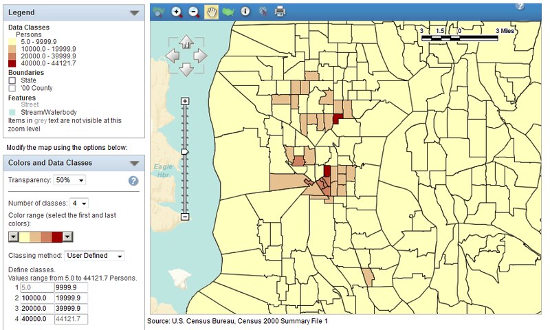
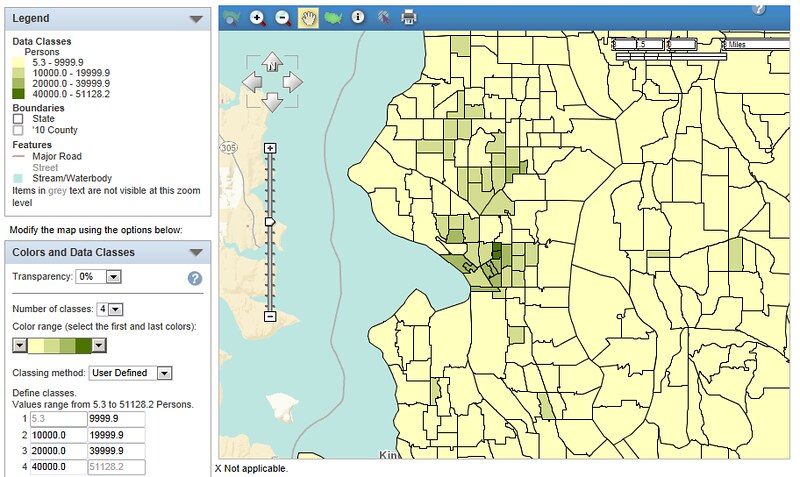
Eh, I don't know about that. Look at these density maps from 2000 and 2010. The areas the light rail goes through is bright yellow (i.e. low density), with the exception of Columbia City.
Eh, I don't know about that. Look at these density maps from 2000 and 2010.
ST was planned in the mid 90's using 1990 census data. Northgate, Ballard, and DT Bellevue had yet to see their multi-unit residential boom, and Belltown was just starting to grow. Northgate was on the map for being the #2 commercial center in Seattle and a natural point for an end of the line park & ride. U-District, Capitol Hill, First Hill, Beacon Hill, and Rainier Valley were all part of the initial plan, but as voters continually voted down the plan, ST had to pare down both their initial plan and their district.
Again, the area did not lack population nor population density: statistically it was one of the densest places in the entire state. It was lack of significant destinations until it connected to the airport that made it the lesser choice for the initial line. Meanwhile the north line will connect to major destinations like Capitol Hill, Husky Stadium, and the Univ. of Washington. The population density of Montlake is tiny compared to Seattle as a whole, but it will be a busy station being near to UW's sports venues and massive health care complex.
Please register to post and access all features of our very popular forum. It is free and quick. Over $68,000 in prizes has already been given out to active posters on our forum. Additional giveaways are planned.
Detailed information about all U.S. cities, counties, and zip codes on our site: City-data.com.

 Please register to participate in our discussions with 2 million other members - it's free and quick! Some forums can only be seen by registered members. After you create your account, you'll be able to customize options and access all our 15,000 new posts/day with fewer ads.