Please register to participate in our discussions with 2 million other members - it's free and quick! Some forums can only be seen by registered members. After you create your account, you'll be able to customize options and access all our 15,000 new posts/day with fewer ads.
From what I've seen on Google Maps and from what I've heard is, Chicago has alot of urban prairies on the south and west-sides away from its core and away from the lake.
There are definitely select areas on the south/west sides that have a lot of vacant lots - but not really on the level of urban prairies. I was in Detroit last weekend and saw some of the urban prairies, which were tall overgrown areas that went on forever with just a few occupied and normally abandoned houses. Streets were basically shut down, sidewalks grown over and no cars or people anywhere. Chicago's housing is very much intact for its total population slide. The city increased housing units every census on record except for 2010 when the number slid 1.4%. It's mostly just empty lots that dot areas, although they're fairly free of debris, are mowed and the surrounding sidewalks/streets/infrastructure are kept in place.
The west side areas of vacancy is somewhat small in area, normally thought of as East/West Garfield Park and North Lawndale. Some of the more vacant places:
South side OVERALL is very intact, but there are key areas around Englewood and Washington Park. So yes, tons of vacant lots and empty areas, but norally it's on commercial streets that things REALLY look terrible and might give an impression of more abandonment than if you venture over to the residential side streets. I'm still always surprised overall at the degree things are still in place when driving through south/west side areas. In my head I expect more vacant land for the population slide. Much of the population loss is families replaced by elderly or single people/couples.
I find it so hard to believe that Chicago is between 3rd and 5th when it comes to population density, considering that its infrastructural density SEEMS to be easily #2, if not #3! I've been to LA, SF, etc. and don't see where those cities have the infrastructure and density that Chicago does in the core 1, 3, 5, or more miles. I realize that household size may vary a bit, but c'mon......it just doesn't add up to me!
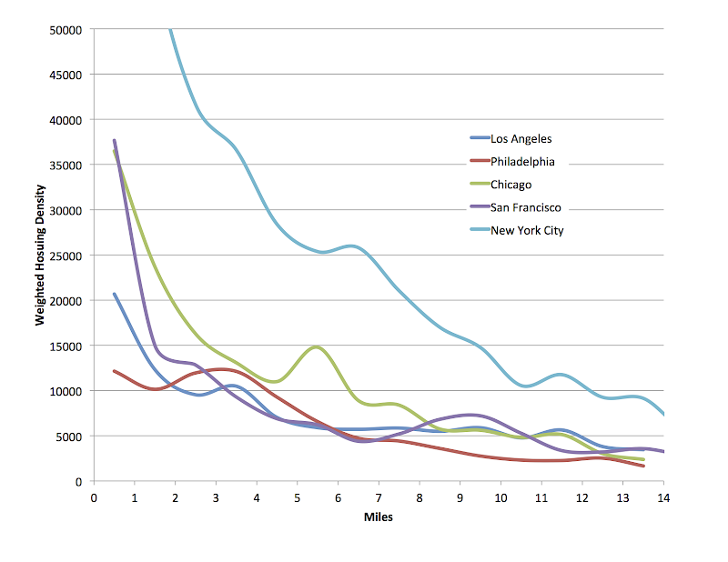
I made similar graphs for weighted housing density. This should make it clear what's going on. There are two differences between my graphs and the census graphs:
1) The center point isn't city hall, but the location I could find that would give the highest weighted central densities — for Chicago it's in the Old Town / Gold Coast not the Loop, for New York City it's the Upper East Side (2nd Ave and 81st; ton of high rises there, and anything not a high rise is a 5-6 story tenement unlike Chicago high rise districts), for Philadelphia, the densest districts are in the "downtown district" (I picked Rittenhouse Square), for Los Angeles, Wilshire Center (4th St and Catalina), for San Francisco, near the Tenderloin (Geary & Hyde)
2) My points are slightly different. I calculated weighted density between integer mile values (so between 1-2 miles with a point at 1.5 mile, between 2-3 miles with a point at 2.5 miles, and a smoothed line connects them). The census calculates all whose distance round to the same integer (so data point at 2 would be those at a distance of 1.5-2.5 miles)
Anyhow, graph of weighted housing densities. New York City maxes out at 87k/sq mile in the Upper East Side.
Weighted population densities at the same distance, so as to see the effect of household size. New York City maxes out at 137k/sq mile in the Upper East Side.
There are definitely select areas on the south/west sides that have a lot of vacant lots - but not really on the level of urban prairies. I was in Detroit last weekend and saw some of the urban prairies, which were tall overgrown areas that went on forever with just a few occupied and normally abandoned houses. Streets were basically shut down, sidewalks grown over and no cars or people anywhere. Chicago's housing is very much intact for its total population slide. The city increased housing units every census on record except for 2010 when the number slid 1.4%. It's mostly just empty lots that dot areas, although they're fairly free of debris, are mowed and the surrounding sidewalks/streets/infrastructure are kept in place.
The west side areas of vacancy is somewhat small in area, normally thought of as East/West Garfield Park and North Lawndale. Some of the more vacant places:
South side OVERALL is very intact, but there are key areas around Englewood and Washington Park. So yes, tons of vacant lots and empty areas, but norally it's on commercial streets that things REALLY look terrible and might give an impression of more abandonment than if you venture over to the residential side streets. I'm still always surprised overall at the degree things are still in place when driving through south/west side areas. In my head I expect more vacant land for the population slide. Much of the population loss is families replaced by elderly or single people/couples.
I think the point is though, when comparing Chicago to the Bay and Los Angeles, these sorts of open empty spaces do not develop. Certainly Chicago is not to the level of Detroit or other abandoned post-industrial cities. But in LA and the Bay the most you will see is a single empty lot, rarely do you see consecutive lots which start to have the appearance of an urban prairie. Additionally, Chicago probably just has a greater number of individual derelict/empty lots compared to Los Angeles and the Bay Area, which have seen their population numbers maintained and even increased through rapid immigration (keeping tenants in what would be derelict buildings in some other cities).
There are definitely select areas on the south/west sides that have a lot of vacant lots - but not really on the level of urban prairies. I was in Detroit last weekend and saw some of the urban prairies, which were tall overgrown areas that went on forever with just a few occupied and normally abandoned houses. Streets were basically shut down, sidewalks grown over and no cars or people anywhere. Chicago's housing is very much intact for its total population slide. The city increased housing units every census on record except for 2010 when the number slid 1.4%. It's mostly just empty lots that dot areas, although they're fairly free of debris, are mowed and the surrounding sidewalks/streets/infrastructure are kept in place.
The west side areas of vacancy is somewhat small in area, normally thought of as East/West Garfield Park and North Lawndale. Some of the more vacant places:
South side OVERALL is very intact, but there are key areas around Englewood and Washington Park. So yes, tons of vacant lots and empty areas, but norally it's on commercial streets that things REALLY look terrible and might give an impression of more abandonment than if you venture over to the residential side streets. I'm still always surprised overall at the degree things are still in place when driving through south/west side areas. In my head I expect more vacant land for the population slide. Much of the population loss is families replaced by elderly or single people/couples.
How the hell does Houston have 19,000 ppsm at the 0-1 mile point? It' downtown is almost all office towers and I doubt the apartment/SFH have 19,000 people living in them within 1 mile of city hall...I don't see it being denser than Miami at the core, especially weighted.
Well I'm confused because it says weighted density from City Hall yet the website says :Population density in rings moving out from the central business ditrict. Which is it? Because Miami's city hall is nowhere near downtown!
In fact Miami's city hall is in a refurbished Pan Am seaplane hangar in Coconut Grove which is primarily full of single family homes & is several miles from downtown itself.
Is everybody else's City Hall located downtown?
Good point, Miami's City Hall is indeed away form downtown. And going north from C. Grove the density heavily intensifies esp. Because it goes through Little Havana.
So, I guess many people on here have been wrong about the density for their cities compared to other cities according to this. Shows you can't always believe what people claim.
There's two kinds of densities though:
1. population density (which you can't always see)
2. infrastructural density (which is what you can see)
The kinds of density most people seem to talk about here on C-D when calling one place "urban" and another "sprawling" is the latter.
I made similar graphs for weighted housing density. This should make it clear what's going on. There are two differences between my graphs and the census graphs:
1) The center point isn't city hall, but the location I could find that would give the highest weighted central densities — for Chicago it's in the Old Town / Gold Coast not the Loop, for New York City it's the Upper East Side (2nd Ave and 81st; ton of high rises there, and anything not a high rise is a 5-6 story tenement unlike Chicago high rise districts), for Philadelphia, the densest districts are in the "downtown district" (I picked Rittenhouse Square), for Los Angeles, Wilshire Center (4th St and Catalina), for San Francisco, near the Tenderloin (Geary & Hyde)
2) My points are slightly different. I calculated weighted density between integer mile values (so between 1-2 miles with a point at 1.5 mile, between 2-3 miles with a point at 2.5 miles, and a smoothed line connects them). The census calculates all whose distance round to the same integer (so data point at 2 would be those at a distance of 1.5-2.5 miles)
This explains everything to me, since it shows that the only city with higher infrastructural (housing) density than Chicago is NYC (duh), but Chicago's population density can and does fall below some of its peers because the avg. household size in Chicago's inner core is notably smaller than LA's, SF's, etc. This helps me understand why Chicago FEELS more urban than anywhere but NYC, yet the population stats don't necessarily show this.
Great job with the analysis, btw!!
Please register to post and access all features of our very popular forum. It is free and quick. Over $68,000 in prizes has already been given out to active posters on our forum. Additional giveaways are planned.
Detailed information about all U.S. cities, counties, and zip codes on our site: City-data.com.

 Please register to participate in our discussions with 2 million other members - it's free and quick! Some forums can only be seen by registered members. After you create your account, you'll be able to customize options and access all our 15,000 new posts/day with fewer ads.