Please register to participate in our discussions with 2 million other members - it's free and quick! Some forums can only be seen by registered members. After you create your account, you'll be able to customize options and access all our 15,000 new posts/day with fewer ads.
I was looking around on google maps a few days ago and the Apps are really beautiful. I still prefer the size, range, and diversity of the Rockies though
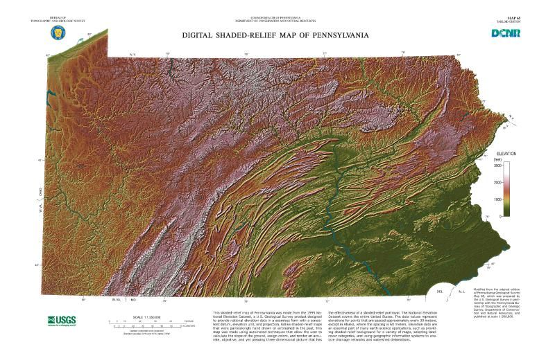
One thing I found out that's interesting is that the Geology department at the University of Georgia has two topographic maps: one of Georgia, and the other of Pennsylvania. What the mountains in Pennsylvania lack in absolute elevation, they compensate for in striking features and interesting geology. Here's a map:
You can see how difficult the terrain is in the Pittsburgh area despite not actually being located in the mountains. You can see why inland areas of northwestern Pennsylvania average more than 100" of snow per year, due to the quick rise in elevation from Lake Erie. You can see why northern Pennsylvania is so sparsely populated, due to the continuous high elevation and unforgiving terrain. You can see how severely folded and warped the ridge-and-valley region is in the central and south-central part of the state, with some really weird-looking mountain ranges, and you can also see how the Susquehanna River defies those mountains by flowing perpendicular to them. (It's actually one of the oldest rivers on the planet.) You can see the weird crescent-shaped valley that Scranton and Wilkes-Barre are located in, and how abruptly the Pocono Mountains rise to the east. You can see the southernmost extent of the New England Upland which separates the Lehigh Valley from greater Philadelphia, the northernmost extent of the Blue Ridge Mountains west of Gettysburg, and the Great Valley that travels between both of those geologic provinces and the rest of the Appalachian Mountains. You can see how flat and estuarine the Delaware Valley is from Philadelphia on south. Basically, you can see just how difficult the terrain is across most of the state, and, thus, how difficult it's been historically to build infrastructure across it as well. New York got lucky to have the Mohawk Valley as an area of easy passage.
Location: Appalachian New York, Formerly Louisiana
4,409 posts, read 6,536,583 times
Reputation: 6253
Quote:
Originally Posted by Craziaskowboi
One thing I found out that's interesting is that the Geology department at the University of Georgia has two topographic maps: one of Georgia, and the other of Pennsylvania. What the mountains in Pennsylvania lack in absolute elevation, they compensate for in striking features and interesting geology. Here's a map:
You can see how difficult the terrain is in the Pittsburgh area despite not actually being located in the mountains. You can see why inland areas of northwestern Pennsylvania average more than 100" of snow per year, due to the quick rise in elevation from Lake Erie. You can see why northern Pennsylvania is so sparsely populated, due to the continuous high elevation and unforgiving terrain. You can see how severely folded and warped the ridge-and-valley region is in the central and south-central part of the state, with some really weird-looking mountain ranges, and you can also see how the Susquehanna River defies those mountains by flowing perpendicular to them. (It's actually one of the oldest rivers on the planet.) You can see the weird crescent-shaped valley that Scranton and Wilkes-Barre are located in, and how abruptly the Pocono Mountains rise to the east. You can see the southernmost extent of the New England Upland which separates the Lehigh Valley from greater Philadelphia, the northernmost extent of the Blue Ridge Mountains west of Gettysburg, and the Great Valley that travels between both of those geologic provinces and the rest of the Appalachian Mountains. You can see how flat and estuarine the Delaware Valley is from Philadelphia on south. Basically, you can see just how difficult the terrain is across most of the state, and, thus, how difficult it's been historically to build infrastructure across it as well. New York got lucky to have the Mohawk Valley as an area of easy passage.
New York got lucky with the Mohawk valley and the finger lakes! As well as having all that Ontario coastline.
Still; there are a lot areas up here that were not accessible. The southern tier expy has been such a to-do because of the terrain for years and years. Notice central/western NY's population trends through the Mohawk valley and out onto the prairies; easy terrain, yet the southern tier and the Adirondacks are still both highly rural.
The cities of the southern tier exist mostly because of the finger lakes and nearby PA, but even then Elmira, Corning and Binghamton have nothing on the size and influence of Buffalo, Rochester and Syracuse.
Even up here you can see the terrain's historic influence on where people went to live in mass. Which only strengthens your point about PA's layout.
Ithaca though... that's a city I can't really explain. It's not huge per say but it's got a totally different urban atmosphere and general mind set from even the small towns right next to it. It is also much wealthier than any other southern tier city; I'd say mostly because of Cornell. It commands Tompkins county in people's minds but if you go just ten minutes south Tompkins is just like any other county in the area.
I am now curious as to how Ithaca/Cornell managed to thrive so much when its peer cities in the region struggled and continue to struggle. Seems terrain did not infringe on Ithaca much at all.
Just as an amusing aside; most of us southern tier natives identify far more closely with PA than the rest of NY. Could the similar terrain also play a part in this?
Far Out! hey everyone, thanks for coming...Far Out! I LOVE the Rockies...they are so very Far Out! I'm dedicating this to my best friend Annie. She is so Far Out! It makes me want to play my guitar and just sing out loud!...Although...I kinda like West Virginia too...feels like heaven....<hums a tune softly> wait, gotta go write down some words for maybe a new song.
The Appalachians are beautiful, but look more like hills than mountains to me.
Whatever guy. I lived in Alaska and even I consider these mountains. In fact, these look similar in prominence to many drives 'in the mountains' I've taken out west.
Whatever guy. I lived in Alaska and even I consider these mountains. In fact, these look similar in prominence to many drives 'in the mountains' I've taken out west.
Firstly, who is "Guy?" Secondly, I never said the Appalachians weren't mountains, I simply said they look like hills.
I never claimed you said they aren't mountains. I'm wondering why you would think the video I showed you look more like hills than mountains. They look like mountains to me and I lived in Alaska so it's not as if I'm a Floridian whose only gone as far as the Apps.
I never claimed you said they aren't mountains. I'm wondering why you would think the video I showed you look more like hills than mountains. They look like mountains to me and I lived in Alaska so it's not as if I'm a Floridian whose only gone as far as the Apps.
Actually, you did. You said "...even I consider these mountains," insinuating I don't consider the Appalachians a mountain range. I didn't bother watching the video because of that insinuation.
Please register to post and access all features of our very popular forum. It is free and quick. Over $68,000 in prizes has already been given out to active posters on our forum. Additional giveaways are planned.
Detailed information about all U.S. cities, counties, and zip codes on our site: City-data.com.

 Please register to participate in our discussions with 2 million other members - it's free and quick! Some forums can only be seen by registered members. After you create your account, you'll be able to customize options and access all our 15,000 new posts/day with fewer ads.