Please register to participate in our discussions with 2 million other members - it's free and quick! Some forums can only be seen by registered members. After you create your account, you'll be able to customize options and access all our 15,000 new posts/day with fewer ads.
Can anyone suggest a hiking trail in the Farmington vicinity that is steep and rugged (rocky would be nice too)? Need a trail to go do laps on during the weekend without driving too far simply to do laps. Maybe something that is difficult enough most people avoid it. Possibly within 30 minute drive?
Thinking about that north approach trail off of 185 to Talcott mountain (don't recall the spelling).
Talcott Mountain. 500 foot elevation gain. There's a tower with some good view from there. But it will get a little crowded if you go on weekends.
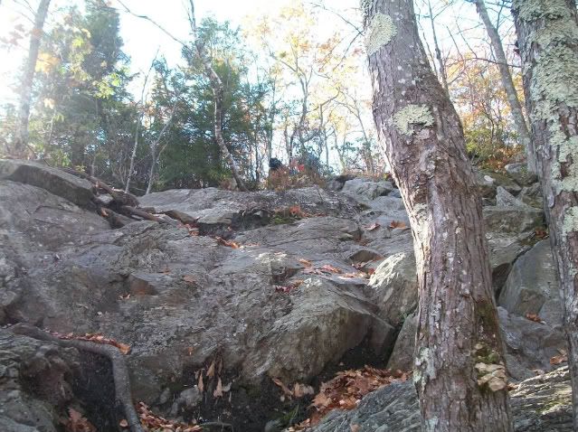
You want rocky? Try the highest peak in Connecticut...the hike starts with a big incline. The hike is pretty easy until the last 1/4 of it...Its pretty much a 60 degree rock climb.. Mt. Bear is the name..
If thats too far then maybe try Sleeping Giant in Wallingford. 32 miles of trails rugged and rocky and a four story tower on summit...it loops too. :-) 3-4 hr hike.. I'll be trying this one this year.. I did Mt. Bear and Greylock (tallest in MA)
Ragged Mountain in Berlin is awesome! It's an ACTUAL hike, as in, steep, rocky inclines, with no paved/gravel paths (though there are markers so you do not get lost). Talcott Mountain and Sleeping Giant, in my opinion, are "cupcake" hikes (literally a walk up a hill). Have fun and be safe!
Bear Mountain- tallest peak in CT with some challenging trails. IMO, Sleeping Giant is extremely easy and often extremely crowded on weekends. One trail is a wide path leading to the top. Enough said.
You should get a copy of the "connecticut walk book" it'll give you a map and basic overview of the trail and parking area. Also this way when you go out running you can copy the map and leave a copy so people know where to find you if you don't come back.
Excellant - Bear Mtn, Sleeping Giant, and Ragged Mtn it is then!
Thanks!
B
Take pics and keep a detailed memory or log of the trails and views. I'd love to hear about it.
Also keep in mind the weather. Spring is a tough time to go hiking due to Spring Rains and higher elevation snow melt which leads to mud at lower levels and deep brooks and rivers. Next 3 weeks is going to be tough weather wise so plan accordingly.
Please register to post and access all features of our very popular forum. It is free and quick. Over $68,000 in prizes has already been given out to active posters on our forum. Additional giveaways are planned.
Detailed information about all U.S. cities, counties, and zip codes on our site: City-data.com.

 Please register to participate in our discussions with 2 million other members - it's free and quick! Some forums can only be seen by registered members. After you create your account, you'll be able to customize options and access all our 15,000 new posts/day with fewer ads.