Please register to participate in our discussions with 2 million other members - it's free and quick! Some forums can only be seen by registered members. After you create your account, you'll be able to customize options and access all our 15,000 new posts/day with fewer ads.
This is a thread I've been wanting to do for a while.
So what are everyone's favorite places to go if you were going to go for a "Sunday drive" and see the sights close to home?
Not that I have time to do this myself (heck, I should be studying instead of being on here right now, but C-D makes for a nice study break haha), but here are some of my favorite drives:
- Oxford State Road between Excello and Cincinnati-Dayton in Middletown past AK. It's even cooler if you are coming from Route 4 and get off on Main st, which will loop you past the old paper mill right before you hit Excello. It's not "beautiful" in a traditional sense, more of a post-industrial wasteland at peace type of aura.
- Brown Street/Oakwood Blvd. from Wyoming to Far Hills. Neat transition from urban to college-town to old money in a short stretch.
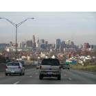
- Main St. from I-75 to US 35. The city looks and feels BIG going this way, especially up by Caresource. Doing the drive while listening to classical music by the Biltmore building, Victoria Theater, and the soldier's/sailor's monument almost takes you back to Dayton's prosperity of the 1920's in a way...
- US 35 on the east side of Dayton. Although the highway did severe damage to the neighborhoods, it shows a nice cross-section of the city.
- St. Rt. 41 through Troy. The route showcases Troy well with downtown, the courthouse, residential districts, Hobart, and the river.
- Salem Ave between downtown and Good Sam. Beautiful houses.
- St Rt. 503 between West Alexandria and Lewisburg. A nice creek follows it the entire way, and it's a beautiful drive. Plus West Alexandria is a very nice town.
Great idea for a thread! I'll be interested in everyone's answers since I'm only really familiar with my area.
Walk/hike: John Bryan and Clifton Gorge. Carriage Hill. Cox Arboretum for a nice picnic. Siebenthaler Fen for a quick stroll, particularly if I have a Ritter's milkshake .
Walk around town: Yellow Springs, or predictably, the Oregon District. I love Main street Fairborn around Halloween.
Bike or roller blade: Yellow Springs out to Young's or to Xenia on the bike path.
Drive: I agree with you about 35 East of Dayton. It's a really good view of the city.
Clifton Rd and through the town of Clifton.
In Beavercreek, East on Kemp rd. from Fairfield, then North on Beaver Valley.
571 from New Carlisle through Tipp City.
When I was a teenager, my boyfriend used to take me through Donnelsville, Springfield, and Mechanicsburg. I don't remember the route, but it made for a pretty drive.
My friends and I used to get from Fairborn to PKI by taking 235 into Xenia and then taking 42 'til it hit 48, which went right into Mason. It was a very scenic drive.
A lot of the roads in between Xenia and Beavercreek are pretty. Fairgrounds, Upper Bellbrook, etc.
Location: A voice of truth, shouted down by fools.
1,086 posts, read 2,702,997 times
Reputation: 937
Walking/Hiking: The main problem with John Bryan and Clifton Gorge is gross overuse. I love them but they're a PITA to walk on any decent day. A relatively undiscovered and more remote gem is Germantown Reserve. Twin Creek MetroPark which is adjacent in Carlisle is also a great park.
One of my favorite longer drives was 725 out through Miamisburg to Germantown, side trip to Germantown Reserve, then on to Gratis and Camden, the follow that valley south fo Camden to the road to Oxford, to visit the Miami U Art Museum in Oxford.
Another shorter drive is 725 to Bellbrook and on to Spring Valley, then down to Waynesville and back. Sort of mix of hills and river bottomland with country villages. An extension would be to Ceasars Trace for one of my favorite hikes...in the Cesars Creek Gorge (not by the dam)...then on to Oregonia.
Bikes
Out to Lytle and back. Road riding. One of my favorite rides...longish, but misses the rollers beyond Lytle, on the way to Waynesville.
the bike trail from Trotwood, through Brookville, and out to Verona is nice as it takes you through Midwest countryside
I like the bike path up to Tipp City and back. Bottomland riding, and along the river. I take the bus to Vandalia, catch the trail then ride up to Tipp and then down into the city....beyond, say, Needmore, not so nice since you are in sort of a bland landscape. So a qualified favorite.
In the city, Im liking the ride down from the Aldi in Westtown all the way down West Third into downtown. Wheee...downhill all the way.....
Bikes & Hikes
I also like riding out to St Leonard and Yeck Park and hiking Yeck Park or St Leonards little nature preserve. This is a good short daily ride that mixes biking with hiking.
Similar, and closer to me is biking to Grant Park (nature nook off McCewen) and doing a quick Grant Park hike.
Hikes
I used to like Germantown resereve for hiking, but too many memories of that with my late partner..it was one of our regular Sunday Drive destinations.....i start to get nostalgic and melancholy when I return there. The alternate is Twin Creek Metropark Park, which is a new good hike and not very busy either. Nice views of the Twin Creek valley from the higher parts (you can see the church steeples from Germantown, nestled in the valley)
... plus a mix of hilly bluffs and creek bottoms and a pond on this trail, and it connects up with trails at an old scout camp that has piney woods and yet another pond...but wait...there's more....you can hike across a farm (via an easment), road walk through the hamlet of Sunbury, and then in to Germantown itself for lunch! Almost like in Europe!
My new favorite hike is probably this very long one that I do on a seasonal basis...from my place to Yeck Park, then through Yeck, Sugarcreek, Spring Lakes, the along the road into Bellbrook for lunch. Then i walk back (I usually mix this with a ride on RTA bus 23).
I also like to hike what I call "The Headwaters". This is a set of trails..really bridle paths...at the headwaters of Cesars Creek Lake, either side of the Roxanna-New Burlington Road. This place has a very special genus loci...old farm sites, cemetarys, old groves...dont do this too often though.
A Walker in the City
I sort of like walking Twin Towers...the side streets on either side of Xenia Avenue, as far south as Wyoming (and sometimes beyond, to Ohmer Park).
This is a place everyone dislikes as a trashy slum, but I find the urban fabric there quite interesting. I feel really in the heart of the city in Twin Towers, the heart of Dayton. It's also close enough to Wayne to finish off with a latte at Ghostlight or Press. No set route.
When in town...any town... I am more of flaneur vs a purposfull walker.
Last edited by Dayton Sux; 07-10-2013 at 06:17 AM..
Fun thread! If I repeat anything, I don't have my contacts in today ...
Hiking: Don't overlook Caesar Creek State Park. There are some pretty cool trails back in there; a few of them run through Pioneer Village.
Urban walking: I like to walk through the UD Ghetto. I like seeing what the "kids" are up to these days.
But another residential neighborhood that attracts me is Patterson Park. I like looking at the houses and yards and gardens.
Driving: Getting lost in southern Greene County is fun, I can't think of any one road in particular without a map in front of me, because I've forgotten all the names. And if you drive up U.S. 68 toward Urbana, the land flattens out and that's just as picturesque. And of course driving out to Oxford is an adventure, because you can't get there from here. LOL
Following old U.S. 25 is fun -- lots of stoplights when you go through the towns, and I can't promise you won't get lost because the route curves and turns, and there are no more signs. Cincinnati-Dayton Road and Dixie Highway in Butler and Warren counties, Dixie Drive through Miamisburg, West Carrolton and Dayton, County Road 25A in Miami County are all old U.S. 25. If you're on I-75 north of Lima you can tell when the interstate was just built over top of the original highway. At Cygnet, the road is signed State Route 25 north into Toledo. Get a map and just follow the straight (sort of) line north and south.
Once when coming back from a friend's house in northern Indiana I took U.S. 127. Again, it took for-freakin'-ever, but I got to see a lot of the little towns I'd heard of but never visited. It's a great drive if you have the time.
Quote:
Originally Posted by Dayton Sux
I also like to hike what I call "The Headwaters". This is a set of trails..really bridle paths...at the headwaters of Cesars Creek Lake, either side of the Roxanna-New Burlington Road. This place has a very special genus loci...old farm sites, cemetarys, old groves...dont do this too often though.
And if you drive up U.S. 68 toward Urbana, the land flattens out and that's just as picturesque
...oh, you brought to mind one of my favorite drives tho I don't do it that often...maybe once or twice a year.
drive beyond Urbana, head up 68 to West Liberty and head east. Then you will be in some interesting country.
The land becomes quite hilly and rolling, ridges and valleys, almost like you are in Southern Indiana or Kentucky, and you can visit the Piatt Castles, and then drive the valleys to Zanesfield, a village in the heart of this hill country. To the north & west a bit is the "Top of Ohio" the highest point in the state. SR 540 between Bellfountain and Zane Shawnee Caverns has some nice views out across the plains of Ohio.
This is a very special place since it's so unlike the surrounding landscape, and it was a indian settlement site, too. Apparently the Native Americans were tuned into the genus loci here, and picked it as a home.
This is a great road trip into "Deep Ohio", tho a bit far...still a good drive. I usually do it in the summer some time...one of my favorite places...
Bike - well we live in Miami Twp. so I enjoy riding to the Great Miami Trail. Once you're on it, I enjoy riding both north (to Miamisburg, or further) or south (towards Franklin) along the river. And the ride to/from the trail (along Crains Run, in particular) is quite scenic.
Drive - not a ton comes to mind, but I have always enjoyed Little Sugarcreek Road from Wagner to Franklin near Bellbrook.
^
Agree about the bike path btw Franklin & the Burg. I rode that last year during the Tour de Burg and it was NICE...tree-shaded riding along the river, and nice passage thru Crains Run park as you note....reminds me i want to do that again this summer or fall.
For walks, and bike riding, the older part of Miamisburg is nice as well
@@@@@
Re New Burlington, mentioned upthread...heres' a good book on the place
...however that Cesars Creek headwaters place I go hiking is not as far as the old village site. Its were Roxanna/New Burlington Road crosses Cesars Creek...either side of that crossing...New Burlington was further east....
@@@@
Was thinking of another city walk that I like....Take bus 23 to Belmont, and then walk down Watervliet through Belmont, Ohmer Park & Walnut Hills, down into Twin Towers, then into St Annes Hills or the Oregon, thence downtown, and take bus 17 back home.
With maybe stops along the way for beer @ Belmont Party Supply)m a note card (@ the Wiccan shop on Watervliet)..Pretzels (Smales off Xenia Ave in Twin Towers), and maybe something at 2nd Street Market or that grocery next to the arcade....and coffee at Press or at the bus hub.
So when I get home I have some stuff for dinner or lunch....picked up along the way....
:-)
^ Very cool about New Burlington, I will have to check it out sometime!
Tadmor, just north of Taylorsville Dam, has a very similar history. Some remains of the old canal lock and foundations to a couple buildings can be seen just off the bike trail between the dam and Ross Road.
Very interesting city, as it should have been a highly successful place. It was one of the few cities to have a major road (US 40 before it was re-routed over the dam), a canal, and a railroad. But a lot of traffic from the National Road left for "the Dayton Cutoff" at Brandt (current-day St. Rt. 201), so the section of road was never as heavily travelled.
Tadmor, just north of Taylorsville Dam, has a very similar history. Some remains of the old canal lock and foundations to a couple buildings can be seen just off the bike trail between the dam and Ross Road.
Great info! Goes to show you how a seemingly little thing like rerouting a road -- which of course isn't little at all -- can make or break a town.
Please register to post and access all features of our very popular forum. It is free and quick. Over $68,000 in prizes has already been given out to active posters on our forum. Additional giveaways are planned.
Detailed information about all U.S. cities, counties, and zip codes on our site: City-data.com.

 Please register to participate in our discussions with 2 million other members - it's free and quick! Some forums can only be seen by registered members. After you create your account, you'll be able to customize options and access all our 15,000 new posts/day with fewer ads.


 .
.  I like seeing what the "kids" are up to these days.