Please register to participate in our discussions with 2 million other members - it's free and quick! Some forums can only be seen by registered members. After you create your account, you'll be able to customize options and access all our 15,000 new posts/day with fewer ads.
For those interesting in the red river valley flood this year around Fargo. Fargo, Moorhead itself along the Red is OK The Red Crested 615 pm Saturday at 38.75 ft 4th highest on record.....
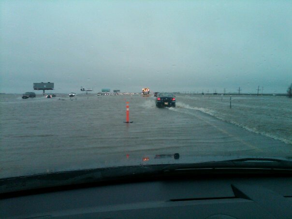
But outside of the cities, especially rural Cass county, water is worse than in 2009. Several roads have been built higher and thus blocking some water flow creating miles and miles and miles of lakes. Rush river, Sheyenne River and Maple River overland flooding is very severe. Most of the water is from Mapleton to Harwood west and north of Fargo. Here are some pictures showing I-29 north of Fargo....
One Question - WHY isn't Jim Cantore from the Weather Channel showing pictures like these??
Yeah, I know - they can barely find North Dakota on a map. and they're too terrified that the flight that gets them close enough won't have anything but propellers...
I am curious, does the city of Fargo stop people from building along the Red River now? I saw a news clip of a subdivision along the Red. The homes looked very new, and they showed people feverishly diking up their property with the Red rising behind them. They interviewed an older couple who said they are worried and scared but were greatful for the help ...they had just moved into their dream retirement home and now this flooding threatens their home. Don't these people know the history of the flooding in Fargo? I'm guessing the homes were built a few years ago...just curious. Though I have great sympathy for these people, but it seems like it is the same year after year and the news stories are the same ones we see year after year. Hopefully they can get some sort of **** system built in the near future. But I know it is expensive and funding is limited from the feds. Hope everyone makes it through this flood season safely.
For those interesting in the red river valley flood this year around Fargo. Fargo, Moorhead itself along the Red is OK The Red Crested 615 pm Saturday at 38.75 ft 4th highest on record.....
Hey Dan, I'm leaving tomorrow morning for Williston from Chicago. I normally take I-80 to I-29. Then take I-29 to Route 2 in Grand Forks, then west. Are there any road closures I should be aware of?
I am curious, does the city of Fargo stop people from building along the Red River now? I saw a news clip of a subdivision along the Red. The homes looked very new, and they showed people feverishly diking up their property with the Red rising behind them. They interviewed an older couple who said they are worried and scared but were greatful for the help ...they had just moved into their dream retirement home and now this flooding threatens their home. Don't these people know the history of the flooding in Fargo? I'm guessing the homes were built a few years ago...just curious. Though I have great sympathy for these people, but it seems like it is the same year after year and the news stories are the same ones we see year after year. Hopefully they can get some sort of **** system built in the near future. But I know it is expensive and funding is limited from the feds. Hope everyone makes it through this flood season safely.
Honestly I don't think many or any new subdivisions have been built along the river this decade, many properties have been bought out. That said maybe a few homes that flooded in 1997 were rebuilt. Most of the homes south of town along the river are very nice and in neighborhoods that are well maintained, so they might look nice and new but could have been in built the mid 1990s.
There are some new subdivisions in areas that are affected by overland flooding.
Hey Dan, I'm leaving tomorrow morning for Williston from Chicago. I normally take I-80 to I-29. Then take I-29 to Route 2 in Grand Forks, then west. Are there any road closures I should be aware of?
Last I checked, 31 miles of I-29 north of Fargo has been closed indefinitely due to overland flooding. You definitely should be prepared to take a different route - perhaps 94 west out of Fargo.
Hey Dan, I'm leaving tomorrow morning for Williston from Chicago. I normally take I-80 to I-29. Then take I-29 to Route 2 in Grand Forks, then west. Are there any road closures I should be aware of?
You should exit at I-94 at Fargo head west to Casselton....then followed marked detour ....Cass highway 18 to Highway 200A which then heads back to the interstate.
Honestly I don't think many or any new subdivisions have been built along the river this decade, many properties have been bought out. That said maybe a few homes that flooded in 1997 were rebuilt. Most of the homes south of town along the river are very nice and in neighborhoods that are well maintained, so they might look nice and new but could have been in built the mid 1990s.
There are some new subdivisions in areas that are affected by overland flooding.
I believe you are right... I dont know for sure....but I dont think any new homes were built after 97 flood.....so what was there was built before then. Before then, the idea that there would be so much flooding year after year was not thought of.
Well, maybe they needed to consult a few more old codgers... I remember when I was a kid (this would have been ca. 1963), being amazed at seeing watermarks just below second-floor windows in Grand Forks. Don't know where those buildings were offhand (it was a business district, tho) but obviously the river had been an inland sea long before today!!
And I remember water a foot deep through all of downtown Fargo in about '61 (not sure what year that big flood was) -- all the department stores had a huge Flood Sidewalk Sale afterward. You too can afford a nice wool or silk suit -- watermarked to the knees!
Please register to post and access all features of our very popular forum. It is free and quick. Over $68,000 in prizes has already been given out to active posters on our forum. Additional giveaways are planned.
Detailed information about all U.S. cities, counties, and zip codes on our site: City-data.com.

 Please register to participate in our discussions with 2 million other members - it's free and quick! Some forums can only be seen by registered members. After you create your account, you'll be able to customize options and access all our 15,000 new posts/day with fewer ads.