Please register to participate in our discussions with 2 million other members - it's free and quick! Some forums can only be seen by registered members. After you create your account, you'll be able to customize options and access all our 15,000 new posts/day with fewer ads.
Again, many of you are confusing Elevation with altitude.
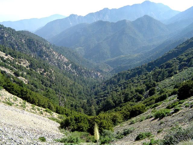
By the way, the San Gabriel Mountains, San Bernardino Mountains, and Santa Ana Mountains are tiny in square mileage. They're more or less like "islands" of mountains that spring forth above the surrounding flatter landscape, unlike other mountain ranges, such as the Appalachians or Rocky Mountains, which comprise a large area.
In this regard, the southern California mountain ranges are not unlike the Guadalupe Mountains of West Texas, or those isolated mountain ranges found in parts of Southern New Mexico, as well as parts of Arizona.
I'm not sure I follow what you are posting. The elevation of the San Gabriel mountains, in general, range 4000 to 10,000 feet above the San Gabriel valley where elevations range from 200 to 800 feet. The distance from Pomona at around 800 feet and Mt San Antonio [aka Mt Baldy] at over 10,000 feet is approximately 15 miles. The sharp incline from valley floor to mountain top is quite dramatic. This type of relief from coastline or valley to mountain height is common throughout Southern California. On the other side to mountain peaks like Mt San Jacinto at near 11,000 feet sits Palm Springs at 400 feet; a distance of less than 10 miles. How you can suggest that these mountains are like the Guadalupe Mountains in Texas at around 8000 feet and the surrounding lowland [Dell City or Salt Flat] between 2000 & 3000 feet within 20 miles?
The mountains of Southern California are part of the larger range of the 900 mile peninsular mountains [that include the San Bernardino mts] from Baja California into Southern California and rise close to 12,000 feet above desert regions that can be -200 feet below sea level over very short distances. In addition to the peninsular mountains is the transverse range [San Gabriel mts] that branch off the north\ south range of mountains from Canada to Mexico by angling east\ west into Los Angeles, Ventura and Santa Barbara counties. These mountains parallel the Tehachapi mountains [elevations up to 8000 feet] that connect to the Sierra Nevada mountains with elevations of up to 14,500 feet at Mt. Whitney. Death Valley which lies below Mt Whitney is the lowest spot in north America at -282 feet.
And of-course the Sierra Nevada mts along with the coastal ranges of Central and Northern California are part of the entire Pacific Coast Range from Alaska well into Mexico of over 2000 miles. A look at any map of mountain ranges in the U.S. easily shows the majesty of the West Coast mountains compared to the East Coast.
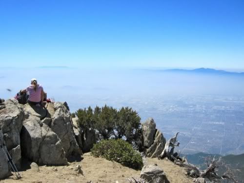
Mt. San Jacinto - Palm Springs below
From Palm Springs facing Mt Jacinto
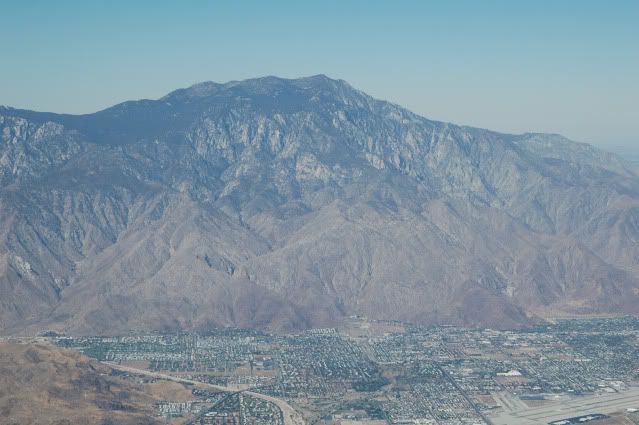
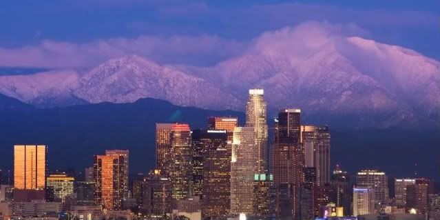
Los Angeles [elevation: 400ft] - Mt Wilson [elevation 4000ft]
This map is not very accurate. Maine, Connecticut and Massachusetts all have peaks that exceed 2,000 feet in elevation which I believe is the official height that designates a mountain.
I'm not sure I follow what you are posting. The elevation of the San Gabriel mountains, in general, range 4000 to 10,000 feet above the San Gabriel valley where elevations range from 200 to 800 feet. The distance from Pomona at around 800 feet and Mt San Antonio [aka Mt Baldy] at over 10,000 feet is approximately 15 miles. The sharp incline from valley floor to mountain top is quite dramatic. This type of relief from coastline or valley to mountain height is common throughout Southern California. On the other side to mountain peaks like Mt San Jacinto at near 11,000 feet sits Palm Springs at 400 feet; a distance of less than 10 miles. How you can suggest that these mountains are like the Guadalupe Mountains in Texas at around 8000 feet and the surrounding lowland [Dell City or Salt Flat] between 2000 & 3000 feet within 20 miles?
The mountains of Southern California are part of the larger range of the 900 mile peninsular mountains [that include the San Bernardino mts] from Baja California into Southern California and rise close to 12,000 feet above desert regions that can be -200 feet below sea level over very short distances. In addition to the peninsular mountains is the transverse range [San Gabriel mts] that branch off the north\ south range of mountains from Canada to Mexico by angling east\ west into Los Angeles, Ventura and Santa Barbara counties. These mountains parallel the Tehachapi mountains [elevations up to 8000 feet] that connect to the Sierra Nevada mountains with elevations of up to 14,500 feet at Mt. Whitney. Death Valley which lies below Mt Whitney is the lowest spot in north America at -282 feet.
And of-course the Sierra Nevada mts along with the coastal ranges of Central and Northern California are part of the entire Pacific Coast Range from Alaska well into Mexico of over 2000 miles. A look at any map of mountain ranges in the U.S. easily shows the majesty of the West Coast mountains compared to the East Coast.
Mt. San Jacinto - Palm Springs below
From Palm Springs facing Mt Jacinto
Los Angeles [elevation: 400ft] - Mt Wilson [elevation 4000ft]
I've driven in those mountains. They are not as dramatic as you're making them. I've camped out in the San Bernardino Mountains. I've driven the "Rim of the World Highway". While impressive, they don't strike you as being any taller than what can be found in western North Carolina. In fact, some areas within the western North Carolina mountains feel much more taller than anything in the San Gabriel, San Bernardino, or Santa Ana Mountains. While the greenery or smoothed nature may account for this, I'm being honest with my observations.
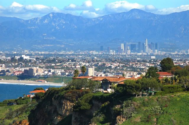
A telescopic lens was used to get that photo of the San Gabriel Mountains behind Los Angeles. The mountains, though only about twenty miles away, don't appear anything in the way of that altitude when looking from the ground. They simply don't. It's trick photography at best.
I haven't seen anyone confusing elevation with altitude. The California ranges you mention have peaks substantially higher than any found in the Appalachians. No contest. These areas are also not "tiny" in square mileage either, and I'm not sure what that has to do with anything since they're still higher than the Appalachians.
The Appalachians extend from Georgia to Maine.
The ranges of southern California might extend forty miles, broken up, then another forty miles. They don't extend into another states, such as Arizona or Nevada. Compared to the Appalachians or the Rockies, they ARE tiny, square-mileage wise.
I'm not sure of the exact method for determining "true elevation" of peaks--I know some of the peaks in the East have technically high elevation gains from base to summit--it's just hard to tell by looking at them. But I do know that I've done climbs where the elevation gain alone from trail head to summit on peaks like Mt. Adams in the Cascades and Grand Teton in Wyoming was close to 7000 feet.
No, the Transverse Ranges--of which the San Gabriel and San Bernardino's are a part of--are an extension of the Coast Ranges stretching basically from Alaska to Mexico with few gaps except for spots like San Francisco Bay or the Columbia River. They simply go east-west instead of north to south because of a bend in the San Andreas Fault, the Tehachapis connect the Transverse Mountains to the Southern Sierras and the Peninsular Mountains flow into Baja. It's really not that small an area considering they stretch from the coast west of Santa Barbara east to Palm Springs and the Coachella Valley.
I'd do love to do all three if I was independently wealthy...
I've gone the whole length of the John Muir Trail though and I've hiked through or climbed through most of the prominent areas on the PCT trail. I've hiked through a good portion of southern part of the Appalachian Trail in North Carolina on my visits to Asheville. Beautiful country...
I'm in southern California every year, and the area from the San Gabriel Mountains over to Tehachapi is miles of mostly flat high desert, almost until you hit Tehachapi. The Tehachapi Mountains does connect to the western end of the San Gabriel Mountains, but this mountain range is no more than about ten miles across. The Tehachapis run northeast-southwest, while the Sierra Nevada are northwest-southeast. The San Gabriels and San Bernardinos run east west. Unless you're claiming that mountains that extend in opposite directions are part of the same mountain range, then you don't have much of a point. As stated, only a tiny small link, relative to the mass of all the mountain ranges, can be found. You could make an argument for the San Bernardino and the San Gabriels being connected, as only the Cajon pass separates the two.
I'm in southern California every year, and the area from the San Gabriel Mountains over to Tehachapi is miles of mostly flat high desert, almost until you hit Tehachapi. The Tehachapi Mountains does connect to the western end of the San Gabriel Mountains, but this mountain range is no more than about ten miles across. The Tehachapis run northeast-southwest, while the Sierra Nevada are northwest-southeast. The San Gabriels and San Bernardinos run east west. Unless you're claiming that mountains that extend in opposite directions are part of the same mountain range, then you don't have much of a point. As stated, only a tiny small link, relative to the mass of all the mountain ranges, can be found. You could make an argument for the San Bernardino and the San Gabriels being connected, as only the Cajon pass separates the two.
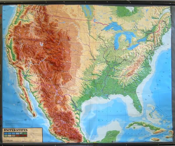
You are so incorrect and make me wonder what your agenda is. Take a look at relief map of the United States. As stated earlier the mountains in Southern California are part of the entire series of ranges from central Mexico into Canada and up into Alaska; much longer, higher and much more rugged than anything on the East Coast.
If you have been in Southern California as you claim than you are blind if you want to characterize the land as flat. From downtown Los Angeles north one must cross the Santa Monica mountains [within the city limits] from 2000 to 3000 feet above the LA basin [sealevel to 400 ft] and San Fernando Valley [elevation from 200 to 700 feet]. Within 10 miles north on Interstate 5 one reaches the Santa Susana mts. [elevation 2000-3000ft] before dropping into the Santa Clarita valley [elevation sealevel to 1200 ft] which is, at the most 5 miles across. Then one ascends the Tehachapi Mts, an east\west mountain range that separates Los Angeles county from the Central Valley. The distance from Santa Clarita to the Grapevine is 40 miles of mountains that rise up to 8000 feet. The Tejon Pass is over 4000 feet and occasionally the freeway is closed during winter storms due to snowfall.
I'm not sure why you are misrepresenting the mountains of California Maybe you can produce photos of East Coast mountains so we can compare.
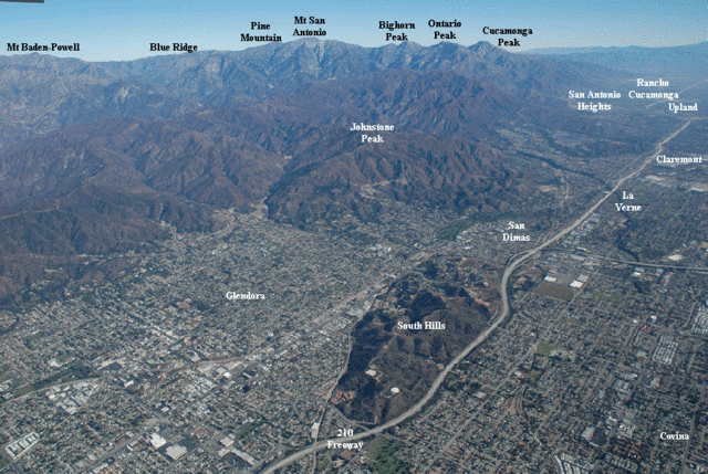
Mountains & elevation map of the U.S.
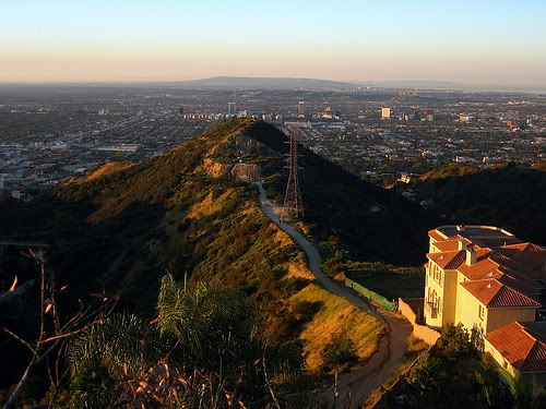
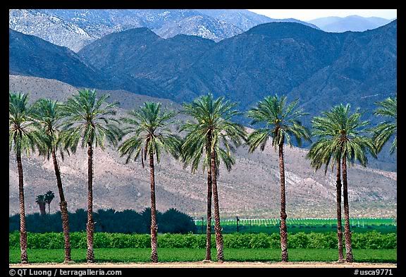
San Gabriel Mts. [elevation 4000 to 10,000 ft]
San Gabriel mts looking from Rancho Palos Verdes
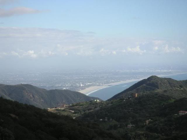
Santa Monica Mts [elevation 2000-3000 ft] looking down on the beach and Santa Monica
Santa Monica Mt within Los Angeles city, looking down onto the San Fernando Valley
San Gabriel Mts. above San Gabriel valley
You are so incorrect and make me wonder what your agenda is. Take a look at relief map of the United States. As stated earlier the mountains in Southern California are part of the entire series of ranges from central Mexico into Canada and up into Alaska; much longer, higher and much more rugged than anything on the East Coast.
I have no agenda.
I realize that there are many DISJOINTED, NON-CONNECTED mountain ranges all over the western U.S. If you want to claim them as being part of the same mountain chain, then go right ahead. It doesn't take away from the fact that these mountains aren't one continous mass of mountains, much like the Appalachian Chain.
Quote:
If you have been in Southern California as you claim than you are blind if you want to characterize the land as flat.
It is north of the San Gabriel Mountains. In the high desert, it's about as flat as a pancake, along highway 18 and 138 connecting Victorville to Palmdale. You do start to hit hills around Palmdale and Lancaster, and you hit mountains right before you get to Tehachapi.
If you're coming from the San Fernando Valley, sure, you're travel through the pass on up to Santa Clarita, and there are mountains there. It depends on what direction you are coming from. I was pointing out that if one is coming from the east, north of the San Gabriel Mountains, it is flat up until you get close to the Tehachapi Mountains. That's a fact.
Quote:
From downtown Los Angeles north one must cross the Santa Monica mountains [within the city limits] from 2000 to 3000 feet above the LA basin [sealevel to 400 ft] and San Fernando Valley [elevation from 200 to 700 feet]. Within 10 miles north on Interstate 5 one reaches the Santa Susana mts. [elevation 2000-3000ft] before dropping into the Santa Clarita valley [elevation sealevel to 1200 ft] which is, at the most 5 miles across. Then one ascends the Tehachapi Mts, an east\west mountain range that separates Los Angeles county from the Central Valley. The distance from Santa Clarita to the Grapevine is 40 miles of mountains that rise up to 8000 feet. The Tejon Pass is over 4000 feet and occasionally the freeway is closed during winter storms due to snowfall.
I just pointed out that it depends on where you're coming from.
Quote:
I'm not sure why you are misrepresenting the mountains of California Maybe you can produce photos of East Coast mountains so we can compare.
I know my Geography, better than most people. I speak nothing but facts with regard to the direction of which mountain ranges exist, or "flow".
I realize that elevations of the western mountains are higher. I've never claimed that they are not. my argument has been that they aren't as tall, from base to summit, that many of you make them out to be. For example, the San Bernardino Mountains are actually shorter from base to summit than the Appalachians in many areas, if one is driving from the high desert up to Big Bear. On the other hand, if coming from the south, the increase in elevation is greater. As such, this is different than in the Appalachians, where the differences from base to summit is roughly equal on all sides.
Please register to post and access all features of our very popular forum. It is free and quick. Over $68,000 in prizes has already been given out to active posters on our forum. Additional giveaways are planned.
Detailed information about all U.S. cities, counties, and zip codes on our site: City-data.com.

 Please register to participate in our discussions with 2 million other members - it's free and quick! Some forums can only be seen by registered members. After you create your account, you'll be able to customize options and access all our 15,000 new posts/day with fewer ads.


 Maybe you can produce photos of East Coast mountains so we can compare.