Please register to participate in our discussions with 2 million other members - it's free and quick! Some forums can only be seen by registered members. After you create your account, you'll be able to customize options and access all our 15,000 new posts/day with fewer ads.
I find this to be a pretty accurate map, and you definitely nailed Missouri. Here in St. Louis, we always say that south of us is "the South", and north of us is the Midwest. We're just about on the dividing line.
Id agree with the map also. Southern IL is definitely very southern in its feel/lifestyle/accents.
It's a pretty expensive application, and you need data sets to run it effectively. For instance, I used a county dataset: the boundaries you see here are delineated along county lines.
I'm a GIS professional as well (I have ArcInfo open as I type this), and I think that's the most accurate regional map I've ever seen, at least of the areas I'm familiar with. I used to do land use analysis for the federal government, so I have some really random (almost trivial) knowledge of agriculture & geography in the eastern US.
I'm guessing that you analyzed some data (rather than just picking counties off the top of your head) in order to get that map. I'm impressed with how you separated the coast of Florida from inland, and how you separated the appalachians from the flatter regions of the south. I would've pushed the Appalachians into Georgia a little bit, though. Was that based on statistical agricultural use, or did you just "draw" the boundaries manually?
I would've pushed the Appalachians into Georgia a little bit, though.
The Appalachian Regional Commission (http://www.arc.gov/index.do - broken link) has a very good map of the Appalachian region. And it lists the exact counties. Liz
I'm a GIS professional as well (I have ArcInfo open as I type this), and I think that's the most accurate regional map I've ever seen, at least of the areas I'm familiar with. I used to do land use analysis for the federal government, so I have some really random (almost trivial) knowledge of agriculture & geography in the eastern US.
I'm guessing that you analyzed some data (rather than just picking counties off the top of your head) in order to get that map. I'm impressed with how you separated the coast of Florida from inland, and how you separated the appalachians from the flatter regions of the south. I would've pushed the Appalachians into Georgia a little bit, though. Was that based on statistical agricultural use, or did you just "draw" the boundaries manually?
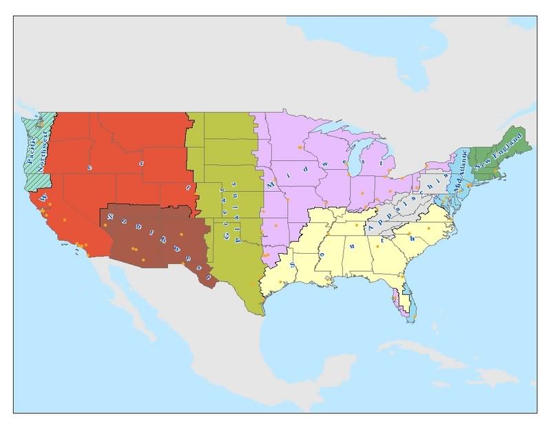
I drew a great deal of these boundaries based on personal travel experience. In the case of Appalachia, I thought it would be valid to draw the boundaries based on the terrain of the Appalachians, so I did a 'select by location' to extract the county data from that set. I also did a 'dissolve' command to alleviate all county boundary lines, and made a separate shapefile from the original county data set. Some of it was more difficult though, based on lack of knowledge, for instance, I've never been to Utah or North Dakota before. However, I know that average waterfall for a steppe climate is less than 20 inches annual, and that's essentially where I delinieated the Midwest vs Great Plains boundary, based on average precip. Then there's the matter of where the Great Plains transition into the foothills of the Rocky Mountain Range. Since this is less of a continuous land pattern change and is more abrupt, I felt more comfortable with the Great Plains into West/Southwest regions, which are dominated by mountains.
I made a map for another thread I thought I'd share for this board. I made the South a region, as I did Appalachia, because I think the mining extraction element as primary economy belongs in Appalachia. That's how I distinguished it from the South, which is more agricultural. I also put in all the other regions. To me, you can't just give an entire state and classify it as a region. For instance, New York to me, is four different regions (little New England, lot of Mid Atlantic, Appalachia on the Southern Tier, and a little Midwest flavor around Buffalo and Rochester).
Anyway, here is my map, and my perception of the South, as well as other regions:
I personally don't think you included enough of Kentucky in the South but that's just me.
I personally don't think you included enough of Kentucky in the South but that's just me.
I've been to Louisville before, and I consider it right on the fence, when it comes to Midwest vs South. I see you live there. I had a hard time but finally decided it was Midwest. What do you think? Like I said, I was just a visitor!
I've been to Louisville before, and I consider it right on the fence, when it comes to Midwest vs South. I see you live there. I had a hard time but finally decided it was Midwest. What do you think? Like I said, I was just a visitor!
I think it is fairly well divided. The East end/downtown and such is more Midwest and the Southend/Southwest part of the county is more Southern. But again, that's just me.
This may have been beaten to death other times, but I don't feel like digging for an answer...
how come a lot of people down south like to exclude Florida as a southern state? Geographically, you can't get more south. It doesn't make any sense to me.
i like the map, overall. except tampa is NOT part of the midwest. i would know, cos i'm from there. love that the east coast of florida is part of the mid-atlantic though, definitely true! not to say the west coast of florida (like tampa) isn't influenced by the midwest, but tampa & the areas east and north of it are definitely southern. when you get to st. pete, clearwater, sarasota, bradenton, etc., that's when the transplants really take over more.
i personally think the midwest could do without that section of texas, seeing as texas is always either the south, the great plains or the southwest. midwest doesn't generally stretch that far south. that'd put dallas & ft. worth in the same region as chicago, minneapolis, toledo, etc.
also, the line of the south in kentucky should be raised, but not for kentucky's sake, but only to cross over into southern indiana & southern ohio. a good amount of these areas south of I-70 definitely have a noticeable southern influence, which is odd, considering they are states that are on the great lakes. i think the line for missouri & arkansas should be stretched a bit more westward, not covering the states completely, but just a bit more so, especially the entirety of the ozarks.
trying to match it up exactly by county, so does syracuse fit in the mid-atlantic or the midwest? looks like it's either the first or last county in both, but i can't figure it out. funny that you put rochester, buffalo, erie, & pittsburgh in the midwest though - that's what everyone says, regardless if they're in the same states as where NYC & philly are!
the only other odd thing is that california (and all of it's cities) are lumped in with the west - where no other dots are present, at all. maybe you could switch that and create a 'west coast' region too, as i don't think san diego or los angeles has much in common with spokane, boise, salt lake city, etc.
that's just MY perspective though. if i could make a map like that, i definitely would. but yours is awesome, just my opinions!
how come a lot of people down south like to exclude Florida as a southern state? Geographically, you can't get more south. It doesn't make any sense to me.
Geographically, yes, it's a state in the south. But it's not a southern state. TOO many people there are northern transplants. Liz
Please register to post and access all features of our very popular forum. It is free and quick. Over $68,000 in prizes has already been given out to active posters on our forum. Additional giveaways are planned.
Detailed information about all U.S. cities, counties, and zip codes on our site: City-data.com.

 Please register to participate in our discussions with 2 million other members - it's free and quick! Some forums can only be seen by registered members. After you create your account, you'll be able to customize options and access all our 15,000 new posts/day with fewer ads.