Please register to participate in our discussions with 2 million other members - it's free and quick! Some forums can only be seen by registered members. After you create your account, you'll be able to customize options and access all our 15,000 new posts/day with fewer ads.
I think New York, along with Texas and to a lesser degree, Florida, have the most diverse regional areas. It's a very difficult state to pigeonhole in terms of where you live and identity. On my map, New York is 4 distinct regions.
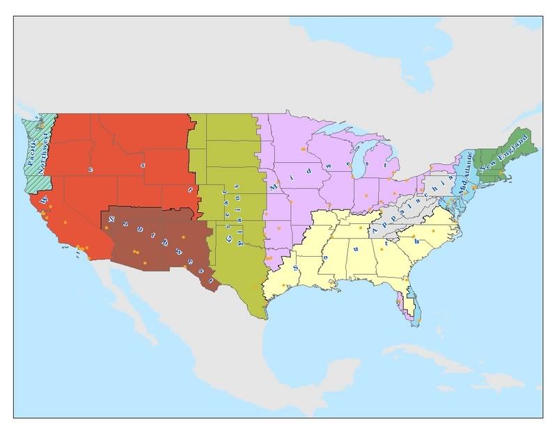
I really disagree with the regional definitions of this map. Your extension of the Midwest all the way down into areas of Oklahoma, Arkansas, and Texas is a little ridiculous. These areas have much more in common with the south overall. The southwest zone can be extended further to the north and west as well. The Great Plains boundary can be extended further to the east, and the Mid Atlantic zone should be shifited south. Areas northeast of Lake Ontario in upstate New York are usually referred to as the north country.
I agree more with Rochester and west in NY being a transition area, along with Pittsburgh and the extreme western counties of Pennsylvania. I am from one of those counties, and have lived in the midwest and west since I was 22. Believe me, the midwest does not consider PA or NY "midwest", period. To be part of the area, you have to be accepted in that area, I think.
A geography book I read in college, which dated from the 1950s, had a map where the "Great Lakes Region" started mid-way between Syracuse and Utica. Syracuse was in the Great Lakes Region and Utica was in the Northeast Region.
IMO, Syracuse IS the transition area. West of Syracuse feels more Midwestern. East of Syracuse feels more Northeastern. It's a toss up which region Onondaga County/Syracuse should fall in.
Hamilton County and Essex County feel very Canadian to me because of the landscape and climate. Saranac Lake is one of the coldest areas in the eastern US in the Adirondack Mountains. Their is a reason why this area is called the north country. It is located within the zone 2 to zone 3 hardiness zone.
The southwest zone can be extended further to the north and west as well.
I think anywhere in California south of San Francisco, basically central and southern California could be southwestern, but southern California especially should be considered southwest.
Drive 1-2 hours east from anywhere between Santa Barbara and San Diego and you're likely to find piping hot desert, even though the California state border is another 3-6 hours further east.
People from Buffalo, Rochester, Cleveland and Milwaukee call me "Taaaam" instead of "Tom". I'd say the accent of upstate NY is more similar to that of the Midwest than that of the North East.
That's pretty much the accent here in Scranton/Wilkes-Barre as well. A world like "water" is pronounced "wahter" instead of "wooder" as in Philly, NJ, or NY. We're definitely eastern here as far as geography goes, we're 2 hours north of Philly and 2 hours west of NYC. But Scranton has more in common with Pittsburgh as far as culture, values, and industrial past than it does with New York or Philly.
In the two Midwestern states I've lived in, IA and MN, lots of people think of Detroit and Cleveland as Eastern cities. To them, the Midwest is Chicago, Indianapolis, Twin Cities, Milwaukee, St Louis, KC, Omaha etc.. So maybe we should instead be asking, Is Eastern Ohio and Southeastern Michigan Eastern, Midwestern, or a Separate Region? It's all about perspective!
I think New York, along with Texas and to a lesser degree, Florida, have the most diverse regional areas. It's a very difficult state to pigeonhole in terms of where you live and identity. On my map, New York is 4 distinct regions.
The South again doesn't extend that far north in Missouri. I know this better than anyone on here. It does not begin just below St. Louis. Much of that region you high-lighted is the Ozark region. Years, years ago, like before the Civil War, I would be pre-empted to agree with that definition. But much of the area you highlighted as the South in Missouri is a transitional area...both southern and midwestern. Southeast Missouri around Cape Girardeau is where where Missouri becomes truly southern, mainly when Illinois no longer is on Missouri's eastern border. This map is missing important transition areas. Also, Texas and most of Oklahoma are not Midwestern whatsoever. Basically, the northern boundaries of the south in Missouri are further south than this map claims, because you go from Midwest to pure south instantly on this map...far, far, far from the truth. and there is nothing Midwest about Texas or most of Oklahoma except maybe in the northeastern areas. THis map is extremely lacking in transitional areas. But that's just my opinion, and I'm not in the mood to have an argument about this when we are focusing on Western New York here. Also, Southern Illinois I've found is not truly Southern until below Carbondale, mainly around the Shawnee National Forest. The Ohio River is basically the northern boundary of the true south, and the latitude at which the river flows into the mississippi is basically the one across missouri for the true south. Trust me, when you cross into Paducah from Carbondale in Southern Illinois, there is a BIG change. THe same thing goes with Perryville, MO to Sikeston, Missouri. A big change in culture and speech patterns and landscape. Also, this map proposes including Louisville in the Midwest. Not true at all. Louisville is a true Southern city, as is Lexington. It is quite amazing how different Southern Indiana right across the river is from Louisville. The Ohio River and Highway 60 are the true boundaries of the South. However, I agree with the rest of the map.
I think New York, along with Texas and to a lesser degree, Florida, have the most diverse regional areas. It's a very difficult state to pigeonhole in terms of where you live and identity. On my map, New York is 4 distinct regions.
The South again doesn't extend that far north in Missouri. I know this better than anyone on here. It does not begin just below St. Louis. Much of that region you high-lighted is the Ozark region. Years, years ago, like before the Civil War, I would be pre-empted to agree with that definition. But much of the area you highlighted as the South in Missouri is a transitional area...both southern and midwestern. Southeast Missouri around Cape Girardeau is where where Missouri becomes truly southern, mainly when Illinois no longer is on Missouri's eastern border. This map is missing important transition areas. Also, Texas and most of Oklahoma are not Midwestern whatsoever...Oklahoma and Arkansas being half-midwestern nearly is ludicrous. Arkansas is 100% Southern...Oklahoma is a half-Southern, half-Great Plains state. And the northern boundaries of the south in Missouri are further south than this map claims, because you go from Midwest to pure south instantly on this map...far, far, far from the truth. and there is nothing Midwest about Texas or most of Oklahoma except maybe in the northeastern areas. THis map is extremely lacking in transitional areas. But that's just my opinion, and I'm not in the mood to have an argument about this when we are focusing on Western New York here. Southern Illinois, Southern Indiana, Southern Ohio below Cincinnati, and Southern Missouri are the transition areas between the Midwest and South. Not quite Midwestern, but not quite Southern either.
"Officially"? By whose definition? Maybe the census bureau's, but a lot of people consider Ohio the east, esp. eastern Ohio, which has its ties to Pittsburgh. A lot of people consider Michigan the east, as well. It also depends on where you are. In California, Illinois is considered "back east". In Colorado, Ohio and Michigan are considered "the east" by many people.
By whose definition, you say? Oh, the Census Bureau, the Northwest Ordinance, the people that live there...the Corn Belt starts there as well as the Grain Belt, the Midwestern speech patterns generally begin there...if you feel the need to take everything literally, that's fine...but there is no way to claim Ohio is a Northeastern state. Pittsburgh has a lot of Midwestern flavor to it as well, it has much more in common with Cleveland and Columbus than it does with Philadelphia.
Please register to post and access all features of our very popular forum. It is free and quick. Over $68,000 in prizes has already been given out to active posters on our forum. Additional giveaways are planned.
Detailed information about all U.S. cities, counties, and zip codes on our site: City-data.com.

 Please register to participate in our discussions with 2 million other members - it's free and quick! Some forums can only be seen by registered members. After you create your account, you'll be able to customize options and access all our 15,000 new posts/day with fewer ads.