Please register to participate in our discussions with 2 million other members - it's free and quick! Some forums can only be seen by registered members. After you create your account, you'll be able to customize options and access all our 15,000 new posts/day with fewer ads.
Location: The Greatest city on Earth: City of Atlanta Proper
8,468 posts, read 14,905,959 times
Reputation: 7263
Advertisements
Quote:
Originally Posted by davidals
The real test will be in the future - as Sunbelt cities lose the ability to annex, how will their growth curve look in comparison with older Northeastern or Great Lakes cities? There are Sunbelt cities with very diverse economies that are deeply rooted, and there are Sunbelt cities that aren't - so it stands to reason that there will be Sunbelt cities that will sustain themselves as Boston, the Twin Cities or Chicago have done, and there will be other Sunbelt cities that that won't, in the fashion of Detroit or Flint. A comparative look at Memphis, Birmingham, Mobile and New Orleans (NOLA's 50-year trend, not just the post-Katrina aftermath), versus Atlanta, Houston, Raleigh, Charlotte or Austin would reveal some stark differences in economic structure, educational environment and a host of other factors, and those are the factors that will (or won't) drive growth. Atlanta has run out of anything to annex, and Charlotte will be in the same boat within 10 years, so a look at MSA or CSA populations will really reveal the truth in how it all plays out.
It will be interesting to see how sustainable these massive cities will be in the future. Most I think will be ok, but the law of averages says that it is likely one will have trouble keeping up with providing efficient services to it's residents over the long run. There is also the matter of governing an area that large with a growing population. Political fractures will appear and there will be "localization".
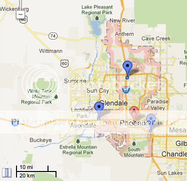
Hey, while we talking about city sizes and stuff, I decided to cobble together (thanks to a new feature in Google Maps) maps of central city limits in relation to the surrounding metro area. While I won't take the time to do all of the cities on the OP I've broken it out to the 10 largest city propers by population, central cities of the 10 largest Metropolitan areas, and some extra cities that don't make either of those lists but are interesting none the less. I initially wanted to do the maps at a "height" of 5 miles, but some of the cities didn't fit so I had to zoom out to 10 miles. The central city is highlighted in pink.
10 Largest Cities by Population
1. City of New York (Manhattan, Brooklyn, Queens, The Bronx, Staten Island), 302.6 square miles (Metro rank #1)
2. City of Los Angeles, 468.7 square miles (Metro rank #2)
3. City of Chicago, 227.6 square miles (Metro rank #3)
4. City of Houston, 634 square miles (Metro rank #5)
5. City of Philadelphia, 134.1 square miles (Metro rank #6)
6. City of Phoenix, 516.7 square miles (Metro rank #14)
7. City of San Antonio, 460.9 square miles (Metro rank #24)
8. City of San Diego, 325.2 square miles (Metro rank #17)
9. City of Dallas, 340.5 square miles (Metro rank #4)
10. City of San Jose, 176.5 square miles (Metro rank #31, #6 when combined with San Francisco and Oklahoma)
Central city sizes for remaining top 10 Metro Areas, not listed above
City of Miami, 36 square miles
City of San Francisco, 49 square miles
City of Boston, 48.3 square miles
Washington, District of Columbia, 61 square miles
City of Atlanta, 131 square miles
Other cities with large populations and/or square mileage
City of Jacksonville, 747 square miles
City of Charlotte, 297.7 square miles
Oklahoma City, 606 square miles
City and Borough of Anchorage, 1697 square miles (YOWSA! )
For most Sunbelt cities, annexation was the only way to grow since many of their current cities' limits were woods/fields/marsh etc. back in 1950.
I don't know if this is the case but to even suggest that annexation is the only reason that these places have grown is ignoring the truth. Perhaps one should compare county populations instead? County lines don't change and arguably provides the most comparable data.
For my two counties in the Sunbelt, it looks like this:
Wake County (Raleigh)
1950: 136,450
2011: 929,780 (+~580%)
Yep...that's real significant growth over the last 60+ years despite municipal annexation. I suspect it's typical for other Sunbelt core counties as well.
While that's true, Miami-Dade is a pretty poor example as it didn't annex nearly as much as some of the other cities on this list.
Yes, but it does depend on where in the Sunbelt we're talking about. There are entire states where this doesn't apply, not much at least. Looking at the numbers just between VA, NC, SC and GA would reveal some very different patterns, from state to state, and the percentages would be very different. Someone else mentioned Atlanta - involuntary annexations in Georgia came to a dead stop after about 1952; since then, Columbus, Augusta, Athens and 3 or 4 rural counties have done consolidations to get around this. In Atlanta it's not a possibility as the city is now surrounded by (recently) incorporated municipalities.
In Virginia, the last big annexation was......
....
truth in how it all plays out.
That's all very well written, and I can't dispute any of it because I would have no idea of particular states laws regarding annexation, though I think it's jist has pretty much been covered already.
All I'm doing is reiterating is what this thread's point is. I'm not saying, and neither is anyone else, that the only reason Sunbelt cities grew is because of annexation. Nor are we saying that every Sunbelt city is the same and have all annexed masses of land. All that's being said is that annexation should be taken into account when making great sweeping statements about how much cities in the South and West have grown.
Some have grown largely through migration and births-deaths, and that's great, but others have probably barely grown within their 1950 city limits.
Last edited by BruceTenmile; 07-18-2012 at 03:00 AM..
Thanx very much man. This is pretty damn cool. Obviously this doesn't tell us how much population was gained between censuses due to annexation rather than migration or births-deaths. It's still incredibly interesting, so thanx a lot. Table 1 is especially brilliant.
The annexation issue is not black and white. In some cases, annexation "artificially" increases population of a city when that annexation was already developed and populated. Fayetteville, NC had one of those types of annexations in the last decade; it did not reflect the real growth rate of the area. In many other fast growing Sunbelt cities, land has been annexed in alignment with new development. In the case of many cities, virgin land is grabbed way in advance of development: sending the density metric spiraling downward, only to tick up again as the land is developed and populated.
While that's true, Miami-Dade is a pretty poor example as it didn't annex nearly as much as some of the other cities on this list.
MiamiDade is a county.
Miami City grows more slowly since it's less than 36 square miles and not expanding. Still it added 1000 ppl/sq mile in the last decade.
It will be interesting to see how sustainable these massive cities will be in the future. Most I think will be ok, but the law of averages says that it is likely one will have trouble keeping up with providing efficient services to it's residents over the long run. There is also the matter of governing an area that large with a growing population. Political fractures will appear and there will be "localization".
Hey, while we talking about city sizes and stuff, I decided to cobble together (thanks to a new feature in Google Maps) maps of central city limits in relation to the surrounding metro area. While I won't take the time to do all of the cities on the OP I've broken it out to the 10 largest city propers by population, central cities of the 10 largest Metropolitan areas, and some extra cities that don't make either of those lists but are interesting none the less. I initially wanted to do the maps at a "height" of 5 miles, but some of the cities didn't fit so I had to zoom out to 10 miles. The central city is highlighted in pink.
10 Largest Cities by Population
1. City of New York (Manhattan, Brooklyn, Queens, The Bronx, Staten Island), 302.6 square miles (Metro rank #1)
2. City of Los Angeles, 468.7 square miles (Metro rank #2)
3. City of Chicago, 227.6 square miles (Metro rank #3)
4. City of Houston, 634 square miles (Metro rank #5)
5. City of Philadelphia, 134.1 square miles (Metro rank #6)
6. City of Phoenix, 516.7 square miles (Metro rank #14)
7. City of San Antonio, 460.9 square miles (Metro rank #24)
8. City of San Diego, 325.2 square miles (Metro rank #17)
9. City of Dallas, 340.5 square miles (Metro rank #4)
10. City of San Jose, 176.5 square miles (Metro rank #31, #6 when combined with San Francisco and Oklahoma)
Central city sizes for remaining top 10 Metro Areas, not listed above
City of Miami, 36 square miles
City of San Francisco, 49 square miles
City of Boston, 48.3 square miles
Washington, District of Columbia, 61 square miles
City of Atlanta, 131 square miles
Other cities with large populations and/or square mileage
City of Jacksonville, 747 square miles
City of Charlotte, 297.7 square miles
Oklahoma City, 606 square miles
City and Borough of Anchorage, 1697 square miles (YOWSA! )
The annexation issue is not black and white. In some cases, annexation "artificially" increases population of a city when that annexation was already developed and populated. Fayetteville, NC had one of those types of annexations in the last decade; it did not reflect the real growth rate of the area. In many other fast growing Sunbelt cities, land has been annexed in alignment with new development. In the case of many cities, virgin land is grabbed way in advance of development: sending the density metric spiraling downward, only to tick up again as the land is developed and populated.
I don't know if the red highlighting of my comment was because you think what I said was contrary to your reply or simply to underline and expand on the point, but the reality is I entirely agree with you and find what you say interesting. I've never said it was a black and white issue, all I've been saying is that the existence of annexation needs to be remembered.
It will be interesting to see how sustainable these massive cities will be in the future. Most I think will be ok, but the law of averages says that it is likely one will have trouble keeping up with providing efficient services to it's residents over the long run. There is also the matter of governing an area that large with a growing population. Political fractures will appear and there will be "localization".
All very interesting, and the localization issue is another one we'll be seeing more of. There have been efforts in NYC and LA pushing for the secession of Staten Island and the San Fernando Valley respectively, and the same kind of sentiment is beginning to surface is smaller (but still major) cities as well; there's a push for the area of Charlotte south of the 485 loop to secede, and it's unlikely to gain any traction in the NC legislature, but we'll be seeing more of this in the large-land-area cities as time goes by.
Anchorage is interesting - it's a city-county (or more accurately a city-borough) consolidation (so are Juneau, Sitka and Yakutat, AK), but the actual amount of buildable land - the urban area is a VERY small fragment of that area. Thus, the city population density through the entire city limits area is the lowest of any US city in the top 100, BUT the density of the actual built, urban area is comparable to many cities in the lower 48. Why? Anchorage covers a lot of territory, but is pretty much built out in actual buildable land, so within that smaller, built urban area densities are heading upwards (through a lot of aggressive infill, mainly in the form of condo developments) in a way that a simple look at the overall city density would not reveal. The same is true in Juneau, which is shoe-horned into a very, very small shelf of buildable land along the channel, Douglas, and the Mendenhall valley area, while more than 90% of the city's land area is wilderness.
This also applies to a few large-area cities in the lower 48 - Suffolk and Chesapeake VA, New Orleans LA, Butte MT, and Jacksonville FL all have wilderness areas, unbuildable swamp, forest preserves, or National Wildlife Refuges within their city limits (in Suffolk VA, it's more than half of the area within the city limits), so again a look at the density of the actual developed "urban" area paints a far more accurate picture of the city's density than a look at the official census "city limits"-based number.
What about Toronto and Montreal? Their populations were around 600,000-700,000 back in the late 70s. Now they're 1.8-2.5 million.
Something similar to consolidations in the US - they're called amalgamation in Canada, and in several other countries they are called "special cities" or "municipalities." In Canada, counties have largely become defunct, and there was a wave of these amalgamations in the 1980s and 90s - Toronto, Ottawa, Montreal all did this - consolidating the city proper, the surrounding suburban municipalities, and the defunct county into one new, reconstituted single-government municipality; in these cases there's a semi-federal nature to the consolidation, which is VERY similar to the structure of the governments in NYC and Miami-Dade.
Some smaller Canadian cities did the same - LaTuque, Quebec and Ft. McMurray, Alberta are technically the largest cities, by land area, in North America, again through amalgamation (consolidation). Ft. McMurray's "city limits" area is about the size of South Carolina.
All of Mexico, and PR China are divided into municipalities, which are counted as the official "city" population, and the "city" is divided into "counties" which function like the boroughs of NYC as semi-autonomous constituents within the "city", which may cover more than 1000 square miles. This is essentially the reverse of the US city vs. county structure. So a city like Chengdu in China covers more than 1000 square miles, and has a population into the millions, even though 3/4 of the "city" is rural, at least half of what's left is "suburban", and the last remainder is the urban core, which has a significantly smaller population.
If we were to do something like this in the US, to offer a random example, one would (1) extend the "city limits" of Atlanta outward to cover the entire Atlanta CSA, (2) make those boundaries permanent, and then (3) make each county and incorporated municipality within those counties (which would become "county equivalents") a component in a federal structure, from which the actual "city" government would be drawn.
Please register to post and access all features of our very popular forum. It is free and quick. Over $68,000 in prizes has already been given out to active posters on our forum. Additional giveaways are planned.
Detailed information about all U.S. cities, counties, and zip codes on our site: City-data.com.

 Please register to participate in our discussions with 2 million other members - it's free and quick! Some forums can only be seen by registered members. After you create your account, you'll be able to customize options and access all our 15,000 new posts/day with fewer ads.


 )
)


