Virginia is the Birthplace of Southern Culture ! (vs., moving)
Please register to participate in our discussions with 2 million other members - it's free and quick! Some forums can only be seen by registered members. After you create your account, you'll be able to customize options and access all our 15,000 new posts/day with fewer ads.
Notice that I said a lot of those pictures. Not all of them. Does New York have swamps? Yes. Cypress swamps? Probably not. The rest of the pictures could easily be in the northeast.
If those pictures are Virginia, then they are in the northeast in my opinion.
Cotton fields in the northeast? Shirley plantation in the northeast? Cypress swamps in the northeast? No, none of these can be found in the northeast, especially not cypress swamps and cotton fields, they are symbols of the south and they are found in virginia.
I just said that I was not talking about all the pictures. But let me ask you a question. Is Texas the South to you?
ok I have pictures here from different states...I want you to guess which ones are from the south and which ones are from the north and see if they fit your view of the south
Location: Uniquely Individual Villages of the Megalopolis
646 posts, read 812,936 times
Reputation: 36
Quote:
Originally Posted by mpope409
The North.
Thought you might be interested how the whole thing looks from space
Northeastern Seaboard of the US includes Virginia's fairly large Eastern metro areas and the pull of the NE Corridor into the so called Megalopolis. The darker areas still linked but and the orientation is clearly shown, they're simply less nightlight density at this resolution.
[SIZE=+1]STS-98 Shuttle Mission Imagery[/SIZE] high res (2.6 M) low res (111 K) STS098-382-0014 (7-20 February 2001) City Lights of the Northeastern Seaboard of the U.S. were captured with a 35mm camera by one of the STS-98 astronauts aboard the Space Shuttle Atlantis. The nighttime scene shows the bright lights of several major cities that span a distance from Connecticut (left middle) to states south of Virginia (right middle). Lights from both very large urban areas as well as smaller towns and cities are visible. The largest cluster of brightness emanates from the greater New York metropolitan area (left center) and then a series of bright spots progress southwesterly to include Philadelphia (PA), Baltimore (MD), Washington (D.C.), Richmond (VA), and finally ending with the Newport News/ Norfolk (VA) lights (top center). Many of the major ground transportation arteries can be seen as radial, linear features that radiate outward from the central business districts of the cities. Even the lights of smaller cities such as Allentown, Reading, Lancaster, York, and Harrisburg (PA) are visible (bottom center).
YOu can see clearly outlined here the NE Corridor continued forming Crescent from lights in space.
Click NOAA image for larger view of night lights before the blackout in the Northeastern USA taken Aug. 13, 2003, at 9:21 p.m. EDT. Click here for higher resolution version, which is a large file. [Click here for 2160 x 1620 version.] NOAA processed the data from the Defense Meteorological Satellite Program. Please credit NOAA/DMSP
Va's been busy doing this themselves. The NE Corridor distinct Crescent by Night Light. Whole megalopolitan region. Most people live in the "light", just in case you didn't know.
Last edited by StuyTownRefugee; 12-01-2007 at 02:42 AM..
Location: Uniquely Individual Villages of the Megalopolis
646 posts, read 812,936 times
Reputation: 36
You are so right! Live and learn for most people, Va is especially classif NE for this stuff but also MidAtl
Quote:
Originally Posted by mpope409
Notice that I said a lot of those pictures. Not all of them. Does New York have swamps? Yes. Cypress swamps? Probably not. The rest of the pictures could easily be in the northeast.
If those pictures are Virginia, then they are in the northeast in my opinion.
You are so right, the US Fish and Wildlife Service places VA in the Northeast region. Northeast Region, U.S. Fish and Wildlife Service
Many species of pine that grow in the NE are "Virginiana"
There are lots of swamps in the NE, marshes, salt ones, a lot of refuges are called Kills from Dutch rather than marshes and perhaps swamps in other places.
There are language differences from different settlers.
Plenty of swampy looking places on the Great Swamp Refuge site.
The Great Swamp Refuge is located in Morris County, New Jersey, about 26 miles west of Manhattan's Times Square.
[SIZE=3]Region 3: The Mid-Atlantic Region[/SIZE]
Serving Delaware, District of Columbia, Maryland, Pennsylvania, Virginia, and West Virginia
This MidAtlantic region includes VA to New York.
Also:
Deciduous forests are forests in which the leaves fall from the trees during autumn and early winter. Deciduous forests occupy most of the eastern half of the United States. Throughout the southeast, where soils are dry, the most predominant tree genera are oak (Quercus) and hickory (Carya). On moist soils throughout the northeast, the most predominant tree genera are maple (Acer), birch (Betula), beech (Fagus), and hemlock (Tsuga). Basswood (Tilia) is also common. Chestnut (Castanea) was common prior to the chestnut blight of the 1920s. There are no mature American Chestnut trees to be found from New York to Virginia today, which once was the common range. It is very rare to find a tree of enough size to bear fruit.
[SIZE=5]DECIDUOUS FORESTS
OF THE
EASTERN UNITED STATES[/SIZE]
The Mid-Atlantic states moving south to north, include, Virginia, West Virginia, Maryland, Delaware, Pennsylvania, New Jersey, and New York. Common trees in this region include several species of oak, birch, maple, and hickory. There are also many species of lesser abundance. Examples are box elder, american holly, sassafras, and poplar. Many wildflowers thrive in deciduous forests in early spring and summer. Woodland sunflower, wild lettuce, may apple, and venus’ looking-glass are among a few.
Like I said in another thread, neither Louisiana or Arkansas has ever been in the SW.
Like I said in another thread, neither Louisiana or Arkansas has ever been in the SW.
I very seldom disagree with you MissyMom, but will have to quibble on this point.
There is a great article in a volume called "The Encylopedia of Southern Culture." I don't have a copy of it at home, so am going from memory, but what it covered was the history and evolution of the term "Southwest". Originally, it meant, the frontier states of the South, and consisted of Alabama, Missisippi, and Tennesee. Then went on to Louisiana and Arkansas. Finally, Texas.
Sometime after the War Between the States, it sort of solidified into being defined as Texas and, to a lesser extent, Arkansas, and to some degree, Oklahoma. Another important point to be made is that at no time was the term used to denote a wholy seperate region, but rather, a sort of "twin" to the "Southeast" And, together, the two sub-regions made up 'The South". (A certain good example of this was the formation of the now defunct "SouthWest Conference"...which originally was composed of universities from Texas, Oklahoma, and Arkansas...and Louisiana flirted with it a bit).
As time went on though -- and westward migration continued -- for geographical reasons, New Mexico and Arizona began to be called the Southwest as well. Once that happened, the term "Southwest" became very ambiguous and as the article in Ency. Southern Culture put it (paraphrased from recollection), "the relationship to the South became increasingly unclear..."
In any event, I too disagree with this map's definition of "Southwest" because New Mexico doesn't belong in the same grouping as the others. It should be "moved west" to reside alongside its cultural and historical neighbors in the "Greater West."
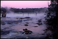
of course there are swamps everywhere, even canada, but they aren't cypress swamps, cypress trees only grow in the south which was my point. You don't think deciduous trees grow in the south? Look at the pictures I posted a few posts back asking you which states you thought they were from. You said they were from the north, but guess what, you are wrong...the first two, one of which has snow, are georgia. Only one of those is in the north, the one with the stream, the rest were from virginia, including the cypress swamp with spanish moss and alabama. I guess alabama and georgia look too much like the north to you too to be considered southern.
Please register to post and access all features of our very popular forum. It is free and quick. Over $68,000 in prizes has already been given out to active posters on our forum. Additional giveaways are planned.
Detailed information about all U.S. cities, counties, and zip codes on our site: City-data.com.

 Please register to participate in our discussions with 2 million other members - it's free and quick! Some forums can only be seen by registered members. After you create your account, you'll be able to customize options and access all our 15,000 new posts/day with fewer ads.