Please register to participate in our discussions with 2 million other members - it's free and quick! Some forums can only be seen by registered members. After you create your account, you'll be able to customize options and access all our 15,000 new posts/day with fewer ads.
Yeah, the whole world is one giant CSA! All God's children got a CSA!
I think I've created a monster. I had an earlier post where I was trying to say that a metro area can't be measured solely by the extent of the area with high population density, that you need some kind of interconnectedness between nearby towns and cities for one area to have metropolitan character. I suggested that IF the more or less unbroken spread of density were enough to identify the boundaries of a metro area, the entire BosWash region would be one gigantic metro. The whole point was to use the fact that BosWash is NOT all one huge metro area to emphasize that you need more than just a spread of population density to define a metro. Apparently I didn't word that post so well, and some people took it that I was saying BosWash was one CSA. The Charlanta/Chipitts post looks like a response saying like hey, wait a minute, if BosWash is all one CSA, then would Charlanta or Chipitts fit into that category as well. Sorry for the confusion.
Ashtabula is not even included in the Cleveland metro, although it should be. You must not know a lot about Cleveland if you dont think Medina County should be included. Medina County is actually bordering Cuyahoga County where Cleveland is located, and is completely connected to Cleveland. I have no idea why you would think it shouldnt be included when you think that counties 70 miles, and 3 counties away from St. Louis city should be included in its metro...Doesnt make any sense.
70 miles? Where are you getting that from? Ashtabula is more connected to Erie, Pennsylvania than it is to Cleveland. I suppose you want to include that too. Medina County also is rural in much of its area as I recall driving on Interstate 71 and seeing nothing besides farmland...you yourself said that any rural area shouldn't be included...if St. Louis can't have the counties that are rural, why should Cleveland be an exception? Maybe you should just leave this topic alone. You must also not know much about St. Louis if you think Lincoln County is 70 miles away from it. If my memory serves me right, it's about 50 miles away, not 70. Either way, you could drop that county and St. Louis' metro population would hardly be impacted...drop 3 counties, you're down about 100,000 people. There is no way to form a universal definition of a metro area. The geography of a place can impact the way a population is spread out. Cleveland is on a lakeshore...the tendency for a population to cluster is likely greater. St. Louis is not on a lakeshore, merely on two rivers, and has a great amount of land to spread out on all sides. More room means less cluster. Half of my family is from Cleveland...I never noticed it to be much denser than St. Louis, both cities are very similar in size, and size has never been a universally accepted definition since no two areas are exactly identical. We are going to have to agree to disagree....neither one of us is going to be right in the ultimate sense anyway.
The use of counties in western states skews the geography. Counties are very large in the west.
For example, the Fresno MSA is over 6,000 sq miles. Fresno County is larger than Rhode Island, or Delaware, or Connecticut. The Fresno MSA stretches for over 100 miles from east to west.
Another example is Los Angeles. By including Riverside and San Bernardino counties that metro area ends up including the Mojave Desert, not too many people living there. The Los Angeles metro region ends up being defined as a huge area stretching from the Pacific to Arizona, a distance of roughly 200 miles.
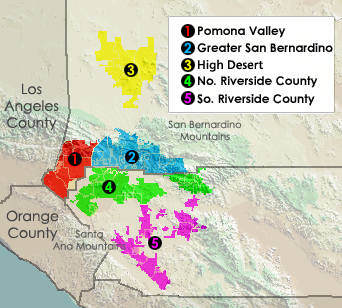
Not really when they include riverside and San Bernandino county they don't include all of the county they only include These regions not the whole regions b/c nobody really lives in the desert which is why they don't include the Eastern halfs of Riverside and San bernandino counties just the western halfs of the counties.Near Oc and La Counties.
These are the only regions that count to La's metro not the whole RV and SB Counties, And even with RV and SB LA is still a smaller Land wise metro than Chicago and NYC.
Thats true. But how do they do it? Does someone who lives in FAR east SB and RV county get the same television market and news as someone who lives in LA and Orange county? just wondering.
And also where is the didviding line in RV and SB counties between LA metro and the straight ip desert? When do you officially leave LA metro in SB and RV counties?
Not really when they include riverside and San Bernandino county they don't include all of the county they only include These regions not the whole regions b/c nobody really lives in the desert which is why they don't include the Eastern halfs of Riverside and San bernandino counties just the western halfs of the counties.Near Oc and La Counties.
These are the only regions that count to La's metro not the whole RV and SB Counties, And even with RV and SB LA is still a smaller Land wise metro than Chicago and NYC.
No, the Census Bureau and OMB both use all of Riverside and San Bernardino counties.
There is the Los Angeles-Long Beach-Riverside CSA which consists of several smaller divisions.
Then there is the Riverside-San Bernardino-Ontario MSA which is part of the Los Angeles CSA.
But both include all of SB and Riverside Counties.
Check out one of the census bureau maps below, they are too large to insert in this post.
Actually here is a better map that shows only the Census Bureau's components in the Los Angeles-Long Beach-Riverside CSA. But again it includes the desert areas.
Im just simply saying that the St. Louis metro and CSA is greatly overextended. Especially if you want to compare it to other areas. You admitted yourself that the Cleveland metro and CSA may be very under-extended. I agree with that also.
Just look at these numbers, its pretty obvious:
Cleveland Metro:Land Area-2,004 sq miles: Population-2,096,471
St. Louis Metro:Land Area-8,649 sq miles: Population-2,803,707
Cleveland CSA:Land Area-2,909 sq miles: Population-2,896,968
St. Louis CSA:Land Area-9,098 sq miles: Population-2,866,517
Entire NE Ohio:Land Area-8,200 sq miles: Population-5,200,000
(The NE Ohio numbers arent exact, but pretty close)
As you can see the Cleveland metro and CSA are 3-4 times smaller in land area than the St. Louis metro and CSA, but they have close to the same amount of people, or more. This makes them overall 3-4 times denser than the St. Louis metro and CSA. Also, the entire Northeast Ohio area is smaller than both the St. Louis metro and CSA, but has nearly twice the amount of people. This means its over twice as dense as the St. Louis area. I understand how metros are formed, but I feel the population alone is very misleading, this being one of the most extreme cases. If you went by urban areas connected, Cleveland would be much larger than St. Louis. Cleveland is also surrounded by connected areas of high population, while St. Louis has virtually nothing surrounding the immediate area (which is much smaller than the current metro land area). This is all basic stuff.
41. Grand Rapids-Muskegon-Holland, MI CSA - 1,323,095
Getting back to the original idea of this thread... this one is a big stretch.
The 30 miles between Grand Rapids and Muskegon are absolutely rural. Dairy farms, gravel roads, corn fields, distinct villages of less than 1,000 people. Basically the same thing between Grand Rapids and Holland, although it's somewhat more populated.
An aerial of Zeeland, which is supposedly smack dab in the middle of the "metro area":
It's tough to argue that places like Trenton are more of the New York City area than they are Philly, but it's tough to argue that they aren't either. That section of the country (NYC to DC) overlaps heavily and as a result is hard to calculate which areas are SPECIFICALLY part of each metro area.
I think this sattelite map of Philly makes a complete mockery of the CMSA.
Trenton is the pink blob on the eastern side of the Delaware River in Phillys northern most metro.You can see its immediately connected with Philadlephia.However It gets included in NYC 's metro which you can see is 70 miles to the N, with a ton of rural area in between .
Also just to the immediate NW of Philly is Reading and Allentown which are not included in Phillys metro. Again how can the CMSA justify including Trenton in NYC's metro but Reading Allentown are not included in Philadlephia which is half the distance?
Please register to post and access all features of our very popular forum. It is free and quick. Over $68,000 in prizes has already been given out to active posters on our forum. Additional giveaways are planned.
Detailed information about all U.S. cities, counties, and zip codes on our site: City-data.com.

 Please register to participate in our discussions with 2 million other members - it's free and quick! Some forums can only be seen by registered members. After you create your account, you'll be able to customize options and access all our 15,000 new posts/day with fewer ads.