Please register to participate in our discussions with 2 million other members - it's free and quick! Some forums can only be seen by registered members. After you create your account, you'll be able to customize options and access all our 15,000 new posts/day with fewer ads.
As an avid road traveler and map collector, I've always been intrigued by the complexity of US Highway system as a whole, from interstates to US highways to local/rural routes. Equally intriguing is the sheer diversity of route shields and systems in different states. Here in Texas, we have:
farm-to-market (or ranch) roads: are the most rural of highways. They are usually two-laned and are generally the quickest way to get from one rural area to another.
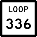
state highways: connect rural FM roads to interstates and US highways, and are often built to freeway standards in terms of capacity, especially in major urban areas. There are different types of state highways; the most common here are spurs, beltways, and loops.
I'm curious to see how other state/local routes are fashioned and emblematized.
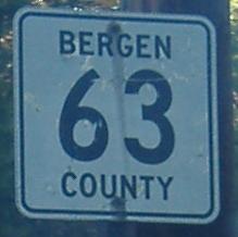
...with the exception of Bergen County, which has a lot of its "old-skool" signs up:
New Jersey still has a few of the old marker stones around, too. Imagine trying to find your way around relying on these:
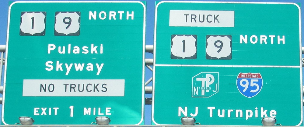
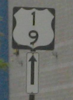
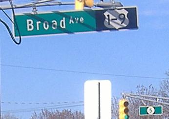
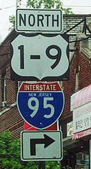
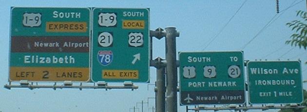
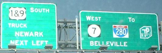
Another interesting thing is the non-standard way NJDOT signs the complex of Route 1 and Route 9. The two routes merge in Woodbridge and continue together to Fort Lee, roughly 25 miles. The DOT uses several different schemes for displaying these routes on signs, though. The randomness/lack of standard in the signage is funny to me.
Each of Florida's 67 counties have county roads, which are the lowest tier of public roads, aside from regular city streets. This is the standard sign, though occasionally when the state transfers control of a road to the county, they'll keep the state shield, but just add a C in front of the number.
http://upload.wikimedia.org/wikipedia/commons/thumb/4/43/Pinellas_County_Road_438_FL.svg/450px-Pinellas_County_Road_438_FL.svg.png (broken link)
State roads criss-cross the state. They generally are in numerical order from north to south, with evens running east and west and odds, north and south. Along with county roads, many state roads aren't signed, especially within cities.
Finally, we have regular US Highways and Interstates. Nothing exciting there. However, we used to have our own colored US Highway signs, until the Federal government stopped that sometime in the 90's. You can still see a few, but they're getting harder to find.
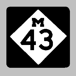
Anyone that lives here would refer to this as "M-43." There is no variation on this. The only other option for a local would be to call it by the actual name of the road, such as "Carlton Road."
If you call it "route 43" or "highway 43," you are instantly identified as an outsider!!
We also have county highways, but they are few and far between. They sometimes aren't even marked, and are not found on all maps. The county I grew up in didn't have a single county highway. But where they do exist, the signs look like this:
New Jersey still has a few of the old marker stones around, too. Imagine trying to find your way around relying on these:
Another interesting thing is the non-standard way NJDOT signs the complex of Route 1 and Route 9. The two routes merge in Woodbridge and continue together to Fort Lee, roughly 25 miles. The DOT uses several different schemes for displaying these routes on signs, though. The randomness/lack of standard in the signage is funny to me.
The old markers look more like gravestones, lol. And boy could US routes 1 and 9 be any more off the wall. If I didn't know any better, I'd probably be wondering where US routes 2 thru 8 were. Love the totally gratuitous "&" sign. And what does the "T" stand for?
The old markers look more like gravestones, lol. And boy could US routes 1 and 9 be any more off the wall. If I didn't know any better, I'd probably be wondering where US routes 2 thru 8 were. Love the totally gratuitous "&" sign. And what does the "T" stand for?
I think the 1-9 convention was adopted to save the DOT from placing separate shields for Route 1 and Route 9 on sign assemblies although it certainly bucks Manual for Uniform Traffic Control Devices (MUTCD) convention. I think I've seen some without the "-" as well, which makes it look as though you're on Route 19. The "T" stands for "Truck." Routes 1 and 9 travel over the Pulaski Skyway, which can't handle trucks, so there's a truck spur, called Truck 1 and 9. And, not surprisingly, the signage isn't consistent there either. NJDOT does a lot of things well such as jughandles, concrete barricades (ever hear of a "Jersey wall"?), but for some reason, they make a lot of "oopses" when it comes to signs.
Please register to post and access all features of our very popular forum. It is free and quick. Over $68,000 in prizes has already been given out to active posters on our forum. Additional giveaways are planned.
Detailed information about all U.S. cities, counties, and zip codes on our site: City-data.com.

 Please register to participate in our discussions with 2 million other members - it's free and quick! Some forums can only be seen by registered members. After you create your account, you'll be able to customize options and access all our 15,000 new posts/day with fewer ads.