Please register to participate in our discussions with 2 million other members - it's free and quick! Some forums can only be seen by registered members. After you create your account, you'll be able to customize options and access all our 15,000 new posts/day with fewer ads.
Your overall point still stands, but I just wanted to point out that it's the Charlotte-Gastonia-Salisbury, NC-SC CSA which has a population of 2,338,289. It includes the Charlotte-Gastonia-Concord MSA, which you correctly stated, plus seven micropolitan statistical areas which make up the difference.
Your overall point still stands, but I just wanted to point out that it's the Charlotte-Gastonia-Salisbury, NC-SC CSA which has a population of 2,338,289. It includes the Charlotte-Gastonia-Concord MSA, which you correctly stated, plus seven micropolitan statistical areas which make up the difference.
Several of his statistics were off...he left out some areas, like Athens, Columbus, Macon, and Winston-Salem - which would add about another million people. Also, the Southeastern Corridor doesn't stretch from Richmond to Montgomery...it's generally considered the area between Raleigh and Atlanta, loosely following I-85.
The BosWash ideohas been pretty much rejected by everyone except the NY Times company... And even they are starting to figure out how reductionist it is.
Totally passe, and invented by geographers with little understanding of how culture is produced or transitions though generations.
Your overall point still stands, but I just wanted to point out that it's the Charlotte-Gastonia-Salisbury, NC-SC CSA which has a population of 2,338,289. It includes the Charlotte-Gastonia-Concord MSA, which you correctly stated, plus seven micropolitan statistical areas which make up the difference.
I didn't include micropolitan areas in either region since they are exurban, and have very low densities and low populations.
Quote:
Originally Posted by DeaconJ
Several of his statistics were off...he left out some areas, like Athens, Columbus, Macon, and Winston-Salem - which would add about another million people. Also, the Southeastern Corridor doesn't stretch from Richmond to Montgomery...it's generally considered the area between Raleigh and Atlanta, loosely following I-85.
Well I-85 starts near Richmond (in Petersburg), which is the 3rd largest MSA on the corridor so I thought that it would be a suitable anchor city. You're right about the ones I missed, although the Athens area was below 200,000. I also forgot the Reading, PA MSA.
-------------
For this revision, I'm lowering the MSA requirement to ~150,000 since too many important areas were left off, but am still excluding micropolitan areas.
I-95 (DC to Boston): Baltimore-Washington CSA
Washington DC MSA (DC-MD-VA): 5,286,227
- Bethesda-Gaith.-Fred. MD
- Washington-Arl-Alex. MD Baltimore-Towson MSA (MD): 2,658,405 Hagerstown-Martinsburg MSA (MD-WV): 261,198
I-85:
Total pop.- 13,683,818/11,482,341
distance (Montgomery-Richmond/Atlanta-Raleigh)-692 mi./409 mi.
person/mi.- 19,774/28,074
So, the changes affect the results a little. The I-85 corridor still doesn't hold a candle to the I-95 BosWash though. I must say that I am still impressed by the I-85 Corridor. I didn't realize there were so many cities located along it besides the Triad/Research Triangle, Charlotte, Atlanta etc.
Okay...28,000 was about what I came up with for the Raleigh-Atlanta corridor. This gives a good idea of the actual cities included in the "emergent megalopolis", and it actually includes Birmingham to Raleigh and has a population of 19 million:
Quote:
The I-85 Corridor in the Southeastern United States: the same pair of studies define this areas as an "emergent" megalopolis including the primary cities of Birmingham, Atlanta, Greenville, Spartanburg, Charlotte, Winston-Salem, Greensboro, Durham and Raleigh.Both studies refer to the area as the Piedmont megalopolis; the Georgia Tech survey defines the region narrowly, focusing on the urban, suburban and rural counties between Birmingham and Raleigh. The Virginia Tech study proposes a broader definition, which would also include Columbus, Macon, Huntsville, Augusta, Columbia, Knoxville, Chattanooga, Johnson City, Asheville and a number of smaller cities; the western extent of this definition is somewhat disconnected by the Appalachian Mountains range. Both reports highlight the "emergent" nature of this possible megalopolis, noting comparatively low urban densities, but also noting a pattern in growth (in the individual, component urban areas) towards each other. As of 2005, this region (as defined in the Virginia Tech study) has a population of 19 million
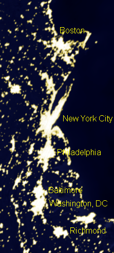
Obviously the name implies everything between Boston and Washington, but I've seen some define it as everything from Norfolk to Maine. What's your thoughts?
Imo the NE corridor stops in Northern Va and the SE corridor starts in Raleigh.
So by your definition, where does that leave the Richmond and Norfolk/Hampton Roads metro areas. From the picture above, Richmond to HR and Richmond to DC is less separated than NYC to Boston, thus both of these metros should be included in BosWash
Please register to post and access all features of our very popular forum. It is free and quick. Over $68,000 in prizes has already been given out to active posters on our forum. Additional giveaways are planned.
Detailed information about all U.S. cities, counties, and zip codes on our site: City-data.com.

 Please register to participate in our discussions with 2 million other members - it's free and quick! Some forums can only be seen by registered members. After you create your account, you'll be able to customize options and access all our 15,000 new posts/day with fewer ads.