Please register to participate in our discussions with 2 million other members - it's free and quick! Some forums can only be seen by registered members. After you create your account, you'll be able to customize options and access all our 15,000 new posts/day with fewer ads.
I think historical settlement patterns do have a lot to do with what makes New England so unique as a region. This uniqueness shows up even in the most unexpected places. For example, take this map that shows the distribution of small rivers called "brooks" (in blue) and "creeks" in (orange):
Although the use of "brook" does extend slightly into upstate NY and NJ, it is largely a marker of New England.
The original settlers of New England came predominantly from East Anglia (the counties of Norfolk, Suffolk, Cambridgeshire, and Essex in England). They brought many of the distinctive characteristics of their home region with them -- dialect, architecture, and religion (East Anglia was the Puritan stronghold), to name a few.
Just as the geographic boundaries of Appalachia are linked to the extent of Scots-Irish settlement in the South, New England is separated from the rest of the country by a boundary between settlement groups. Geographically speaking, this boundary lies just east of the Hudson River Valley, following the rugged terrain of the Litchfield Hills, the Berkshires, the Taconic Range and then along Lake Champlain. To the west of this boundary, the original settlers were Dutch:
(Note how the Mid-Atlantic states - NY, PA, etc. - were the original American "melting pot." New England was culturally and linguistically much more homogenous, and distinctly English).
The New England colonies also developed a very unique form of government, one which is still distinctive of the region today: the town meeting. This system is further emphasized by the division of the New England states into municipalities called New England towns. This form of governance is found only in the six New England states and nowhere else in the country. You may notice that on election night, other states' election results are reported by county -- but the results in New England are reported by town.
When colonial settlers established towns in New England, they constructed them around a common. The towns were very centralized; the meeting house, the church, and the schoolhouse were all built adjacent to the common, which was a shared grazing plot for the townspeople's cattle and also a place for the townspeople to meet and converse. There was a strong community-based mentality which I think is still very apparent in the region today.
New Englanders are sometimes criticized as being "clannish" or suspicious of outsiders, but I think this ties directly into the very strong community-based, local-based mentality. After all, the Yankees who remain in New England today are not those whose ancestors were drawn to the wild, open West; their ancestors were much more comfortable in their clustered, Old World villages. Subsequent waves of non-British immigrants -- notably from Ireland, French Canada, and Italy -- adapted to this clannish, small community-oriented culture.
Although New Englanders tend to be much more "British" in the sense that they are more reserved than other Americans (and are certainly much less forward and outgoing than their immediate neighbors in New York, generally), I believe that New Englanders are in fact extremely close within social groups and communities. In other words, a New Englander is not as gregarious or quick to make friends with a stranger as a Southerner, but when they do cultivate friends after time, they tend to be very loyal. Don't expect a New Englander to bake you a pie when you move into their neighborhood, but if your car gets stuck in the snow, neighbors that you've never spoken to will be there without being asked.
This brings us to the concept of social capital. The political scientist Robert Putnam evaluated this sense of "inter-connectivity" within communities across the United States, and mapped geographic patterns:
Interestingly, New England stands out as a bastion of relatively high social capital, in addition to those regions to which New England contributed most of the early American settlers -- the Upper Midwest and the Pacific Northwest. Of course, we should also note that these regions experienced heavy immigration from northern Europe, importing another culture deeply rooted in strong social capital. To some extent, one may argue that cultures originating in very cold or otherwise harsh climates show, by necessity, more inter-reliance among community members.
It is important to remember that, compared to the other Northeastern states, the terrain of New England is particularly inconducive to agriculture. In addition to the harsh climate (at the confluence of weather fronts from every direction), New England sits largely upon granite, and a lot of it (most of the US sits on limestone). Farmers used to quip that their best crop was stones -- and if you see all the stone walls in New England, you'll see all the work that was involved in clearing a field of stones. New England lost many farmers to the allure of more fertile land out west.
Observe the land use in the Northeast today:
New England also lost many farmers to the allure of financial stability provided by factory work. The region was the first to embrace the Industrial Revolution that it observed in Britain. As such, it was also the first region to experience de-industrialization and the move towards the service sector. New England is not undergoing the same kind of mass deindustrialization as in neighboring Northeastern states that belong to the Rust Belt.
There is also, I think, an important difference in political heritage between New England and other parts of the Northeast. New England has always been particularly receptive to emerging European idealogies and has long been a cradle of more "progressive" ideas. New England was the original stronghold of the Republican Party, back when its platform included things like abolitionism, women's rights, environmentalism, etc.
Today, most urban areas along the East Coast can be described as "liberal" or generally adhering to the principles of the modern Democratic Party, but New England stands out from other Northeastern states if you look at the big picture:
Every single county in New England (except for one) voted for Obama in the 2008 Election. Compare these results to those in the Mid-Atlantic states, where huge swaths of (mostly rural) areas voted Republican. While the Mid-Atlantic states appear to show a largely rural-urban divide, even the most rural areas of New England voted Democratic.
The answer for this, I believe, lies in a shared ideology of social libertarianism that is quite prevalent throughout New England. In other words, the "right wing" of New England politics - the "Yankee Republican" - can actually be described as "liberal" on social issues like religion, gay marriage, etc., compared to Republicans in other parts of the country. This libertarian philosophy is perhaps best captured in New Hampshire's state motto: "Live free or die."
It seems that this philosophy is deeply linked to the character of the region as a whole. I talked about the perception of New Englanders by outsiders as "reserved" or "aloof." But from a native's perspective, these traits are merely indicative of a desire to provide strangers with their privacy. There is a very strong sense of "live and let live," I think.
Did that answer your question?
As a person with a degree in geography, who maps demographic and environmental issues I say this with all due respect…but your maps and information a fairly dated (by about 70 years) lol.
First of all…the concept of “New England” as a unified region is falsely held almost universally outside the six states (ME, VT, NH, MA, RI, CT) and often accepted within the region…but this is nothing more than a historical carryover. Certainly, this was once a section of the United States with considerable cultural and economic uniformity (never a climatic uniformity). However, in the last 75 years… southern New England (MA, RI, and especially CT) has quickly become part of the Metro East Coast I-95 states. This is clear in the racial, ethnic, and reglious diversity of the southern states (again, especially CT)…and the lack of such in the northern states. Further complicating the issue is that Connecticut is often grouped with the Tri-State area (NYC/LI/NJ/CT)…and in terms of diversity, climate, and culture makes far more sense than to group it with places like ME and VT.
Next, those of “Yankee/English” ancestry are ghosts of the past in places like Connecticut and parts of Massachusetts and Rhode Island. The map of the ancestry by county below (map 1)…shows that those of Italian/Irish are now the “dominate” European ancestry for people in CT,MA, RI…the English long since being replaced. Yet one look in VT, ME, and NH…shows that with the exception of the French Canadians along the US/Canadian border…those of English ancestry still dominate.
In terms of other racial/ethnic diversities…once again MA, RI, and especially CT…share little with the northern New England States: One look at the map of Hispanic-American population by county… shows that Hispanics make up while 0 to 3% of the population of VT, NH, or ME (the actual number for VT, NH, and ME is 0.7%)… Connecticut has 3% to 12 % classified as Hispanic (the actual number is 10% for CT, are growing). In fact, the political Hispanic influence while so weak in the Northern New England States…is becoming very strong in places like Connecticut (map 3). Connecticut has the 4th highest per capita Hispanic population in the Eastern half of the USA...behind FL, NY, NJ. This is also true of the African-American population…13% of Connecticut total population is of African American ancestry…0.3% of VT, NH, and ME is.
The same can be said for the difference in religious diversity between places like CT or RI in the south and the Northern New England states: For example…the Jewish population is 300% higher per capita in CT, MA, and RI than in VT, NH, ME (4th map)…as is the Muslim population (5th map). In fact, New Haven, and Fairfield Counties in Connecticut…and the counties outside of Boston are home to more Muslims that about 90% of counties in America. Obviously, the same can’t be said for the Northern New England States.
The concept of prostant/ English cultural overtones in southern New England is not only a myth…but a very old one. Places like CT are no more “English/Yankee” in their culture than New Jersey. Here is a map by ERSI (diversity index summarizes racial and ethnic diversity). The index ranges from 0 (no diversity) to 100 (complete diversity). One glance at the map shows how there is so little diversity in Northern New England …and so much diversity in southern New England. This map really bats home how much MA, RI, and espically Connecticut are part of the Metropolation East Coast corridor and NOT part of New England. The social, cutural, economic, and regional influnce of New England is of little importance in places like CT or metro Boston/Providence.
Finally, in terms of climate…Connecticut and Rhode Island are in a completely different climate group (no type) than the region northern New England. Cities like New Haven, Ct share more in common with the climate of Trenton, NJ than with the climate of Concord, NH. Connecticut/Rhode Island/coastal MA is located in Koppen C climate groupe with much of the East Coast (Warm Temperate) ...while VT, NH, and ME are located in Koppens D climate groupe with SE Canada (Cold Temperate).
.
Last edited by wavehunter007; 11-09-2009 at 10:08 AM..
As a person with a degree in geography, who maps demographic and environmental issues I say this with all due respect…but your maps and information a fairly dated (by about 70 years) lol.
What on Earth is "dated" about my maps and information? Aside from the map of ethnic groups of colonial settlement areas, all of my data is current. And in case you didn't notice, the OP asked about the cultural characteristics of New England, which can't be extrapolated by just throwing out as many demographic maps as possible. I was born and raised in New England, and have lived and traveled outside of the region enough to understand what elements of the culture unify and distinguish New England from the rest of the country. A degree in geography does not make you an expert in the history or sociology of New England.
Quote:
Originally Posted by wavehunter007
First of all…the concept of “New England” as a unified region is falsely held almost universally outside the six states (ME, VT, NH, MA, RI, CT)
This is true, but what's your point? Many Americans don't understand the concept of "England" vs. "Great Britain" vs. the "United Kingdom", but what bearing does this misconception have on the reality of things? None.
Quote:
Originally Posted by wavehunter007
this is nothing more than a historical carryover.
What support do you have for this claim? You recognize that New Englanders themselves strongly associate with citizens of the other New England states, and yet you call the region a "historical carryover"? If a cultural region isn't defined by self-indentification, then how is it defined? Moreover, there is nothing "historical" about the current recognition of the region by the U.S. Census Bureau, the Federal Reserve System, and the Office of Management and Budget, not to mention a plethora of other government and non-government organizations and corporations.
Quote:
Originally Posted by wavehunter007
Certainly, this was once a section of the United States with considerable cultural and economic uniformity (never a climatic uniformity). However, in the last 75 years… southern New England (MA, RI, and especially CT) has quickly become part of the Metro East Coast I-95 states.
I certainly recognize the divide between the more rural northern New England and the more urban southern New England. But urban/rural divides exist in every cultural region of the United States. The bottom line is that, on a cultural level, stripping away any aspects of lifestyle that can be attributed solely to living in an urban environment or a rural environment, someone in Massachusetts has more in common with someone in Maine than they do with someone in New York, and this is widely recognized by natives.
Quote:
Originally Posted by wavehunter007
Further complicating the issue is that Connecticut is often grouped with the Tri-State area (NYC/LI/NJ/CT)…and in terms of diversity, climate, and culture makes far more sense than to group it with places like ME and VT.
In my original post, I did not address the problematic case of Connecticut. While once solidly culturally part of New England, the expansion of the NYC metro area into the state has imported a culture distinct to that city and its sphere of influence. However, the extent of this cultural sphere does not reach across the entire state; it is largely confined to the southwestern corner.
Observe this map from the CommonCensus Map project, which asks respondents to indicate the large city that they most identify with:
You'll see that the vast majority of New Englanders identify themselves with Boston, which is still the economic and cultural hub of the region. The cultural divide running through Connecticut is also apparent here.
If you visit the CommonCensus website, you'll see respondents' answers to the question: "On a global level, what three geographic areas do you most identify with?", ranked in order of strongest identification to weakest identification.
Interestingly, "New England" shows up fairly high in the "#1 Choice for Identity" column, with 367 respondents. The only regional identity ranked higher is "Midwest," with 690 respondents. However, taking into consideration the ratio between the two populations - New England with about 14 million people and the Midwest with about 65 million - the New Englanders' regional identification has the strongest weight of any on the list.
Quote:
Originally Posted by wavehunter007
Next, those of “Yankee/English” ancestry are ghosts of the past in places like Connecticut and parts of Massachusetts and Rhode Island. The map of the ancestry by county below (map 1)…shows that those of Italian/Irish are now the “dominate” European ancestry for people in CT,MA, RI…the English long since being replaced. Yet one look in VT, ME, and NH…shows that with the exception of the French Canadians along the US/Canadian border…those of English ancestry still dominate.
With a degree in geography, I'm incredibly surprised that you're making this argument based on a map that oversimplifies and obscures the complex reality of ancestry groups in New England.
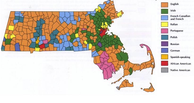
First of all, the claim that people of English ancestry are "ghosts of the past" in southern New England is laughable. While people of Irish and Italian ancestry do dominate the cities and their immediate suburbs, the county-wide categorizations in the Census map completely mask the extent of English ancestry in the less populated towns. Here's a map of dominant ethnic groups by town in Massachusetts (Historical Atlas of New England, Wilkie and Tager):
Notice that Wilkie and Tager do one important thing that the Census Bureau doesn't: collapse "French" and "French-Canadian" ancestry into one group. Many New Englanders of French-Canadian ancestry aren't sure about their heritage or will simply mark "French" when in reality, the vast majority of people of French heritage in New England are descendants of Québécois immigrants.
Taking this into consideration, a re-drawn map based on the same Census data looks dramatically different:
Still, this county-wide categorization really obscures what's going on.
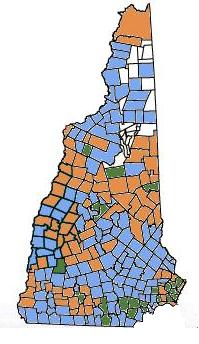
I took it upon myself to draw a map similar to Wilkie and Tager's for New Hampshire based on Census data, and here is the result:
The extent of towns with dominant English ancestry is in fact arguably smaller than in Massachusetts due to the very large French-Canadian population.
However, the most important point is that even at the town level, we are not seeing the full picture. We are not dealing with "blocs" of ethnic groups in New England; the top ancestry group in a given town usually leads by one or two percentage points, with the four "big" groups - English, French-Canadian, Irish, and Italian - usually pretty comparable in every single town. The same holds true for southern New England.
Quote:
Originally Posted by wavehunter007
In terms of other racial/ethnic diversities…once again MA, RI, and especially CT…share little with the northern New England States: One look at the map of Hispanic-American population by county… shows that Hispanics make up while 0 to 3% of the population of VT, NH, or ME (the actual number for VT, NH, and ME is 0.7%)… Connecticut has 3% to 12 % classified as Hispanic (the actual number is 10% for CT, are growing). In fact, the political Hispanic influence while so weak in the Northern New England States…is becoming very strong in places like Connecticut (map 3). Connecticut has the 4th highest per capita Hispanic population in the Eastern half of the USA...behind FL, NY, NJ. This is also true of the African-American population…13% of Connecticut total population is of African American ancestry…0.3% of VT, NH, and ME is.
The same can be said for the difference in religious diversity between places like CT or RI in the south and the Northern New England states: For example…the Jewish population is 300% higher per capita in CT, MA, and RI than in VT, NH, ME (4th map)…as is the Muslim population (5th map). In fact, New Haven, and Fairfield Counties in Connecticut…and the counties outside of Boston are home to more Muslims that about 90% of counties in America. Obviously, the same can’t be said for the Northern New England States.
Again, no one is arguing against these points, but what evidence do you have that these demographic features really indicate such a radical cultural divide? Diversity correlates directly with population density, and the same is basically true in every other region of the northern United States. You seem to be arguing that just because Boston has more minorities than say, Manchester, New Hampshire, that it is culturally more similar to New York City or Philadelphia. Moreover, I would argue that if you remove the top couple of most populated cities in each New England state, they are all very close in terms of a high percentage of white population.
Quote:
Originally Posted by wavehunter007
The social, cutural, economic, and regional influnce of New England is of little importance in places like CT or metro Boston/Providence.
Now you've completely lost me here. How is the social, cultural, economic and regional influence of New England not relevant in metro Boston or Providence? These places contribute largely to defining that very influence. Northern New England looks to Boston and Providence for economic opportunities and cultural trends, not to New York City.
Quote:
Originally Posted by wavehunter007
Finally, in terms of climate…Connecticut and Rhode Island are in a completely different climate group (no type) than the region northern New England. Cities like New Haven, Ct share more in common with the climate of Trenton, NJ than with the climate of Concord, NH. Connecticut/Rhode Island/coastal MA is located in Koppen C climate groupe with much of the East Coast (Warm Temperate) ...while VT, NH, and ME are located in Koppens D climate groupe with SE Canada (Cold Temperate).
I know you're obsessed with the climate of southern New England, but the OP was asking about the cultural characteristics of New England, not the climactic characteristics.
Funnily enough, despite its current reputation, Vermont was dominated by the Republicans until recently. I think the change was due to an influx of urban liberals from NYC and other placers who wanted to go "organic". That changed the demography of the state.
Started with hippies in the 60's. The state was always fairly libertarian in politics so they were tolerated for the most part...and now they're running the state (into the ground financially I might add but that's a topic by itself).
The quaint towns and history. Also, the only states in the country where the rural areas are also liberal. Plus, the best schools are located there.
The rural areas tend to be a mix of libertarian and conservative not liberal in Northern New England. Even though many democrats get elected in the Northeast Kingdom of VT, for instance, they are nowhere close usually to the far-left democrats of MA or NJ or such. Likewise the Republicans here in Northern New England are nowhere near being like the religious right conservatives of the South.
NY will never be New England, NY is New Holland. We VT'ers fought a war against NY once too, to keep NY hands off New England lands, keep in mind.
I think you mean New Netherland.
Interestingly, after the conquest of the Dutch, New York WAS part of New England, more than 100 years before Vermont even existed. New York also owned Nantucket, Martha's Vineyard and a big part of Maine until the 1690s.
Likewise, my county of Suffolk on Long Island was part of Connecticut in the 1600s. The modern day boundary between Nassau and Suffolk was once an international boundary between The Netherlands and England!
But even during the Dutch period, people escaping from the tyrannical Puritians were moving into the heart of New Netherlands itself. People like the couragerous Lady Deborah Moody (Brooklyn), the Quaker leader John Bowne (Queens) and the tragic Anne Hutchinson (The Bronx).
In fact at its greatest extent, New England briefly included the Jerseys (New Jersey) and had Boston as the main capital and NYC as a secondary capital for the Lt Governor!
As to "keep NY hands off New England lands", I would say keep in mind there are two sides to every story. To both the New York and British governments, the VTer's were ILLEGAL SQUATTERS. These settlers swarmed into the wilderness with grants from New Hampshire, which did not own the land and ignored Indian (Abenaki) claims and the Indian Reserve of 1763.
Yet, on the other hand if New York had recognized the VT'ers (Green Mountain Boys) land claims, maybe the beautiful state of Vermont would not exist. Large parts of the Green Mountain State would probably be a giant state park for escaping city residents like the Adirondacks.
True, New Netherland is the "correct" name but New Holland has a better sound to it, and has been used occasionally (just as Holland is sometimes used rather than The Netherlands).
It's funny that people always disagree when I say NJ is part of Southern New England but NJ history is completely intertwined with that of its New England neighbors.
We VT'ers beat the NY'ers to the land, from a New England state (one my family helped create), NH. NY as New Netherland never had claim to the land until they were controlled by the British and were in search of more land to settle. The Green Mountain Boys were freedom fighters. The Indians' claims weren't respected by either side anyways. Good thing we had Ethan Allen too, I like the greater level of freedom in VT, but I wish he had prevailed later on and we never became a state. I do believe our war is what ended any claim NY had on being part of New England. Culturally the two states are not very much alike other than some small rural parts of Northern NY.
Governor Kunin (a flatlander as we call them) wanted to turn VT into a big park in fact...so we got rid of her and elected a real VT'er (who unfortunately died in office and left us with Governor Dean).
Interestingly, after the conquest of the Dutch, New York WAS part of New England, more than 100 years before Vermont even existed. New York also owned Nantucket, Martha's Vineyard and a big part of Maine until the 1690s.
Likewise, my county of Suffolk on Long Island was part of Connecticut in the 1600s. The modern day boundary between Nassau and Suffolk was once an international boundary between The Netherlands and England!
But even during the Dutch period, people escaping from the tyrannical Puritians were moving into the heart of New Netherlands itself. People like the couragerous Lady Deborah Moody (Brooklyn), the Quaker leader John Bowne (Queens) and the tragic Anne Hutchinson (The Bronx).
In fact at its greatest extent, New England briefly included the Jerseys (New Jersey) and had Boston as the main capital and NYC as a secondary capital for the Lt Governor!
As to "keep NY hands off New England lands", I would say keep in mind there are two sides to every story. To both the New York and British governments, the VTer's were ILLEGAL SQUATTERS. These settlers swarmed into the wilderness with grants from New Hampshire, which did not own the land and ignored Indian (Abenaki) claims and the Indian Reserve of 1763.
Yet, on the other hand if New York had recognized the VT'ers (Green Mountain Boys) land claims, maybe the beautiful state of Vermont would not exist. Large parts of the Green Mountain State would probably be a giant state park for escaping city residents like the Adirondacks.
I knew Suffolk County was part of Connecticut but I never put that together. Its funny to think that the Suffolk County/Queens County (modern day Nassau County) border was an international border.
I can't say I haven't been to another country lol j/k.
Please register to post and access all features of our very popular forum. It is free and quick. Over $68,000 in prizes has already been given out to active posters on our forum. Additional giveaways are planned.
Detailed information about all U.S. cities, counties, and zip codes on our site: City-data.com.

 Please register to participate in our discussions with 2 million other members - it's free and quick! Some forums can only be seen by registered members. After you create your account, you'll be able to customize options and access all our 15,000 new posts/day with fewer ads.