...ERNESTO EXPECTED TO PASS NEAR OR JUST NORTH OF THE COAST OF
HONDURAS TONIGHT...
SUMMARY OF 800 AM EDT...1200 UTC...INFORMATION
----------------------------------------------
LOCATION...15.2N 81.0W
ABOUT 145 MI...235 KM E OF CABO GRACIAS A DIOS ON NIC/HON BORDER
ABOUT 380 MI...610 KM E OF ISLA ROATAN HONDURAS
MAXIMUM SUSTAINED WINDS...50 MPH...85 KM/H
PRESENT MOVEMENT...W OR 275 DEGREES AT 12 MPH...19 KM/H
MINIMUM CENTRAL PRESSURE...1003 MB...29.62 INCHES
SUMMARY OF WATCHES AND WARNINGS IN EFFECT...
A TROPICAL STORM WARNING IS IN EFFECT FOR...
* THE COAST OF HONDURAS FROM THE HONDURAS/NICARAGUA BORDER WESTWARD
TO PUNTA SAL...INCLUDING THE BAY ISLANDS
A HURRICANE WATCH IS IN EFFECT FOR...
* THE YUCATAN PENINSULA OF MEXICO FROM CHETUMAL TO PUNTA GRUESA
A TROPICAL STORM WATCH IS IN EFFECT FOR...
* GRAND CAYMAN
* THE COAST OF HONDURAS FROM WEST OF PUNTA SAL TO THE
HONDURAS/GUATEMALA BORDER
* THE YUCATAN PENINSULA OF MEXICO FROM NORTH OF PUNTA GRUESA TO
TULUM
DISCUSSION AND 48-HOUR OUTLOOK
------------------------------
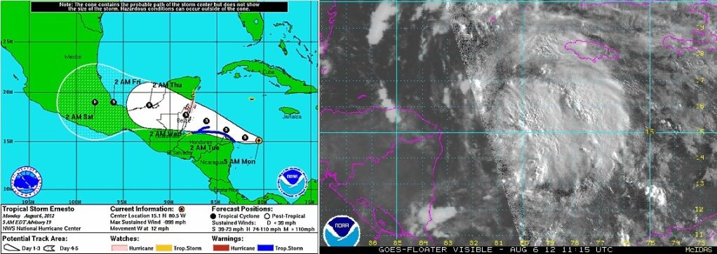
AT 800 AM EDT...1200 UTC...THE CENTER OF TROPICAL STORM ERNESTO WAS
LOCATED NEAR LATITUDE 15.2 NORTH...LONGITUDE 81.0 WEST. ERNESTO IS
MOVING TOWARD THE WEST NEAR 12 MPH...19 KM/H. A TURN TOWARD THE
WEST-NORTHWEST IS EXPECTED LATER TODAY...AND THIS MOTION IS EXPECTED
TO CONTINUE THROUGH EARLY WEDNESDAY. ON THE FORECAST TRACK THE
CENTER OF ERNESTO IS EXPECTED TO MOVE NEAR OF JUST NORTH OF THE
NORTH COAST OF HONDURAS TONIGHT AND TUESDAY AND APPROACH THE EAST
COAST OF THE YUCATAN PENINSULA TUESDAY NIGHT.
MAXIMUM SUSTAINED WINDS ARE NEAR 50 MPH...85 KM/H...WITH HIGHER
GUSTS. SOME STRENGTHENING IS FORECAST DURING THE NEXT 36 TO 48
HOURS.
TROPICAL STORM FORCE WINDS EXTEND OUTWARD UP TO 125 MILES...205 KM
FROM THE CENTER.
THE ESTIMATED MINIMUM CENTRAL PRESSURE IS 1003 MB...29.62 INCHES.

 Please register to participate in our discussions with 2 million other members - it's free and quick! Some forums can only be seen by registered members. After you create your account, you'll be able to customize options and access all our 15,000 new posts/day with fewer ads.


