Atlantic - Beta forms September 18, 2020 (tornadoes, days, storms, city)
Please register to participate in our discussions with 2 million other members - it's free and quick! Some forums can only be seen by registered members. After you create your account, you'll be able to customize options and access all our 15,000 new posts/day with fewer ads.
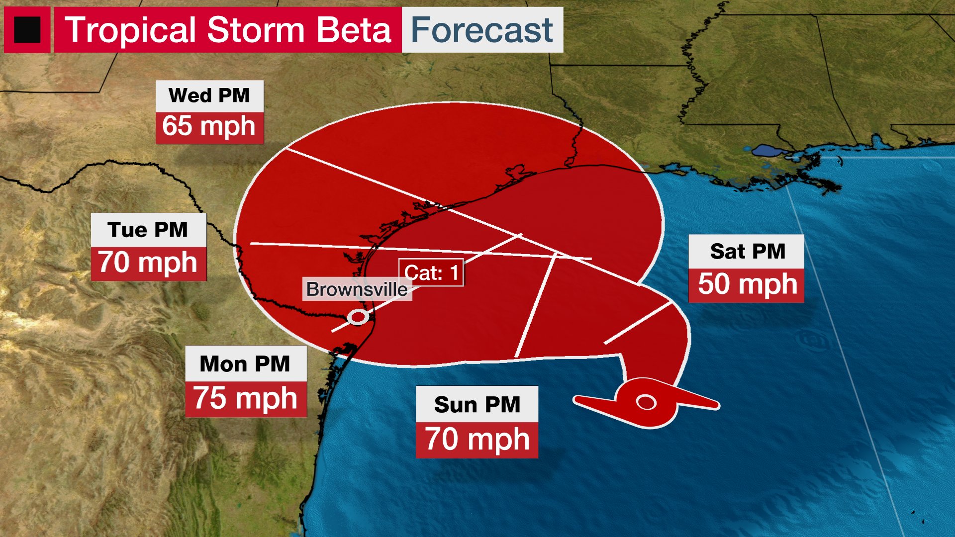
In Western Gulf of Mexico:
Fri 18Sept 4pCDT,5pEDT/AST Tropical Storm Beta forms (formally 90L, TD22).
Winds 40mph(65km/h)
Moving NNE 9mph(15km/h)
Pressure 1004mb
Center about 335miles(545km) ENE of Tampico, Mexico
Center about 280miles(450km) ESE of TX/Mexico border
Meandering around in the Western Gulf. Some wind shear affecting it currently. The thinking per NHC's discussion page is a trough over TX helps steer it more NE, then ridge builds in kicks it back West, then another trough expected pulls it back N/NE. All at slow movement speed, intensity may go up/down during all this. Rip current risk across the Gulf. For now that's a lot of rain potential if gets close to land at any time. Some moisture already being pulled up into LA/MS region.
Official updates are released by NHC every 6hrs at 4 & 10a/pCDT (5,11a/pEDT), if Watch/Warning posted then they add updates at 1 & 7a/pCDT (2,8a/pEDT): https://www.nhc.noaa.gov/
Fri evening model data suggest slow moving storm could bring rains along much of coastal Texas Sunday through Thursday next week or so then up into Louisiana. All going to depend on final track on who sees how much. Evening air recon data would seem to support a bump up to 60mph+/- here at 11pEDT/10pCDT update later. But that’s it for me for the nite.
Sat 19Sept 4aCDT,5aEDT/AST
Winds 60mph(95km/h)
Moving N 8mph(13km/h)
Pressure 996mb
Center about 290miles(470km) E of TX/Mexico border
Center about 300miles(480km) SW of mouth of MS River
No real changes, turns back W/NW by Sunday, slow turn back NE along TX coast dumping rains much of next week. Model guidance keeps as TS or briefly Cat1.
Watch/Warnings:
-Storm Surge Watch Port Mansfield, TX to Cameron, LA (includes Bay's/Lakes) for 1-4ft
-Hurricane Watch Port Aransas to High Island, TX
-TS Watch S of Port Aransas to TX/Mexico border.
-TS Watch E of High Island, TX to Morgan City, LA.
Sun 20Sept 7aCDT,8aEDT/AST
Winds 60mph(95km/h)
Moving WNW 3mph(6km/h)
Pressure 997mb
Center about 200miles(320km) SE of Galveston, TX
Center about 290miles(460km) E of Corpus Christi, TX
TS winds extend up to 195miles(315km) from center, mainly to the North, W & E of center.
Please register to post and access all features of our very popular forum. It is free and quick. Over $68,000 in prizes has already been given out to active posters on our forum. Additional giveaways are planned.
Detailed information about all U.S. cities, counties, and zip codes on our site: City-data.com.

 Please register to participate in our discussions with 2 million other members - it's free and quick! Some forums can only be seen by registered members. After you create your account, you'll be able to customize options and access all our 15,000 new posts/day with fewer ads.