Please register to participate in our discussions with 2 million other members - it's free and quick! Some forums can only be seen by registered members. After you create your account, you'll be able to customize options and access all our 15,000 new posts/day with fewer ads.
After ~ten years this is finally a reality. Congratulations to all those who worked tirelessly to achieve this result.
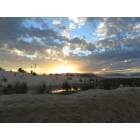
"Billy the Kid's hideout and a moon-like crater that served as the training ground for Apollo missions are among the almost half a million acres in southern New Mexico that will become America's newest national monument on Wednesday."
I need someone to explain to me why the actual Organ Mtns., including Aguirre Springs, are not within the boundaries of the designated park? The map shows the park to be located in the foothills to the west of the actual mountain. Most of that is rather boring/uninteresting desert by comparison.
Tomorrow President Obama will designate 500,000 acres of land in an around the Organ Mountains as the nation's newest National Monument. What are your thoughts on the new Organ Mountains-Desert Peaks National Monument?
Is it a wonderful new feather in New Mexico's cap and a welcome boon to it's tourist industry and reputation for natural beauty?
Or...
Is it a frightening over-reach and de facto land-grab by an over-zealous administration that is misusing the Antiquities Act?
I need someone to explain to me why the actual Organ Mtns., including Aguirre Springs, are not within the boundaries of the designated park? The map shows the park to be located in the foothills to the west of the actual mountain. Most of that is rather boring/uninteresting desert by comparison.
After a closer look, I do see that it includes the northern end of the Organs just to the south of San Augustin pass but not the southern end, which may well be part of White Sands Missile Range, although the map does not indicate anything of the missile range.
Aguirre Springs already being a state park may be the reason it's excluded.
As for the comment about "land grab" - most of the land is already federally owned, and what is privately owned within those larger boundaries I assume is excluded from park designation. Nothing has been said about "imminent domain" or other "land grab" measures on private lands.
Thanks for the map! I was searching for one like that and couldn't find it.
Just east of Dripping Springs is part of Fort Bliss. Just north of that the boundary is pushed to the east, so it looks like they included most of the mountain between Dripping Spring road and US70. That's most of what you typically see in photographs of the mountains from the west.
And I thank you for the reference to that photo. I'd never seen a detailed naming of various parts of the range.
Interesting to note that the Talavera subdivision is surrounded on three sides by the park boundaries. I have to wonder what impact that will have on existing homeowners there? It certainly precludes any further expansion of that development. If you don't know where that is, it's just to the east of the "A Mountain" and the Dripping Springs state park allotment.
Please register to post and access all features of our very popular forum. It is free and quick. Over $68,000 in prizes has already been given out to active posters on our forum. Additional giveaways are planned.
Detailed information about all U.S. cities, counties, and zip codes on our site: City-data.com.

 Please register to participate in our discussions with 2 million other members - it's free and quick! Some forums can only be seen by registered members. After you create your account, you'll be able to customize options and access all our 15,000 new posts/day with fewer ads.