This is exactly what makes Long Island so unique, interesting, and fun!
The North Shore has more hilly terrain and reminds me alot of Westchester and the Hudson Valley. The South Shore is flat, and reminds me more of Southern New Jersey, particularly as you head east, with it's rivers, wetlands, and swamps.
Of course LI's terrain also changes from west to east.
In the western part, particularly Nassau, the middle and northern parts have the hills, but the south shore and central Nassau areas are flat. As one moves east the spine of hills moves toward the middle. This is all due to the effects of the last Ice Age, while the south shore and parts of the middle were part of an old outwash plain, the hills were pushed up and carved by the glaciers. This Moraine runs down the spine of the island. In Nassau, it's highest places are along the Harbor Hill Moraine, in Roslyn for example.
In Suffolk, the Ronkonkoma Moraine has some LI's high points, such as Bald Hill in Selden, or the Manorville Hills further east. This same moraine actually stretched onto the south fork, which has more hills than the relatively flat north fork, such as in North Sea.
Before suburbanization, Long Island had several great ecosystems. My favorite, the largest of what remains, is the Pine Barrens. Nassau mostly had the Hempstead Plains, which were a large prairie grassland that stretched into Queens, to the north, hardwood forests, and to the south, swamps of the south shore.
The Pine Barrens actually an influence into Nassau from as far west as what is now East Meadow, and there's quite a few Pitch Pines in the Eisenhower Golf Course, as well as some in the park itself and even on some streets in East Meadow itself by what is now a TOH water facility. And Bethpage was probably where the Pine Barrens began in ernest, Bethpage State Park, for instance has many Pines.
The Pine Barrens reached all the way down to the south shore from Massapequa on east. And as one works further east, toward what is now Smithtown, the Pine Barrens intermingled with hardwood forests of the north shore. Even in Wildwood State Park, Pitch Pines are present.
Unlike New Jersey's Pine Barrens, Long Island's have some pretty decent hills, such as in Manorville Hills, Rocky Point,etc. Rocky Point actually has a unique "sandhills" area, featuring smaller Pitch Pines and large sand hills that was carved by glaciers. There are only 2 other places like this on Long Island, one, called Friar's Head, was unfortunetly developed into a Golf Course. The other, in Quogue off Spinney Road, is the subject a battle to save them, as another developer wants to build a luxury golf course here. But we are getting major support to save them, as actor Alec Baldwin has now joined the battle to preserve this land.
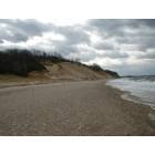
Here's what these sandhills look like in Rocky Point preserve. An absolutely beautiful, unique place to Long Island.


Another unique feature of Long Island are kettle hole ponds (again not present in NJ Pines). These can dry up during dry periods. There's several, some large (like Lake Ronkonkoma) and some small (like the Tarkill Ponds in Brookhaven State Park). These were caused by large chunks of the glacier causing depressions in the ground.

Then another unique environment are the barrier islands, places like the Fire Island National Seashore, with unique forests and coastal ecosystems such as the Sunken Forest, where stunted trees grow in the swale protected from salt spray by the dunes. This ecosystem also exists in Napeague, known as the Napeague Dunelands, which is forest of Pitch Pines in the dunes east of Amagansett. As one heads east the hills pick up again toward Montauk Point and hardwood forests come back, with more of a North Shore look.
Climates can vary widely as well, such as in summer, when the north shore is baking, while the south shore can be as much as 20 degrees cooler with a seabreeze. There's also areas in the Pine Barrens so flat, sandy, such as the dwarf Pine Plains in Westhampton, where temperatures are night can be quite a bit cooler than other areas due to the excellent conditions for radiational cooling. On a calm, clear winter night, temperatures in the single digits are actually quite common here.
It is unfortunate that many of these ecosystems have been lost. The Hempstead Plans is the real tragedy, only small portions remain around Eisenhower Park and Nassau Community College.
Much of the Pine Barrens have been lost, especially in western Suffolk. Edgewood Preserve is a good example of what the area was like before it was developed. But further east, many parks and preserves have kept them intact. Same for the North Shore hardwoods, alot exists privately in Nassau, with some parks as well. Better places east, such as Caumsett and Nissequogue.
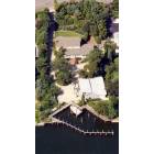
Much of the south shore wetlands have been lost, but there's still some nice (albiet small) parks like Mill Lake in Wantagh. Again, better examples east. The barrier islands are the one place that have been protected mostly from development, except for Long Beach, most are parklands or small beach towns (like Saltaire).
Long Island has actually done a much better job preserving it's oceanfront areas versus New Jersey, but its the complete opposite when it comes to the Pine Barrens. It's unfortunate plans for developments won't die even with the widespread knowledge that so much has been lost already. I hope the more folks learn about the importance of these places the more likely everything that is left will be saved.

 Please register to participate in our discussions with 2 million other members - it's free and quick! Some forums can only be seen by registered members. After you create your account, you'll be able to customize options and access all our 15,000 new posts/day with fewer ads.


 But this is a topic for an entire new thread, which has been done many a time before, haha.