Weather Alerts for Summer 2011 (First post is highway Web Cams) (Billings: tornado, dangerous)
Please register to participate in our discussions with 2 million other members - it's free and quick! Some forums can only be seen by registered members. After you create your account, you'll be able to customize options and access all our 15,000 new posts/day with fewer ads.
the national weather service in glasgow has extended the
* flood warning for small streams in...
Garfield county in northeast montana...
Mccone county in northeast montana...
Phillips county in northeast montana...
Southwestern daniels county in northeast montana...
Valley county in northeast montana...
* until noon mdt thursday.
* at 948 pm mdt creeks and streams across
garfield...mccone...phillips...valley and southwestern daniels
counties continue to run out of their banks as a result of recent
rain. Minor flooding was reported on cherry creek northwest of
glasgow. A downward trend is expected through thursday
morning...with creeks and streams expected to return to within their
banks by midday.
A flood warning means that flooding is imminent or has been reported.
Stream rises will be slow and flash flooding is not expected.
However...all interested parties should take necessary precautions
immediately.
Precautionary/preparedness actions...
Excessive runoff from heavy rainfall will cause elevated levels on
small creeks and streams...and ponding of water on country roads and
farmland along the banks of creeks and streams.
Do not drive your vehicle into areas where the water covers the
roadway. The water depth may be too great to allow your car to cross
safely. Move to higher ground.
To report flooding...have the nearest law enforcement agency relay
your report to the national weather service forecast office.
Flood watch
national weather service billings mt
1003 am mdt thu may 19 2011
.a strong low pressure system will move slowly out of the great
basin and into the northern plains today through sunday. This
system has the potential to produce widespread heavy rainfall
over the region. With soil already saturated by last weeks storm
system and snowmelt beginning to fill rivers and streams...
Widespread heavy rainfall could result in flooding across the
area.
Mtc003-009-011-017-025-037-065-067-075-087-095-097-103-107-111-
wyc033-201615-
/o.con.kbyz.fa.a.0002.000000t0000z-110523t0000z/
/00000.0.rs.000000t0000z.000000t0000z.000000t0000z. oo/
big horn-carbon-carter-custer-fallon-golden valley-musselshell-
park-powder river-rosebud-stillwater-sweet grass-treasure-
wheatland-yellowstone-sheridan-
including the cities of...hardin...crow agency...red lodge...
Bridger...joliet...ekalaka...miles city...baker...ryegate...
Lavina...roundup...livingston...broadus...colstrip ...lame deer...
Forsyth...columbus...absarokee...big timber...hysham...
Harlowton...billings...sheridan
1003 am mdt thu may 19 2011
...flood watch remains in effect through sunday afternoon...
The flood watch continues for
* portions of montana and north central wyoming...including the
following counties...in montana...big horn...carbon...
Carter...custer...fallon...golden valley...musselshell...
Park...powder river...rosebud...stillwater...sweet grass...
Treasure...wheatland and yellowstone. In north central
wyoming...sheridan.
* through sunday afternoon
* between 2 to 4 inches of rainfall will be possible with this
storm system. Locally higher amounts are possible...
Particularly along the northeast slopes of the beartooth and
big horn mountains.
* streams and creeks will rise quickly under areas of heavy
rain. Rainfall over the northeast facing slopes of the
beartooth... Absaroka...crazy and big horn mountains could
result in rapid rises on area rivers. Residents near streams
and rivers should remain alert for possible flooding.
Precautionary/preparedness actions...
A flood watch means there is a potential for flooding based on
current forecasts. Monitor the latest forecasts and be alert for
possible flood warnings. Those living in areas prone to flooding
should be prepared to take action should flooding develop.
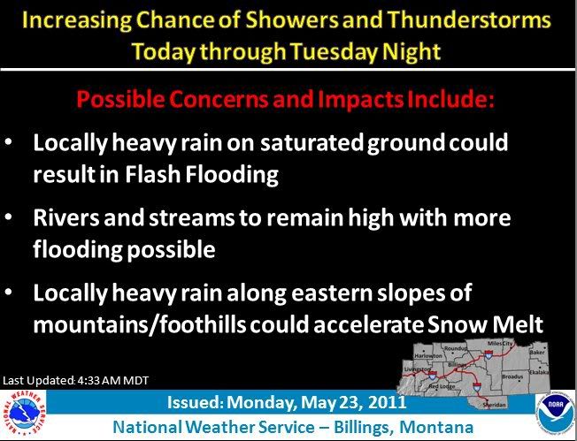
FLOOD STATEMENT
NATIONAL WEATHER SERVICE BILLINGS MT
541 AM MDT MON MAY 23 2011
...FLOOD WARNINGS CONTINUE FOR THE FOLLOWING LOCATIONS IN SOUTH
CENTRAL AND SOUTHEAST MONTANA...
TONGUE RIVER NEAR MILES CITY
YELLOWSTONE RIVER NEAR FORSYTH
YELLOWSTONE RIVER NEAR MILES CITY
LITTLE BIGHORN RIVER NEAR HARDIN
.HEAVY RAIN OF 2 TO 5 INCHES ACROSS A LARGE PART OF THE AREA HAS
CAUSED SIGNIFICANT RISES ON SEVERAL RIVERS. SMALL STREAMS AND CREEKS
WERE ALSO FLOODING ACROSS A LARGE PART OF THE AREA AND FEEDING INTO
THE MAIN STEM RIVERS...CAUSING THEM TO FLOOD. RAIN EXPECTED OVER THE
NEXT FEW DAYS WILL LIKELY EXASPERATE FLOODING.
PRECAUTIONARY/PREPAREDNESS ACTIONS...
THE LATEST STAGES AND FORECASTS FOR RIVERS AND STREAMS CAN BE FOUND
AT OUR WEB PAGE: HTTP://WATER.WEATHER.GOV
&&
MTC017-241741-
/O.CON.KBYZ.FL.W.0005.000000T0000Z-110527T1800Z/
/MILM8.1.ER.110522T1624Z.110524T0000Z.110527T0600Z. NO/
541 AM MDT MON MAY 23 2011
THE FLOOD WARNING CONTINUES FOR
THE YELLOWSTONE RIVER AT MILES CITY.
* UNTIL FRIDAY AFTERNOON...OR UNTIL THE WARNING IS CANCELLED.
* AT 5 AM MONDAY THE STAGE WAS 14.2 FEET.
* FLOOD STAGE IS 13.0 FEET.
* FLOODING IS OCCURRING AND WILL CONTINUE UNTIL LATE WEEK.
* FORECAST...THE RIVER WILL CREST NEAR 16.0 FEET AROUND 6 PM MONDAY.
THE RIVER WILL FALL BELOW FLOOD STAGE BY FRIDAY.
* OTHER SMALL STREAMS AND CREEKS...PUMPKIN CREEK AND POWDER RIVER AT
LOCATE WILL CONTINUE FLOODING INTO MONDAY AND SHOULD FALL BACK
WITHIN THEIR BANKS MONDAY NIGHT. MANY COUNTY ROADS ARE EXTREMELY
DIFFICULT TO NEARLY IMPOSSIBLE TO TRAVEL ON DUE TO FLOODING AND THIS
IS EXPECTED TO CONTINUE INTO EARLY WEEK.
&&
FLOOD OBSERVED FORECAST 12 PM
LOCATION STAGE STAGE DAY TIME TUE WED THU
YELLOWSTONE RIVER
MILES CITY 13.0 14.2 MON 05 AM 15.5 14.0 12.2
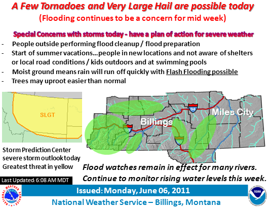
bulletin - eas activation requested
flash flood warning
national weather service billings mt
352 pm mdt tue may 24 2011
the national weather service in billings has issued a
* flash flood warning for...
Western big horn county in south central montana...
South central yellowstone county in south central montana...
* until 645 pm mdt
* at 342 pm mdt...national weather service doppler radar indicated
flash flooding from thunderstorms over the warned area. Radar
was indicating rainfall amounts of up to an inch in one hour. The
heavy rainfall will impact pryor creek in yellowstone county
and streams draining into the st. Xavier area in big horn county.
* the storms producing flash flooding will otherwise remain over
mainly rural areas of the indicated county.
Precautionary/preparedness actions...
Most flood deaths occur in automobiles. Never drive your vehicle into
areas where the water covers the roadway. Flood waters are usually
deeper than they appear. Just one foot of flowing water is powerful
enough to sweep vehicles off the road. When encountering flooded
roads make the smart choice...turn around...dont drown.
Notes: Location of reports are referenced from city center.
...big horn county...
***** storm total rainfall reports ***** time rainfall
wolf mountain raws (lodge grass 9.3 e) 9 am thu 10.90 in
pryor mountain raws (pryor 5.8 sse) 9 am thu 7.76 in
bighorn mountain raws (wyola 24.5 w) 9 am thu 6.73 in
fort smith 0.8 nw 8 am thu 6.56 in
lodge grass 4.5 n 7 am thu 5.80 in
little bighorn raws (crow agency 2.2 sse) 8 am thu 5.62 in
lame deer 7.9 wsw 8 am wed 4.44 in
hardin 6.7 n 6 am thu 4.28 in
hardin 0.2 ene 4 pm wed 4.00 in
hardin 0.6 ene 6 am thu 3.95 in
hardin 0.4 sw 8 am thu 3.26 in
...carbon county...
***** storm total rainfall reports ***** time rainfall
cole creek snotel (7850 ft) 1 am thu 7.40 in
red lodge 2.0 w 5 pm wed 7.27 in
red lodge 8.4 w 8 am thu 6.42 in
red lodge 1.2 s 7 am thu 6.17 in
red lodge 4 n 7 am thu 5.76 in
roberts 5.9 nnw 7 am thu 5.43 in
burnt mountain snotel (5880 ft) 1 am thu 5.40 in
edgar 0.2 nnw 12 am wed 5.39 in
joliet 2.2 wsw 7 am thu 5.23 in
red lodge 2.3 ne 12 pm thu 5.22 in
wild horse raws (warren 18.0 ene) 8 am thu 4.83 in
bridger 4.0 ssw 12 am wed 4.50 in
bridger 2.3 n 7 am wed 4.08 in
deer mountain raws (belfry 4.4 ne) 8 am thu 3.19 in
hillsboro raws (warren 21.7 e) 8 am wed 2.21 in
...carter county...
***** storm total rainfall reports ***** time rainfall
ridge 3.8 ne 7 am thu 7.22 in
ekalaka 0.2 ene 4 pm tue 6.54 in
alzada 14.2 w 9 am sun 6.00 in
ridgeway 3.5 nne 9 am sun 5.50 in
ridgway 2.7 ene 1 pm wed 5.27 in
alzada 20.7 nw 8 am tue 4.17 in
...custer county...
***** storm total rainfall reports ***** time rainfall
volborg 12 pm wed 6.85 in
miles city 8.7 e 7 am thu 6.55 in
miles city 0.3 sse 1 am mon 6.32 in
miles city 19.5 nw 8 pm sun 6.05 in
ismay 3.4 ne 12 am sun 5.13 in
mizpah 17.0 sw 6 am mon 5.00 in
miles city 0.3 nw 8 am wed 4.98 in
volborg 31.2 e 6 pm tue 4.89 in
ismay 27.6 wsw 7 am wed 4.80 in
knowlton raws (knowlton 3.7 se) 8 am wed 4.59 in
mizpah 3.1 nnw 12 pm wed 4.57 in
miles city 2.6 wnw 11 pm wed 4.43 in
...fallon county...
***** storm total rainfall reports ***** time rainfall
webster 6.9 ese 7 am wed 5.04 in
plevna 0.4 ssw 7 am wed 4.78 in
plevna 0.2 nne 6 pm wed 4.24 in
baker 0.2 ssw 8 am wed 3.50 in
cannonball creek raws (baker 12.9 ne) 8 am wed 3.35 in
...golden valley county...
***** storm total rainfall reports ***** time rainfall
ryegate 9.7 sw 7 am wed 7.41 in
ryegate 5.4 s 6 am wed 5.15 in
ryegate 0.3 e 7 am thu 4.98 in
ryegate 0.1 nne 5 pm wed 4.70 in
ryegate 16.8 nnw 7 am thu 3.59 in
lavina 5.8 sse 11 am tue 2.50 in
...musselshell county...
***** storm total rainfall reports ***** time rainfall
roundup 8.1 se 6 am thu 6.80 in
roundup 8.8 s 7 am thu 6.58 in
lavina 9.5 ese 10 am mon 5.50 in
roundup 15.5 sw 10 am wed 5.35 in
klein 0.6 s 7 am thu 4.96 in
roundup 12.7 sw 7 am thu 4.37 in
roundup 4.3 sse 9 am thu 4.00 in
melstone 0.1 ne 7 am wed 3.96 in
roundup 0.5 s 5 pm wed 3.75 in
horse thief raws (roundup 6.5 wsw) 3 pm wed 3.73 in
roundup 6.2 ene 7 am thu 3.54 in
roundup 8.6 nne 6 am wed 3.25 in
roundup 10.9 nne 7 am wed 2.98 in
...park county...
***** storm total rainfall reports ***** time rainfall
mcleod 12.8 sw 7 am wed 5.37 in
livingston 6.6 ese 7 am thu 4.76 in
south fork shields snotel (8100 ft) 1 am thu 3.80 in
livingston 5.8 ene (airport) 8 am thu 3.50 in
clyde park 12.8 ese 12 am wed 3.30 in
porcupine snotel (6500 ft) 1 am wed 3.00 in
livingston 2.3 ssw 5 am thu 2.75 in
livingston 0.4 ssw 6 am thu 2.73 in
monument peak snotel (8850 ft) 1 am thu 2.40 in
box canyon snotel (6700 ft) 1 am thu 2.20 in
fisher creek snotel (9100 ft) 1 am wed 2.00 in
chico hot springs 17.1 ese 6 am wed 1.98 in
gardiner 0.1 e 6 pm wed 1.39 in
white mill snotel (8700 ft) 1 am thu 1.20 in
cooke city 1.0 w 6 pm wed 1.18 in
wilsall 0.3 nw 7 am wed 1.02 in
...powder river county...
***** storm total rainfall reports ***** time rainfall
ashland 11.9 e 7 am wed 6.61 in
broadus 18.8 nnw 7 pm wed 6.47 in
ashland 9.7 ese 6 am wed 6.34 in
broadus 9.8 w 7 am wed 5.55 in
bradshaw creek raws (moorhead 3.8 wsw) 8 am thu 4.65 in
broadus 0.1 ene 5 pm wed 4.62 in
biddle 8.2 wsw 6 pm tue 4.53 in
boyes 1.7 nne 7 am thu 4.36 in
broadus 12.3 sse 7 am thu 4.31 in
fort howes raws (otter 6.7 nne) 8 am thu 3.86 in
broadus 12.6 sw 7 am tue 3.79 in
moorhead 9.5 ne 6 pm wed 3.34 in
...rosebud county...
***** storm total rainfall reports ***** time rainfall
badger peak raws (lame deer 8.1 ene) 9 am thu 6.58 in
rma portable raws (lame deer 3.9 se) 9 am wed 6.03 in
colstrip 1.0 n 8 am thu 5.96 in
lame deer 0.3 nnw 8 am thu 5.22 in
forsyth 1.5 ene 7 am wed 4.85 in
forsyth 0.4 nne 4 am tue 4.41 in
melstone 5.7 e 8 am thu 3.58 in
sumatra 11.3 wsw 7 am thu 3.36 in
...stillwater county...
***** storm total rainfall reports ***** time rainfall
absarokee 0.6 s 8 am thu 6.71 in
absarokee 0.1 ene 7 am thu 6.33 in
fishtail raws (fishtail 3.1 w) 8 am wed 5.68 in
nye 0.1 se 1 pm wed 5.45 in
custer #1 portable raws (nye 6.5 nw) 9 am wed 5.31 in
columbus 7.5 e 7 am thu 5.03 in
reed point 5 se 6 am thu 4.94 in
columbus 7.2 e 7 am thu 4.74 in
main boulder raws (mcleod 23.2 ssw) 3 pm wed 4.38 in
rapelje 0.8 s 6 pm wed 4.29 in
columbus 3.2 wsw 5 am thu 4.00 in
columbus 4.8 nnw 8 am thu 3.50 in
columbus 0.9 nw 6 pm wed 3.43 in
park city 0.5 s 7 am wed 3.11 in
fishtail 18.1 sw 4 pm wed 2.75 in
...sweet grass county...
***** storm total rainfall reports ***** time rainfall
derby mountain raws (greycliff 12.8 ssw) 4 pm wed 7.04 in
east boulder mine snotel (6335 ft) 1 am thu 6.60 in
mcleod 0.1 nw 8 am wed 6.42 in
placer basin snotel (8830 ft) 1 am thu 6.40 in
big timber 0.3 ese 7 am thu 4.83 in
big timber 0.5 e 8 am thu 4.77 in
mcleod 19.6 ssw 8 am wed 3.89 in
big timber 11.5 s 7 am tue 3.47 in
reed point 8.6 wsw 7 am tue 3.09 in
...treasure county...
***** storm total rainfall reports ***** time rainfall
hysham 25.0 sse 2 pm wed 5.18 in
hysham 4.4 ese 7 am mon 5.16 in
hysham 0.2 nnw 5 pm wed 4.44 in
hysham 8.0 w 7 am thu 3.80 in
hysham 0.4 ese 7 am wed 3.67 in
...wheatland county...
***** storm total rainfall reports ***** time rainfall
twodot 6.5 s 10 am wed 5.38 in
kilo raws (harlowton 1.7 ene) 3 pm wed 3.83 in
judith gap 13.1 e 7 am thu 3.19 in
...yellowstone county...
***** storm total rainfall reports ***** time rainfall
billings heights southwest (2.2 nne) 6 am thu 6.93 in
soda springs raws (lockwood 6.0 s) 3 pm thu 6.22 in
billings 9.5 ene 7 am thu 6.02 in
steamboat raws (pompeys pillar 19.8 nnw) 3 pm wed 5.84 in
billings airport (2.6 nw) 11 pm wed 5.68 in
billings 1.0 nw 8 am thu 5.61 in
billings heights 5.3 ne 7 am thu 4.78 in
billings 7.1 w 7 am thu 4.70 in
billings heights 4.5 ne 8 am thu 4.70 in
ballantine 0.1 ene 6 am wed 4.69 in
billings southside (1.4 se) 3 pm wed 4.57 in
billings briarwood 5.1 s 7 am thu 4.28 in
pompeys pillar 15.9 nnw 7 am wed 4.27 in
huntley 3.6 ene 8 am wed 4.08 in
billings southwest (3.9 sw) 11 pm wed 3.93 in
billings 7.4 sw 8 am thu 3.40 in
...sheridan county wyoming...
***** storm total rainfall reports ***** time rainfall
parkman 8.6 w 7 am thu 7.61 in
tie creek snotel (6870 ft) 1 am thu 6.80 in
sucker creek snotel (8880 ft) 1 am thu 6.60 in
story 0.6 wnw 6 am thu 6.59 in
burgess junction 0.3 nnw 5 am thu 6.32 in
burgess junction snotel (7880 ft) 1 am thu 5.80 in
dayton 0.1 w 6 am wed 5.78 in
sheridan 1.6 sse 8 am wed 5.64 in
dayton 0.2 nne 7 am wed 5.43 in
big goose snotel (7990 ft) 1 am thu 5.40 in
ranchester 1.3 ese 7 am thu 5.25 in
big horn 0.7 wsw 8 am thu 5.12 in
wyarno 9.5 nne 7 am thu 5.02 in
big horn 0.8 w 8 am thu 4.86 in
banner 3.5 e 7 am wed 4.53 in
sheridan 1.7 nw 8 am thu 4.51 in
burgess raws (burgess junction 1.4 nw) 9 am thu 4.36 in
sheridan 12.9 ese 7 am mon 4.20 in
sheridan 3.4 ssw 7 am thu 4.11 in
dome lake snotel (8880 ft) 1 am thu 4.10 in
boyd ridge raws (burgess junction 15.1 nw) 4 pm thu 4.05 in
sheridan 1.0 n 7 am thu 4.02 in
sheridan 13.8 nne 7 am thu 4.02 in
sheridan 1.1 ssw 8 am wed 3.56 in
sheridan 2.2 ssw 11 pm wed 3.45 in
sheridan 8.1 nne 8 am wed 3.43 in
clearmont 5.1 nne 7 am mon 2.51 in
clearmont 5.4 sw 10 pm wed 2.50 in
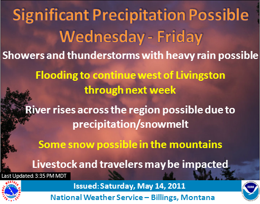
Flood watch
national weather service billings mt
359 am mdt sat may 28 2011
...heavy rain possible sunday through memorial day...
.another strong storm system will move into the area for the
memorial day holiday weekend. This storm will spread rain across
the entire area sunday through memorial day. Some of the rain
will be locally heavy. Additional heavy rain would cause already
flooded and swollen rivers to remain high and continue the flood
threat into next week.
Mtc003-009-011-017-025-037-065-067-075-087-095-097-103-107-111-
wyc033-291000-
/o.con.kbyz.fa.a.0004.110529t1200z-110531t1200z/
/00000.0.er.000000t0000z.000000t0000z.000000t0000z. oo/
big horn-carbon-carter-custer-fallon-golden valley-musselshell-
park-powder river-rosebud-stillwater-sweet grass-treasure-
wheatland-yellowstone-sheridan-
including the cities of...hardin...crow agency...red lodge...
Bridger...joliet...ekalaka...miles city...baker...ryegate...
Lavina...roundup...livingston...broadus...colstrip ...lame deer...
Forsyth...columbus...absarokee...big timber...hysham...
Harlowton...billings...sheridan
359 am mdt sat may 28 2011
...flood watch remains in effect from sunday morning through late
monday night...
The flood watch continues for
* portions of montana and north central wyoming...including the
following counties...in montana...big horn...carbon...
Carter...custer...fallon...golden valley...musselshell...
Park...powder river...rosebud...stillwater...sweet grass...
Treasure...wheatland and yellowstone. In north central
wyoming...sheridan.
* from sunday morning through late monday night
* widespread showers with embedded thunderstorms will move into
the area sunday. The precipitation will persist into memorial
day. Some of the rain will be locally heavy and rainfall
amounts of 1 to 3 inches will be common by the time the rain
ends monday night.
* many area streams and creeks...along with some main stem
rivers were already flooding...or running very high. A
saturated ground from all the rain over the last three weeks
will cause any additional rain to run right off into those
swollen rivers. This runoff will cause quick rises again and
exacerbate the flooding across the area.
* for the beartooth/absaroka and big horn mountains...the flood
threat is primarily below 7 thousand feet. Snow is expected
above 7 thousand feet for this event.
Precautionary/preparedness actions...
A flood watch means there is a potential for flooding based on
current forecasts.
You should monitor later forecasts and be alert for possible
flood warnings. Those living in areas prone to flooding should be
prepared to take action should flooding develop.
Bulletin - Eas Activation Requested
Flood Warning
National Weather Service Billings MT
1243 PM MDT Sun May 29 2011
Big Horn MT-
1243 PM MDT Sun May 29 2011
The National Weather Service In Billings Has Issued A
* Flood Warning For Small Streams In,
Big Horn County In South Central Montana,
This Includes The City Of Hardin,
* Until 100 AM MDT Wednesday
* Radar Indicates That Periods Of Moderate To Heavy Rain In The
Foothills Of The Pryor And Northern Big Horn Mountains Has Resulted
In Up To An Inch Of Rainfall Since Saturday Evening. Persistent East
To Northeast Winds Will Continue To Upslope Into These Foothills
Locations Resulting In Rainfall Rates Of A Tenth To Two Tenths Of An
Inch Per Hour, Producing Rainfall Totals Of 2 To 4 Inches By The
Time Precipitation Tapers Off Tuesday. With Already Saturated Ground
This Precipitation Will Quickly Run Off Into Already Full Streams
And Creeks Producing Flooding In Some Areas.
* This Flood Warning Includes But Is Not Limited To Pryor
Creek, Fly Creek, Beauvais Creek, Two Leggins Creek And Rotten
Grass Creek.
* Snowfall In The Higher Foothills Will Limit Flooding Potential
Above 5000 Feet Until Warmer Temperatures Arrive Later In The Week.
A Flood Warning Means That Flooding Is Imminent Or Has Been Reported.
Stream Rises Will Be Slow And Flash Flooding Is Not Expected.
However, All Interested Parties Should Take Necessary Precautions
Immediately.
Precautionary/Preparedness Actions,
Most Flood Deaths Occur In Automobiles. Never Drive Your Vehicle Into
Areas Where The Water Covers The Roadway. Flood Waters Are Usually
Deeper Than They Appear. Just One Foot Of Flowing Water Is Powerful
Enough To Sweep Vehicles Off The Road. When Encountering Flooded
Roads Make The Smart Choice, Turn Around, Dont Drown.
To Report Flooding, Have The Nearest Law Enforcement Agency Relay
Your Report To The National Weather Service Forecast Office.
Please register to post and access all features of our very popular forum. It is free and quick. Over $68,000 in prizes has already been given out to active posters on our forum. Additional giveaways are planned.
Detailed information about all U.S. cities, counties, and zip codes on our site: City-data.com.

 Please register to participate in our discussions with 2 million other members - it's free and quick! Some forums can only be seen by registered members. After you create your account, you'll be able to customize options and access all our 15,000 new posts/day with fewer ads.