Please register to participate in our discussions with 2 million other members - it's free and quick! Some forums can only be seen by registered members. After you create your account, you'll be able to customize options and access all our 15,000 new posts/day with fewer ads.
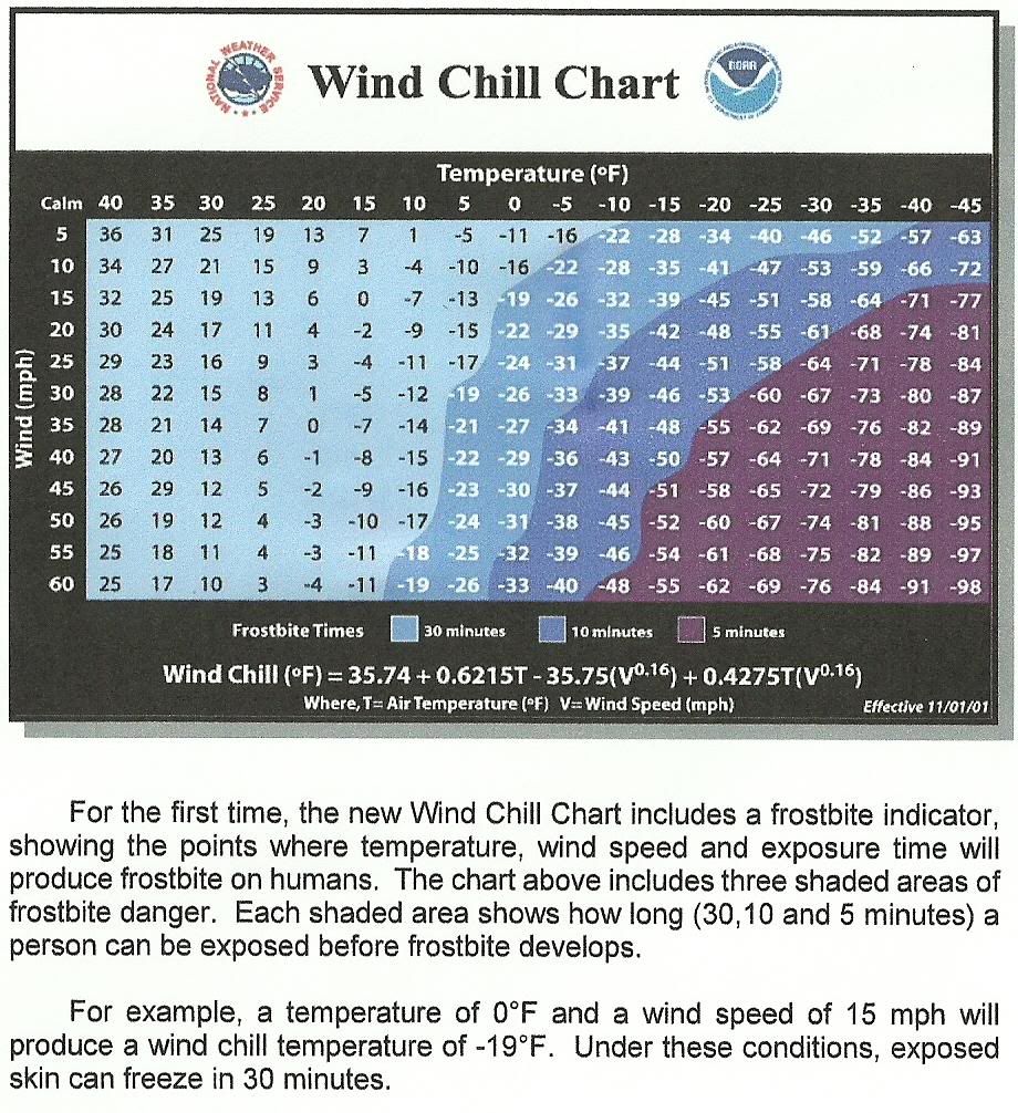
What is Wind Chill?
It is the temperature it "Feels like" outside and is based on the rate of heat loss from exposed skin caused by the effects of wind and cold. As the wind increases, the body is cooled at a faster rate causing the skin temperature to drop. Wind Chill does not impact inanimate objects like car radiators and exposed water pipes, because these objects cannot cool below actual air temperature.
What is Frostbite?
Frostbite is an injury to the body caused by freezing body tissue. The most susceptible parts of the body are the extremities such as fingers, toes, ear lobes, or the tip of the nose. Symptoms include loss of feeling in the extremity and a white or pale appearance. Medical attentions is needed immediately for frostbite. The area should be SLOWLY re-warmed.
What is Hypothermia?
Hypothermia is abnormally low body temperature (below 95 degrees Fahrenheit). Warning signs include uncontrollable shivering, memory loss, disorientation, incoherence, slurred speech, drowsiness, and apparent exhaustion. Medical attention is needed immediately. If it is not available, begin warming the body SLOWLY.
Tips on how to dress during cold weather.
- Wear layers of loose-fitting, lightweight, warm clothing. Trapped air between the layers will insulate you. Outer garments should be tightly woven, water repellent, and hooded.
- Wear a hat, because 40% of your body heat can be lost from your head.
- Cover your mouth to protect your lungs from extreme cold.
- Mittens, snug at the wrist, are better than gloves.
- Try to stay dry and out of the wind.
Advisory
(Abbrev. ADVY)- Highlights special weather conditions that are less serious than a warning. They are for events that may cause significant inconvenience, and if caution is not exercised, it could lead to situations that may threaten life and/or property.
Watch
A watch is used when the risk of a hazardous weather or hydrologic event has increased significantly, but its occurrence, location, and/or timing is still uncertain. It is intended to provide enough lead time so that those who need to set their plans in motion can do so.
Warning
A warning is issued when a hazardous weather or hydrologic event is occurring, is imminent, or has a very high probability of occurring. A warning is used for conditions posing a threat to life or property.
Storm
Any disturbed state of the atmosphere, especially affecting the Earth's surface, and strongly implying destructive and otherwise unpleasant weather. Storms range in scale from tornadoes and thunderstorms to tropical cyclones to synoptic-scale extratropical cyclones.
Blizzard
(abbrev. BLZD)- A blizzard means that the following conditions are expected to prevail for a period of 3 hours or longer:
Sustained wind or frequent gusts to 35 miles an hour or greater; and
Considerable falling and/or blowing snow (i.e., reducing visibility frequently to less than ¼ mile)
Urgent - winter weather message
national weather service great falls mt
541 am mdt wed oct 3 2012
mtz009-031800-
/o.upg.ktfx.ww.y.0032.000000t0000z-121004t0000z/
/o.new.ktfx.ws.w.0016.121003t1141z-121003t1800z/
northern rocky mountain front-
including the following locations...browning...marias pass...
Logan pass
541 am mdt wed oct 3 2012
...winter storm warning in effect until noon mdt today...
The national weather service in great falls has issued a winter
storm warning for heavy snow which is in effect until noon mdt
today. The winter weather advisory is no longer in effect.
* timing and main impact: Snow...heavy at times... Will continue
through the morning. Snow will diminish by this afternoon.
* snow accumulations: 6 to 10 inches are possible.
* winds and visibility: North winds 10 to 20 mph with gusts to
30 mph will cause areas of poor visibilities.
* other impacts: Travel through mountain passes may become
difficult with snow or slush covered roads. Outdoor
enthusiasts should also be prepared for winter conditions...
Especially at higher elevations.
A winter storm warning for heavy snow means severe winter weather
conditions are expected or occurring. Significant amounts of snow
are forecast that will make travel dangerous. Only travel in an
emergency. If you must...keep an extra flashlight...food...and
water in your vehicle in case of an emergency.
For specific road and travel conditions in montana...dial 5 1 1.
Winter Weather Advisory, North Western Montana, 10-3-12
Urgent - winter weather message
national weather service great falls mt
541 am mdt wed oct 3 2012
mtz011>013-044>047-049-051-031800-
/o.con.ktfx.ww.y.0032.000000t0000z-121004t0000z/
hill-cascade-chouteau-toole-liberty-eastern pondera-blaine-
eastern teton-fergus-
including the following locations...kings hill pass...fairfield...
Lewistown...lewistown divide
541 am mdt wed oct 3 2012
...winter weather advisory remains in effect until 6 pm mdt this
evening for elevations above 3500 feet...
A winter weather advisory for elevations above 3500 feet remains
in effect until 6 pm mdt this evening.
* timing and main impact: Rain and snow will continue through
the morning and should taper off by afternoon.
* snow accumulations: 1 to 3 inches are likely below 3500 feet
and 3 to 6 inches are possible above 3500 feet.
* winds and visibility: North winds 10 to 20 mph with gusts to
30 mph will cause areas of poor visibilities.
* elevations: For elevations above 3500 feet.
* locations affected include: Fairfield...kings hill pass...
Lewistown...lewistown divide
precautionary/preparedness actions...
A winter weather advisory for snow means that periods of snow
will cause primarily travel difficulties. Be prepared for snow
covered roads and limited visibilities...and use caution while
driving.
For specific road and travel conditions in montana...dial 5 1 1.
Advice from the National Weather Service out of Billings
The shelter and warmth of a vehicle can lead to a false sense of security during
winter travel. By using the following safety rules, you can help protect
your family from the harshness of winter.
Protect Yourself and Your Family
Check the latest forecast and road report before you set out. Call 511 for travel information in Montana.
Dress for the outdoor conditions, not for the warmth of the vehicle.
Have your vehicle winterized...give it a checkup.
Include a winter survival kit. Try not to travel alone, and stay on major roads. Let someone know the
route you are taking and when you plan to arrive.
Keep your gas tank full.
If you become stranded, stay with the vehicle. Do not try to walk away from the vehicle unless you can
see a place of safety at a reasonable distance.
If stranded, run the motor for about 10 minutes each hour for heat. Open a window slightly for fresh air.
Make sure the exhaust pipe is not blocked.
If stranded, tie a brightly colored cloth to the antenna, or let it hang from a rolled-up window on the side
of the vehicle nearest the road. Turn on the dome light at night when the motor is running. This will
make your vehicle more visible to rescuers.
If stranded, don’t allow all occupants sleep at the same time. Be sure someone stays awake! If you are
alone, stay awake! Move around, clap your hands, rub your legs, and stretch.
High Wind Warning, North Eastern Montana, 10-15-12
Urgent - weather message
national weather service great falls mt
239 pm mdt mon oct 15 2012
mtz010-012-014-044>046-049-160600-
/o.con.ktfx.hw.w.0037.121016t0300z-121017t0600z/
eastern glacier-cascade-central and southern lewis and clark-
toole-liberty-eastern pondera-eastern teton-
including the following locations...cut bank...great falls...
Kings hill pass...flesher pass...helena...lincoln...
Macdonald pass...rogers pass...shelby...chester...conrad...
Fairfield
239 pm mdt mon oct 15 2012
...high wind warning remains in effect from 9 pm this evening to
midnight mdt tuesday night...
A high wind warning remains in effect from 9 pm this evening to
midnight mdt tuesday night.
* timing and main impact: Southwest to west winds will increase
tonight and become strong by tuesday morning. The period of
strongest winds is expected to occur tuesday afternoon. Winds
will gradually diminish tuesday night. The strong winds could create
difficult driving conditions for high profile vehicles.
* winds: Sustained west winds of 35 to 45 mph...with gusts near
65 mph are expected.
* other impacts: Some power outages will be possible.
A high wind warning means a hazardous high wind event is expected
or occurring. Sustained wind speeds of at least 40 mph or gusts
of 58 mph or more can lead to property damage.
Urgent - weather message
national weather service billings mt
607 am mdt wed oct 17 2012
...expect very strong winds to redevelop by midday...
.another surge of winds is expected later this morning as the jet
stream lines up with an unstable low level atmosphere and a
developing low pressure system over the dakotas. Winds will be
persistently strong today before decreasing during the evening
hours.
Mtz031>033-036-037-058-180600-
/o.con.kbyz.hw.w.0015.000000t0000z-121018t0600z/
northern rosebud-custer-fallon-powder river-carter-
southern rosebud-
including the cities of...colstrip...forsyth...miles city...
Baker...broadus...ekalaka...lame deer
607 am mdt wed oct 17 2012
...high wind warning remains in effect until midnight mdt
tonight...
* timing...already gusty winds are expected to increase later
this morning becoming very strong around noon. Winds will be
persistent throughout the afternoon before decreasing later this
evening.
* overnight reports...a wind gust of 63 mph occurred at miles city
and a gust of 58 occurred at baker. Large tree limbs were
reported downed in miles city.
* impacts...dangerous cross winds can be expected on area roads.
Property damage may occur especially as poorly secured items
become projectiles.
* winds...expect northwest winds of 35 to 50 mph with gusts to 65
mph possible.
Precautionary/preparedness actions...
Winds of these magnitudes can cause property damage without extra
precautions. Motorists in high profile vehicles should use
caution until the winds subside.
Hazardous Weather Outlook: Winter storm conditions are possible in the next 7 days. Stay tuned to the National Weather Service and local media for updates.
Watch: The potential exists for hazardous winter weather to occur within the next 12 to 48 hours but the exact location and timing is not known. Actions can be taken to stock up on needed supplies such as water and food and to make sure you have a plan to protect pets and livestock.
Warning: Hazardous winter weather either is occurring or will be shortly. Immediate action should be taken to protect yourself as well as your pets and livestock. Only travel outside of your home if you absolutely have to.
Advisory: Winter weather conditions are expected to cause significant inconveniences and may be hazardous. If you are cautious, these situations should not be life threatening.
Stay tuned to these products throughout the winter storm for specific details on impacts expected.
Terminology
Blizzard: Winds of 35 mph or more with snow and blowing snow reducing visibility to less than 1/4 mile for at least 3 hours.
Winter Storm: A variety of winter conditions may be possible including heavy snow, blizzard conditions, significant accumulations of freezing rain or sleet and dangerous wind chills.
Wind Chill: A measure of how cold the atmosphere feels, taking not just actual temperature into account, but also wind, which can make the air considerably colder.
Ice Storm: A type of winter storm characterized by significant amounts of freezing rain. Heavy accumulations of ice can bring down trees and topple utility poles.
Conditions are favorable for hazardous winter weather conditions including heavy snow, blizzard conditions, or significant accumulations of freezing rain or sleet in the next 12 to 48 hours. It may also include wind chills if they are expected with the above listed events.
Blizzard Watch
Conditions are favorable for blizzard conditions in the next 12 to 48 hours.
Wind Chill Watch
Conditions are favorable for dangerous wind chills in the next 12 to 48 hours.
Winter Weather Warnings
Winter Storm Warning
Any one or a combination of the following (the elevations are generalized in this criteria, some areas may have more specific criteria):
Eastern Montana and Western Montana Valleys: 6 inches or more in 12 hours or 8 inches or more in 24 hours.
Mountain Areas: 8 inches or more in 12 hours, 12 inches or more in 24 hours. Sustained winds of less than 34 mph causing blowing snow (with or without snowfall occurring) reducing visibility to more than a 1/4 mile for 3 hours or more.
-Ice accumulations under a 1/4" that last for three hours or more and occurs on 50% of a significant public use area on roadways and sidewalks.
-Sleet accumulations of a 1/2" or more.
-Wind chills of ≤ -40 degrees (east of the divide) or ≤ -20 degrees (west of the divide) with winds of ≥ 10 mph occurring with any of the above criteria.
Blizzard Warning
Sustained or frequent gusts of 35 mph or more, frequent visibilities of ≤ 1/4 mile, falling and/or blowing snow for 3 hours or more.
Ice Storm Warning
Issued when significant and damaging accumulations of ice are expected, generally a 1/4" accumulation or more.
Wind Chill Warning
East of the Divide: Wind chills of ≤ -40 degrees with winds ≥ 10 mph, no precipitation occurring.
West of the Divide: Wind chills of ≤ -20 degrees with winds ≥ 10 mph, no precipitation occurring.
Winter Weather Advisories
Winter Weather Advisory
Any one or a combination of the following:
-2 to 5 inches of snow in 12 hours below 6000 feet. Some mountainous areas may have other criteria, generally 4-7 inches.
-Wind driven snow that occasionally reduces visibilities down to a 1/4 mile.
-Wind chill advisory criteria along with 2-5 inches of snow and/or blowing snow reducing visibility down to a 1/4 mile, or 4-7 inches of snow in mountainous areas.
-Sleet accumulations of less than a 1/2".
-An event that transitions to or from freezing rain into any of the above criteria.
Wind Chill Advisory
East of the Divide: Wind chills of -20 degrees to -39 degrees with winds of ≥ 10 mph, no precipitation occurring.
West of the Divide: Wind chills of -10 degrees to -19 degrees with winds of ≥ 10 mph, no precipitation occurring.
Freezing Rain Advisory
Glazing of freezing drizzle or freezing rain for a few hours with accumulations of less than 1/4 inch. It generally covers less than 50% of the area.
Every year, winter claims dozens of lives and causes millions of dollars in damage across the United States. A significant higher number of injuries occur; seventy percent of which are the result of vehicle accidents. Just in Montana since 2000, 14 people have lost their lives in extreme winter weather conditions with many more injuries. Cold weather exposure and automobile accidents are the main causes of winter weather related deaths in Montana. Livestock injuries and deaths can also be quite common during the more hazardous events. The following are some of the causes of both direct and indirect deaths and injuries in Montana as well as causes of damage:
•Extreme wind chill or extreme cold (within a home and outside)
•Vehicle accidents
•Avalanches
•Leaving a shelter such as a home or vehicle
•Carbon monoxide poisoning from an incorrectly set up generator or vehicle exhaust obstructed by snow
•Collapse of structures from heavy snow loading
•Fallen tree branches due to heavy snow
Be Prepared:
At Home and Work
The primary concerns during a winter storm are loss of heat, power and telephone service and a shortage of supplies if storm conditions continue for more than a day. Have these items available:
•Flashlight and extra batteries
•Battery powered NOAA Weather Radio
•Extra food and water
•Extra medicine and baby items
•First-aid supplies
•Emergency heat source
•Heating fuel
•Fire extinguisher
•Smoke alarm - Test once a month
•Make sure pets and livestock have plenty of food, water and shelter
In Vehicles
Plan your travel and check the latest weather reports to avoid the storm. Fully check and winterize your vehicle before the winter season begins. Carry a winter storm survival kit with these items:
•Mobile phone and charger
•Blankets/sleeping bags
•Flashlight with extra batteries
•First-aid kit
•Extra clothing
•Shovel
•Windshield scraper and brush
•Tool kit
•Tow rope
•Battery booster cables
•Water container
•Compass and road maps
•High-calorie, non-perishable food
•Small can and waterproof matches to melt snow for drinking water
•Knife
On the Farm/Pets
Take these steps before the storm hits to ensure the safety of your pets and animals:
•Move animals to sheltered areas.
•Haul extra feed to nearby feeding areas.
•Have water available. Most animals die from dehydration in winter storms.
•Make sure pets have plenty of food, water and shelter.
Caught in a storm:
Outside
Find Shelter: Try to stay dry. Cover all exposed body parts.
If No Shelter: Build a lean-to, windbreak or snow cave for protection from the wind. Build a fire for heat and to attract attention. Place rocks around the fire to absorb and reflect heat.
Stay Hydrated: Melt snow for drinking water. Avoid eating snow. Eating snow will lower your body temperature
In a Vehicle
Stay In Vehicle: You will become quickly disoriented in wind-driven snow and cold. Run the motor about 10 minutes each hour for heat. Open the window a little for fresh air to avoid carbon monoxide poisoning. Make sure the exhaust pipe is not blocked.
Be Visible To Rescuers: Turn on the dome light at night when running the engine. Tie a colored cloth, preferably red, to your antenna or door. After snow stops falling, raise the hood to indicate you need help.
Exercise: From time to time, move arms, legs, fingers and toes vigorously to keep blood circulating and to keep warm.
Inside
Stay Inside: When using alternate heat from a fireplace, wood stove, space heater, etc., use fire safeguards and properly ventilate.
No Heat: Close off unneeded rooms. Cover windows at night. Eat and drink plenty. Food provides the body with energy for producing its own heat. Keep the body replenished with fluids to prevent dehydration. Wear layers of loose-fitting, lightweight, warm clothing. Remove layers to avoid overheating, perspiration and subsequent chill.
Montana, Winter Weather Awareness Week, Part 3 (Final)
Weather Sources:
Internet / Social Media / TV / Radio / Wireless Sources
Internet: The National Weather Service's webpage at http://weather.gov allows you a fast and easy look at where the hazards are occurring for the current day. To find out information for your local area, just click on the map in your general area.
Facebook: Follow us on Facebook for updates on the latest weather concerns, climate information and other interesting tidbits.
•Billings
•Glasgow
•Great Falls
•Missoula
Twitter: Follow us on Twitter for updates on the latest weather concerns, climate information and other interesting tidbits.
•Billings
•Glasgow
•Great Falls
•Missoula
Broadcast TV and Radio Stations: Most local radio and television stations across the state automatically receive hazardous watches and warnings and help disseminate that information over the air. They have local knowledge and want to be able to provide their viewers and listeners with the best information they can.
Wireless / Cell Phone technologies: Many cell phone providers are including an option of getting warnings on your cell phone through text messaging or other means. Check with your provider to see if they offer a service like this. There are also some NWS programs that allow you to get alerts on your mobile device. For more information see: NWS Southern Region - Anywhere/Anytime Weather Forecaste.
NOAA Weather Radio All-Hazards - Popular Features
NOAA Weather Radio All-Hazards provides non-stop weather forecasts, along with watch and warning information that may be affecting you. There are many various types of radios and models available including portable units to take on trips. For more information on the various types and models, visit the NOAA Weather Radio Receiver Information Page.
Tone Alarm: Some winter weather warnings may be broadcast with a tone alarm. The tone will activate all the weather radio receivers which are equipped to receive it, even if the audio is turned off. During the winter, tone alarms are only used to alert people of the greatest of winter threats.
SAME: Specific Area Message Encoding (SAME) allows a user to specify the particular area for which you wish to receive alerts. This minimizes the number of "false alarms" for events which might not be impacting your area. To locate the SAME code for your area, go to SAME Codes
Selectable Alerting of Events: Some receivers allow a user to turn off the alarm for certain events which might not be important to you.
Battery Backup: Since power outages often occur during storms, having a receiver with battery backup can be crucial.
External Antenna Jack: While most receivers come with a whip antenna which can usually be extended out from the unit, a user may need an external antenna to get a good reception. Some receivers come with an external antenna jack (normally in the back of the unit) which will allow a user to connect to a larger antenna (indoors or outdoors).
Strobe Light: A strobe light accessory provides a visual alert. It's ideal for the hearing-impaired and for use in noisy production environments like metal working facilities to alert personnel of a warning.
Please register to post and access all features of our very popular forum. It is free and quick. Over $68,000 in prizes has already been given out to active posters on our forum. Additional giveaways are planned.
Detailed information about all U.S. cities, counties, and zip codes on our site: City-data.com.

 Please register to participate in our discussions with 2 million other members - it's free and quick! Some forums can only be seen by registered members. After you create your account, you'll be able to customize options and access all our 15,000 new posts/day with fewer ads.