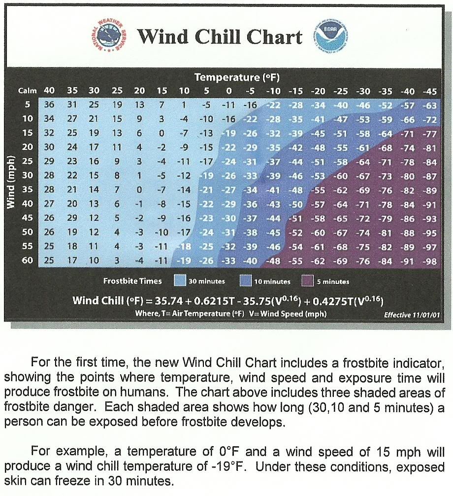
Welcome to City-Data.com Forum!
U.S. CitiesCity-Data Forum Index
Go Back   City-Data Forum > U.S. Forums > North Dakota
 [Register]
Please register to participate in our discussions with 2 million other members - it's free and quick! Some forums can only be seen by registered members. After you create your account, you'll be able to customize options and access all our 15,000 new posts/day with fewer ads.
View detailed profile (Advanced) or search
site with Google Custom Search

Search Forums  (Advanced)
Reply Start New Thread
 
Old 10-25-2009, 03:03 PM
 
Location: Spots Wyoming
18,700 posts, read 41,915,722 times
Reputation: 2147483647

Advertisements

South Dakota
Safe Travel USA
Climate History
http://ggweather.com/normals/

Beresford
South of town along I-29 & MP 36.3
http://safetravelusa.com/sd/camera_i...R/0/latest.jpg Looking North
http://safetravelusa.com/sd/camera_i...R/1/latest.jpg Looking South

Brookings
North of town along I-29 & MP 135.9
http://safetravelusa.com/sd/camera_i...X/1/latest.jpg Looking North
http://safetravelusa.com/sd/camera_i...X/2/latest.jpg Looking South

Chamberlain
East of town along I-90 & MP 268 looking west
http://safetravelusa.com/sd/camera_i...M/0/latest.jpg
West of town along I-90 & MP 258.8 looking east
http://safetravelusa.com/sd/camera_i...M/1/latest.jpg

Dell Rapids
West of town along I-29 & MP 89.4
http://safetravelusa.com/sd/camera_i...L/0/latest.jpg Looking North
http://safetravelusa.com/sd/camera_i...L/1/latest.jpg Looking South

Edgemont
West of town along US-18 & MP 1.7
http://safetravelusa.com/sd/camera_i...G/0/latest.jpg Looking West

Mitchell
East of town along I-90 & MP 333.8
http://safetravelusa.com/sd/camera_i...E/2/latest.jpg Looking East
http://safetravelusa.com/sd/camera_i...E/3/latest.jpg Looking West

Murdo
Murdo-West of town along I-90 & MP 189.5
http://safetravelusa.com/sd/camera_i...R/0/latest.jpg Looking East
http://safetravelusa.com/sd/camera_i...R/1/latest.jpg Looking West

North Sioux City
North of town along I-29 & MP 1.5 looking north
http://safetravelusa.com/sd/camera_i...C/0/latest.jpg
North of town along I-29 @ MP 3.7 looking south
http://safetravelusa.com/sd/camera_i...C/1/latest.jpg

Rapid City
East of town along I-90 & MP 63.1 looking east
http://safetravelusa.com/sd/camera_i...P/1/latest.jpg
West of town along I-90 & MP 54 looking west
http://safetravelusa.com/sd/camera_i...P/2/latest.jpg

Silver City
East of town at US-385 & SD-44
http://safetravelusa.com/sd/camera_i...V/0/latest.jpg Looking East
http://safetravelusa.com/sd/camera_i...V/1/latest.jpg Looking West

Sioux Falls
North of town along I-29 & MP 85.3
http://safetravelusa.com/sd/camera_i...D/2/latest.jpg Looking North
http://safetravelusa.com/sd/camera_i...D/3/latest.jpg Looking South
East of town along I-90 & MP 402 looking east
http://safetravelusa.com/sd/camera_i...D/4/latest.jpg
West of town along I-90 & MP 394.4 looking west
http://safetravelusa.com/sd/camera_i...D/5/latest.jpg
South of town along I-29 & MP 74.3
http://safetravelusa.com/sd/camera_i...D/6/latest.jpg Looking North
http://safetravelusa.com/sd/camera_i...D/7/latest.jpg Looking South
I-229 & E Benson Rd (Exit 9)
http://safetravelusa.com/sd/camera_i...9/0/latest.jpg Looking NorthEast
http://safetravelusa.com/sd/camera_i...9/1/latest.jpg Looking East
I-29 & W 41st St (Exit 77)
http://safetravelusa.com/sd/camera_i...S/0/latest.jpg Looking North
http://safetravelusa.com/sd/camera_i...S/1/latest.jpg Looking South

Sisseton
North of town along I-29 & MP 234
http://safetravelusa.com/sd/camera_i...S/0/latest.jpg Looking North
http://safetravelusa.com/sd/camera_i...S/1/latest.jpg Looking South

Spearfish
West of town along I-90 & MP 9.6 looking east
http://safetravelusa.com/sd/camera_i...R/1/latest.jpg Looking East
West of town along I-90 & MP 11 looking west
http://safetravelusa.com/sd/camera_i...R/2/latest.jpg Looking West

Sturgis
East of town along I-90 & MP 35.6
http://safetravelusa.com/sd/camera_i...G/1/latest.jpg Looking East
http://safetravelusa.com/sd/camera_i...G/2/latest.jpg Looking West
West of town along I-90 & MP 28.6
http://safetravelusa.com/sd/camera_i...G/3/latest.jpg Looking West

Vivian
North of town along US-83 & MP 101.9
http://safetravelusa.com/sd/camera_i...V/0/latest.jpg Looking North
http://safetravelusa.com/sd/camera_i...V/1/latest.jpg Looking South

Wall
East of town along I-90 & MP 111.5
http://safetravelusa.com/sd/camera_i...L/1/latest.jpg Looking West
http://safetravelusa.com/sd/camera_i...L/2/latest.jpg Looking East
West of town along I-90 & MP 108.4
http://safetravelusa.com/sd/camera_i...L/3/latest.jpg Looking West

Watertown
Watertown-North of town along I-29 & MP 179
http://safetravelusa.com/sd/camera_i...Y/0/latest.jpg Looking North
http://safetravelusa.com/sd/camera_i...Y/1/latest.jpg Looking South


Wyoming
Road Report Map
http://map.wyoroad.info/wtimapj/lo.html

Climate History
http://ggweather.com/normals/

I-90 From South Dakota border to Montana border

East of Sundance (mm 189)
WYDOT Travel Information Service (Cheyenne) From Port of Entry

East of Gillette (mm 128)
WYDOT Travel Information Service (Cheyenne) Looking SouthWest

Buffalo on I-90 at I-25 exit (mm 56.8)
WYDOT Travel Information Service (Cheyenne) Looking SouthEast

Piney Creek Between Buffalo and Sheridan
WYDOT Travel Information Service (Laramie) Looking North

Sheridan (mm 25)
WYDOT Travel Information Service (Laramie) Looking South

Dietz, Port of Entry, North of Sheridan
WYDOT Travel Information Service (Cheyenne) Looking South


I-80 From Nebraska border to Utah border

Pine Bluffs Near the Nebraska state line (mm 401)
WYDOT Travel Information Service (Laramie) Looking West

Cheyenne East Port of Entry (mm 371.89)
WYDOT Travel Information Service (Laramie) Looking West

RoundTop Near Cheyenne (mm 357.68)
WYDOT Travel Information Service (Laramie) Looking West

Harriman Between Cheyenne and Vedauwoo (mm 342)
WYDOT Travel Information Service (Cheyenne) Looking West

Remount (facing West) (mm 340.5)
WYDOT Travel Information Service (Laramie)

Vedauwoo Near the Vedauwoo exit (mm 330.70)
WYDOT Travel Information Service (Cheyenne) Looking West

Tavern Between the Summit and Vedauwoo (mp 326.9)
WYDOT Travel Information Service (Laramie) Looking West

Summit East (mm 325.8)
WYDOT Travel Information Service (Cheyenne)

Summit between Cheyenne and Laramie (mm 323.05)
WYDOT Travel Information Service (Laramie) Looking NorthWest

Herrick Lane (facing West) (mm 297.66)
WYDOT Travel Information Service (Cheyenne)

Cooper Cove (mm 279.36)
WYDOT Travel Information Service (Cheyenne)

Arlington East (mm 273)
WYDOT Travel Information Service (Laramie)

Arlington Interchange (mm 272)
WYDOT Travel Information Service (Cheyenne) Looking SouthEast

Wagonhound (mm 266.58)
WYDOT Travel Information Service (Cheyenne)

County Rd 402 (mm 262)
WYDOT Travel Information Service (Cheyenne)

Elk Mountain (mm 255.6)
WYDOT Travel Information Service (Cheyenne)

Walcott Junction 20 miles east of Rawlins (mm 235.23)
WYDOT Travel Information Service (Cheyenne) Looking East

Hadsell Interchange (mm 206)
WYDOT Travel Information Service (Laramie)

Bitter Creek (mm 141.83)
WYDOT Travel Information Service (Laramie) Looking West

Rock Springs, I-80 and Elk Street (mm 104.83)
WYDOT Travel Information Service (Cheyenne) Looking West

Green River Tunnel (mm 89)
WYDOT Travel Information Service (Laramie) Looking West

Granger 38 miles west of Rock Springs (mm 66.17)
WYDOT Travel Information Service (Laramie) Looking SouthWest

Evanston Port of Entry, Near the Utah state line (mm 0.4)
WYDOT Travel Information Service (Laramie) Looking West


I-25 From Colorado to Buffalo Wy.

WyoHill, South of Cheyenne (mm 3.52)
WYDOT Travel Information Service (Cheyenne) Looking South

Cheyenne Port of Entry, South of Cheyenne (mm 6.35)
WYDOT Travel Information Service (Laramie) Looking North

Bordeaux, 10 miles south of Wheatland (mm 71.2)
WYDOT Travel Information Service (Laramie) Looking South

Casper, Bryan Stock Trail exit (mm 186.79)
WYDOT Travel Information Service (Laramie) Looking East

Grand Tetons Park

Jackson Hole
Grand Teton National Park Webcams

Moose Wyoming, Lost Creek Ranch
Lost Creek Ranch - Moose, Wyoming

Teton Village
Jackson Hole Resort Webcams

Yellowstone Park

Electric Peak
The Summit Lighthouse Webcam of Electric Peak*|*The Summit Lighthouse

Mammoth Hot Springs
Mammoth WebCam - Yellowstone National Park

Old Faithful
The Old Faithful Geyser WebCam - Yellowstone National Park


Montana
Climate History
http://ggweather.com/normals/

Glacier National Park

Apgar Mountain
http://mms.nps.gov/glac/webcams/amcam.jpg

Headquarters
http://mms.nps.gov/glac/webcams/hqcam.jpg

Lake McDonald
http://mms.nps.gov/glac/webcams/mcdcam.jpg

Two Medicine
http://mms.nps.gov/glac/webcams/tmcam.jpg


Little Bighorn National Monument
http://mms.nps.gov/libi/libicam1.jpg Looking East
http://mms.nps.gov/libi/libicam2.jpg Looking West


Yellowstone Park

Electric Peak
The Summit Lighthouse Webcam of Electric Peak*|*The Summit Lighthouse

Mammoth Hot Springs
Mammoth WebCam - Yellowstone National Park

Old Faithful
The Old Faithful Geyser WebCam - Yellowstone National Park


Towns

Billings KTVQ
Billings I-Cam - Montana's News Station - Fair. Accurate. To the Point. -

Billings KULR
http://bimedia.ftp.clickability.com/...ftp/webcam.jpg

Bitterroot Valley
Bitterroot Valley Real Time Camera

Bozeman
Bozeman I-Cam - Montana's News Station - Fair. Accurate. To the Point. - KBZK
Montana State University CatEye in the Big Sky Montana State University

Butte
Butte I-Cam - Montana's News Station - Fair. Accurate. To the Point. - KXLF

Canyon Ferry Reservoir
montanawalleyesunlimited.com

Cooke City
Cooke City Montana – Antlers Lodge Web Cams Antler's Lodge
http://www.cookecitywebcam.com/web3.jpg (broken link) Sinclair Station looking West
Cooke City MT - Soda Butte Lodge Soda Butte Lodge

Eureka
LiveApplet

Fort Benton
http://216.146.101.47/view/view.shtml RV Park

Fort Peck
montanawalleyesunlimited.com Unlimited Fort Peck Dam Cam[/url] Fort Peck Dam
Sunlitedreams Fort Peck Lake
montanawalleyesunlimited.com Hell Creek

Glacier
Montana Sky Web Cams User controlled

Great Falls
http://www.wrhnoaa.gov/tfx/data/graphics/tfx.jpg Great Falls Weather Cam. NOAA.
Great Falls Eyecam - Montana's News Station - Fair. Accurate. To the Point. - KRTV

Hamilton
Hamilton Eyecam - Montana's News Station - Fair. Accurate. To the Point. - KPAX

Helena
Carroll College - Carroll College Webcam Carroll College
Montana DEQ - Air Quality Conditions Web Cam Department Of Environmental Quality
http://www.azworld.com/offices_az/he...cam_helena.htm Great Northern Tower Center

Kalispell
Montana Sky Web Cams HWY 93 looking South
Kalispell Eyecam - Montana's News Station - Fair. Accurate. To the Point. - Kalispell Eyecam

Libby
Montana Sky Web Cams User controlled

Lincoln
Weather of Lincoln Montana Looking West

Miles City
milescityvoice.com Main Street

Missoula
Missoula Eyecam - Montana's News Station - Fair. Accurate. To the Point. - KPAX St. Patrick Hospital
Missoula County Webcam Missoula County
Missoulian Weather Missoulian News
University of Montana Grizcam University of Montana

Plains
Plains Eyecam - Montana's News Station - Fair. Accurate. To the Point. - Clark Fork Valley Hospital

Polson
Polson Eyecam - Montana's News Station - Fair. Accurate. To the Point. - KPAX St. Joseph's
http://www.skc.edu/webcam/index.html Salish College Campus

Red Lodge
Red Lodge Montana Webcam 13th and Broadway

Stevensville Ranger Station
Bitterroot Valley Real Time Camera

Swan Mountain
http://lpws002.pyrontechnologies.com...realty/cam.jpg

Whitefish
http://www.dayspringacademy.org/webcam/bigmtn.html Dayspring Academy

Yellowstone
Electric Peak and Yellowstone River Webcam Yellowstone river outside Garner
InstaCam Yellowstone river outside Livingston


Nebraska
Climate History
http://ggweather.com/normals/

Just select a green mark.
http://www2.dorstate.ne.us/Webcams/Default.aspx


North Dakota
Climate History
http://ggweather.com/normals/

SCAN Web*5.10 - Cameras
Reply With Quote Quick reply to this message

 
Old 10-06-2011, 04:54 PM
 
Location: Spots Wyoming
18,700 posts, read 41,915,722 times
Reputation: 2147483647
Default Just a reminder

What is Wind Chill?
It is the temperature it "Feels like" outside and is based on the rate of heat loss from exposed skin caused by the effects of wind and cold. As the wind increases, the body is cooled at a faster rate causing the skin temperature to drop. Wind Chill does not impact inanimate objects like car radiators and exposed water pipes, because these objects cannot cool below actual air temperature.

What is Frostbite?
Frostbite is an injury to the body caused by freezing body tissue. The most susceptible parts of the body are the extremities such as fingers, toes, ear lobes, or the tip of the nose. Symptoms include loss of feeling in the extremity and a white or pale appearance. Medical attentions is needed immediately for frostbite. The area should be SLOWLY re-warmed.

What is Hypothermia?
Hypothermia is abnormally low body temperature (below 95 degrees Fahrenheit). Warning signs include uncontrollable shivering, memory loss, disorientation, incoherence, slurred speech, drowsiness, and apparent exhaustion. Medical attention is needed immediately. If it is not available, begin warming the body SLOWLY.

Tips on how to dress during cold weather.
- Wear layers of loose-fitting, lightweight, warm clothing. Trapped air between the layers will insulate you. Outer garments should be tightly woven, water repellent, and hooded.
- Wear a hat, because 40% of your body heat can be lost from your head.
- Cover your mouth to protect your lungs from extreme cold.
- Mittens, snug at the wrist, are better than gloves.
- Try to stay dry and out of the wind.

--------------------------------------------------------------------------

Advisory
(Abbrev. ADVY)- Highlights special weather conditions that are less serious than a warning. They are for events that may cause significant inconvenience, and if caution is not exercised, it could lead to situations that may threaten life and/or property.

Watch
A watch is used when the risk of a hazardous weather or hydrologic event has increased significantly, but its occurrence, location, and/or timing is still uncertain. It is intended to provide enough lead time so that those who need to set their plans in motion can do so.

Warning
A warning is issued when a hazardous weather or hydrologic event is occurring, is imminent, or has a very high probability of occurring. A warning is used for conditions posing a threat to life or property.

Storm
Any disturbed state of the atmosphere, especially affecting the Earth's surface, and strongly implying destructive and otherwise unpleasant weather. Storms range in scale from tornadoes and thunderstorms to tropical cyclones to synoptic-scale extratropical cyclones.

Blizzard
(abbrev. BLZD)- A blizzard means that the following conditions are expected to prevail for a period of 3 hours or longer:

Sustained wind or frequent gusts to 35 miles an hour or greater; and
Considerable falling and/or blowing snow (i.e., reducing visibility frequently to less than ¼ mile)


Reply With Quote Quick reply to this message
 
Old 06-13-2012, 08:37 PM
 
Location: Spots Wyoming
18,700 posts, read 41,915,722 times
Reputation: 2147483647
Default Severe Thunderstorm Warning, East of Bowman, 6-13-2012

Severe weather statement
national weather service bismarck nd
933 pm cdt wed jun 13 2012

ndc001-037-085-140300-
/o.con.kbis.sv.w.0058.000000t0000z-120614t0300z/
adams nd-grant nd-sioux nd-
833 pm mdt wed jun 13 2012

...a severe thunderstorm warning remains in effect for southwestern
sioux...southwestern grant and eastern adams counties until 900 pm
mdt...

At 830 pm mdt...national weather service doppler radar indicated a
severe thunderstorm capable of producing quarter size hail...and
destructive winds in excess of 70 mph. This storm was located near
white butte...or 55 miles east of bowman...moving east at 45 mph.

Locations impacted include...
North lemmon.

Precautionary/preparedness actions...

Prepare immediately for large hail and damaging winds if you are in
the path of this storm. People outside should move to a shelter...
Preferably inside a strong building and away from windows.

Very heavy rain is also occurring with this storm...and may lead to
flash flooding. Do not drive your vehicle through flooded roadways.
Reply With Quote Quick reply to this message
 
Old 06-13-2012, 08:38 PM
 
Location: Spots Wyoming
18,700 posts, read 41,915,722 times
Reputation: 2147483647
Default Severe Thunderstorm Warning, Turtle Lake area, 6-13-2012

Severe weather statement
national weather service bismarck nd
925 pm cdt wed jun 13 2012

ndc055-057-083-140315-
/o.con.kbis.sv.w.0060.000000t0000z-120614t0315z/
mclean nd-mercer nd-sheridan nd-
925 pm cdt wed jun 13 2012

...a severe thunderstorm warning remains in effect for western
sheridan...east central mercer and eastern mclean counties until 1015
pm cdt...

At 919 pm cdt...national weather service doppler radar indicated a
severe thunderstorm capable of producing quarter size hail...and
damaging winds in excess of 60 mph. This storm was located near
falkirk...or 39 miles northwest of bismarck...moving northeast at 45
mph.

Locations impacted include...
Underwood...turtle lake...mercer...strawberry lake...mcclusky and
butte.

Precautionary/preparedness actions...

Very heavy rain is also occurring with this storm...and may lead to
flash flooding. Do not drive your vehicle through flooded roadways.
Reply With Quote Quick reply to this message
 
Old 06-13-2012, 08:40 PM
 
Location: Spots Wyoming
18,700 posts, read 41,915,722 times
Reputation: 2147483647
Default Severe Thunderstorm Warning, Antler ND, 6-13-2012

Severe weather statement
national weather service bismarck nd
932 pm cdt wed jun 13 2012

ndc009-075-140300-
/o.con.kbis.sv.w.0059.000000t0000z-120614t0300z/
bottineau nd-renville nd-
932 pm cdt wed jun 13 2012

...a severe thunderstorm warning remains in effect for central
renville and northwestern bottineau counties until 1000 pm cdt...

At 928 pm cdt...national weather service doppler radar indicated a
severe thunderstorm capable of producing quarter size hail...and
damaging winds in excess of 60 mph. This storm was located 5 miles
south of antler...or 40 miles west of bottineau...moving northeast at
30 mph.

Locations impacted include...
Antler and westhope.

Precautionary/preparedness actions...

This storm has exhibited some weak rotation. Tornadoes can develop
quickly from severe thunderstorms. Although one is not immediately
likely...if a tornado is spotted...act quickly and move to a place of
safety inside a sturdy structure... Such as a basement or small
interior room.

Report severe weather to the national weather service in bismarck at
701-223-4582.
Reply With Quote Quick reply to this message
 
Old 06-15-2012, 10:23 PM
 
Location: Spots Wyoming
18,700 posts, read 41,915,722 times
Reputation: 2147483647
Default Severe Thunderstorm Warning, Sterling area, 6-15-2012

Severe weather statement
national weather service bismarck nd
1113 pm cdt fri jun 15 2012

ndc015-029-043-160422-
/o.exp.kbis.sv.w.0066.000000t0000z-120616t0415z/
burleigh nd-emmons nd-kidder nd-
1113 pm cdt fri jun 15 2012

...the severe thunderstorm warning for northwestern kidder...
Northwestern emmons and eastern burleigh counties will expire at 1115
pm cdt...

The line of storms which prompted the warning have weakened below
severe limits. However...gusty winds up to 50 mph and heavy rain are
still possible with these thunderstorms.
Reply With Quote Quick reply to this message
 
Old 06-23-2012, 07:10 AM
 
Location: Spots Wyoming
18,700 posts, read 41,915,722 times
Reputation: 2147483647
Default Lightning Safety Awareness Week: June 24-30, 2012

Summer is the peak season for one of the nation's deadliest weather phenomena— lightning. But don't be fooled, lightning strikes year round. The goal of this Website is to safeguard U.S. residents from lightning. In the United States, an average of 54 people are reported killed each year by lightning. To date, there have been 4 deaths in 2012. Find out the sad facts about lightning deaths in previous years.

NWS Lightning Safety
Reply With Quote Quick reply to this message
 
Old 07-24-2012, 09:44 PM
 
Location: Spots Wyoming
18,700 posts, read 41,915,722 times
Reputation: 2147483647
Default Severe Thunderstorm Warning, Bowman Area, 7-24-2012

Severe weather statement
national weather service rapid city sd
918 pm mdt tue jul 24 2012

sdc063-250345-
/o.con.kunr.sv.w.0210.000000t0000z-120725t0345z/
harding sd-
918 pm mdt tue jul 24 2012

...a severe thunderstorm warning remains in effect for northeastern
harding county until 945 pm mdt...

At 914 pm mdt...national weather service doppler radar indicated a
severe thunderstorm capable of producing quarter size hail...and
damaging winds in excess of 60 mph. This storm was located 6 miles
west of ludlow...or 17 miles north of buffalo...moving southeast at
30 mph.

Locations impacted include...
Buffalo...ludlow and ralph.

Precautionary/preparedness actions...

This storm has a history of producing large hail. Seek shelter now
inside a sturdy structure and stay away from windows.
Reply With Quote Quick reply to this message
 
Old 07-24-2012, 09:48 PM
 
Location: Spots Wyoming
18,700 posts, read 41,915,722 times
Reputation: 2147483647
Default Severe Thunderstorm Warning, East of Jamestown, 7-24-2012

Severe weather statement
national weather service eastern nd/grand forks nd
1031 pm cdt tue jul 24 2012

mnc027-167-ndc017-073-077-250400-
/o.con.kfgf.sv.w.0091.000000t0000z-120725t0400z/
cass nd-ransom nd-richland nd-clay mn-wilkin mn-
1031 pm cdt tue jul 24 2012

...a severe thunderstorm warning remains in effect for southwestern
clay county in northwest minnesota...and northwestern wilkin county
in west central minnesota...and northwestern richland...northeastern
ransom and southeastern cass counties in southeast north dakota until
1100 pm cdt...

At 1028 pm cdt...national weather service doppler radar indicated a
line of severe thunderstorms capable of producing ping pong ball size
hail...and damaging winds in excess of 60 mph. The storms were
located along a line extending from 2 miles southeast of enderlin to
3 miles southwest of wolverton...moving to the northeast at 25 mph.

Severe thunderstorms will be near...
Kindred and leonard around 1045 pm cdt.
Comstock...hickson and davenport around 1055 pm cdt.
Fargo...moorhead and glyndon around 1100 pm cdt.

Thereafter some other locations impacted by severe thunderstorms
include dilworth...mapleton...horace...casselton...sabin and rustad.

For motorists on interstate 29...severe thunderstorms will be
between...mile markers 43 and 70...

For motorists on interstate 94...severe thunderstorms will be between
north dakota mile marker 328 and minnesota mile marker 17...

Precautionary/preparedness actions...

Remember severe thunderstorms can and occasionally do produce
tornadoes with little or no advance warning.
Reply With Quote Quick reply to this message
 
Old 07-24-2012, 09:49 PM
 
Location: Spots Wyoming
18,700 posts, read 41,915,722 times
Reputation: 2147483647
Default Severe Thunderstorm Warning, East of Devils Lake, 7-24-3012

Severe thunderstorm warning
ndc035-063-250430-
/o.new.kfgf.sv.w.0093.120725t0328z-120725t0430z/

bulletin - immediate broadcast requested
severe thunderstorm warning
national weather service eastern nd/grand forks nd
1028 pm cdt tue jul 24 2012

the national weather service in grand forks has issued a

* severe thunderstorm warning for...
Grand forks county in northeast north dakota...
Nelson county in northeast north dakota...

* until 1130 pm cdt

* at 1023 pm cdt...national weather service doppler radar indicated a
severe thunderstorm capable of producing damaging winds in excess
of 60 mph. The storm was located 9 miles south of michigan...or 35
miles southeast of devils lake...moving to the east at 40 mph. Also
nickel size hail may accompany the damaging winds.

* the severe thunderstorm will be near...
Petersburg and kloten around 1035 pm cdt.
Niagara around 1045 pm cdt.
Logan center around 1050 pm cdt.
Orr and mccanna around 1100 pm cdt.

Thereafter some other locations impacted by the severe thunderstorm
include larimore...northwood...johnstown...honeyford...mek inock and
holmes.

Precautionary/preparedness actions...

Remember severe thunderstorms can and occasionally do produce
tornadoes with little or no advance warning.
Reply With Quote Quick reply to this message
Please register to post and access all features of our very popular forum. It is free and quick. Over $68,000 in prizes has already been given out to active posters on our forum. Additional giveaways are planned.

Detailed information about all U.S. cities, counties, and zip codes on our site: City-data.com.


Reply
Please update this thread with any new information or opinions. This open thread is still read by thousands of people, so we encourage all additional points of view.

Quick Reply
Message:


Over $104,000 in prizes was already given out to active posters on our forum and additional giveaways are planned!

Go Back   City-Data Forum > U.S. Forums > North Dakota

All times are GMT -6.

© 2005-2024, Advameg, Inc. · Please obey Forum Rules · Terms of Use and Privacy Policy · Bug Bounty

City-Data.com - Contact Us - Archive 1, 2, 3, 4, 5, 6, 7, 8, 9, 10, 11, 12, 13, 14, 15, 16, 17, 18, 19, 20, 21, 22, 23, 24, 25, 26, 27, 28, 29, 30, 31, 32, 33, 34, 35, 36, 37 - Top