Welcome to City-Data.com Forum!
U.S. CitiesCity-Data Forum Index
Go Back   City-Data Forum > U.S. Forums > New York > Syracuse area
 [Register]
Please register to participate in our discussions with 2 million other members - it's free and quick! Some forums can only be seen by registered members. After you create your account, you'll be able to customize options and access all our 15,000 new posts/day with fewer ads.
View detailed profile (Advanced) or search
site with Google Custom Search

Search Forums  (Advanced)
Reply Start New Thread
 
Old 07-22-2018, 06:28 AM
 
93,175 posts, read 123,783,345 times
Reputation: 18253

Advertisements

Quote:
Originally Posted by ckhthankgod View Post
Speaking of the highlighted area, this area of Burnet Avenue on its southern end comes to mind as another area: https://www.google.com/maps/@43.0520...7i13312!8i6656

There are storefronts where businesses could be and you still have Angotti's Italian restaurant, with the former DeJulio's building now empty.

This little business hub/concentration isn't too far away to the east on the southern edge of Eastwood: https://www.google.com/maps/@43.0548...7i13312!8i6656

Some businesses in that area: https://www.dominicksrestaurant.net/
Shiftys COLD BEER - HOT WINGS - LIVE MUSIC
Home - N.Y. Gianni's Bronx Style Pizza - Bronx Style Pizza in Syracuse NY
https://www.yelp.com/biz/rudys-barber-shop-syracuse
https://www.yelp.com/biz/pappys-ice-...orner-syracuse (actually still open)

Another area of potential development in the neighborhood: https://www.google.com/maps/@43.0532...7i13312!8i6656

Neighborhood info: Hawley-Green Neighbors

https://en.wikipedia.org/wiki/Hawley...toric_District

Hawley-Green

NEHDA
Further west on Burnet, there is the back side of this former train station(now Spectrum News is located on the front/Erie Boulevard East side of the building): https://goo.gl/maps/qg4UXjHwRh82

I don’t know if apartments or some form of housing would work given that I-690 is where the rail right of way was located. It may have the potential for commercial or business use though and could help add to the southern end of the somewhat gentrified/revitalized Hawley-Green neighborhood.

Further west down the street, this building was a former bookstore that could be used again as a bookstore: https://goo.gl/maps/M6pErEVu7RT2
Next door may be able to be used as a cafe or offices as well.

This 5 corners area of the neighborhood is a block north: https://goo.gl/maps/7DSJiwQnCSt
Some businesses in that area: http://hairanoia.net
Laci's Tapas Bar
https://m.facebook.com/Thanos-Import...9704291737533/
Syracuse Soapworks - Syracuse Soapworks Home page

This art gallery is a couple blocks to the east on Hawley: ArtRage Gallery – The Norton Putter Gallery

This is also in the neighborhood: DOMINICKS
and it is across the street from this park: https://goo.gl/maps/oAr28V4RqVv

Again, it is within close proximity to Downtown, University Hill and even “Little Italy”/North Salina Street. It is also known for those in the local LGBTQ community having businesses and helping to revitalize the neighborhood. A street view of a more revitalized area of the neighborhood: https://goo.gl/maps/rZU1KAz2x582

Last edited by ckhthankgod; 07-22-2018 at 06:57 AM..
Reply With Quote Quick reply to this message

 
Old 07-22-2018, 08:42 AM
 
93,175 posts, read 123,783,345 times
Reputation: 18253
Quote:
Originally Posted by ckhthankgod View Post
The bolded area: https://www.google.com/maps/@43.0014...7i13312!8i6656

In turn, this could help develop the South Salina Street corridor, which is the same street that this building is on: Sears Building

Businesses on the street in between: https://www.google.com/maps/@43.0198...6!9m2!1b1!2i38

Also, in this corridor, a potential use for this building: https://www.google.com/maps/@43.0255...7i13312!8i6656

Could be a mixed cultural center/museum similar to this: http://web1.bccnsweb.com/

Which could also house this organization: The Paul Robeson Performing Arts Company

Then, a couple of blocks south, the building on the right could be used for housing for mixed use for families, artists associated with the organization/facility above and for those looking to hone their craft as entrepreneurs at this facility across the street: South Side Innovation Center

https://www.google.com/maps/@43.0227...7i13312!8i6656

Other nearby properties could also be put on the rolls by using said folks as well. There also is potential for more infill on the street as well.
A couple of places that could add vibrancy to this Corridor: https://mysouthsidestand.com/more-ne...salina-street/
Reply With Quote Quick reply to this message
 
Old 07-26-2018, 09:50 PM
 
93,175 posts, read 123,783,345 times
Reputation: 18253
Quote:
Originally Posted by ckhthankgod View Post
Bolded area: https://www.google.com/maps/@43.0183...7i13312!8i6656

Development in that area could connect with development in the West Onondaga to South Avenue area referred to in the last sentence.

In between West Onondaga and Elmwood on South Avenue: https://www.google.com/maps/@43.0342...7i13312!8i6656


Also, speaking of the West Onondaga Street corridor, this bank: https://www.pathfinderbank.com/ is eventually opening a branch in this area of the corridor: https://www.google.com/maps/@43.0393...7i13312!8i6656

This was mentioned by this regional manager at the bank on a local radio show: https://www.syracuse.com/business-ne...nder_bank.html

This organization is also playing a part in regards to looking towards potential development in the corridor: https://www.jubilee-homes.org/
A segment about this corridor: How Can Syracuse's South Ave Corridor be Improved? New Study Shows Assets, Challenges, Possibility | WAER
Reply With Quote Quick reply to this message
 
Old 07-27-2018, 07:18 AM
 
93,175 posts, read 123,783,345 times
Reputation: 18253
Quote:
Originally Posted by ckhthankgod View Post
The bolded area: https://www.google.com/maps/@43.0014...7i13312!8i6656

In turn, this could help develop the South Salina Street corridor, which is the same street that this building is on: Sears Building

Businesses on the street in between: https://www.google.com/maps/@43.0198...6!9m2!1b1!2i38

Also, in this corridor, a potential use for this building: https://www.google.com/maps/@43.0255...7i13312!8i6656

Could be a mixed cultural center/museum similar to this: http://web1.bccnsweb.com/

Which could also house this organization: The Paul Robeson Performing Arts Company

Then, a couple of blocks south, the building on the right could be used for housing for mixed use for families, artists associated with the organization/facility above and for those looking to hone their craft as entrepreneurs at this facility across the street: South Side Innovation Center

https://www.google.com/maps/@43.0227...7i13312!8i6656

Other nearby properties could also be put on the rolls by using said folks as well. There also is potential for more infill on the street as well.
Another property in this area that came to mind, but I'm not sure about its condition is the former St. Anthony of Padua School: https://www.google.com/maps/@43.0244...7i13312!8i6656


I think it could be used as a school again that has a law and teaching/education focus, but also has a community service and skill trade requirement as well in order to graduate. I thought of this in honor of these people that have a connection to the city, in which the school would be named after: Vashon, George B. (1824-1878) | The Black Past: Remembered and Reclaimed
The Freedom Trail in Syracuse and Onondaga County, NY (2nd Black lawyer in the US, click on 2002 Onondaga Co. UGRR report to view where his office was located: https://www.google.com/maps/@43.0505...7i13312!8i6656 )


https://www.civilwarwomenblog.com/edmonia-highgate/
https://www.findagrave.com/memorial/...delle-highgate (tragic death could be also be used as learning experience)


https://heinonline.org/HOL/Page?hand...ction=journals
https://www.facebook.com/William-Her...3196843531116/


I think this would allow for a connection with the local relevant institutions(colleges/universities) and organizations, as well as people in relevant positions to play a part in the educational process of the school as well in terms of mentorship and development.

Last edited by ckhthankgod; 07-27-2018 at 07:46 AM..
Reply With Quote Quick reply to this message
 
Old 07-27-2018, 07:54 AM
 
93,175 posts, read 123,783,345 times
Reputation: 18253
Quote:
Originally Posted by ckhthankgod View Post
Also, development on South Geddes Street would serve an area where the city's Hispanic/Latino community is concentrated, but is also a very culturally diverse area still.

In turn, you may see more development in this area that had development initiated via Syracuse University's Near Westside Initiative/SALT District. https://en.wikipedia.org/wiki/SALT_District

https://www.google.com/maps/@43.0465...7i13312!8i6656 the red building houses this: La Casita | Home as well as apartments slated for artists: https://www.syracusenewtimes.com/apa...ouldnt-afford/

The orange and gray building: SALTQuarters | Artist-in-Residence Program

Others that came to the area and revitalized some properties: https://www.syracuse.com/news/index...._syracuse.html

More development in that area: https://www.homehq.org/about-the-project/

Located in that area or nearby: https://www.hillside.com/

Member Supported Public Television, Radio | PBS | WCNY

https://www.facebook.com/LipeArtPark/
street view: https://www.google.com/maps/@43.0466...7i13312!8i6656 (neighborhood is across the street)

Delavan Center Home

Pulse Fitness Studio | Central New York

Case Supply

https://www.yelp.com/biz/the-kind-co...mpany-syracuse

https://www.oneida-air.com/

https://www.urbanlifeathletics.com/ (in building across from art park)

Home Page

Syracuse Habitat for Humanity

https://proliteracy.org/

Also, a building in the neighborhood that artists tag(is actually allowed by owner): https://www.google.com/maps/@43.0454...7i13312!8i6656

https://www.google.com/maps/@43.0449...7i13312!8i6656

Actually on South Geddes and West Fayette: The Gear Factory Syracuse :: Home

Also, that area is situated in between Downtown and the Tipperary Hill neighborhood, which is known for its pub/restaurants, Burnet Park(inc. the Rosamond Gifford Zoo) and Irish population. West Fayette Street links all 3 together.
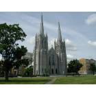
In the area above and in a similar fashion as the post above, I also think the former St. Lucy's Academy should be used again as a school(next to the church on the left): https://www.google.com/maps/@43.0505...7i13312!8i6656


This could have a bilingual and multicultural aspect with an arts focus, which ties in what the Near Westside Initiative was trying to do with the demographics of the neighborhood in mind. Again, I would also offer up a requirement of community service and a skill trade in order to graduate in this case as well. Those companies, organizations and other entities that are in or near the neighborhood currently could also participate in the educational process and to make it a community school.


Also, this grocery store closed recently and it would be nice to get a new store in the same space in order to have access to healthy food and in terms of employment for the neighborhood: https://www.google.com/maps/@43.0434...7i13312!8i6656

Last edited by ckhthankgod; 07-27-2018 at 08:02 AM..
Reply With Quote Quick reply to this message
 
Old 07-27-2018, 03:00 PM
 
93,175 posts, read 123,783,345 times
Reputation: 18253
Quote:
Originally Posted by ckhthankgod View Post
Further west on Burnet, there is the back side of this former train station(now Spectrum News is located on the front/Erie Boulevard East side of the building): https://goo.gl/maps/qg4UXjHwRh82

I don’t know if apartments or some form of housing would work given that I-690 is where the rail right of way was located. It may have the potential for commercial or business use though and could help add to the southern end of the somewhat gentrified/revitalized Hawley-Green neighborhood.

Further west down the street, this building was a former bookstore that could be used again as a bookstore: https://goo.gl/maps/M6pErEVu7RT2
Next door may be able to be used as a cafe or offices as well.

This 5 corners area of the neighborhood is a block north: https://goo.gl/maps/7DSJiwQnCSt
Some businesses in that area: http://hairanoia.net
Laci's Tapas Bar
https://m.facebook.com/Thanos-Import...9704291737533/
Syracuse Soapworks - Syracuse Soapworks Home page

This art gallery is a couple blocks to the east on Hawley: ArtRage Gallery – The Norton Putter Gallery

This is also in the neighborhood: DOMINICKS
and it is across the street from this park: https://goo.gl/maps/oAr28V4RqVv

Again, it is within close proximity to Downtown, University Hill and even “Little Italy”/North Salina Street. It is also known for those in the local LGBTQ community having businesses and helping to revitalize the neighborhood. A street view of a more revitalized area of the neighborhood: https://goo.gl/maps/rZU1KAz2x582
Some buildings in this area/corridor that could be used for apartments above and/or retail at the bottom: https://www.google.com/maps/@43.0562...7i13312!8i6656


https://www.google.com/maps/@43.0586...7i13312!8i6656


https://www.google.com/maps/@43.0605...7i13312!8i6656 (something may be in the works currently)


https://www.google.com/maps/@43.0620...7i13312!8i6656


https://www.google.com/maps/@43.0634...7i13312!8i6656 (orange covering over the entrance)


https://www.google.com/maps/@43.0549...7i13312!8i6656


https://www.google.com/maps/@43.0542...7i13312!8i6656


https://www.google.com/maps/@43.0569...7i13312!8i6656 (hospital may have plans for the properties, area known as Prospect Hill)


https://www.google.com/maps/@43.0618...7i13312!8i6656


https://www.google.com/maps/@43.0661...7i13312!8i6656 (former brewery from when the area was highly German before becoming highly Italian and is now arguably the most culturally diverse urban area in Upstate NY)


https://www.google.com/maps/@43.0652...7i13312!8i6656


https://www.google.com/maps/@43.0657...7i13312!8i6656 (is currently shut down)


https://www.google.com/maps/@43.0661...7i13312!8i6656 (yes, it is what it says it is)


https://www.google.com/maps/@43.0661...7i13312!8i6656


https://www.google.com/maps/@43.0681...7i13312!8i6656


https://www.google.com/maps/@43.0682...7i13312!8i6656


Infill potential: https://www.google.com/maps/@43.0548...7i13312!8i6656


https://www.google.com/maps/@43.0681...7i13312!8i6656


A couple of properties leading into the Wolf Street business district/neighborhood: https://www.google.com/maps/@43.0699...7i13312!8i6656


https://www.google.com/maps/@43.0704...7i13312!8i6656


https://www.google.com/maps/@43.0713...7i13312!8i6656


Those 3 buildings are also not too far from Destiny USA, the Regional Market or the Transportation center(Bus and Train station), NBT Bank Stadium or even the Franklin Square area. Some Wolf Street businesses: https://www.google.com/maps/@43.0748...7i13312!8i6656


Potential for infill on that street: https://www.google.com/maps/@43.0805...7i13312!8i6656


A nearby employer: https://www.google.com/maps/@43.0817...7i13312!8i6656


Another potential site for infill in the area: https://www.google.com/maps/@43.0717...7i13312!8i6656


An example of an industrial building nearby that has been revitalized for housing: https://www.google.com/maps/@43.0766...7i13312!8i6656
Syracuse Premier Apartments | Hiawatha Heights


An organization that serves this side of town: Northside UP | CenterState CEO


It is an area within good urban bones that has the potential to be a more vibrant area of the city in its own right, while being a straight shot(biking, walking, driving, etc.) down North Salina to Downtown as well.


Another street/area on this side of town that has seen some development and has the potential for more: https://www.google.com/maps/@43.0599...7i13312!8i6656


As well as another: https://www.google.com/maps/@43.0725...6!9m2!1b1!2i38
http://courtwoodlawnnorthgateway.blo...-woodlawn.html (north of Grant Boulevard is more stable and working/middle class, while blending in with Lyncourt, an adjacent suburb in the town of Salina)
Reply With Quote Quick reply to this message
 
Old 07-27-2018, 04:41 PM
 
93,175 posts, read 123,783,345 times
Reputation: 18253
Quote:
Originally Posted by ckhthankgod View Post
Some buildings in this area/corridor that could be used for apartments above and/or retail at the bottom: https://www.google.com/maps/@43.0562...7i13312!8i6656


https://www.google.com/maps/@43.0586...7i13312!8i6656


https://www.google.com/maps/@43.0605...7i13312!8i6656 (something may be in the works currently)


https://www.google.com/maps/@43.0620...7i13312!8i6656


https://www.google.com/maps/@43.0634...7i13312!8i6656 (orange covering over the entrance)


https://www.google.com/maps/@43.0549...7i13312!8i6656


https://www.google.com/maps/@43.0542...7i13312!8i6656


https://www.google.com/maps/@43.0569...7i13312!8i6656 (hospital may have plans for the properties, area known as Prospect Hill)


https://www.google.com/maps/@43.0618...7i13312!8i6656


https://www.google.com/maps/@43.0661...7i13312!8i6656 (former brewery from when the area was highly German before becoming highly Italian and is now arguably the most culturally diverse urban area in Upstate NY)


https://www.google.com/maps/@43.0652...7i13312!8i6656


https://www.google.com/maps/@43.0657...7i13312!8i6656 (is currently shut down)


https://www.google.com/maps/@43.0661...7i13312!8i6656 (yes, it is what it says it is)


https://www.google.com/maps/@43.0661...7i13312!8i6656


https://www.google.com/maps/@43.0681...7i13312!8i6656


https://www.google.com/maps/@43.0682...7i13312!8i6656


Infill potential: https://www.google.com/maps/@43.0548...7i13312!8i6656


https://www.google.com/maps/@43.0681...7i13312!8i6656


A couple of properties leading into the Wolf Street business district/neighborhood: https://www.google.com/maps/@43.0699...7i13312!8i6656


https://www.google.com/maps/@43.0704...7i13312!8i6656


https://www.google.com/maps/@43.0713...7i13312!8i6656


Those 3 buildings are also not too far from Destiny USA, the Regional Market or the Transportation center(Bus and Train station), NBT Bank Stadium or even the Franklin Square area. Some Wolf Street businesses: https://www.google.com/maps/@43.0748...7i13312!8i6656


Potential for infill on that street: https://www.google.com/maps/@43.0805...7i13312!8i6656


A nearby employer: https://www.google.com/maps/@43.0817...7i13312!8i6656


Another potential site for infill in the area: https://www.google.com/maps/@43.0717...7i13312!8i6656


An example of an industrial building nearby that has been revitalized for housing: https://www.google.com/maps/@43.0766...7i13312!8i6656
Syracuse Premier Apartments | Hiawatha Heights


An organization that serves this side of town: Northside UP | CenterState CEO


It is an area within good urban bones that has the potential to be a more vibrant area of the city in its own right, while being a straight shot(biking, walking, driving, etc.) down North Salina to Downtown as well.


Another street/area on this side of town that has seen some development and has the potential for more: https://www.google.com/maps/@43.0599...7i13312!8i6656


As well as another: https://www.google.com/maps/@43.0725...6!9m2!1b1!2i38
Court-Woodlawn Task Force: Click Walkable Court Woodlawn - Butternut Circle (north of Grant Boulevard is more stable and working/middle class, while blending in with Lyncourt, an adjacent suburb in the town of Salina)
Another example of the bolded: https://www.google.com/maps/@43.0683...7i13312!8i6656
Reply With Quote Quick reply to this message
 
Old 07-30-2018, 07:14 AM
 
93,175 posts, read 123,783,345 times
Reputation: 18253
Quote:
Originally Posted by ckhthankgod View Post
Yes, both are a couple that come to mind due to having some investment, but they could definitely see even more investment and revitalization.


Another area I'll throw out there is the Park Avenue area behind Automobile Row(West Genesee Street) and north of Erie Boulevard West.


I also thought about Elmwood around Glenwood/Valley Drive/South Ave and the portion of the Valley between the Valley Plaza and Seneca Turnpike. Both have the bones and some businesses currently in those areas, but have room for more. Perhaps the area of West Onondaga to South Ave through to about Bellevue Ave near the future ShopRite grocery store.

Any others?
In terms of this area, it has seen some revitalization of properties such as "the 5 Sisters" here: https://www.timecapdevelopment.net/t...rs_park_avenue


My Central New York: Park Avenue Boulevard Architectural Walking Tour - This Sunday (Oct 3)


https://www.google.com/maps/@43.0520...7i13312!8i6656


There has also been some new loft apartments put into former industrial buildings as well: https://www.dietzlofts.com/
https://www.google.com/maps/place/Th...!4d-76.1641532 (older street view)


538 Erie | Experience Modern Living Downtown Syracuse
https://www.google.com/maps/@43.0496...7i13312!8i6656 (just inside of the area mentioned)


This building that was the site of the former Marcellus casket Factory has been revitalized as well: https://www.google.com/maps/@43.0500...6!9m2!1b1!2i38


Also, this plaza in the former Sam Dell Car Dealership lot has been built up in recent years as well: https://www.google.com/maps/@43.0537...6!9m2!1b1!2i38


You also have these places within that area: https://www.middleagesbrewing.com/
Dom Polski | Syracuse Polish Home
Welcome
https://www.facebook.com/RainLoungeSyracuse/
https://www.facebook.com/Calca%C3%B1...4339781590681/
United Auto Supply > Home
https://www.yelp.com/biz/park-grocery-and-meat-syracuse


A couple of schools: School Home | The Syracuse City School District | Syracuse, NY


http://www.sascs.org/ (the high school portion is in the area)


If the area can get more properties brought back to life(housing and commercial), which is a possibility due to its very close proximity to Downtown, it could be another city neighborhood in high(er) demand.
Reply With Quote Quick reply to this message
 
Old 07-30-2018, 03:52 PM
 
93,175 posts, read 123,783,345 times
Reputation: 18253
Quote:
Originally Posted by ckhthankgod View Post
Another property in this area that came to mind, but I'm not sure about its condition is the former St. Anthony of Padua School: https://www.google.com/maps/@43.0244...7i13312!8i6656


I think it could be used as a school again that has a law and teaching/education focus, but also has a community service and skill trade requirement as well in order to graduate. I thought of this in honor of these people that have a connection to the city, in which the school would be named after: Vashon, George B. (1824-1878) | The Black Past: Remembered and Reclaimed
The Freedom Trail in Syracuse and Onondaga County, NY (2nd Black lawyer in the US, click on 2002 Onondaga Co. UGRR report to view where his office was located: https://www.google.com/maps/@43.0505...7i13312!8i6656 )


https://www.civilwarwomenblog.com/edmonia-highgate/
https://www.findagrave.com/memorial/...delle-highgate (tragic death could be also be used as learning experience)


https://heinonline.org/HOL/Page?hand...ction=journals
https://www.facebook.com/William-Her...3196843531116/


I think this would allow for a connection with the local relevant institutions(colleges/universities) and organizations, as well as people in relevant positions to play a part in the educational process of the school as well in terms of mentorship and development.
In relation to the school idea, similar to a couple of programs that East Syracuse-Minoa has, those with relevant skill trade skills like carpentry can help to rebuild homes in the neighborhood. Meaning, they can pick one property a year to revitalize using the skills they obtained from that trade program.

Also, the school could form a credit union for students, staff and community residents. If not it’s own credit union, it could contact a bank like this: https://www.oneunited.com , if not having both co-exist. Another local example of this idea is displayed by the Ukrainian community in the city’s Tipperary Hill neighborhood on the West Side: https://ukrainianfcu.org

What I am referring to in regards to ES-M programs: Carpentry Program Homepage

https://www.core-fcu.com/au_history.html

Last edited by ckhthankgod; 07-30-2018 at 04:05 PM..
Reply With Quote Quick reply to this message
 
Old 07-30-2018, 07:08 PM
 
93,175 posts, read 123,783,345 times
Reputation: 18253
Quote:
Originally Posted by ckhthankgod View Post
Some buildings in this area/corridor that could be used for apartments above and/or retail at the bottom: https://www.google.com/maps/@43.0562...7i13312!8i6656


https://www.google.com/maps/@43.0586...7i13312!8i6656


https://www.google.com/maps/@43.0605...7i13312!8i6656 (something may be in the works currently)


https://www.google.com/maps/@43.0620...7i13312!8i6656


https://www.google.com/maps/@43.0634...7i13312!8i6656 (orange covering over the entrance)


https://www.google.com/maps/@43.0549...7i13312!8i6656


https://www.google.com/maps/@43.0542...7i13312!8i6656


https://www.google.com/maps/@43.0569...7i13312!8i6656 (hospital may have plans for the properties, area known as Prospect Hill)


https://www.google.com/maps/@43.0618...7i13312!8i6656


https://www.google.com/maps/@43.0661...7i13312!8i6656 (former brewery from when the area was highly German before becoming highly Italian and is now arguably the most culturally diverse urban area in Upstate NY)


https://www.google.com/maps/@43.0652...7i13312!8i6656


https://www.google.com/maps/@43.0657...7i13312!8i6656 (is currently shut down)


https://www.google.com/maps/@43.0661...7i13312!8i6656 (yes, it is what it says it is)


https://www.google.com/maps/@43.0661...7i13312!8i6656


https://www.google.com/maps/@43.0681...7i13312!8i6656


https://www.google.com/maps/@43.0682...7i13312!8i6656


Infill potential: https://www.google.com/maps/@43.0548...7i13312!8i6656


https://www.google.com/maps/@43.0681...7i13312!8i6656


A couple of properties leading into the Wolf Street business district/neighborhood: https://www.google.com/maps/@43.0699...7i13312!8i6656


https://www.google.com/maps/@43.0704...7i13312!8i6656


https://www.google.com/maps/@43.0713...7i13312!8i6656


Those 3 buildings are also not too far from Destiny USA, the Regional Market or the Transportation center(Bus and Train station), NBT Bank Stadium or even the Franklin Square area. Some Wolf Street businesses: https://www.google.com/maps/@43.0748...7i13312!8i6656


Potential for infill on that street: https://www.google.com/maps/@43.0805...7i13312!8i6656


A nearby employer: https://www.google.com/maps/@43.0817...7i13312!8i6656


Another potential site for infill in the area: https://www.google.com/maps/@43.0717...7i13312!8i6656


An example of an industrial building nearby that has been revitalized for housing: https://www.google.com/maps/@43.0766...7i13312!8i6656
Syracuse Premier Apartments | Hiawatha Heights


An organization that serves this side of town: Northside UP | CenterState CEO


It is an area within good urban bones that has the potential to be a more vibrant area of the city in its own right, while being a straight shot(biking, walking, driving, etc.) down North Salina to Downtown as well.


Another street/area on this side of town that has seen some development and has the potential for more: https://www.google.com/maps/@43.0599...7i13312!8i6656


As well as another: https://www.google.com/maps/@43.0725...6!9m2!1b1!2i38
Court-Woodlawn Task Force: Click Walkable Court Woodlawn - Butternut Circle (north of Grant Boulevard is more stable and working/middle class, while blending in with Lyncourt, an adjacent suburb in the town of Salina)
A couple of examples of buildings on North Salina Street that has been revitalized with loft apartments: https://goo.gl/maps/M2FvSbzDpRm
https://www.apartmentfinder.com/New-...fts-Apartments

https://goo.gl/maps/V3m5xCrFg4p
Syracuse Premier Apartments | Flats at North Salina

On North State Street: https://goo.gl/maps/nQBxb4srb3L2
Syracuse Premier Apartments | Flats at North State
Reply With Quote Quick reply to this message
Please register to post and access all features of our very popular forum. It is free and quick. Over $68,000 in prizes has already been given out to active posters on our forum. Additional giveaways are planned.

Detailed information about all U.S. cities, counties, and zip codes on our site: City-data.com.


Reply
Please update this thread with any new information or opinions. This open thread is still read by thousands of people, so we encourage all additional points of view.

Quick Reply
Message:


Over $104,000 in prizes was already given out to active posters on our forum and additional giveaways are planned!

Go Back   City-Data Forum > U.S. Forums > New York > Syracuse area

All times are GMT -6. The time now is 08:49 AM.

© 2005-2024, Advameg, Inc. · Please obey Forum Rules · Terms of Use and Privacy Policy · Bug Bounty

City-Data.com - Contact Us - Archive 1, 2, 3, 4, 5, 6, 7, 8, 9, 10, 11, 12, 13, 14, 15, 16, 17, 18, 19, 20, 21, 22, 23, 24, 25, 26, 27, 28, 29, 30, 31, 32, 33, 34, 35, 36, 37 - Top