Please register to participate in our discussions with 2 million other members - it's free and quick! Some forums can only be seen by registered members. After you create your account, you'll be able to customize options and access all our 15,000 new posts/day with fewer ads.
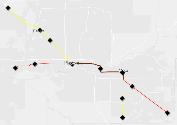
Threw this together real quick. My idea to bring commuter rail to Phoenix.
Using existing heavy rail structure would cut down on costs. Rebuild the station at Mesa (currently a tiled-slab), create one where the flat lot is at 5th and Farmer in Tempe, reclaim the old Phoenix Union Station. Build stations in the remaining downtowns. The yellow line is a commuter corridor between Surprise (Northwest) and South Chandler (South). The red line is a commuter corridor between Avondale (West) and Queen Creek (Southeast), with potential connections to Los Angeles (West) and Tucson (South) forming a greater regional rail network. The brown line is the shared stretch between the two lines, offering double-speed service between downtown Phoenix and Mesa (i.e. each line runs at 1 hour intervals, allowing for 30 minute commuter service between Phoenix and Mesa).
Might do another map for light rail / express bus service...
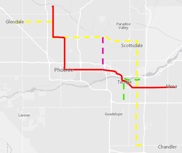
With the greater Valley serviced by heavy commuter rail, light rail can be centralized on the urban core (ideally, infill projects will bring more density to the Phoenix / Tempe downtown areas). The concept is to connect "Points of Interest", mainly retail and social areas.
The solid red line is the existing light rail in Phoenix (well, once the current construction is completed!).
The dotted yellow line is a proposed light rail between downtown Glendale, downtown Scottsdale, Tempe Marketplace and Chandler Fashion Center. It begins in downtown Glendale, and goes down Glendale Ave until it meets the existing light rail tracks. It then shares a stretch of track with the existing light rail, from Glendale/19thAve to Camelback/Central where it splits off and follows Camelback Road to downtown Scottsdale. The train would then turn southbound on Hayden/McClintock, and continue south until reaching Chandler Blvd, turning east for the final stretch to Chandler Fashion Center (A later extension could carry the rail the rest of the way to downtown Chandler).
The purple line is a "shuttle" line down 44th St, providing a "shortcut" from the Biltmore / Arcadia area to the 44th/Washington station´(also providing a shorter route to the airport for downtown Scottsdale).
The green line is my take on the Tempe Street Car project. The route would begin at Southern/Mill, and travel northbound on Mill Ave until reaching downtown Tempe. It would then turn eastbound on Rio Salado Pkwy, accessing the (under construction) business parks along Tempe Town Lake, as well as the commuter parking lots on the north end of Arizona State University. The street car would continue down Rio until reaching Tempe Marketplace, where connections can be made with local busses, Tempe Orbit services, and the proposed yellow line.
I support expanding the light rail system in the Phoenix area, however, as for commuter rail I am not sure if it would generate enough ridership. While commuter rail is cheaper to implement, the downside is that you have to be dependent on existing freight train right of way, which may not go where people would actually want to go and thus may not generate enough ridership for the system to be feasible.
Light rail on the other hand is more flexible and could better serve important catchment areas, thus generating higher ridership numbers and having a faster payback period to cover the upfront costs. If you saw the maps I posted earlier in this thread, you can see that my light rail expansion is far more expansive and serves several important catchment areas. My Pink, Purple, and Brown Lines would be popular with mall shoppers as they provide a convenient connection between different major malls.
To counter your points:
I'd offer tax cuts to businesses if they moved to the CBD (Central Business District -- Downtown), as well as subsidized passes for commuters. Both moves would increase ridership on commuter lines.
Phoenix has the heavy rail infrastructure, but it's hardly maximized for freight anymore. Most freight ends at the inland port on the west side. Freight crossing through mostly bypasses the greater Phoenix area.
While I like the idea of expanding light rail, it has a slow average speed. As is, the current stretch of light rail (Main/Sycamore to 19th/Bethany Home) takes over an hour to complete. With stops every mile or so, light rail is just too slow for reasonable cross-valley commuting. My idea is to instead focus light rail efforts on the in-filled areas of the Valley (Tempe-Phoenix-Scottsdale corridors), while offering quicker commuter options to outlying suburbs. Feeder bus services (think: Tempe Orbit lines) would bus commuters from neighborhoods to the suburb stations, and hourly train service would funnel commuters into downtown.
A massive U.S. HSR network with no direct connection between New York and Chicago? Until it was recently surpassed by Rio-Sao Paulo, it was the busiest airline market (city pair) in the world.
A massive U.S. HSR network with no direct connection between New York and Chicago? Until it was recently surpassed by Rio-Sao Paulo, it was the busiest airline market (city pair) in the world.
Agreed. I also think the Phoenix-Albuquerque-Dallas line wouldn't work too well, due to all the mountain ranges. A Phoenix-Tucson-El Paso-Dallas corridor (along the I-10 and I-20 corridors) would see less elevation changes. Same situation with the ABQ-Denvee stretch, I don't think 220mph service would be feasible with the mountains of northern New Mexico.
I just worked up a "Vision 2040" for Kansas City Rail Transit (in three maps - one a user friendly graphic, one a regional map, and the third zoomed in on the urban core, with a focus on streetcar lines.) A starter streetcar line is nearly completed, to connect the River Market to Union Station, by way of the Central Business District. This line is represented here in Red, but as you can see, I have gone far beyond that. There have also been serious proposals to develop commuter ("heavy") rail along existing tracks, and those are represented by the gray lines. Most of this should be pretty self-explanatory, though. Enjoy!
Please register to post and access all features of our very popular forum. It is free and quick. Over $68,000 in prizes has already been given out to active posters on our forum. Additional giveaways are planned.
Detailed information about all U.S. cities, counties, and zip codes on our site: City-data.com.

 Please register to participate in our discussions with 2 million other members - it's free and quick! Some forums can only be seen by registered members. After you create your account, you'll be able to customize options and access all our 15,000 new posts/day with fewer ads.