Please register to participate in our discussions with 2 million other members - it's free and quick! Some forums can only be seen by registered members. After you create your account, you'll be able to customize options and access all our 15,000 new posts/day with fewer ads.
Note that to find the "average" urban area density (ie not weighted), I used the Statistics Canada Urban Areas. StatsCan uses slightly different rules for deliniating urban areas than the US Census Bureau, so the urban areas aren't quite the same. It mostly doesn't matter much, but in the case of St Catherines, they include Niagara Falls and Welland in the urban area, which causes the urban area population to be double the one I had.
For Edmonton, they include some lower density suburbs like Strathcona and Fort Saskatchewan (but I didn't) in the urban area, so I just used the land areas of Edmonton Proper + St Albert, which is almost exactly what I used for my urban area. The density gradient for Edmonton is still surprisingly high... Maybe it's related to the way census tracts were deliniated causing Edmonton to have a higher weighted density? I'm not sure...
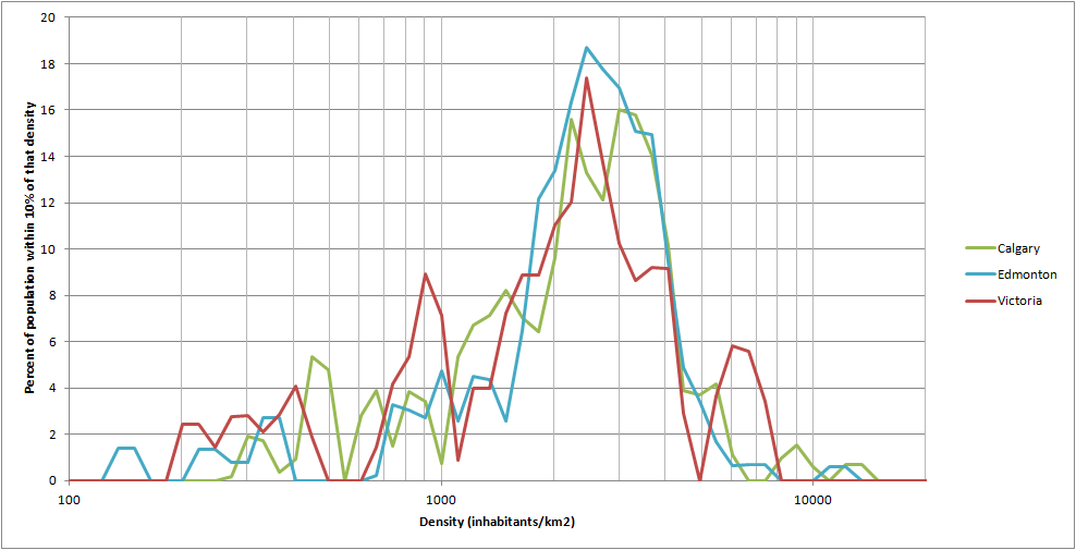
Here's the density distribution of Edmonton, Victoria and Calgary:
All three have about the same weighted density, but Victoria has a steeper gradient than Calgary. Edmonton's gradient is just a bit steeper than Victoria's (according to the numbers)... If a city has a low density gradient, that means that the density distribution graph would have a big spike in the middle (ie most people living at that density), and little at lower and higher densities. Does Edmonton's density distribution look more like Calgary's or Victoria's?
As for Paris, New York has 2.17 times more people living at hyper densities despite having an urban area that is only 1.7 times more populated. Plus, if you look at the average density of people living at 50,000ppsm or more, the value is greater for New York. Paris may have denser suburbs... but many of them are considerably less dense than the core. If you have a core density of 70,000ppsm with 20% of the population and suburbs averaging at 20,000ppsm (Paris) vs a core density of 90,000ppsm with 25% of the population and 60% in inner ring suburbs at 12,000ppsm and 15% in outer suburbs at 2,000ppsm (NY) you get the same density for both. I suspect that outside of the hyper dense areas of NY's urban area (Manhattan, parts of the Brooklyn, Bronx, Queens and parts of New Jersey likw Union City), much of the population of NY's urban area lives in relatively dense areas (simplified as inner ring suburbs) such as Staten Island, outer Bronx/Queens/Brooklyn, NE New Jersey, the areas near the Bronx (Mt Vernon, Yonkers) and Hempstead while relatively few people live in the very low density parts of the urban area that make up much of the land area. Paris might be a little denser though, but not significantly.
Your estimate for London sounds about right. London is definitely less dense than Paris, it has very few people living at above 50,000 ppsm and a lot more American style low density suburbs, but it still has a lot of areas in the 15,000-40,000ppsm range in the form of rowhouses and lowrise apartments.
As for Canadian metros between 1-2 million. Calgary, Edmonton and Ottawa's metros are just a bit more than 1 million, just their urban areas are slightly below 1 million. Vancouver's metro is a bit above 2 million, but the urban area is just below 2 million. Basically though, when you're a small country, you have more "gaps" in metro sizes like that. Australia is similar with a big gap between Melbourne and Brisbane, and another big gap between Adelaide and Gold Coast. Similarly, if you combine San Jose and SF-Oakland into one MSA, California would have the same kind of gap as Canada between 1-2 million, and California even has a slightly higher population.
As for whether New York would have the largest index... maybe, but others would come close. I'm still working on Barcelona, but the weighted density so far looks like it would be super high, much higher than New York's, so it could have a larger index even if its suburbs are all denser. More likely though, I would expect Barcelona's index to be around 3-4. If wikipedia's numbers are accurate, Moscow, Beijing, Nagoya might. It's difficult to go much denser than Manhattan, but maybe a city that has Manhattan like densities across a larger portion of the city, and then some moderate density suburbs, manufacturing areas, parks, etc to add land area with little in-between densities?
Edmonton's distribution looks more like Calgary than Victoria. I have visited both Victoria and Halifax. Victoria was surprisingly dense for a small West Coast city, at least near the core, but I expected Halifax to have a higher index given its age and its low density suburbs.
I forgot weighted density is an average rather than a median. The median Paris resident might be at a higher density than the median New York resident, but the high density core of New York skews the average. I still don't think any other city, and definitely not Barcelona, would have a higher density gradient index, because I think in most non-North American cities, a denser urban core is correlated with denser suburbs, but we'll have to see actual numbers. I'm curious if you do get a place with a high index, perhaps higher than 3.5.
Looking at the graph I looked, NYC had denser suburbs than just about all non-western US cities, looking at the density of the less dense 10-30 residents. I remember I took someone from the DC suburbs around Long Island and he was surprised how dense some of the housing was. A good portion of the lowest densities of the New York metro are taken by wealthy estate-size home, that are very small in population but use enormous amounts of land; helped by the income inequality of the metro. I'm envisioning as an extreme a metro area where the majority of people live in crowded tenements and the wealthy live on large palatial estates.
Speaking of tenements, look at the extreme densities of Manhattan 100 years ago:
Today the densest neighborhoods listed are close to 1/4 of the density in 1910.
London, Paris and NYC are I think, are the only 3 "megacities" built before mechanized transportation; a population above 3 million or so before subway or automobiles (I'm excluding streetcars). My definition might be a bit off, but I think they were much larger than the rest of cities worldwide in the late 19th century. So, why is London so much less dense? Around 1900, its densest neighborhoods were at levels of 60k/sq mile, maybe one somewhat higher. Perhaps London had a more decentralized job centers, so there was less incentive to cluster.
NYC's neighborhoods might have especially dense because it was on an island. But even after subways were extended to outer boroughs, some sections were still built at very high densities.
Just because two cities have the same weighted densities doesn't mean the density is distributed the same way. For example, in communism, cities got denser as you get away from the core:
Tokyo had 1.2 million people in 1700, and 6.35million in 1935.
1880 populations (approx)
London: 4.5 million
Paris: 2.7 million
New York: 2 million
Berlin: ~1.4 million
Regarding why London wasn't as dense... Maybe because it hit the industrial revolution earlier, combined with much more colonial wealth? The combination of more advanced technology and wealth might have meant lower density and earlier/more prevalent rail and horse based transit that would have further enabled lower densities. The first railway suburbs seem to have arisen around 1840, and the subway was opened in 1863. New York being on an island must have helped too, especially since the downtown was on the narrow tip of the island and I don't think there were any bridges yet. New York's subway opened in 1904 and the first rail-based transportation seems to have been around the 1860s.
Looks like the densest parts of NYC (historically) were around the Lower East Side, in neighbourhoods of ~5 storey apartments. Those are some pretty crazy densities, I wonder how much living space the average person had. On a related note, I wonder how much denser Manhattan would be if it's wealth was more comparable to the American average.
I wouldn't put too much weight on the density gradient numbers (for Canada) though, there's probably a margin of error of 20% on the urban area density and the weighted density numbers aren't totally representative of the city since some of the census tracts include both urban and rural land, with some cities having more of these census tracts than others (especially problematic with small cities). In the case of Victoria, a lot of census tracts like these were included around Saanichton and Brentwood Bay to the North of the city. It's worth noting that Victoria has a bit more core density than Halifax too.
Looks like the densest parts of NYC (historically) were around the Lower East Side, in neighbourhoods of ~5 storey apartments. Those are some pretty crazy densities, I wonder how much living space the average person had. On a related note, I wonder how much denser Manhattan would be if it's wealth was more comparable to the American average.
The living space the average person had in those neighborhoods would have been miserably low; most of the buildings are still there and in high demand but the current density is much lower (around 90-95 k / square mile). It must have had on average multiple people to a room, mostly whole families. While Manhattan as a whole was likely wealthier than America than average, there were large masses of poor people. The Lower East Side was an area where new immigrants would live, and then try to move out. Today, the densest parts of NYC have migrated a bit north to the Upper East Side (either 118 or 125k/sq mile) and the eastern side of Manhattan in between the Lower and Upper East Side.
Also, urban area boundaries are odd. I mentioned NYC appears to have the highest density suburbs of any non-western city from the maps. But SW Connecticut was counted as a separate urban area for some reason, even though it's connected to NYC. Where I live in Western Massachusetts, if you could carefully draw a path might be a continuous urban area. Here's the "urban area" I live in":
The strange gap on the west side of Holyoke and east of Northampton and Easthampton is from a small mountain range. Northampton has somewhat dense multifamily in and near the town center but also farmland, woods and some low density housing further out. Here's a sample of what the housing at different density levels (near the center of town):
In the demographia link about how many people live in 50,000+ people square mile densities, the Paris number was misleading low because the density was calculated at a neighborhood level (1-2 square miles) rather than the smaller tract level of other cities. Paris might come out close to NYC then.
I meant that I wonder what the densities of Manhattan census tracts today would be if Manhattan was more averagely wealthy. The amount of living space in the past might not have been completely miserable. The average amount of floorspace nationwide in 2005 was 916sf and the mean was 675sf*.
If you go with a rough estimate of the average amount of floorspace in Manhattan being 700sf, since despite being wealthy, floorspace is quite a bit more expensive, that means the average amount of floorspace would have been about 180sf. That amounts to 1080sf for a family of six. You could have a 100sf bathroom, a 300sf kitchen/common room, and three 190sf bedrooms and 100sf for storage. That's pretty similar to the living arrangement my mother had in the 70s in Budapest, except with a bit more storage space and the common area was shared between only a family of 4. I would say that my mother's living arrangement was modest but comfortable.
It was quite common for families in Budapest in those days to share kitchens and bathrooms with another family and have only bedrooms to themselves, now that's crowded. 19th century lumberjack camps in Ontario were pretty bad too. We visited one where it was one large single room building with dozens of 3x5ft bunk beds touching side by side all around the edge with a fireplace in the middle and some tables in between the beds and fireplace, maybe something like 30-40sf per man. When you think about it, university residences have relatively little floor space per person too with 2 students per bedroom, one big bathroom per floor and a big cafeteria/common area per residence. It would definitely amount to less than 200sf per student, quite possibly even under 150sf.
Now maybe they would have had less than 180sf per person in Manhattan in those times on average. Maybe the current estimate of 700sf/person is on the high end, and you also have to consider that workplaces and retail might not be 4 times "denser". And of course, 180sf would have been the average, some people would have lived in more crowded conditions, and the built density of these neighbourhoods may very well have gone up. Still, I think it would be possible to have much less living space per person in Manhattan without having miserable living conditions.
As for European cities, the problem is that they typically don't have anything equivalent to census tracts, data only exists for neighbourhoods or districts that have 15,000-200,000 people (depending on the city).
However, Barcelona has decently good data for the city proper and inner ring suburbs of L'Hospitalet de Llobregat, Santa Coloma de Gramenet, Sant Adria de Besos and Badalona. The average unit size is the size of the average neighbourhood, which is what the data was available for. In the United States and Canada, the average census tract has about 5000 people.
Barcelona
-weighted density: 80,362
-population: 1,627,138 people
-average unit size: 22,290 people
L'Hospitalet de Llobregat
-weighted density: 112,774 ppsm
-population: 265,891 people
-average unit size: 18,992 people
Sant Adria de Besos
-weighted density: 23,403 ppsm
-population: 34,157 people
-average unit size: 34,157 people
Santa Coloma de Gramenet
-weighted density: 117,229 ppsm
-population: 124,293 people
-average unit size: 8,286 people
Badalona
-weighted density: 84,176 ppsm
-population: 220,519 people
-average unit size: 6,486 people
Total of Barcelona and inner ring suburbs
-weighted density: 85,686ppsm
-population: 2,271,998
-average unit size: 16,584 people
The outer suburbs typically have data at only the suburb level.
Outer suburbs:
-weighted density: 17,697 ppsm
-population: 1,568,844 people
-average unit size: 16,009 people
Grand Total:
-weighted density: 57,915 ppsm
-population: 3,840,842
-average unit size: 16,344 people
If data was available for units the size of census tracts, I would estimate that the weighted density for Barcelona and the inner ring suburbs would be around 100,000ppsm and for the outer ring suburbs, around 30,000ppsm for aweighted density of about 70-75,000ppsm.
I'm not sure where the data for Barcelona came from in demographia. Maybe they used districts and only Barcelona proper? With the data I used to calculate the weighted density, I get 1.795 million people living at hyper densities and it would likely be even more using census tract sized units.
I'm working on Paris for now... but it's a very big urban area with lots of tiny suburbs, so it will take a bit of time still.
In a couple weeks, I think the data from the 2011 Canadian census will be released, so it will be interesting to see how the weighted densities will change. I'm going to guess that the Toronto UA's weighted density will increase to 16,000ppsm... we'll see how close I am. There's a few trends I expect to see:
-Decreasing household sizes leading to older low density suburban areas being less dense. However, this will also mean they will be less populated and have a smaller affect on the urban area, leading to little effect on the urban area overall.
-Decreasing household sizes in dense, stable inner city areas will mean fewer people living at moderately high (15,000-30,000ppsm) densities, which would have the effect of decreasing the weighted density
-Condo boom leading to much more hyper dense census tracts will have the effect of increasing the weighted density.
-Census tracts that saw a lot of growth, either from condos or from new subdivisions will be split into smaller census tracts. In 2006, these often had big variations of density within the census tract, so this will have the effect of increasing the weighted density.
Just finished Paris. The weighted density I got for the urban area was 28,773ppsm with a population of 10,374,358. Again, there was only data at the neighbourhood level for Paris proper and suburb level for its suburbs, so the population of the average unit was 20,382, or about 4 times a typical census tract, so the weighted density would be closer or even a bit above that of New York if census tract sized units were used.
Here's the breakdown for the different parts of the urban area.
City of Paris
-Population: 2,124,841 people
-Weighted density: 72,917 ppsm
-Average unit size: 26,573 people
Seine-Saint-Denis Department (NE inner ring suburbs)
-Population: 1,513,102 people
-Weighted Density: 20,813 ppsm
-Average unit size: 37,828 people
Hauts-de-Seine Department (Western inner ring suburbs)
-Population: 1,554,244 people
-Weighted Density: 33,159ppsm
-Average unit size: 20,451 people
Val-de-Marne Department (SE inner ring suburbs)
-Population: 1,316,751
-Weighted Density: 21,745ppsm
-Average Unit size: 31,351 people
Outer ring suburbs
-Population: 3,864,420 people
-Weighted Density: 8,236ppsm
-Average Unit size: 12,670 people
I meant that I wonder what the densities of Manhattan census tracts today would be if Manhattan was more averagely wealthy. The amount of living space in the past might not have been completely miserable. The average amount of floorspace nationwide in 2005 was 916sf and the mean was 675sf*.
I'm still a bit confused.
So, first the conditions in the extremely dense parts of Manhattan (100 years ago) were rather horrible. This link shows a typical layout:
Considering that the same areas today are much lower density yet the apartments are full suggest that most of the density was from too many people to a room. It's claimed the Lower East Side area of Manhattan was at the time the densest neighborhood in the world.
The inequality and extreme densities 100 years doesn't seem to affect the densities today. The current Lower East Side and East Village have high densities, but nothing unusual for Manhattan, so the old density levels have little effect on current densities. The neighborhood with the highest densities is the Upper East Side, which is newer and had few if any overcrowded tenements and is one of the wealthiest areas of the city. Since many of the wealthiest areas of the city are also the densest (lower 2/3rds of Manhattan) I don't think current inequality affects density much.
Also, the densest areas containing more wealth is somewhat recent. While Manhattan always had super rich enclaves, large portions of the island weren't considered particularly desirable until recently or at least just middle-class. In the early 60s, Manhattan had the highest crime rate in the city. Today, most of the island is near the bottom. The city is still extremely unequal in terms of living conditions. While housing conditions are no longer as cramped, look at the chart on this website on food insecurity:
Two city (and one other in the metro containing urban areas in New Jersey) congressional districts make the list for worst in the nation. Two city (+ 2 suburban districts) make the list for best in the nation. One other city district probably just makes the list.
Basically what I'm trying to say is that if you took a neighbourhood like the Upper East Side, but populated it with middle class or lower income people with more modest living conditions, I wonder how much the density would increase. The Upper East Side has a high density because the built density is high (higher than the Lower East Side), but if the amount of living space per person was more around what the average person could afford, the density would be even higher.
Those tenements look like they would have been pretty horribly crowded, but most of the tenement is made up of the kitchen and living room which are actually large enough. The problem is the shared bathroom and small number of bedrooms considering the size of families at the time. Adding a little bathroom, 1-2 bedrooms and increasing the size of the parents' bedroom a bit would have made the tenements much less horrible imo but only about 50% bigger. By the way, any idea what the average family size might have been? From 1850 to 1920 the fertility rate seems to have gone from 5 to 3 but I'd expect there would have been fewer children in the city.
As for Paris' outer suburbs, some have higher density apartment neighbourhoods, but mostly it's single family. Still I think they're a fair bit denser than the outer suburbs of most cities except Miami and the SW. The edge of the urban area in the outer suburbs is also quite jagged, so you wind up including a fair bit of farmland, although even the outer suburbs (technically called communes) that don't include farmland mostly have densities of 8000-15000ppsm.
Please register to post and access all features of our very popular forum. It is free and quick. Over $68,000 in prizes has already been given out to active posters on our forum. Additional giveaways are planned.
Detailed information about all U.S. cities, counties, and zip codes on our site: City-data.com.

 Please register to participate in our discussions with 2 million other members - it's free and quick! Some forums can only be seen by registered members. After you create your account, you'll be able to customize options and access all our 15,000 new posts/day with fewer ads.