Please register to participate in our discussions with 2 million other members - it's free and quick! Some forums can only be seen by registered members. After you create your account, you'll be able to customize options and access all our 15,000 new posts/day with fewer ads.
Is most of the higher density housing in Toronto high rises? I haven't found any neighborhoods in Toronto that looked like my NYC link. And it seems that Toronto has high rises scattered in areas that near the center.
I'm curious how the amount of high rises compares to New York. Maybe it's possible that proportionally Toronto has just as many?
According to emporis, Toronto proportionally has a bit more. In terms of city proper, New York has 1409 people per highrise while Toronto has 1140 people per high rise.
The reason Toronto doesn't have as many midrise neighbourhoods is mainly because it was much smaller than NYC a hundred years ago. In 1880, it was actually about 20 times smaller than NYC, 5 times smaller than Chicago, 4 times smaller than St Louis and 2-3 times smaller than San Francisco and Cincinnati. In 1930, it was about the same size as New York in 1850, Philadelphia in 1880 and Chicago in 1890. In 1930, Toronto was also about half the size of Detroit and already surpassed by Los Angeles. It's also worth noting that despite having been quite a bit bigger than Toronto pre-WWII, Chicago has relatively little midrise housing and even attached housing, certainly much less than NYC.
The closest Toronto has are small clusters of lowrise and midrise apartment buildings, but they're often setback a from the street a little and from each other. These exist in areas like Bathurst/St Clair, Avenue Road and the NE part of downtown. Otherwise, midrise residential consists of new(er) developments, like the St Lawrence neighbourhood or conversions of buildings like these which look like warehouses. I believe the densest parts of Toronto that aren't highrise are St Lawrence and Parkdale. The pre WWII housing stock is mostly 2-3 story homes that often have the basement or top floor rented out as separate units, with the buildings set back from the street and with usually only a few homes attached to each other (long rows are rare) such as these in Grange Park, right next to downtown. Places like Bright Street (which actually has a very small setback) are the exception to the rule and were often built in unplanned streets and not serviced. Most of the long rows (5+ units) of uniform attached housing is new construction, such as these upscale ones in Midtown.
What do you mean by having highrises scattered near the center though? Don't most cities have that?
I think you (memph, and hopefully the other posters) would find these stats interesting. This blogger calculated the weighted density of each metro area or rather the density of the average census block weighted by the number:
This puts an end to the silly myth "LA is denser than NYC". It doesn't matter if the last 1 million people in NYC live on giant lots, the average resident of the metro area lives in a denser spot (30,000 people per square mile) than the average LA resident (12,000 people per square mile). Note the densities sound higher than typical city densities because they are at the neighborhood level, so parks, industry, vacant land, offices that tend to lower a cities' density get ignored. (A district that is that has few people living in it gets weighted less)
Any thoughts on how Canadian cities would rank? My guess is Toronto would be the highest Canadian city, then Montreal, then Vancouver. Toronto might rank just below LA.
This graph shows you have the density is distributed in metro areas. You can see almost all of the people living at densities (> 20 k /sq km) are in the NY metro. Atlanta is a low density outlier. Boston's distribution is weirdly flat; lots of people living at both high and low densities. The Bay Area is lower density than LA because this graph combines the SF and San Jose metros; the first table separated them.
This would be more interesting if some Canadian and European cities were there. My guess is that they'd resemble western US cities in density profile more than eastern ones.
I think Montreal might rank higher than Toronto, so Montreal would be first, then Toronto, then Vancouver, followed by either Hamilton or Quebec City. While Montreal doesn't have as many residential highrises in it's core and suburbs, and it's suburban housing stock is less dense than Toronto's, it has a very dense inner city. Most of Montreal's inner city is 2-3 story attached apartments with little setback from the street and small yards. This census tract, bound by Ave Bloomfield, Boul de l'Acadie, Jarry O and Saint Roch has a density of 50,000ppsm, despite being almost entirely 2-3 storey apartments with 92.5% of the population living in buildings of 4 storeys or less. That census tract is what much of the inner city looks like, although with a density more around 30-40,000ppsm. Montreal's density distribution is probably quite similar to Boston and New York, while Toronto is more like LA. I think Toronto and Montreal would both be quite similar to LA in terms of the average census tract density.
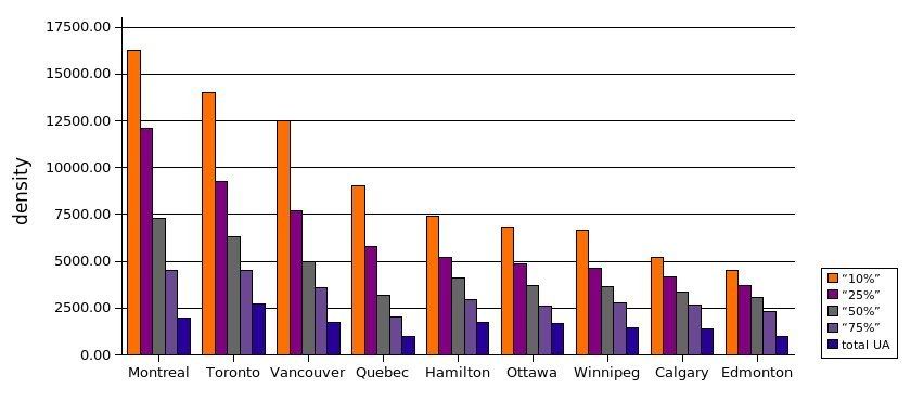
It shows the average density of the densest 10%, densest 25%, densest 50% and densest 75% of the urban area's census tracts and the density of the urban area as a whole in people per km2. As you can see, it's only when you look at the density of the whole urban area that Toronto beats Montreal. So the 10% densest census tracts of Montreal average out at 42,192ppsm, although it's worth noting that this isn't as impressive as if 10% of census tracts were 42,192ppsm or denser.
The reason I think Toronto might even beat out LA in average census tract density is that according to the hyper densities link, it has a little more people living at 50,000ppsm, despite the urban area being almost 3 times smaller, so in terms of high density, Toronto is up there, but Toronto also has an urban area density of 7040ppsm, which is comparable to LA, so LA can't really rise above Toronto thanks to its dense suburbs either. I guess I can't rule out LA having more moderate density (10,000-50,000ppsm) than Toronto, but so far there is no evidence of that, according to flar's data, Toronto's densest 50% census tracts average out at 16,284ppsm.
Anyways, I agree that average census tract density/density weighted by census tract is a better measurement for most purposes, although average urban area density is still useful to find out how much rural land a metropolitan area consumes, or maybe to a certain degree how much it costs to provide services like utilities and roads.
I think you (memph, and hopefully the other posters) would find these stats interesting. This blogger calculated the weighted density of each metro area or rather the density of the average census block weighted by the number:
This puts an end to the silly myth "LA is denser than NYC". It doesn't matter if the last 1 million people in NYC live on giant lots, the average resident of the metro area lives in a denser spot (30,000 people per square mile) than the average LA resident (12,000 people per square mile). Note the densities sound higher than typical city densities because they are at the neighborhood level, so parks, industry, vacant land, offices that tend to lower a cities' density get ignored. (A district that is that has few people living in it gets weighted less)
Any thoughts on how Canadian cities would rank? My guess is Toronto would be the highest Canadian city, then Montreal, then Vancouver. Toronto might rank just below LA.
I'm working on Montreal right now... It seems US urbanized are defined as as the adjacent census tracts with densities of 500ppsm or more... but do you know if they include census tracts that are below 500ppsm but completely surrounded by ones denser than 500ppsm?
Anyways, so far I've done the South Shore suburbs of Montreal and their weighted density is 7000ppsm, which includes several census tracts that contain lots of rural land (but also small towns or suburban developments that bring up the density). As a result Mont-Saint-Hilaire and Chambly for example wound up in the urban area.
If I understand it correctly, this is showing the amount of land that is over 50,000 people per square mile. So Baltimore has 0.03 miles where the density is over 50,000, with a population of 5,446 and a density of 181,533. Miami has no areas over 50,000 per square mile, and NYC has 51.85 square miles where the density is over 50,000.
If I understand it correctly, this is showing the amount of land that is over 50,000 people per square mile. So Baltimore has 0.03 miles where the density is over 50,000, with a population of 5,446 and a density of 181,533. Miami has no areas over 50,000 per square mile, and NYC has 51.85 square miles where the density is over 50,000.
Am I understanding the chart correctly?
I think so.
I just finished running the numbers for Montreal, the density weighted by population for the urban area is 14,121ppsm, making it second to only New York City's urban area (unless Toronto comes out ahead). So it's ahead of Los Angeles and ahead of the Bay Area (but not SF-Oakland). The Montreal urban area includes all but a tiny corner of Montreal Island (Senneville), all of Laval Island and Perrot Island, the Vaudreuil area, South Shore, North Shore, Chambly and Mont-St-Hilaire. I included all contiguous census tracts above 500ppsm adjacent to the core as well as all census tracts surrounded by tracts above 500ppsm which is the methodology used for US urban areas. I then took an average of all census tract densities with the census tracts weighted by population.
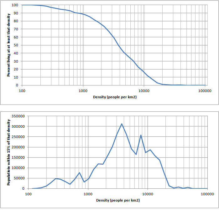
Here's a graph showing the distribution:
The distribution is very similar to LA's, but with more in the 200-3000 people per km2 range and more in the 12,000-20,000 people per km2 range and both have the greater portion of their population around 3000 people per km2. The 200-3000/km2 census tracts are mostly lower density suburbs, much of the off-island suburbs were around 1000-4000/km2, the lower density (200-1000/km2) stuff is mostly census tracts around the edge of the urban area that are partially rural and partially small towns, it looks like the edge of Montreal's urban area is less defined than LA's. Not in the same sense as East Coast cities though which have very low density subdivisions, for Montreal, it's mostly just large census tracts (3000-10000 people) that include both moderately dense residential and rural. As for the 12,000-20,000 people per km2, that's mostly lowrise apartment neighbourhoods that cover much of the inner city. Example (around 20,000/km2 or 50,000ppsm).
Just did Toronto, here's how it fares compared to the others. The urban area had a population of 4,739,358.
New York: 33,029
San Francisco-Oakland: 15,032
Montreal: 14,121
Toronto: 14,091
Bay Area: 12,906
Los Angeles: 12,557
Honolulu: 11,989
Chicago: 10,270
Philadelphia: 8,457
Boston: 7,711
San Diego: 7,186
Toronto actually turned out a little denser than I expected, I underestimated how dense North York and East York would be. Since most of the 2006-2011 growth for Toronto has been in the form of 10-60 storey condos and 15000ppsm subdivisions, I would expect it to increase to above Montreal's weighted density by the 2011 census. Also, I did all the suburbs (and former suburbs), for example Mississauga had a weighted density of 11,663 ppsm (pop 669559). I also did some smaller urban areas of Western Canada which were mostly 3000-6000ppsm... I don't think there is a single urban area in Canada with above 50,000 people that would be as low weighted density as Atlanta.
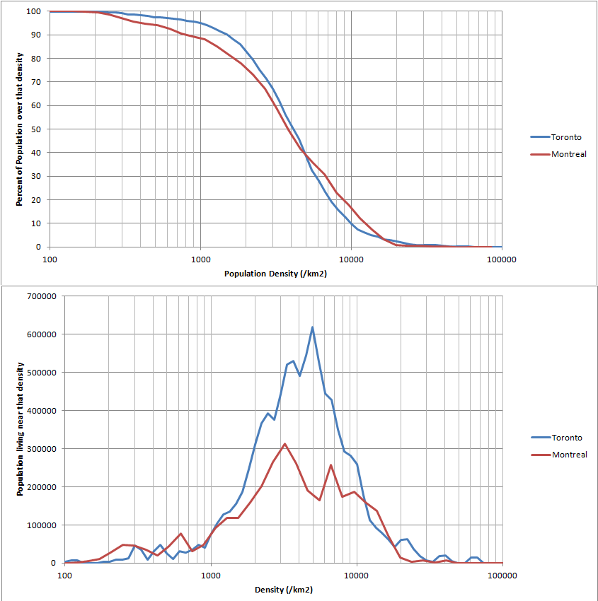
And a comparison of the density distribution for Toronto and Montreal's UAs:
So Toronto has compared to Montreal:
-fewer people living at densities of less than 1000 people per km2 (low density suburbs)
-more people living at densities of 1000-4000 people per km2 (moderate density suburbs)
-fewer people living at densities of 4000-17000 people per km2
-more people living at densities of 17000-66000 people per km2 (dense urban)
Another way to look at it... Montreal has a denser inner city but less high rise density and less dense suburbs.
Austin Contrarian also looked at the "density gradient", basically the weighted density divided by the overall density. A high density gradient means there a lot of variation in density within the urban area (ex New York) and a low density gradient means the density is about the same throughout (ex Phoenix). A value of 1 means the density is the same everywhere in the urban area.
I'm impressed with all your calculations. I'm a bit surprised how Toronto managed to be denser overall than Montreal.
Looking at the urban area graph by flar: Montreal comes out denser than Toronto in all parts of its urban area except the last 25% of the urban area. Since the last 25% percentile of urban area isn't very dense, its population should be relatively low and not have a big effect on the weighted density. Any thought why they don't match. Actually, looking at your graph, maybe the cause is that Toronto has a few very dense neighborhoods just skews the weighted density in favor of Toronto. But the amount of very dense neighborhoods in Toronto looks small in the percentile graph.
Either way, even if your numbers are a bit off, they're probably in the right range. The density gradients match the age of the cities: Toronto is a newer metro area with some old sections (like San Francisco/Oakland and DC) while Montreal is more similar to an old east coast city.
Atlanta is off the charts in density for a worldwide standard; it has a small medium density core while most of the population is in very low density suburbs. Most of the other American metros that were on the low end of weighted density had a much smaller population than Atlanta.
Montreal is actually slightly denser, as I posted higher up, Montreal was at 14121ppsm while Toronto was 14091ppsm.
As for flar's graphs, it says the 75 percentile is just barely denser for Montreal, so it's possible that the 0-40 percentile is denser but the 40-75 percentile is not, or something like that. The graph I made with the % living above a certain density gives you a better idea of what's happening.
I also ran the numbers for Oshawa and Hamilton's urban areas, which would likely be considered part of Toronto's urban area if they weren't seperate CSAs (similar to Riverside-San Bernardino or San Jose). Oshawa was at 5883ppsm and Hamilton at 7863ppsm. If you combine them with Toronto's urban area, you get 12940ppsm, which would be denser than SF-Oakland-SJ and still be denser than LA's urban area.
Please register to post and access all features of our very popular forum. It is free and quick. Over $68,000 in prizes has already been given out to active posters on our forum. Additional giveaways are planned.
Detailed information about all U.S. cities, counties, and zip codes on our site: City-data.com.

 Please register to participate in our discussions with 2 million other members - it's free and quick! Some forums can only be seen by registered members. After you create your account, you'll be able to customize options and access all our 15,000 new posts/day with fewer ads.